Assessment of Sentinel-2 spatial and temporal coverage based on the scene classification layer
2406.18584
0
0
Abstract
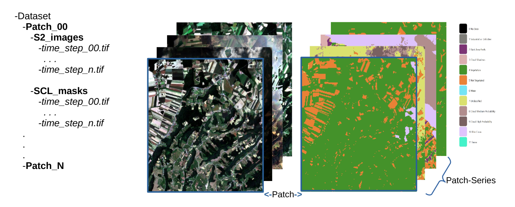
Since the launch of the Sentinel-2 (S2) satellites, many ML models have used the data for diverse applications. The scene classification layer (SCL) inside the S2 product provides rich information for training, such as filtering images with high cloud coverage. However, there is more potential in this. We propose a technique to assess the clean optical coverage of a region, expressed by a SITS and calculated with the S2-based SCL data. With a manual threshold and specific labels in the SCL, the proposed technique assigns a percentage of spatial and temporal coverage across the time series and a high/low assessment. By evaluating the AI4EO challenge for Enhanced Agriculture, we show that the assessment is correlated to the predictive results of ML models. The classification results in a region with low spatial and temporal coverage is worse than in a region with high coverage. Finally, we applied the technique across all continents of the global dataset LandCoverNet.
Create account to get full access
Overview
- This paper presents a quantitative analysis of Sentinel-2 satellite image coverage using the Scene Classification (SCL) mask, a tool that identifies cloud cover, water bodies, and other land surface features.
- The researchers used machine learning techniques to assess the accuracy and reliability of the SCL mask in different geographical regions and under various environmental conditions.
- The findings of this study have implications for the effective use of Sentinel-2 data in various applications, such as land cover analysis, building and road detection, and semantic segmentation.
Plain English Explanation
The Sentinel-2 satellite takes images of the Earth's surface, which are useful for many applications like tracking changes in land cover or monitoring natural disasters. However, these images can be partially obscured by clouds, water, and other features that make it harder to see what's on the ground.
The researchers in this study used a tool called the Scene Classification (SCL) mask to identify these obscured areas in the Sentinel-2 images. They then applied machine learning techniques to thoroughly evaluate how accurate and reliable the SCL mask is across different regions and environmental conditions.
The findings of this study can help researchers and organizations who use Sentinel-2 data to better understand the limitations and strengths of the SCL mask. This can inform their use of the data, such as when analyzing land cover changes, detecting buildings and roads, or performing semantic segmentation. By knowing the accuracy of the SCL mask, they can make more informed decisions about how to use the Sentinel-2 data effectively.
Technical Explanation
The researchers in this study used the Scene Classification (SCL) mask provided with Sentinel-2 satellite imagery to assess the coverage and accuracy of the data. The SCL mask identifies different land surface features, such as clouds, water bodies, and vegetation, which can obscure the view of the ground.
The team applied machine learning techniques, including confidence assessments for classification algorithms and self-supervised learning across spectral bands, to quantitatively analyze the performance of the SCL mask in different geographical regions and under various environmental conditions. This allowed them to identify the strengths and limitations of the SCL mask in accurately characterizing the land surface.
The results of this analysis provide valuable insights into the reliability and usability of Sentinel-2 data for a range of applications, such as land cover analysis, building and road detection, and semantic segmentation. By understanding the coverage and accuracy of the SCL mask, researchers and practitioners can make more informed decisions about how to effectively utilize Sentinel-2 imagery in their work.
Critical Analysis
The researchers in this study have provided a comprehensive and rigorous analysis of the Sentinel-2 SCL mask, highlighting its strengths and limitations across different geographical regions and environmental conditions. However, the paper does not address some potential caveats and areas for further research.
For instance, the study focuses on the accuracy of the SCL mask in identifying various land surface features, but it does not explore the potential impact of these inaccuracies on downstream applications, such as land cover change detection or semantic segmentation. Further research could investigate how the SCL mask's performance affects the reliability and robustness of these applications.
Additionally, the paper does not discuss the potential sources of error in the SCL mask, such as sensor calibration, image processing algorithms, or environmental factors. Understanding these underlying causes could help researchers and practitioners develop more accurate and reliable methods for characterizing land surface features in Sentinel-2 imagery.
Despite these limitations, the findings of this study provide valuable insights that can inform the effective use of Sentinel-2 data in a variety of applications. By understanding the accuracy and coverage of the SCL mask, users can make more informed decisions about how to best leverage this valuable satellite imagery.
Conclusion
The assessment of the Sentinel-2 SCL mask presented in this paper is an important contribution to the field of satellite remote sensing. The researchers have demonstrated the effectiveness of machine learning techniques in quantifying the accuracy and reliability of the SCL mask under different geographical and environmental conditions.
The findings of this study have significant implications for the use of Sentinel-2 data in a wide range of applications, from land cover analysis to building and road detection to semantic segmentation. By understanding the limitations and strengths of the SCL mask, researchers and practitioners can make more informed decisions about how to effectively utilize Sentinel-2 imagery in their work.
While the paper does not address all potential caveats and areas for further research, it provides a solid foundation for future studies to build upon. Continued efforts to better understand the performance of Sentinel-2 data and the tools used to analyze it will be crucial for advancing the field of satellite remote sensing and unlocking its full potential for addressing a wide range of real-world challenges.
This summary was produced with help from an AI and may contain inaccuracies - check out the links to read the original source documents!
Related Papers

S4: Self-Supervised Sensing Across the Spectrum
Jayanth Shenoy, Xingjian Davis Zhang, Shlok Mehrotra, Bill Tao, Rem Yang, Han Zhao, Deepak Vasisht
0
0
Satellite image time series (SITS) segmentation is crucial for many applications like environmental monitoring, land cover mapping and agricultural crop type classification. However, training models for SITS segmentation remains a challenging task due to the lack of abundant training data, which requires fine grained annotation. We propose S4 a new self-supervised pre-training approach that significantly reduces the requirement for labeled training data by utilizing two new insights: (a) Satellites capture images in different parts of the spectrum such as radio frequencies, and visible frequencies. (b) Satellite imagery is geo-registered allowing for fine-grained spatial alignment. We use these insights to formulate pre-training tasks in S4. We also curate m2s2-SITS, a large-scale dataset of unlabeled, spatially-aligned, multi-modal and geographic specific SITS that serves as representative pre-training data for S4. Finally, we evaluate S4 on multiple SITS segmentation datasets and demonstrate its efficacy against competing baselines while using limited labeled data.
6/28/2024

CAS: Confidence Assessments of classification algorithms for Semantic segmentation of EO data
Nikolaos Dionelis, Nicolas Longepe
0
0
Confidence assessments of semantic segmentation algorithms in remote sensing are important. It is a desirable property of models to a priori know if they produce an incorrect output. Evaluations of the confidence assigned to the estimates of models for the task of classification in Earth Observation (EO) are crucial as they can be used to achieve improved semantic segmentation performance and prevent high error rates during inference and deployment. The model we develop, the Confidence Assessments of classification algorithms for Semantic segmentation (CAS) model, performs confidence evaluations at both the segment and pixel levels, and outputs both labels and confidence. The outcome of this work has important applications. The main application is the evaluation of EO Foundation Models on semantic segmentation downstream tasks, in particular land cover classification using satellite Copernicus Sentinel-2 data. The evaluation shows that the proposed model is effective and outperforms other alternative baseline models.
6/27/2024
🤿
Deep Learning for Satellite Image Time Series Analysis: A Review
Lynn Miller, Charlotte Pelletier, Geoffrey I. Webb
0
0
Earth observation (EO) satellite missions have been providing detailed images about the state of the Earth and its land cover for over 50 years. Long term missions, such as NASA's Landsat, Terra, and Aqua satellites, and more recently, the ESA's Sentinel missions, record images of the entire world every few days. Although single images provide point-in-time data, repeated images of the same area, or satellite image time series (SITS) provide information about the changing state of vegetation and land use. These SITS are useful for modeling dynamic processes and seasonal changes such as plant phenology. They have potential benefits for many aspects of land and natural resource management, including applications in agricultural, forest, water, and disaster management, urban planning, and mining. However, the resulting satellite image time series (SITS) are complex, incorporating information from the temporal, spatial, and spectral dimensions. Therefore, deep learning methods are often deployed as they can analyze these complex relationships. This review presents a summary of the state-of-the-art methods of modelling environmental, agricultural, and other Earth observation variables from SITS data using deep learning methods. We aim to provide a resource for remote sensing experts interested in using deep learning techniques to enhance Earth observation models with temporal information.
4/12/2024

High-Resolution Building and Road Detection from Sentinel-2
Wojciech Sirko, Emmanuel Asiedu Brempong, Juliana T. C. Marcos, Abigail Annkah, Abel Korme, Mohammed Alewi Hassen, Krishna Sapkota, Tomer Shekel, Abdoulaye Diack, Sella Nevo, Jason Hickey, John Quinn
0
0
Mapping buildings and roads automatically with remote sensing typically requires high-resolution imagery, which is expensive to obtain and often sparsely available. In this work we demonstrate how multiple 10 m resolution Sentinel-2 images can be used to generate 50 cm resolution building and road segmentation masks. This is done by training a `student' model with access to Sentinel-2 images to reproduce the predictions of a `teacher' model which has access to corresponding high-resolution imagery. While the predictions do not have all the fine detail of the teacher model, we find that we are able to retain much of the performance: for building segmentation we achieve 78.3% mIoU, compared to the high-resolution teacher model accuracy of 85.3% mIoU. We also describe a related method for counting individual buildings in a Sentinel-2 patch which achieves R^2 = 0.91 against true counts. This work opens up new possibilities for using freely available Sentinel-2 imagery for a range of tasks that previously could only be done with high-resolution satellite imagery.
6/21/2024