Enhancing Active Learning for Sentinel 2 Imagery through Contrastive Learning and Uncertainty Estimation
2405.13285
0
0
➖
Abstract
In this paper, we introduce a novel method designed to enhance label efficiency in satellite imagery analysis by integrating semi-supervised learning (SSL) with active learning strategies. Our approach utilizes contrastive learning together with uncertainty estimations via Monte Carlo Dropout (MC Dropout), with a particular focus on Sentinel-2 imagery analyzed using the Eurosat dataset. We explore the effectiveness of our method in scenarios featuring both balanced and unbalanced class distributions. Our results show that for unbalanced classes, our method is superior to the random approach, enabling significant savings in labeling effort while maintaining high classification accuracy. These findings highlight the potential of our approach to facilitate scalable and cost-effective satellite image analysis, particularly advantageous for extensive environmental monitoring and land use classification tasks. Note on preliminary results: This paper presents a new method for active learning and includes results from an initial experiment comparing random selection with our proposed method. We acknowledge that these results are preliminary. We are currently conducting further experiments and will update this paper with additional findings, including comparisons with other methods, in the coming weeks.
Create account to get full access
Overview
- Introduces a new method for enhancing label efficiency in satellite imagery analysis
- Integrates semi-supervised learning (SSL) and active learning strategies
- Focuses on Sentinel-2 imagery and the Eurosat dataset
- Explores effectiveness in both balanced and unbalanced class distributions
- Shows superior performance for unbalanced classes compared to random selection
Plain English Explanation
This paper presents a new approach to make satellite image analysis more efficient by requiring fewer labeled examples. The method combines semi-supervised learning techniques, which can learn from both labeled and unlabeled data, with active learning strategies, which focus on selecting the most informative examples to label.
The researchers tested their method on Sentinel-2 satellite imagery from the Eurosat dataset. They found that their approach works particularly well when the data has an unbalanced class distribution, meaning some classes are much more common than others. In these cases, their method was able to achieve high accuracy while requiring significantly fewer labeled examples compared to a random selection approach.
This is important because labeling satellite imagery can be a time-consuming and costly process. The researchers' method has the potential to make satellite image analysis more scalable and cost-effective, which could be very useful for environmental monitoring and land use classification tasks that rely on this type of data.
Technical Explanation
The paper introduces a novel active learning approach that integrates semi-supervised learning (SSL) and uncertainty estimation via Monte Carlo Dropout (MC Dropout). The method uses contrastive learning, a type of SSL technique, to learn useful representations from both labeled and unlabeled Sentinel-2 satellite imagery in the Eurosat dataset.
The active learning component of the method focuses on selecting the most informative examples for human labeling. It uses the uncertainty estimates provided by MC Dropout to identify the samples that would provide the greatest benefit to the model if labeled.
The researchers evaluated their method in scenarios with both balanced and unbalanced class distributions. For the unbalanced case, they found that their approach outperformed a random selection baseline, achieving higher classification accuracy with significantly fewer labeled examples.
This is an important finding because real-world satellite imagery often has an unbalanced class distribution, and labeling large datasets can be extremely resource-intensive. The authors' method shows promise for reducing the labeling effort required for satellite image analysis while maintaining high performance.
Critical Analysis
The authors acknowledge that the results presented in this paper are preliminary, and they plan to conduct further experiments and comparisons with other methods in the coming weeks. This is important, as the initial results, while promising, may not generalize to a broader set of scenarios or datasets.
It would also be helpful to see more details on the specific active learning strategies used, as well as the contrastive learning approach. Understanding these technical details would allow for a more thorough evaluation of the method's strengths, weaknesses, and potential areas for improvement.
Additionally, the paper does not discuss potential limitations or challenges in applying this method to real-world satellite imagery analysis tasks. For example, the Eurosat dataset may not fully capture the complexity and diversity of satellite imagery encountered in practical applications. Exploring the method's performance on a wider range of datasets and use cases would strengthen the claims about its broader applicability.
Overall, this paper presents an interesting and potentially impactful approach to enhancing label efficiency in satellite image analysis. However, the preliminary nature of the results and the need for further investigation suggest that readers should approach the claims with a critical eye and look forward to the authors' future work in this area.
Conclusion
This paper introduces a novel method that combines semi-supervised learning and active learning to improve the efficiency of satellite imagery analysis. The key finding is that the proposed approach outperforms random selection, particularly in scenarios with unbalanced class distributions, resulting in significant savings in labeling effort while maintaining high classification accuracy.
These results suggest that the researchers' method has the potential to make satellite image analysis more scalable and cost-effective, which could have important implications for environmental monitoring, land use classification, and other applications that rely on this type of data. However, the preliminary nature of the findings means that further research and validation is needed to fully assess the method's performance and generalizability.
By highlighting the promise of this approach and the need for continued investigation, this paper contributes to the ongoing effort to develop more efficient and accessible tools for satellite imagery analysis, with the ultimate goal of supporting important real-world applications that benefit society.
This summary was produced with help from an AI and may contain inaccuracies - check out the links to read the original source documents!
Related Papers

Edge-guided and Class-balanced Active Learning for Semantic Segmentation of Aerial Images
Lianlei Shan, Weiqiang Wang, Ke Lv, Bin Luo
0
0
Semantic segmentation requires pixel-level annotation, which is time-consuming. Active Learning (AL) is a promising method for reducing data annotation costs. Due to the gap between aerial and natural images, the previous AL methods are not ideal, mainly caused by unreasonable labeling units and the neglect of class imbalance. Previous labeling units are based on images or regions, which does not consider the characteristics of segmentation tasks and aerial images, i.e., the segmentation network often makes mistakes in the edge region, and the edge of aerial images is often interlaced and irregular. Therefore, an edge-guided labeling unit is proposed and supplemented as the new unit. On the other hand, the class imbalance is severe, manifested in two aspects: the aerial image is seriously imbalanced, and the AL strategy does not fully consider the class balance. Both seriously affect the performance of AL in aerial images. We comprehensively ensure class balance from all steps that may occur imbalance, including initial labeled data, subsequent labeled data, and pseudo-labels. Through the two improvements, our method achieves more than 11.2% gains compared to state-of-the-art methods on three benchmark datasets, Deepglobe, Potsdam, and Vaihingen, and more than 18.6% gains compared to the baseline. Sufficient ablation studies show that every module is indispensable. Furthermore, we establish a fair and strong benchmark for future research on AL for aerial image segmentation.
5/29/2024
Active learning for efficient annotation in precision agriculture: a use-case on crop-weed semantic segmentation
Bart M. van Marrewijk, Charbel Dandjinou, Dan Jeric Arcega Rustia, Nicolas Franco Gonzalez, Boubacar Diallo, J'er^ome Dias, Paul Melki, Pieter M. Blok
0
0
Optimizing deep learning models requires large amounts of annotated images, a process that is both time-intensive and costly. Especially for semantic segmentation models in which every pixel must be annotated. A potential strategy to mitigate annotation effort is active learning. Active learning facilitates the identification and selection of the most informative images from a large unlabelled pool. The underlying premise is that these selected images can improve the model's performance faster than random selection to reduce annotation effort. While active learning has demonstrated promising results on benchmark datasets like Cityscapes, its performance in the agricultural domain remains largely unexplored. This study addresses this research gap by conducting a comparative study of three active learning-based acquisition functions: Bayesian Active Learning by Disagreement (BALD), stochastic-based BALD (PowerBALD), and Random. The acquisition functions were tested on two agricultural datasets: Sugarbeet and Corn-Weed, both containing three semantic classes: background, crop and weed. Our results indicated that active learning, especially PowerBALD, yields a higher performance than Random sampling on both datasets. But due to the relatively large standard deviations, the differences observed were minimal; this was partly caused by high image redundancy and imbalanced classes. Specifically, more than 89% of the pixels belonged to the background class on both datasets. The absence of significant results on both datasets indicates that further research is required for applying active learning on agricultural datasets, especially if they contain a high-class imbalance and redundant images. Recommendations and insights are provided in this paper to potentially resolve such issues.
4/4/2024
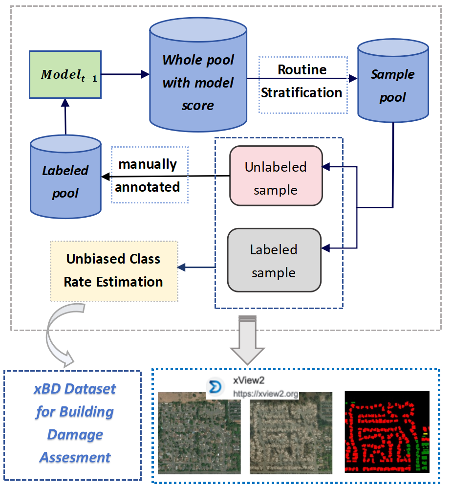
Towards Efficient Disaster Response via Cost-effective Unbiased Class Rate Estimation through Neyman Allocation Stratified Sampling Active Learning
Yanbing Bai, Xinyi Wu, Lai Xu, Jihan Pei, Erick Mas, Shunichi Koshimura
0
0
With the rapid development of earth observation technology, we have entered an era of massively available satellite remote-sensing data. However, a large amount of satellite remote sensing data lacks a label or the label cost is too high to hinder the potential of AI technology mining satellite data. Especially in such an emergency response scenario that uses satellite data to evaluate the degree of disaster damage. Disaster damage assessment encountered bottlenecks due to excessive focus on the damage of a certain building in a specific geographical space or a certain area on a larger scale. In fact, in the early days of disaster emergency response, government departments were more concerned about the overall damage rate of the disaster area instead of single-building damage, because this helps the government decide the level of emergency response. We present an innovative algorithm that constructs Neyman stratified random sampling trees for binary classification and extends this approach to multiclass problems. Through extensive experimentation on various datasets and model structures, our findings demonstrate that our method surpasses both passive and conventional active learning techniques in terms of class rate estimation and model enhancement with only 30%-60% of the annotation cost of simple sampling. It effectively addresses the 'sampling bias' challenge in traditional active learning strategies and mitigates the 'cold start' dilemma. The efficacy of our approach is further substantiated through application to disaster evaluation tasks using Xview2 Satellite imagery, showcasing its practical utility in real-world contexts.
5/29/2024
Context Matters: Leveraging Spatiotemporal Metadata for Semi-Supervised Learning on Remote Sensing Images
Maximilian Bernhard, Tanveer Hannan, Niklas Strau{ss}, Matthias Schubert
0
0
Remote sensing projects typically generate large amounts of imagery that can be used to train powerful deep neural networks. However, the amount of labeled images is often small, as remote sensing applications generally require expert labelers. Thus, semi-supervised learning (SSL), i.e., learning with a small pool of labeled and a larger pool of unlabeled data, is particularly useful in this domain. Current SSL approaches generate pseudo-labels from model predictions for unlabeled samples. As the quality of these pseudo-labels is crucial for performance, utilizing additional information to improve pseudo-label quality yields a promising direction. For remote sensing images, geolocation and recording time are generally available and provide a valuable source of information as semantic concepts, such as land cover, are highly dependent on spatiotemporal context, e.g., due to seasonal effects and vegetation zones. In this paper, we propose to exploit spatiotemporal metainformation in SSL to improve the quality of pseudo-labels and, therefore, the final model performance. We show that directly adding the available metadata to the input of the predictor at test time degenerates the prediction quality for metadata outside the spatiotemporal distribution of the training set. Thus, we propose a teacher-student SSL framework where only the teacher network uses metainformation to improve the quality of pseudo-labels on the training set. Correspondingly, our student network benefits from the improved pseudo-labels but does not receive metadata as input, making it invariant to spatiotemporal shifts at test time. Furthermore, we propose methods for encoding and injecting spatiotemporal information into the model and introduce a novel distillation mechanism to enhance the knowledge transfer between teacher and student. Our framework dubbed Spatiotemporal SSL can be easily combined with several stat...
4/30/2024