Exploring Urban Mobility Trends using Cellular Network Data
2404.02173
0
0

Abstract
The growth of urban areas intensifies the need for sustainable, efficient transportation infrastructure and mobility systems, driving initiatives to enhance infrastructure and public transport while reducing congestion and emissions. By utilizing real-world mobility data, a data-driven approach can provide crucial insights for planning and decision-making. This study explores the efficacy of leveraging telecoms data from cellular network signals for studying crowd movement patterns, focusing on Trondheim, Norway. It examines routing reports to understand the spatiotemporal dynamics of various transportation routes and modes. A data preprocessing and feature engineering framework was developed to process raw routing reports for historical analysis. This enabled the examination of geospatial trends and temporal patterns, including a comparative analysis of various transportation modes, along with public transit usage. Specific routes and areas were analyzed in-depth to compare their mobility patterns with the broader city context. The study highlights the potential of cellular network data as a resource for shaping urban transportation and mobility systems. By identifying deficiencies and potential improvements, city planners and stakeholders can foster more sustainable and effective transportation solutions.
Create account to get full access
Overview
- This research explores urban mobility trends using cellular network data.
- The study was funded by the PERSEUS project under the Marie Skłodowska-Curie grant agreement.
- The researchers utilized cellular network signals to analyze traffic patterns and routing in urban areas.
Plain English Explanation
Cellular networks, like those used for mobile phones, constantly monitor the movement of devices connected to them. By analyzing the patterns in this data, researchers can gain insights into how people move around in cities. This paper looks at using this type of cellular network data to better understand urban mobility trends.
The key idea is that as people move around with their phones, the cellular network has to continuously adjust which cell towers are connecting to their devices. By studying these handover patterns between cell towers, the researchers can infer information about traffic flows, congestion, and routing preferences in the city. This data provides a unique window into how people actually navigate and move through an urban environment, beyond just looking at things like road networks or public transit usage.
The researchers leveraged this cellular network data to explore questions like how traffic patterns change throughout the day, how people choose routes, and how events or disruptions impact mobility. By analyzing these mobility trends, city planners and transportation authorities can make more informed decisions about infrastructure, traffic management, and urban planning.
Technical Explanation
The study utilized cellular network signaling data from a major metropolitan area. This data included information about the handovers, or transitions, between cell towers as mobile devices moved around the city. The researchers developed algorithms to process this data and extract insights about travel patterns, routing choices, and traffic dynamics.
Some of the key analyses performed include:
- Identifying common commute routes and how they vary by time of day
- Detecting bottlenecks and congestion points in the transportation network
- Measuring the impact of events, road closures, or other disruptions on mobility
- Profiling differences in travel behavior between distinct user groups or neighborhoods
The findings provide urban planners and transportation authorities with a more comprehensive understanding of mobility in the city. This can inform decisions about infrastructure investments, traffic management strategies, and transportation policies to improve urban mobility and quality of life for residents.
Critical Analysis
The study demonstrates the value of leveraging passive cellular network data to gain insights into real-world urban mobility trends. However, the data does have some limitations. It only captures the movements of individuals with active mobile devices, which may not be fully representative of the entire population. There are also potential privacy concerns with using such individualized mobility data, which the researchers acknowledge must be carefully addressed.
Additionally, the paper does not go into detail about the specific algorithms and techniques used for data processing and analysis. More transparency around the methodology would allow for better evaluation of the reliability and validity of the results.
Overall, this research highlights the potential of using big data from existing cellular infrastructure to complement traditional transportation studies. Further work is needed to fully explore the capabilities and limitations of this approach. Combining cellular network data with other data sources, such as GPS trajectories or transit records, could yield an even richer understanding of urban mobility patterns.
Conclusion
This study demonstrates how cellular network data can provide valuable insights into urban mobility trends. By analyzing handover patterns between cell towers, the researchers were able to gain a detailed understanding of common commute routes, traffic dynamics, and the impact of disruptions on transportation in the city.
The findings have important implications for urban planning and transportation management. This type of data-driven approach can help inform decisions about infrastructure investments, traffic control measures, and mobility policies to improve the overall efficiency and sustainability of urban transportation systems. As cities continue to grapple with growing populations and transportation challenges, leveraging passive data sources like cellular networks will be increasingly crucial for developing evidence-based solutions.
This summary was produced with help from an AI and may contain inaccuracies - check out the links to read the original source documents!
Related Papers
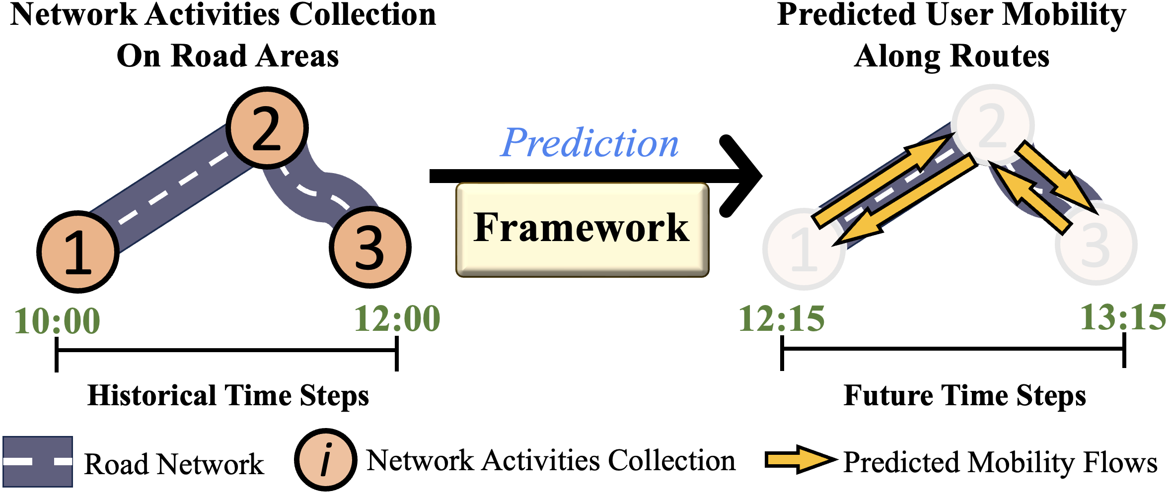
Enhancing Sustainable Urban Mobility Prediction with Telecom Data: A Spatio-Temporal Framework Approach
ChungYi Lin, Shen-Lung Tung, Hung-Ting Su, Winston H. Hsu
0
0
Traditional traffic prediction, limited by the scope of sensor data, falls short in comprehensive traffic management. Mobile networks offer a promising alternative using network activity counts, but these lack crucial directionality. Thus, we present the TeltoMob dataset, featuring undirected telecom counts and corresponding directional flows, to predict directional mobility flows on roadways. To address this, we propose a two-stage spatio-temporal graph neural network (STGNN) framework. The first stage uses a pre-trained STGNN to process telecom data, while the second stage integrates directional and geographic insights for accurate prediction. Our experiments demonstrate the framework's compatibility with various STGNN models and confirm its effectiveness. We also show how to incorporate the framework into real-world transportation systems, enhancing sustainable urban mobility.
5/29/2024
📊
Modeling Large-Scale Walking and Cycling Networks: A Machine Learning Approach Using Mobile Phone and Crowdsourced Data
Meead Saberi, Tanapon Lilasathapornkit
0
0
Walking and cycling are known to bring substantial health, environmental, and economic advantages. However, the development of evidence-based active transportation planning and policies has been impeded by significant data limitations, such as biases in crowdsourced data and representativeness issues of mobile phone data. In this study, we develop and apply a machine learning based modeling approach for estimating daily walking and cycling volumes across a large-scale regional network in New South Wales, Australia that includes 188,999 walking links and 114,885 cycling links. The modeling methodology leverages crowdsourced and mobile phone data as well as a range of other datasets on population, land use, topography, climate, etc. The study discusses the unique challenges and limitations related to all three aspects of model training, testing, and inference given the large geographical extent of the modeled networks and relative scarcity of observed walking and cycling count data. The study also proposes a new technique to identify model estimate outliers and to mitigate their impact. Overall, the study provides a valuable resource for transportation modelers, policymakers and urban planners seeking to enhance active transportation infrastructure planning and policies with advanced emerging data-driven modeling methodologies.
4/4/2024
🎲
Predicting Traffic Congestion at Urban Intersections Using Data-Driven Modeling
Tara Kelly, Jessica Gupta
0
0
Traffic congestion at intersections is a significant issue in urban areas, leading to increased commute times, safety hazards, and operational inefficiencies. This study aims to develop a predictive model for congestion at intersections in major U.S. cities, utilizing a dataset of trip-logging metrics from commercial vehicles across 4,800 intersections. The dataset encompasses 27 features, including intersection coordinates, street names, time of day, and traffic metrics (Kashyap et al., 2019). Additional features, such as rainfall/snowfall percentage, distance from downtown and outskirts, and road types, were incorporated to enhance the model's predictive power. The methodology involves data exploration, feature transformation, and handling missing values through low-rank models and label encoding. The proposed model has the potential to assist city planners and governments in anticipating traffic hot spots, optimizing operations, and identifying infrastructure challenges.
4/24/2024
Early Detection of Critical Urban Events using Mobile Phone Network Data
Pierre Lemaire, Angelo Furno, Stefania Rubrichi, Alexis Bondu, Zbigniew Smoreda, Cezary Ziemlicki, Nour-Eddin El Faouzi, Eric Gaume
0
0
Network Signalling Data (NSD) have the potential to provide continuous spatio-temporal information about the presence, mobility, and usage patterns of cell phone services by individuals. Such information is invaluable for monitoring large urban areas and supporting the implementation of decision-making services. When analyzed in real time, NSD can enable the early detection of critical urban events, including fires, large accidents, stampedes, terrorist attacks, and sports and leisure gatherings, especially if these events significantly impact mobile phone network activity in the affected areas. This paper presents empirical evidence that advanced NSD can detect anomalies in mobile traffic service consumption, attributable to critical urban events, with fine spatial and temporal resolutions. We introduce two methodologies for real-time anomaly detection from multivariate time series extracted from large-scale NSD, utilizing a range of algorithms adapted from the state-of-the-art in unsupervised machine learning techniques for anomaly detection. Our research includes a comprehensive quantitative evaluation of these algorithms on a large-scale dataset of NSD service consumption for the Paris region. The evaluation uses an original dataset of documented critical or unusual urban events. This dataset has been built as a ground truth basis for assessing the algorithms performance. The obtained results demonstrate that our framework can detect unusual events almost instantaneously and locate the affected areas with high precision, largely outperforming random classifiers. This efficiency and effectiveness underline the potential of NSD-based anomaly detection in significantly enhancing emergency response strategies and urban planning.
5/30/2024