Mesh-based Photorealistic and Real-time 3D Mapping for Robust Visual Perception of Autonomous Underwater Vehicle
2404.18395
0
0
Abstract
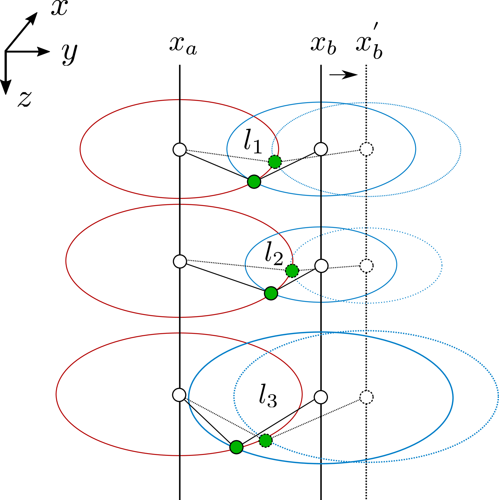
This paper proposes a photorealistic real-time dense 3D mapping system that utilizes a learning-based image enhancement method and mesh-based map representation. Due to the characteristics of the underwater environment, where problems such as hazing and low contrast occur, it is hard to apply conventional simultaneous localization and mapping (SLAM) methods. Furthermore, for sensitive tasks like inspecting cracks, photorealistic mapping is very important. However, the behavior of Autonomous Underwater Vehicle (AUV) is computationally constrained. In this paper, we utilize a neural network-based image enhancement method to improve pose estimation and mapping quality and apply a sliding window-based mesh expansion method to enable lightweight, fast, and photorealistic mapping. To validate our results, we utilize real-world and indoor synthetic datasets. We performed qualitative validation with the real-world dataset and quantitative validation by modeling images from the indoor synthetic dataset as underwater scenes.
Create account to get full access
Overview
- The paper presents a mesh-based approach for creating photorealistic and real-time 3D maps for robust visual perception of autonomous underwater vehicles (AUVs).
- The proposed method combines depth data from stereo cameras and color imagery to generate highly detailed 3D models of underwater environments in real-time.
- This allows AUVs to navigate and perceive their surroundings more effectively, which is crucial for tasks like underwater exploration, monitoring, and inspection.
Plain English Explanation
The researchers have developed a new way for autonomous underwater vehicles (AUVs) to build 3D maps of their underwater environment. Typically, AUVs use cameras and sensors to try to understand their surroundings, but this can be challenging in the murky, complex underwater world.
The key innovation in this paper is the use of a "mesh-based" approach. This means the 3D map is built up not just from individual points, but from a detailed, interconnected "mesh" of 3D data. The researchers combine depth information from stereo cameras with color imagery to create these high-fidelity 3D models in real-time as the AUV is moving.
This allows the AUV to perceive its environment much more accurately and robustly than previous methods. The photorealistic 3D maps can help the AUV navigate safely, identify objects and obstacles, and carry out tasks like underwater exploration, monitoring, and inspection more effectively. [Link to
Technical Explanation
The core of the researchers' approach is to fuse data from stereo cameras and color cameras to build a detailed 3D mesh representation of the underwater environment. The stereo cameras provide depth information, while the color cameras capture high-resolution imagery.
This depth and color data is then processed to generate a 3D triangle mesh that represents the underwater scene. The mesh is continuously updated in real-time as the AUV moves, allowing for a photorealistic and up-to-date 3D map. [Link to
Key technical innovations include:
- Efficient data fusion algorithms to combine depth and color data
- Real-time mesh generation and optimization techniques
- Robust tracking and localization to enable seamless 3D mapping
The resulting 3D maps provide the AUV with a highly detailed understanding of its surroundings, which is crucial for tasks like navigation, object recognition, and environmental monitoring. [Link to
Critical Analysis
The paper presents a compelling approach to 3D mapping for AUVs, with clear benefits in terms of improving their visual perception capabilities underwater. However, some potential limitations and areas for future work are worth considering:
The reliance on stereo cameras may limit the system's performance in low-visibility conditions or cluttered environments where obtaining reliable depth information is challenging. Incorporating additional sensor modalities, such as sonar or inertial measurement units, could help overcome these limitations. [Link to
Additionally, the computational requirements of the real-time mesh generation and optimization may be a concern for resource-constrained AUV platforms. Further research into efficient algorithms and hardware acceleration could help address this issue.
Finally, the authors do not provide extensive validation of the system's performance in real-world underwater scenarios. More comprehensive testing and benchmarking would help demonstrate the practical utility and robustness of the approach. [Link to
Conclusion
The proposed mesh-based approach for 3D mapping in autonomous underwater vehicles represents a significant advancement in the field of underwater visual perception. By combining depth and color data to generate photorealistic 3D models in real-time, the system can greatly enhance an AUV's ability to navigate, perceive, and interact with its underwater environment.
This technology has the potential to unlock new capabilities for AUVs in a wide range of applications, from underwater exploration and monitoring to inspection and maintenance tasks. As the researchers continue to refine and validate their approach, it could become a valuable tool for advancing the state of the art in autonomous underwater robotics. [Link to
This summary was produced with help from an AI and may contain inaccuracies - check out the links to read the original source documents!
Related Papers
🤿
A Sonar-based AUV Positioning System for Underwater Environments with Low Infrastructure Density
Emilio Olivastri, Daniel Fusaro, Wanmeng Li, Simone Mosco, Alberto Pretto
0
0
The increasing demand for underwater vehicles highlights the necessity for robust localization solutions in inspection missions. In this work, we present a novel real-time sonar-based underwater global positioning algorithm for AUVs (Autonomous Underwater Vehicles) designed for environments with a sparse distribution of human-made assets. Our approach exploits two synergistic data interpretation frontends applied to the same stream of sonar data acquired by a multibeam Forward-Looking Sonar (FSD). These observations are fused within a Particle Filter (PF) either to weigh more particles that belong to high-likelihood regions or to solve symmetric ambiguities. Preliminary experiments carried out on a simulated environment resembling a real underwater plant provided promising results. This work represents a starting point towards future developments of the method and consequent exhaustive evaluations also in real-world scenarios.
5/6/2024
NeuRSS: Enhancing AUV Localization and Bathymetric Mapping with Neural Rendering for Sidescan SLAM
Yiping Xie, Jun Zhang, Nils Bore, John Folkesson
0
0
Implicit neural representations and neural render- ing have gained increasing attention for bathymetry estimation from sidescan sonar (SSS). These methods incorporate multiple observations of the same place from SSS data to constrain the elevation estimate, converging to a globally-consistent bathymetric model. However, the quality and precision of the bathymetric estimate are limited by the positioning accuracy of the autonomous underwater vehicle (AUV) equipped with the sonar. The global positioning estimate of the AUV relying on dead reckoning (DR) has an unbounded error due to the absence of a geo-reference system like GPS underwater. To address this challenge, we propose in this letter a modern and scalable framework, NeuRSS, for SSS SLAM based on DR and loop closures (LCs) over large timescales, with an elevation prior provided by the bathymetric estimate using neural rendering from SSS. This framework is an iterative procedure that improves localization and bathymetric mapping. Initially, the bathymetry estimated from SSS using the DR estimate, though crude, can provide an important elevation prior in the nonlinear least-squares (NLS) optimization that estimates the relative pose between two loop-closure vertices in a pose graph. Subsequently, the global pose estimate from the SLAM component improves the positioning estimate of the vehicle, thus improving the bathymetry estimation. We validate our localization and mapping approach on two large surveys collected with a surface vessel and an AUV, respectively. We evaluate their localization results against the ground truth and compare the bathymetry estimation against data collected with multibeam echo sounders (MBES).
5/10/2024

Multi-AUV Cooperative Underwater Multi-Target Tracking Based on Dynamic-Switching-enabled Multi-Agent Reinforcement Learning
Shengbo Wang, Chuan Lin, Guangjie Han, Shengchao Zhu, Zhixian Li, Zhenyu Wang
0
0
With the rapid development of underwater communication, sensing, automation, robot technologies, autonomous underwater vehicle (AUV) swarms are gradually becoming popular and have been widely promoted in ocean exploration and underwater tracking or surveillance, etc. However, the complex underwater environment poses significant challenges for AUV swarm-based accurate tracking for the underwater moving targets. In this paper, we aim at proposing a multi-AUV cooperative underwater multi-target tracking algorithm especially when the real underwater factors are taken into account.We first give normally modelling approach for the underwater sonar-based detection and the ocean current interference on the target tracking process.Then, we regard the AUV swarm as a underwater ad-hoc network and propose a novel Multi-Agent Reinforcement Learning (MARL) architecture towards the AUV swarm based on Software-Defined Networking (SDN).It enhances the flexibility and scalability of the AUV swarm through centralized management and distributed operations.Based on the proposed MARL architecture, we propose the dynamic-attention switching and dynamic-resampling switching mechanisms, to enhance the efficiency and accuracy of AUV swarm cooperation during task execution.Finally, based on a proposed AUV classification method, we propose an efficient cooperative tracking algorithm called ASMA.Evaluation results demonstrate that our proposed tracking algorithm can perform precise underwater multi-target tracking, comparing with many of recent research products in terms of convergence speed and tracking accuracy.
4/24/2024

On-board classification of underwater images using hybrid classical-quantum CNN based method
Sreeraj Rajan Warrier, D Sri Harshavardhan Reddy, Sriya Bada, Rohith Achampeta, Sebastian Uppapalli, Jayasri Dontabhaktuni
0
0
Underwater images taken from autonomous underwater vehicles (AUV's) often suffer from low light, high turbidity, poor contrast, motion-blur and excessive light scattering and hence require image enhancement techniques for object recognition. Machine learning methods are being increasingly used for object recognition under such adverse conditions. These enhanced object recognition methods of images taken from AUV's has potential applications in underwater pipeline and optical fibre surveillance, ocean bed resource extraction, ocean floor mapping, underwater species exploration, etc. While the classical machine learning methods are very efficient in terms of accuracy, they require large datasets and high computational time for image classification. In the current work, we use quantum-classical hybrid machine learning methods for real-time under-water object recognition on-board an AUV for the first time. We use real-time motion-blurred and low-light images taken from an on-board camera of AUV built in-house and apply existing hybrid machine learning methods for object recognition. Our hybrid methods consist of quantum encoding and flattening of classical images using quantum circuits and sending them to classical neural networks for image classification. The results of hybrid methods carried out using Pennylane based quantum simulators both on GPU and using pre-trained models on an on-board NVIDIA GPU chipset are compared with results from corresponding classical machine learning methods. We observe that the hybrid quantum machine learning methods show an efficiency greater than 65% and reduction in run-time by one-thirds and require 50% smaller dataset sizes for training the models compared to classical machine learning methods. We hope that our work opens up further possibilities in quantum enhanced real-time computer vision in autonomous vehicles.
4/23/2024