Deep Vision-Based Framework for Coastal Flood Prediction Under Climate Change Impacts and Shoreline Adaptations

0
Sign in to get full access
Overview
• This research paper presents a deep vision-based framework for predicting coastal flooding under the impacts of climate change and shoreline adaptations.
• The framework utilizes advanced computer vision techniques, such as Convolutional Neural Networks (CNNs) and Long Short-Term Memory (LSTMs), to analyze satellite and aerial imagery data and forecast future flood events.
• The researchers aim to provide a comprehensive tool for coastal communities to plan and adapt to the increasing risks posed by climate change-driven sea level rise and extreme weather events.
Plain English Explanation
The research paper describes a new system that uses advanced computer vision and deep learning techniques to predict coastal flooding. The system analyzes satellite and aerial images to understand current and future flood risks due to climate change, such as rising sea levels and more frequent extreme weather events.
The key idea is to use powerful Convolutional Neural Networks (CNNs) and Long Short-Term Memory (LSTMs) models to automatically process and interpret the visual data. This allows the system to identify patterns and make predictions about future flood levels and inundation areas.
The ultimate goal is to provide a comprehensive tool that can help coastal communities plan for and adapt to the growing risks posed by climate change. By having a better understanding of future flood threats, local authorities and residents can make more informed decisions about infrastructure, emergency planning, and other adaptation measures.
Technical Explanation
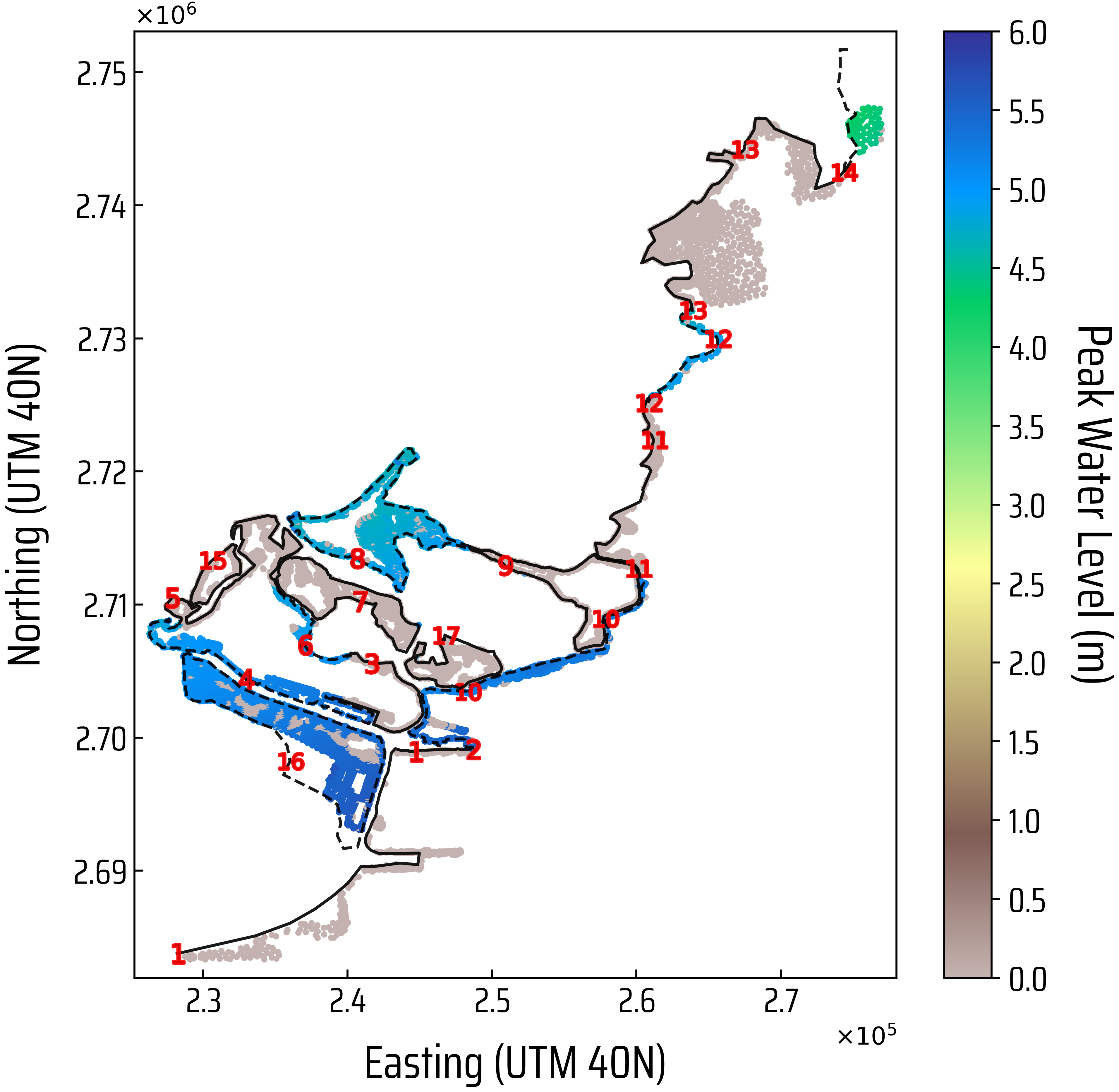
The research paper presents a deep vision-based framework for predicting coastal flooding under the impacts of climate change and various shoreline adaptation strategies. The core of the framework is a Convolutional Neural Network (CNN) model that analyzes satellite and aerial imagery data to extract relevant features for flood forecasting.
To capture the temporal dynamics of coastal flooding, the researchers also incorporate Long Short-Term Memory (LSTM) modules into the model architecture. This allows the framework to learn patterns and make predictions based on historical data and future climate projections.
The framework is designed to be flexible and adaptable, enabling the integration of various data sources, including bathymetry, tidal information, and weather data. This allows the system to provide more accurate and reliable flood forecasts, accounting for the complex interactions between climate change, coastal processes, and human interventions.
Critical Analysis
The research paper presents a comprehensive and innovative approach to coastal flood prediction, leveraging the power of deep vision-based techniques. The incorporation of Convolutional Neural Networks (CNNs) and Long Short-Term Memory (LSTMs) is a promising step towards developing more accurate and dynamic flood forecasting models.
However, the paper acknowledges several limitations and areas for further research. The framework's reliance on satellite and aerial imagery data may be constrained by data availability, resolution, and cloud coverage, which could impact the model's performance in certain regions. Additionally, the integration of other data sources, such as streamflow predictions and underwater transmission loss, could further enhance the model's ability to capture the complex coastal dynamics.
The researchers also highlight the need for continued validation and testing of the framework in diverse coastal environments, considering factors such as tropical Pacific ocean reconstruction, to ensure its robustness and generalizability.
Conclusion
The deep vision-based framework presented in this research paper represents a significant advancement in coastal flood prediction, addressing the growing challenges posed by climate change. By leveraging the power of Convolutional Neural Networks (CNNs) and Long Short-Term Memory (LSTMs), the system can analyze satellite and aerial imagery to forecast future flood events and guide coastal communities in their adaptation strategies.
The framework's flexibility and the potential for integrating diverse data sources suggest a promising path towards more comprehensive and accurate flood prediction models. As coastal regions face increasing risks from climate change, tools like this can play a vital role in helping communities plan, prepare, and build resilience to the impacts of rising sea levels and extreme weather events.
This summary was produced with help from an AI and may contain inaccuracies - check out the links to read the original source documents!
Related Papers
0
Deep Vision-Based Framework for Coastal Flood Prediction Under Climate Change Impacts and Shoreline Adaptations
Areg Karapetyan, Aaron Chung Hin Chow, Samer Madanat
In light of growing threats posed by climate change in general and sea level rise (SLR) in particular, the necessity for computationally efficient means to estimate and analyze potential coastal flood hazards has become increasingly pressing. Data-driven supervised learning methods serve as promising candidates that can dramatically expedite the process, thereby eliminating the computational bottleneck associated with traditional physics-based hydrodynamic simulators. Yet, the development of accurate and reliable coastal flood prediction models, especially those based on Deep Learning (DL) techniques, has been plagued with two major issues: (1) the scarcity of training data and (2) the high-dimensional output required for detailed inundation mapping. To remove this barrier, we present a systematic framework for training high-fidelity Deep Vision-based coastal flood prediction models in low-data settings. We test the proposed workflow on different existing vision models, including a fully transformer-based architecture and a Convolutional Neural Network (CNN) with additive attention gates. Additionally, we introduce a deep CNN architecture tailored specifically to the coastal flood prediction problem at hand. The model was designed with a particular focus on its compactness so as to cater to resource-constrained scenarios and accessibility aspects. The performance of the developed DL models is validated against commonly adopted geostatistical regression methods and traditional Machine Learning (ML) approaches, demonstrating substantial improvement in prediction quality. Lastly, we round up the contributions by providing a meticulously curated dataset of synthetic flood inundation maps of Abu Dhabi's coast produced with a physics-based hydrodynamic simulator, which can serve as a benchmark for evaluating future coastal flood prediction models.
Read more6/26/2024

0
Evaluation of deep learning models for Australian climate extremes: prediction of streamflow and floods
Siddharth Khedkar, R. Willem Vervoort, Rohitash Chandra
In recent years, climate extremes such as floods have created significant environmental and economic hazards for Australia, causing damage to the environment and economy and losses of human and animal lives. An efficient method of forecasting floods is crucial to limit this damage. Techniques for flood prediction are currently based on hydrological, and hydrodynamic (physically-based) numerical models. Machine learning methods that include deep learning offer certain advantages over conventional physically based approaches, including flexibility and accuracy. Deep learning methods have been promising for predicting small to medium-sized climate extreme events over a short time horizon; however, large flooding events present a critical challenge. We present an ensemble-based machine learning approach that addresses large-scale extreme flooding challenges using a switching mechanism motivated by extreme-value theory for long-short-term-memory (LSTM) deep learning models. We use a multivariate and multi-step time-series prediction approach to predict streamflow for multiple days ahead in the major catchments of Australia. The ensemble framework also employs static information to enrich the time-series information, allowing for regional modelling across catchments. Our results demonstrate enhanced prediction of streamflow extremes, with notable efficacy for large flooding scenarios in the selected Australian catchments. Through comparative analysis, our methodology underscores the potential for deep learning models to revolutionise flood forecasting across diverse regions.
Read more7/24/2024

0
Application of Long-Short Term Memory and Convolutional Neural Networks for Real-Time Bridge Scour Forecast
Tahrima Hashem, Negin Yousefpour
Scour around bridge piers is a critical challenge for infrastructures around the world. In the absence of analytical models and due to the complexity of the scour process, it is difficult for current empirical methods to achieve accurate predictions. In this paper, we exploit the power of deep learning algorithms to forecast the scour depth variations around bridge piers based on historical sensor monitoring data, including riverbed elevation, flow elevation, and flow velocity. We investigated the performance of Long Short-Term Memory (LSTM) and Convolutional Neural Network (CNN) models for real-time scour forecasting using data collected from bridges in Alaska and Oregon from 2006 to 2021. The LSTM models achieved mean absolute error (MAE) ranging from 0.1m to 0.5m for predicting bed level variations a week in advance, showing a reasonable performance. The Fully Convolutional Network (FCN) variant of CNN outperformed other CNN configurations, showing a comparable performance to LSTMs with significantly lower computational costs. We explored various innovative random-search heuristics for hyperparameter tuning and model optimisation which resulted in reduced computational cost compared to grid-search method. The impact of different combinations of sensor features on scour prediction showed the significance of the historical time series of scour for predicting upcoming events. Overall, this study provides a greater understanding of the potential of Deep Learning algorithms for real-time scour prediction and early warning for bridges with distinct geology, geomorphology and flow characteristics.
Read more5/6/2024
0
DeepDamageNet: A two-step deep-learning model for multi-disaster building damage segmentation and classification using satellite imagery
Irene Alisjahbana (Mullet), Jiawei Li (Mullet), Ben (Mullet), Strong, Yue Zhang
Satellite imagery has played an increasingly important role in post-disaster building damage assessment. Unfortunately, current methods still rely on manual visual interpretation, which is often time-consuming and can cause very low accuracy. To address the limitations of manual interpretation, there has been a significant increase in efforts to automate the process. We present a solution that performs the two most important tasks in building damage assessment, segmentation and classification, through deep-learning models. We show our results submitted as part of the xView2 Challenge, a competition to design better models for identifying buildings and their damage level after exposure to multiple kinds of natural disasters. Our best model couples a building identification semantic segmentation convolutional neural network (CNN) to a building damage classification CNN, with a combined F1 score of 0.66, surpassing the xView2 challenge baseline F1 score of 0.28. We find that though our model was able to identify buildings with relatively high accuracy, building damage classification across various disaster types is a difficult task due to the visual similarity between different damage levels and different damage distribution between disaster types, highlighting the fact that it may be important to have a probabilistic prior estimate regarding disaster damage in order to obtain accurate predictions.
Read more5/9/2024