DiffusionSat: A Generative Foundation Model for Satellite Imagery
2312.03606
0
0
Abstract
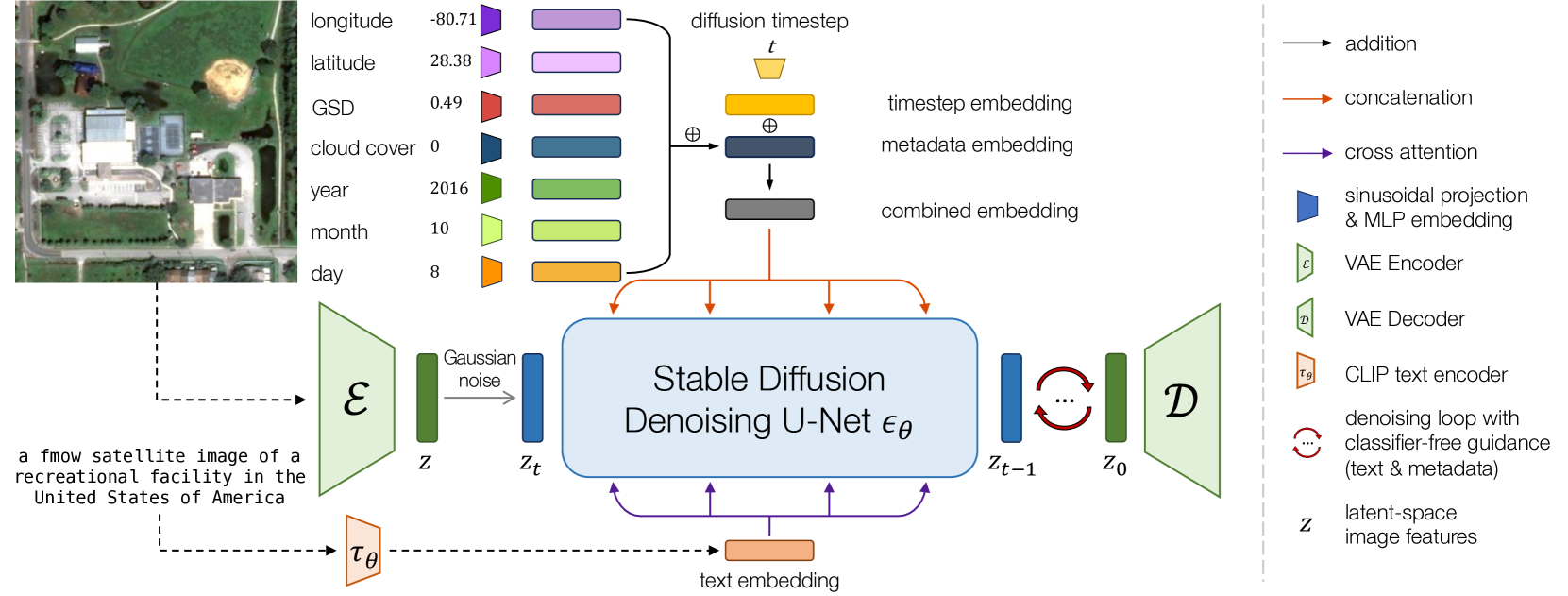
Diffusion models have achieved state-of-the-art results on many modalities including images, speech, and video. However, existing models are not tailored to support remote sensing data, which is widely used in important applications including environmental monitoring and crop-yield prediction. Satellite images are significantly different from natural images -- they can be multi-spectral, irregularly sampled across time -- and existing diffusion models trained on images from the Web do not support them. Furthermore, remote sensing data is inherently spatio-temporal, requiring conditional generation tasks not supported by traditional methods based on captions or images. In this paper, we present DiffusionSat, to date the largest generative foundation model trained on a collection of publicly available large, high-resolution remote sensing datasets. As text-based captions are sparsely available for satellite images, we incorporate the associated metadata such as geolocation as conditioning information. Our method produces realistic samples and can be used to solve multiple generative tasks including temporal generation, superresolution given multi-spectral inputs and in-painting. Our method outperforms previous state-of-the-art methods for satellite image generation and is the first large-scale generative foundation model for satellite imagery. The project website can be found here: https://samar-khanna.github.io/DiffusionSat/
Create account to get full access
Overview
- This paper introduces DiffusionSat, a new generative foundation model for satellite imagery.
- The model uses diffusion models, a type of machine learning technique, to generate high-quality synthetic satellite images.
- The authors demonstrate the model's capabilities on a range of remote sensing tasks, including image generation, super-resolution, and semantic segmentation.
Plain English Explanation
DiffusionSat is a new AI model that can generate realistic-looking satellite images from scratch. It works by learning the patterns and structure of real satellite imagery, and then using that knowledge to create new, synthetic images that look just like the real thing.
The key innovation in DiffusionSat is the use of "diffusion models", a type of machine learning technique that has shown great promise for generating high-quality images. Diffusion models work by starting with random noise and gradually transforming it into more and more realistic-looking images, following a process that mimics the physical concept of diffusion.
By leveraging diffusion models, the researchers were able to build a system that can not only generate new satellite images, but also perform other useful tasks like improving the resolution of existing images or identifying different features and objects in the imagery. This makes DiffusionSat a powerful tool for a variety of remote sensing applications, from urban planning to agricultural monitoring.
Technical Explanation
DiffusionSat is a generative foundation model for satellite imagery that uses diffusion models to generate high-quality synthetic images. Diffusion models work by gradually transforming random noise into realistic-looking images, following a process inspired by the physical phenomenon of diffusion.
The authors train DiffusionSat on a large dataset of satellite imagery, allowing the model to learn the underlying patterns and structures of real satellite data. This learned knowledge is then used to generate new, synthetic images that are visually indistinguishable from the real thing.
Beyond just image generation, the researchers also demonstrate DiffusionSat's capabilities on a range of remote sensing tasks, including super-resolution to enhance the resolution of existing images, and semantic segmentation to identify different features and objects within the imagery.
The results show that DiffusionSat outperforms previous state-of-the-art models on these tasks, highlighting the potential of diffusion-based approaches for remote sensing applications.
Critical Analysis
The authors of the DiffusionSat paper make a compelling case for the potential of diffusion models in remote sensing, demonstrating impressive results on a variety of tasks. However, the paper does acknowledge some limitations of the current approach.
One key limitation is the computational cost and training time required for diffusion models, which can be significantly higher than other types of generative models. This may limit the practical applications of DiffusionSat, especially for real-time or resource-constrained scenarios.
Additionally, the paper does not address the potential for bias or errors in the generated satellite images, which could be a concern for mission-critical applications. Further research is needed to understand the robustness and reliability of diffusion-based models in remote sensing.
Overall, while DiffusionSat represents an exciting development in the field of satellite imagery analysis, additional work is needed to fully address the practical challenges and potential pitfalls of this approach.
Conclusion
DiffusionSat is a promising new generative foundation model that demonstrates the potential of diffusion-based approaches for remote sensing applications. By leveraging the power of diffusion models, the researchers have shown that it is possible to generate high-quality synthetic satellite images and perform a range of other useful tasks, from super-resolution to semantic segmentation.
While the current implementation of DiffusionSat has some limitations, the overall approach holds great promise for advancing the field of satellite imagery analysis and opening up new possibilities for applications such as urban planning, environmental monitoring, and disaster response. As the technology continues to evolve, we can expect to see even more impressive and impactful applications of diffusion-based models in the remote sensing domain.
This summary was produced with help from an AI and may contain inaccuracies - check out the links to read the original source documents!
Related Papers
Remote Diffusion
Kunal Sunil Kasodekar
0
0
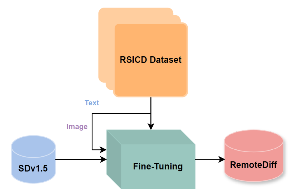
I explored adapting Stable Diffusion v1.5 for generating domain-specific satellite and aerial images in remote sensing. Recognizing the limitations of existing models like Midjourney and Stable Diffusion, trained primarily on natural RGB images and lacking context for remote sensing, I used the RSICD dataset to train a Stable Diffusion model with a loss of 0.2. I incorporated descriptive captions from the dataset for text-conditioning. Additionally, I created a synthetic dataset for a Land Use Land Classification (LULC) task, employing prompting techniques with RAG and ChatGPT and fine-tuning a specialized remote sensing LLM. However, I faced challenges with prompt quality and model performance. I trained a classification model (ResNet18) on the synthetic dataset achieving 49.48% test accuracy in TorchGeo to create a baseline. Quantitative evaluation through FID scores and qualitative feedback from domain experts assessed the realism and quality of the generated images and dataset. Despite extensive fine-tuning and dataset iterations, results indicated subpar image quality and realism, as indicated by high FID scores and domain-expert evaluation. These findings call attention to the potential of diffusion models in remote sensing while highlighting significant challenges related to insufficient pretraining data and computational resources.
5/9/2024
Diffusion Models Meet Remote Sensing: Principles, Methods, and Perspectives
Yidan Liu, Jun Yue, Shaobo Xia, Pedram Ghamisi, Weiying Xie, Leyuan Fang
0
0
As a newly emerging advance in deep generative models, diffusion models have achieved state-of-the-art results in many fields, including computer vision, natural language processing, and molecule design. The remote sensing community has also noticed the powerful ability of diffusion models and quickly applied them to a variety of tasks for image processing. Given the rapid increase in research on diffusion models in the field of remote sensing, it is necessary to conduct a comprehensive review of existing diffusion model-based remote sensing papers, to help researchers recognize the potential of diffusion models and provide some directions for further exploration. Specifically, this paper first introduces the theoretical background of diffusion models, and then systematically reviews the applications of diffusion models in remote sensing, including image generation, enhancement, and interpretation. Finally, the limitations of existing remote sensing diffusion models and worthy research directions for further exploration are discussed and summarized.
4/16/2024
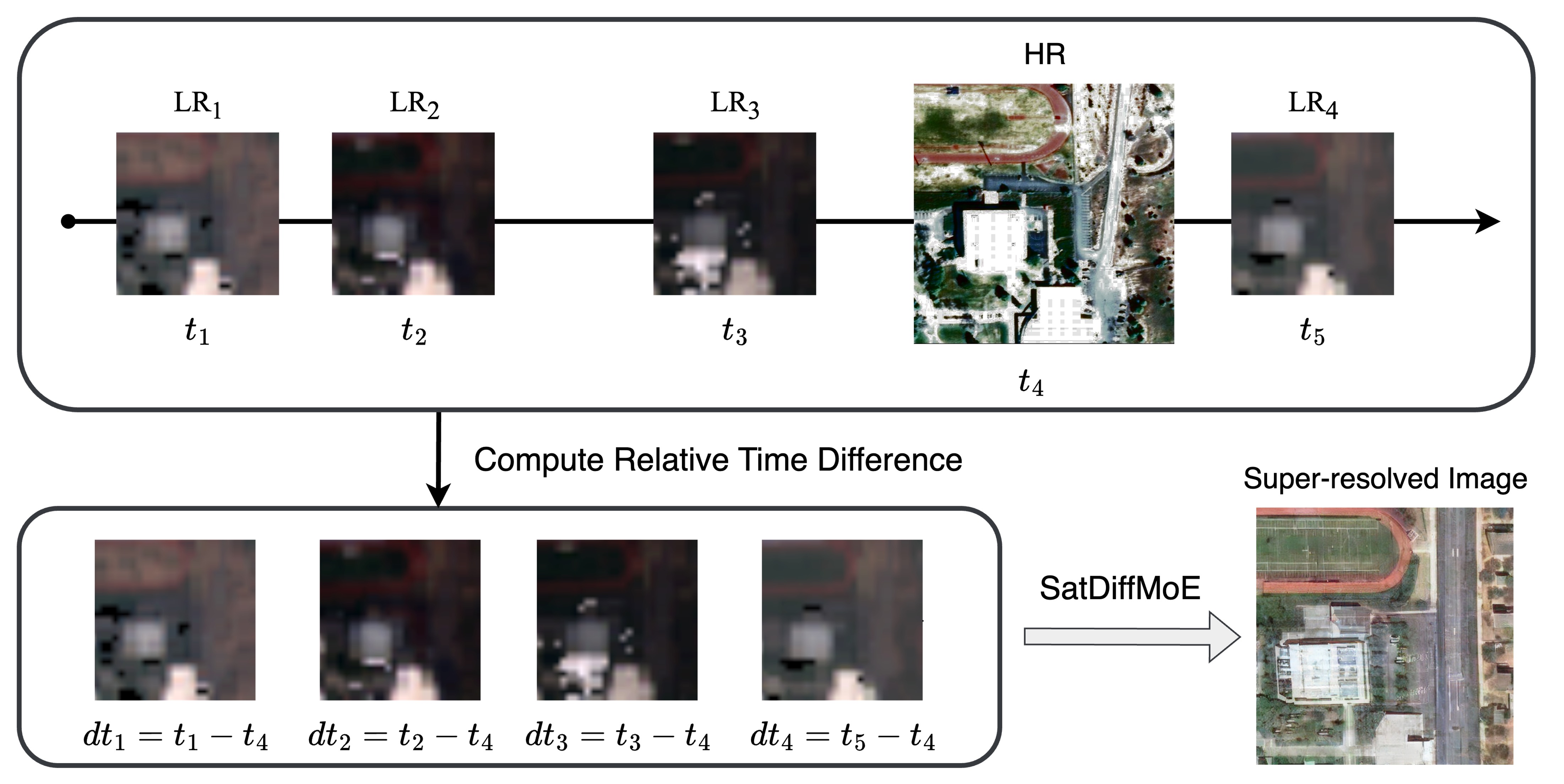
SatDiffMoE: A Mixture of Estimation Method for Satellite Image Super-resolution with Latent Diffusion Models
Zhaoxu Luo, Bowen Song, Liyue Shen
0
0
During the acquisition of satellite images, there is generally a trade-off between spatial resolution and temporal resolution (acquisition frequency) due to the onboard sensors of satellite imaging systems. High-resolution satellite images are very important for land crop monitoring, urban planning, wildfire management and a variety of applications. It is a significant yet challenging task to achieve high spatial-temporal resolution in satellite imaging. With the advent of diffusion models, we can now learn strong generative priors to generate realistic satellite images with high resolution, which can be utilized to promote the super-resolution task as well. In this work, we propose a novel diffusion-based fusion algorithm called textbf{SatDiffMoE} that can take an arbitrary number of sequential low-resolution satellite images at the same location as inputs, and fuse them into one high-resolution reconstructed image with more fine details, by leveraging and fusing the complementary information from different time points. Our algorithm is highly flexible and allows training and inference on arbitrary number of low-resolution images. Experimental results show that our proposed SatDiffMoE method not only achieves superior performance for the satellite image super-resolution tasks on a variety of datasets, but also gets an improved computational efficiency with reduced model parameters, compared with previous methods.
6/17/2024

CRS-Diff: Controllable Generative Remote Sensing Foundation Model
Datao Tang, Xiangyong Cao, Xingsong Hou, Zhongyuan Jiang, Deyu Meng
0
0
The emergence of generative models has revolutionized the field of remote sensing (RS) image generation. Despite generating high-quality images, existing methods are limited in relying mainly on text control conditions and thus don't always generate images accurately and stablely. In this paper, we propose CRS-Diff, a new RS generative foundation framework specifically tailored for RS image generation, leveraging the inherent advantages of diffusion models while integrating more advanced control mechanisms. Specifically, CRS-Diff can simultaneously support text-condition, metadata-condition, and image-condition control inputs, thus enabling more precise control to refine the generation process. To effectively integrate multiple condition control information, we introduce a new conditional control mechanism to achieve multi-scale feature fusion, thus enhancing the guiding effect of control conditions. To our knowledge, CRS-Diff is the first multiple-condition controllable generative RS foundation model. Experimental results in single-condition and multiple-condition cases have demonstrated the superior ability of our CRS-Diff to generate RS images both quantitatively and qualitatively compared with previous methods. Additionally, our CRS-Diff can serve as a data engine that generates high-quality training data for downstream tasks, e.g., road extraction. The code is available at https://github.com/Sonettoo/CRS-Diff.
6/12/2024