An evaluation of CFEAR Radar Odometry
2404.01781
0
0

Abstract
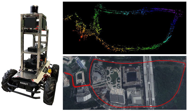
This article describes the method CFEAR Radar odometry, submitted to a competition at the Radar in Robotics workshop, ICRA 20241. CFEAR is an efficient and accurate method for spinning 2D radar odometry that generalizes well across environments. This article presents an overview of the odometry pipeline with new experiments on the public Boreas dataset. We show that a real-time capable configuration of CFEAR - with its original parameter set - yields surprisingly low drift in the Boreas dataset. Additionally, we discuss an improved implementation and solving strategy that enables the most accurate configuration to run in real-time with improved robustness, reaching as low as 0.61% translation drift at a frame rate of 68 Hz. A recent release of the source code is available to the community https://github.com/dan11003/CFEAR_Radarodometry_code_public, and we publish the evaluation from this article on https://github.com/dan11003/cfear_2024_workshop
Create account to get full access
Overview
- This paper presents a new method for radar odometry, which is the process of estimating the motion of a robot or vehicle using radar data.
- The key innovation is the use of "oriented surface points" to improve the efficiency and accuracy of radar odometry.
- The method is evaluated on several real-world datasets and shows significant improvements in tracking performance compared to existing approaches.
Plain English Explanation
The paper focuses on a challenge faced by robots and self-driving vehicles that use radar sensors to understand their surroundings and navigate. Radar odometry is the process of using radar data to estimate the motion and position of the vehicle over time. However, traditional radar odometry methods have limitations in terms of efficiency and accuracy.
The researchers developed a new approach that uses "oriented surface points" to represent the environment detected by the radar. Instead of just using the raw radar measurements, their method analyzes the radar data to identify key features in the environment, such as walls, objects, or the ground. It then uses the orientation and position of these features to more precisely track the vehicle's movement.
Imagine you're driving a car and using radar to "see" the world around you. Traditional radar odometry would just track the raw radar reflections, which can be noisy and inconsistent. The new method is more like your brain - it recognizes important landmarks like buildings or road edges, and uses those stable features to figure out how the car is moving. This makes the motion tracking much more reliable and accurate.
The researchers tested their approach on several different real-world datasets, showing that it outperforms existing radar odometry methods in terms of tracking performance. This suggests the new technique could be very useful for robots, self-driving cars, and other applications that rely on radar to understand their surroundings and navigate.
Technical Explanation
The key innovation in this paper is the use of "oriented surface points" (OSPs) to represent the environment observed by the radar sensor. Traditional radar odometry approaches rely on directly matching consecutive radar point clouds, which can be challenging due to sensor noise, dynamic obstacles, and occlusions.
Instead, the proposed method first identifies stable surface features in the radar data, such as walls, floors, and other static objects. It then tracks the position and orientation of these OSPs over time to estimate the egomotion (self-motion) of the vehicle. Specifically, the pipeline consists of the following steps:
- Preprocessing: The raw radar data is filtered and segmented to extract potential surface features.
- OSP extraction: The segmented regions are analyzed to fit planar surface models, extracting the position and normal vector for each OSP.
- Data association: Corresponding OSPs are matched between consecutive scans using a combination of geometric and appearance-based features.
- Odometry estimation: The OSP correspondences are used to estimate the 6-DoF pose change of the vehicle using a point-to-plane ICP algorithm.
The authors evaluate their approach on several public radar datasets, including both indoor and outdoor environments. The results show significant improvements in tracking accuracy and robustness compared to baseline radar odometry methods that rely on raw point clouds or hand-crafted geometric features.
Critical Analysis
The core contribution of this work is the introduction of the oriented surface points (OSP) representation, which effectively leverages the structured nature of radar data to improve odometry estimation. By focusing on stable surface features rather than raw points, the method is more resilient to sensor noise, dynamic obstacles, and occlusions.
That said, the paper does not address some important practical considerations. For example, the current implementation assumes the availability of accurate surface normal information, which may not always be the case in real-world scenarios. Additionally, the computational cost of the OSP extraction and data association steps could limit the real-time performance, especially for resource-constrained embedded systems.
Further research is needed to explore ways of reducing the algorithmic complexity and relaxing the assumptions around surface normal estimation. Validating the approach on a wider range of radar hardware and environments would also help to demonstrate its generalizability.
Overall, this work represents a promising step forward in leveraging the unique properties of radar data for robust localization and mapping. The OSP-based odometry technique could have significant impact in applications like autonomous navigation, where reliable motion estimation is a crucial capability.
Conclusion
This paper introduces a novel radar odometry method that utilizes oriented surface points to achieve efficient and accurate vehicle pose estimation. By focusing on stable environmental features rather than raw sensor data, the proposed approach demonstrates superior tracking performance compared to existing techniques.
The key innovation of the OSP representation and the associated data processing pipeline opens up new avenues for radar-based perception and navigation. While some practical challenges remain, this work lays the groundwork for developing more robust and reliable radar-centric algorithms for robotics and autonomous systems. As radar hardware continues to evolve, methods like the one presented here will become increasingly valuable for applications that require efficient and accurate localization in complex, dynamic environments.
This summary was produced with help from an AI and may contain inaccuracies - check out the links to read the original source documents!
Related Papers
EFEAR-4D: Ego-Velocity Filtering for Efficient and Accurate 4D radar Odometry
Xiaoyi Wu, Yushuai Chen, Zhan Li, Ziyang Hong, Liang Hu
0
0
Odometry is a crucial component for successfully implementing autonomous navigation, relying on sensors such as cameras, LiDARs and IMUs. However, these sensors may encounter challenges in extreme weather conditions, such as snowfall and fog. The emergence of FMCW radar technology offers the potential for robust perception in adverse conditions. As the latest generation of FWCW radars, the 4D mmWave radar provides point cloud with range, azimuth, elevation, and Doppler velocity information, despite inherent sparsity and noises in the point cloud. In this paper, we propose EFEAR-4D, an accurate, highly efficient, and learning-free method for large-scale 4D radar odometry estimation. EFEAR-4D exploits Doppler velocity information delicately for robust ego-velocity estimation, resulting in a highly accurate prior guess. EFEAR-4D maintains robustness against point-cloud sparsity and noises across diverse environments through dynamic object removal and effective region-wise feature extraction. Extensive experiments on two publicly available 4D radar datasets demonstrate state-of-the-art reliability and localization accuracy of EFEAR-4D under various conditions. Furthermore, we have collected a dataset following the same route but varying installation heights of the 4D radar, emphasizing the significant impact of radar height on point cloud quality - a crucial consideration for real-world deployments. Our algorithm and dataset will be available soon at https://github.com/CLASS-Lab/EFEAR-4D.
5/17/2024
📶
Advancements in Radar Odometry
Matteo Frosi, Mirko Usuelli, Matteo Matteucci
0
0
Radar odometry estimation has emerged as a critical technique in the field of autonomous navigation, providing robust and reliable motion estimation under various environmental conditions. Despite its potential, the complex nature of radar signals and the inherent challenges associated with processing these signals have limited the widespread adoption of this technology. This paper aims to address these challenges by proposing novel improvements to an existing method for radar odometry estimation, designed to enhance accuracy and reliability in diverse scenarios. Our pipeline consists of filtering, motion compensation, oriented surface points computation, smoothing, one-to-many radar scan registration, and pose refinement. The developed method enforces local understanding of the scene, by adding additional information through smoothing techniques, and alignment of consecutive scans, as a refinement posterior to the one-to-many registration. We present an in-depth investigation of the contribution of each improvement to the localization accuracy, and we benchmark our system on the sequences of the main datasets for radar understanding, i.e., the Oxford Radar RobotCar, MulRan, and Boreas datasets. The proposed pipeline is able to achieve superior results, on all scenarios considered and under harsh environmental constraints.
4/8/2024
🎲
Radarize: Enhancing Radar SLAM with Generalizable Doppler-Based Odometry
Emerson Sie, Xinyu Wu, Heyu Guo, Deepak Vasisht
0
0
Millimeter-wave (mmWave) radar is increasingly being considered as an alternative to optical sensors for robotic primitives like simultaneous localization and mapping (SLAM). While mmWave radar overcomes some limitations of optical sensors, such as occlusions, poor lighting conditions, and privacy concerns, it also faces unique challenges, such as missed obstacles due to specular reflections or fake objects due to multipath. To address these challenges, we propose Radarize, a self-contained SLAM pipeline that uses only a commodity single-chip mmWave radar. Our radar-native approach uses techniques such as Doppler shift-based odometry and multipath artifact suppression to improve performance. We evaluate our method on a large dataset of 146 trajectories spanning 4 buildings and mounted on 3 different platforms, totaling approximately 4.7 Km of travel distance. Our results show that our method outperforms state-of-the-art radar and radar-inertial approaches by approximately 5x in terms of odometry and 8x in terms of end-to-end SLAM, as measured by absolute trajectory error (ATE), without the need for additional sensors such as IMUs or wheel encoders.
4/30/2024
RAVE: A Framework for Radar Ego-Velocity Estimation
Vlaho-Josip v{S}tironja, Luka Petrovi'c, Juraj Perv{s}i'c, Ivan Markovi'c, Ivan Petrovi'c
0
0
State estimation is an essential component of autonomous systems, usually relying on sensor fusion that integrates data from cameras, LiDARs and IMUs. Recently, radars have shown the potential to improve the accuracy and robustness of state estimation and perception, especially in challenging environmental conditions such as adverse weather and low-light scenarios. In this paper, we present a framework for ego-velocity estimation, which we call RAVE, that relies on 3D automotive radar data and encompasses zero velocity detection, outlier rejection, and velocity estimation. In addition, we propose a simple filtering method to discard infeasible ego-velocity estimates. We also conduct a systematic analysis of how different existing outlier rejection techniques and optimization loss functions impact estimation accuracy. Our evaluation on three open-source datasets demonstrates the effectiveness of the proposed filter and a significant positive impact of RAVE on the odometry accuracy. Furthermore, we release an open-source implementation of the proposed framework for radar ego-velocity estimation accompanied with a ROS interface.
6/28/2024