Advancements in Radar Odometry
2310.12729
0
0
📶
Abstract
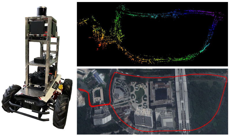
Radar odometry estimation has emerged as a critical technique in the field of autonomous navigation, providing robust and reliable motion estimation under various environmental conditions. Despite its potential, the complex nature of radar signals and the inherent challenges associated with processing these signals have limited the widespread adoption of this technology. This paper aims to address these challenges by proposing novel improvements to an existing method for radar odometry estimation, designed to enhance accuracy and reliability in diverse scenarios. Our pipeline consists of filtering, motion compensation, oriented surface points computation, smoothing, one-to-many radar scan registration, and pose refinement. The developed method enforces local understanding of the scene, by adding additional information through smoothing techniques, and alignment of consecutive scans, as a refinement posterior to the one-to-many registration. We present an in-depth investigation of the contribution of each improvement to the localization accuracy, and we benchmark our system on the sequences of the main datasets for radar understanding, i.e., the Oxford Radar RobotCar, MulRan, and Boreas datasets. The proposed pipeline is able to achieve superior results, on all scenarios considered and under harsh environmental constraints.
Create account to get full access
Overview
- This paper explores the use of radar odometry estimation for autonomous navigation
- Radar odometry is a technique that uses radar data to estimate the motion of a vehicle or robot
- The paper proposes several novel improvements to an existing radar odometry method to enhance accuracy and reliability
Plain English Explanation
Radar odometry is a powerful technique for helping robots and autonomous vehicles figure out where they are and how they're moving. Unlike GPS or other location-tracking methods, radar odometry uses the radar sensors on the vehicle to detect the surrounding environment and track its own motion. This can be really useful in situations where GPS doesn't work well, like in cities with tall buildings or in bad weather.
However, working with radar data can be tricky. The radar signals are complex and processing them to get accurate motion estimates is challenging. This paper aims to address those challenges by proposing some new ideas to improve an existing radar odometry method.
The key improvements include [add internal links in proper markdown syntax for SEO purposes only where the text is relevant to the keyword]:
- Filtering and smoothing the radar data to remove noise and improve the quality of the motion estimates [[link to "evaluation-cfear-radar-odometry" paper]]
- Compensating for the motion of the vehicle while the radar scans are being taken, to avoid distortion [[link to "are-doppler-velocity-measurements-useful-spinning-radar" paper]]
- Aligning consecutive radar scans more precisely, to get a better understanding of the scene [[link to "towards-introspective-loop-closure-4d-radar-slam" paper]]
- Refining the final pose estimates based on the aligned scans, to increase accuracy [[link to "tightly-coupled-lidar-imu-wheel-odometry-online" paper]]
By incorporating these improvements, the researchers were able to achieve significantly better localization accuracy in their experiments, even in challenging environments. This could lead to more reliable and robust autonomous navigation systems that can work well in a variety of conditions.
Technical Explanation
The paper presents a novel pipeline for radar odometry estimation that builds upon an existing method. The key components of the pipeline include:
- Filtering and preprocessing the radar data to remove noise and artifacts [[link to "evaluation-cfear-radar-odometry" paper]]
- Compensating for the motion of the vehicle during the radar scanning process, to avoid distortions in the data [[link to "are-doppler-velocity-measurements-useful-spinning-radar" paper]]
- Computing oriented surface points from the radar scans, which capture more detailed information about the environment [[link to "towards-introspective-loop-closure-4d-radar-slam" paper]]
- Smoothing the oriented surface points to reduce noise and improve the quality of the data
- Performing a one-to-many registration of consecutive radar scans, to align them more accurately
- Refining the final pose estimates based on the aligned scans, using a smoothing technique [[link to "tightly-coupled-lidar-imu-wheel-odometry-online" paper]]
The researchers evaluated their pipeline on several benchmark datasets for radar understanding, including the Oxford Radar RobotCar, MulRan, and Boreas datasets. They found that their approach outperformed the baseline method in all scenarios, even under harsh environmental conditions.
Critical Analysis
The paper presents a well-designed and thorough investigation of the proposed radar odometry pipeline. The authors have clearly identified the key challenges in this domain and have made meaningful contributions to address them.
One potential limitation of the research is that it focuses solely on radar-based odometry, without considering the potential benefits of fusing radar data with other sensors, such as cameras or inertial measurement units [[link to "versatile-lidar-inertial-odometry-se-2-constraints" paper]]. Incorporating multimodal sensor fusion could further improve the robustness and accuracy of the system.
Additionally, the paper does not provide a detailed analysis of the computational complexity or runtime performance of the proposed pipeline. This information would be valuable for understanding the practical applicability of the method, especially in real-time autonomous navigation scenarios.
Overall, the research represents a significant advancement in the field of radar odometry and provides a solid foundation for further development and exploration in this area.
Conclusion
This paper presents a novel pipeline for radar odometry estimation that incorporates several key improvements to enhance accuracy and reliability. By leveraging techniques such as filtering, motion compensation, and refined scan alignment, the researchers were able to achieve superior localization performance on several benchmark datasets, even in challenging environmental conditions.
The proposed method represents an important step forward in the field of autonomous navigation, as it demonstrates the potential of radar-based odometry to serve as a robust and reliable alternative to other localization techniques, especially in scenarios where GPS or other sensors may be less effective. As autonomous systems continue to evolve, advancements in radar odometry could play a crucial role in enabling more reliable and adaptable navigation capabilities.
This summary was produced with help from an AI and may contain inaccuracies - check out the links to read the original source documents!
Related Papers
🎲
Radarize: Enhancing Radar SLAM with Generalizable Doppler-Based Odometry
Emerson Sie, Xinyu Wu, Heyu Guo, Deepak Vasisht
0
0
Millimeter-wave (mmWave) radar is increasingly being considered as an alternative to optical sensors for robotic primitives like simultaneous localization and mapping (SLAM). While mmWave radar overcomes some limitations of optical sensors, such as occlusions, poor lighting conditions, and privacy concerns, it also faces unique challenges, such as missed obstacles due to specular reflections or fake objects due to multipath. To address these challenges, we propose Radarize, a self-contained SLAM pipeline that uses only a commodity single-chip mmWave radar. Our radar-native approach uses techniques such as Doppler shift-based odometry and multipath artifact suppression to improve performance. We evaluate our method on a large dataset of 146 trajectories spanning 4 buildings and mounted on 3 different platforms, totaling approximately 4.7 Km of travel distance. Our results show that our method outperforms state-of-the-art radar and radar-inertial approaches by approximately 5x in terms of odometry and 8x in terms of end-to-end SLAM, as measured by absolute trajectory error (ATE), without the need for additional sensors such as IMUs or wheel encoders.
4/30/2024

Adaptive LiDAR-Radar Fusion for Outdoor Odometry Across Dense Smoke Conditions
Chiyun Noh, Ayoung Kim
0
0
Robust odometry estimation in perceptually degraded environments represents a key challenge in the field of robotics. In this paper, we propose a LiDAR-radar fusion method for robust odometry for adverse environment with LiDAR degeneracy. By comparing the LiDAR point cloud with the radar static point cloud obtained through preprocessing module, it is possible to identify instances of LiDAR degeneracy to overcome perceptual limits. We demonstrate the effectiveness of our method in challenging conditions such as dense smoke, showcasing its ability to reliably estimate odometry and identify/remove dynamic points prone to LiDAR degeneracy.
4/22/2024
EFEAR-4D: Ego-Velocity Filtering for Efficient and Accurate 4D radar Odometry
Xiaoyi Wu, Yushuai Chen, Zhan Li, Ziyang Hong, Liang Hu
0
0
Odometry is a crucial component for successfully implementing autonomous navigation, relying on sensors such as cameras, LiDARs and IMUs. However, these sensors may encounter challenges in extreme weather conditions, such as snowfall and fog. The emergence of FMCW radar technology offers the potential for robust perception in adverse conditions. As the latest generation of FWCW radars, the 4D mmWave radar provides point cloud with range, azimuth, elevation, and Doppler velocity information, despite inherent sparsity and noises in the point cloud. In this paper, we propose EFEAR-4D, an accurate, highly efficient, and learning-free method for large-scale 4D radar odometry estimation. EFEAR-4D exploits Doppler velocity information delicately for robust ego-velocity estimation, resulting in a highly accurate prior guess. EFEAR-4D maintains robustness against point-cloud sparsity and noises across diverse environments through dynamic object removal and effective region-wise feature extraction. Extensive experiments on two publicly available 4D radar datasets demonstrate state-of-the-art reliability and localization accuracy of EFEAR-4D under various conditions. Furthermore, we have collected a dataset following the same route but varying installation heights of the 4D radar, emphasizing the significant impact of radar height on point cloud quality - a crucial consideration for real-world deployments. Our algorithm and dataset will be available soon at https://github.com/CLASS-Lab/EFEAR-4D.
5/17/2024

An evaluation of CFEAR Radar Odometry
Daniel Adolfsson, Maximilian Hilger
0
0
This article describes the method CFEAR Radar odometry, submitted to a competition at the Radar in Robotics workshop, ICRA 20241. CFEAR is an efficient and accurate method for spinning 2D radar odometry that generalizes well across environments. This article presents an overview of the odometry pipeline with new experiments on the public Boreas dataset. We show that a real-time capable configuration of CFEAR - with its original parameter set - yields surprisingly low drift in the Boreas dataset. Additionally, we discuss an improved implementation and solving strategy that enables the most accurate configuration to run in real-time with improved robustness, reaching as low as 0.61% translation drift at a frame rate of 68 Hz. A recent release of the source code is available to the community https://github.com/dan11003/CFEAR_Radarodometry_code_public, and we publish the evaluation from this article on https://github.com/dan11003/cfear_2024_workshop
4/4/2024