Insight Into the Collocation of Multi-Source Satellite Imagery for Multi-Scale Vessel Detection
2403.13698
0
0
🔎
Abstract
Ship detection from satellite imagery using Deep Learning (DL) is an indispensable solution for maritime surveillance. However, applying DL models trained on one dataset to others having differences in spatial resolution and radiometric features requires many adjustments. To overcome this issue, this paper focused on the DL models trained on datasets that consist of different optical images and a combination of radar and optical data. When dealing with a limited number of training images, the performance of DL models via this approach was satisfactory. They could improve 5-20% of average precision, depending on the optical images tested. Likewise, DL models trained on the combined optical and radar dataset could be applied to both optical and radar images. Our experiments showed that the models trained on an optical dataset could be used for radar images, while those trained on a radar dataset offered very poor scores when applied to optical images.
Create account to get full access
Overview
- Deep learning models can be used for effective maritime surveillance through ship detection in satellite imagery.
- However, applying these models trained on one dataset to other datasets with different spatial resolution and radiometric features requires substantial adjustments.
- This paper focuses on training deep learning models on datasets consisting of different optical images and a combination of radar and optical data to overcome this challenge.
- The approach demonstrates satisfactory performance even with a limited number of training images, improving average precision by 5-20% depending on the optical images.
- Deep learning models trained on the combined optical and radar dataset can be applied to both optical and radar images.
Plain English Explanation
This research paper explores how deep learning models can be used to detect ships in satellite imagery for maritime surveillance. One of the key challenges is that deep learning models trained on one dataset may not perform as well when applied to other datasets that have different visual characteristics, such as spatial resolution or brightness levels.
To address this issue, the researchers trained deep learning models on datasets that included a variety of optical satellite images as well as a combination of optical and radar data. They found that this approach yielded satisfactory performance even when the number of training images was limited, improving the average precision of the models by 5-20% depending on the specific optical images used.
Interestingly, the deep learning models trained on the combined optical and radar dataset were able to be applied to both optical and radar images effectively. However, the models trained solely on optical data did not perform as well when applied to radar images, while the radar-trained models struggled with optical images.
Technical Explanation
The researchers in this paper focused on developing deep learning models that could be applied to a wide range of satellite imagery datasets for effective ship detection, even when the visual characteristics of the datasets differed.
They trained their models on several different datasets, including those consisting solely of optical satellite images as well as a combined dataset with both optical and radar data. By using this diverse training data, the models were able to achieve satisfactory performance even when the number of training images was limited, improving average precision by 5-20% compared to models trained on a single dataset.
Notably, the models trained on the combined optical and radar dataset were able to be applied to both optical and radar imagery with good results. In contrast, the models trained only on optical data struggled when applied to radar images, while the radar-trained models performed poorly on optical images.
This suggests that combining different data modalities, such as optical and radar satellite imagery, during model training can help create more robust and versatile deep learning systems for maritime surveillance and other remote sensing applications.
Critical Analysis
The researchers in this paper present a promising approach for addressing the challenge of applying deep learning models trained on one satellite imagery dataset to others with different visual characteristics. By incorporating a range of optical and radar data during training, they were able to develop models with improved performance and flexibility.
However, the paper does not provide extensive details on the specific dataset characteristics, model architectures, or training hyperparameters used. This makes it difficult to fully evaluate the generalizability and robustness of the approach.
Additionally, the paper does not discuss potential limitations or caveats, such as the computational resources required to train the models on diverse datasets or the impact of different environmental conditions (e.g., weather, seasons) on model performance.
Further research could explore ways to generate synthetic satellite imagery to augment the training data, or investigate the use of transfer learning techniques to adapt pre-trained models to new datasets more efficiently.
Conclusion
This research paper presents a promising approach for training deep learning models for ship detection in satellite imagery that can be applied across a range of datasets with different visual characteristics. By incorporating both optical and radar data during model training, the researchers were able to develop more robust and versatile systems for maritime surveillance.
While the specific details of the approach could benefit from further exploration, the overall findings suggest that leveraging diverse data sources and modalities can help overcome the challenges of applying deep learning models to real-world remote sensing applications.
This summary was produced with help from an AI and may contain inaccuracies - check out the links to read the original source documents!
Related Papers

Comparing Deep Learning Models for Rice Mapping in Bhutan Using High Resolution Satellite Imagery
Biplov Bhandari, Timothy Mayer
0
0
The Bhutanese government is increasing its utilization of technological approaches such as including Remote Sensing-based knowledge in their decision-making process. This study focuses on crop type and crop extent in Paro, one of the top rice-yielding districts in Bhutan, and employs publicly available NICFI high-resolution satellite imagery from Planet. Two Deep Learning (DL) approaches, point-based (DNN) and patch-based (U-Net), models were used in conjunction with cloud-computing platforms. Three different models per DL approaches (DNN and U-Net) were trained: 1) RGBN channels from Planet; 2) RGBN and elevation data (RGBNE); 3) RGBN and Sentinel-1 (S1) data (RGBNS), and RGBN with E and S1 data (RGBNES). From this comprehensive analysis, the U-Net displayed higher performance metrics across both model training and model validation efforts. Among the U-Net model sets, the RGBN, RGBNE, RGBNS, and RGBNES models had an F1-score of 0.8546, 0.8563, 0.8467, and 0.8500 respectively. An independent model evaluation was performed and found a high level of performance variation across all the metrics. For this independent model evaluation, the U-Net RGBN, RGBNE, RGBNES, and RGBN models displayed the F1-scores of 0.5935, 0.6154, 0.5882, and 0.6582, suggesting U-Net RGBNES as the best model. The study shows that the DL approaches can predict rice. Also, DL methods can be used with the survey-based approaches currently utilized by the Bhutan Department of Agriculture. Further, this study demonstrated the usage of regional land cover products such as SERVIR's RLCMS as a weak label approach to capture different strata addressing the class imbalance problem and improving the sampling design for DL application. Finally, through preliminary model testing and comparisons outlined it was shown that using additional features such as NDVI, EVI, and NDWI did not drastically improve model performance.
6/12/2024
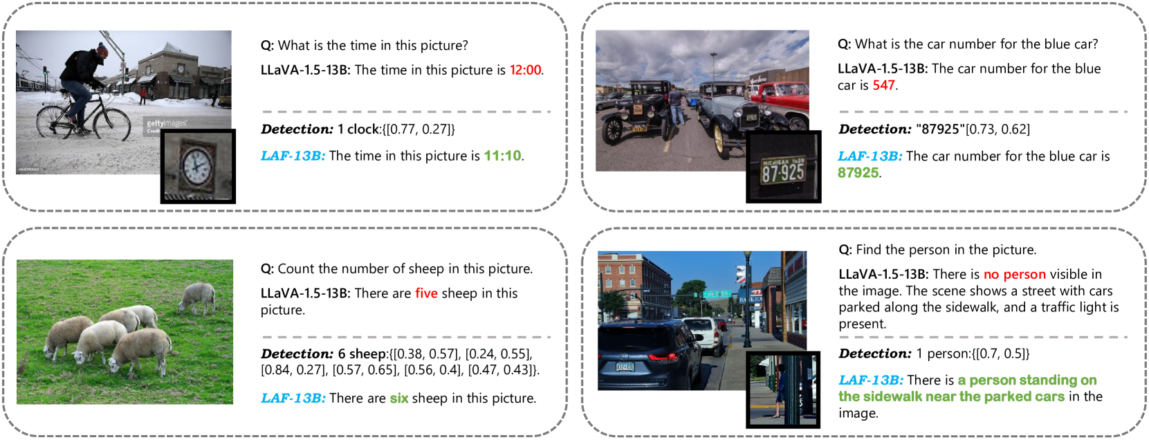
Enhancing Multimodal Large Language Models with Vision Detection Models: An Empirical Study
Qirui Jiao, Daoyuan Chen, Yilun Huang, Yaliang Li, Ying Shen
0
0
Despite the impressive capabilities of Multimodal Large Language Models (MLLMs) in integrating text and image modalities, challenges remain in accurately interpreting detailed visual elements. This paper presents an empirical study on enhancing MLLMs with state-of-the-art (SOTA) object detection and Optical Character Recognition (OCR) models to improve fine-grained understanding and reduce hallucination in responses. We investigate the embedding-based infusion of textual detection information, the impact of such infusion on MLLMs' original abilities, and the interchangeability of detection models. We conduct systematic and extensive experiments with representative models such as LLaVA-1.5, DINO, PaddleOCRv2, and Grounding DINO, revealing that our simple yet general approach not only refines MLLMs' performance in fine-grained visual tasks but also maintains their original strengths. Notably, the enhanced LLaVA-1.5 outperforms its original 7B/13B models on all 10 benchmarks, achieving an improvement of up to 12.5% on the normalized average score. We release our codes to facilitate further exploration into the fine-grained multimodal capabilities of MLLMs.
5/31/2024

Generating Synthetic Satellite Imagery With Deep-Learning Text-to-Image Models -- Technical Challenges and Implications for Monitoring and Verification
Tuong Vy Nguyen, Alexander Glaser, Felix Biessmann
0
0
Novel deep-learning (DL) architectures have reached a level where they can generate digital media, including photorealistic images, that are difficult to distinguish from real data. These technologies have already been used to generate training data for Machine Learning (ML) models, and large text-to-image models like DALL-E 2, Imagen, and Stable Diffusion are achieving remarkable results in realistic high-resolution image generation. Given these developments, issues of data authentication in monitoring and verification deserve a careful and systematic analysis: How realistic are synthetic images? How easily can they be generated? How useful are they for ML researchers, and what is their potential for Open Science? In this work, we use novel DL models to explore how synthetic satellite images can be created using conditioning mechanisms. We investigate the challenges of synthetic satellite image generation and evaluate the results based on authenticity and state-of-the-art metrics. Furthermore, we investigate how synthetic data can alleviate the lack of data in the context of ML methods for remote-sensing. Finally we discuss implications of synthetic satellite imagery in the context of monitoring and verification.
4/12/2024

A ground-based dataset and a diffusion model for on-orbit low-light image enhancement
Yiman Zhu, Lu Wang, Jingyi Yuan, Yu Guo
0
0
On-orbit service is important for maintaining the sustainability of space environment. Space-based visible camera is an economical and lightweight sensor for situation awareness during on-orbit service. However, it can be easily affected by the low illumination environment. Recently, deep learning has achieved remarkable success in image enhancement of natural images, but seldom applied in space due to the data bottleneck. In this article, we first propose a dataset of the Beidou Navigation Satellite for on-orbit low-light image enhancement (LLIE). In the automatic data collection scheme, we focus on reducing domain gap and improving the diversity of the dataset. we collect hardware in-the-loop images based on a robotic simulation testbed imitating space lighting conditions. To evenly sample poses of different orientation and distance without collision, a collision-free working space and pose stratified sampling is proposed. Afterwards, a novel diffusion model is proposed. To enhance the image contrast without over-exposure and blurring details, we design a fused attention to highlight the structure and dark region. Finally, we compare our method with previous methods using our dataset, which indicates that our method has a better capacity in on-orbit LLIE.
4/9/2024