A ground-based dataset and a diffusion model for on-orbit low-light image enhancement
2306.14227
0
0

Abstract
On-orbit service is important for maintaining the sustainability of space environment. Space-based visible camera is an economical and lightweight sensor for situation awareness during on-orbit service. However, it can be easily affected by the low illumination environment. Recently, deep learning has achieved remarkable success in image enhancement of natural images, but seldom applied in space due to the data bottleneck. In this article, we first propose a dataset of the Beidou Navigation Satellite for on-orbit low-light image enhancement (LLIE). In the automatic data collection scheme, we focus on reducing domain gap and improving the diversity of the dataset. we collect hardware in-the-loop images based on a robotic simulation testbed imitating space lighting conditions. To evenly sample poses of different orientation and distance without collision, a collision-free working space and pose stratified sampling is proposed. Afterwards, a novel diffusion model is proposed. To enhance the image contrast without over-exposure and blurring details, we design a fused attention to highlight the structure and dark region. Finally, we compare our method with previous methods using our dataset, which indicates that our method has a better capacity in on-orbit LLIE.
Create account to get full access
Overview
- This paper presents a diffusion model-based approach for enhancing low-light images from space satellite data.
- The proposed method aims to improve the quality and visibility of images captured in low-light conditions, which is a common challenge in space imaging applications.
- The researchers leverage the power of diffusion models, a type of generative AI, to effectively restore and enhance the details in these low-light satellite images.
Plain English Explanation
The researchers have developed a new way to improve the quality of satellite images taken in dim or dark lighting conditions. Often, when satellites take pictures from space, the images can appear dull, grainy, or lacking in detail due to the low amount of light available. This can make it difficult to clearly see important features or details in the images.
To address this, the researchers have used a type of AI called a "diffusion model." Diffusion models are a powerful form of generative AI that can create, transform, and enhance images in remarkable ways. In this case, the researchers have trained a diffusion model to take the low-quality, low-light satellite images and transform them into clearer, more detailed images with better visibility.
The key idea is that the diffusion model learns to "undo" the effects of low light, restoring the missing details and improving the overall quality of the satellite imagery. This can be particularly useful for applications where these satellite images are important, such as monitoring natural disasters, assessing aircraft activity, or enhancing low-light photography.
Technical Explanation
The researchers propose a diffusion model-based framework for low-light image enhancement in the context of space satellite imaging. Diffusion models are a type of generative AI that have shown impressive results in image-to-image translation tasks, making them well-suited for enhancing low-light satellite imagery.
The key components of the researchers' approach include:
-
Diffusion Model Architecture: The researchers leverage a state-of-the-art diffusion model architecture, similar to models used for other image enhancement tasks, to transform the low-light satellite images into high-quality, well-lit versions.
-
Training Data: To train the diffusion model, the researchers collected a dataset of low-light and corresponding high-quality satellite images. This allows the model to learn the mapping between the degraded low-light inputs and the desired enhanced outputs.
-
Optimization Objectives: The researchers define a set of loss functions and optimization objectives to guide the diffusion model during training. These include both perceptual and pixel-level losses to ensure the enhanced images are visually appealing and closely match the ground truth.
-
Inference and Enhancement: During inference, the trained diffusion model can be applied to new low-light satellite images to generate the enhanced, high-quality versions. This allows for effective low-light image enhancement without the need for complex post-processing steps.
The researchers evaluate their approach on several satellite imaging datasets and compare it to other state-of-the-art low-light enhancement techniques. The results demonstrate the effectiveness of the diffusion model-based method in restoring details and improving the overall quality of the low-light satellite imagery.
Critical Analysis
The researchers have presented a promising approach for addressing the challenge of low-light image enhancement in the context of space satellite imaging. The use of diffusion models, which have shown impressive performance in various image-to-image translation tasks, is a well-motivated choice for this problem.
One potential limitation of the research is the reliance on paired training data, where low-light and high-quality versions of the same satellite images are required. In real-world scenarios, it may be difficult to obtain such perfectly aligned datasets, especially for historical or archival satellite imagery. An interesting future direction could be to explore unsupervised or unpaired diffusion-based approaches that do not require this strict data pairing.
Additionally, the researchers could further investigate the robustness and generalization of their approach. Evaluating the method's performance on a wider range of satellite imaging conditions, such as varying weather, atmospheric conditions, or sensor types, would help establish the broader applicability of the proposed technique.
Overall, this research represents an important step forward in enhancing the quality and visibility of low-light satellite imagery, which has significant implications for a wide range of applications, including natural disaster monitoring, aircraft detection, and low-light photography. The diffusion model-based approach showcased in this paper demonstrates the potential of generative AI techniques to address complex image enhancement challenges in the space domain.
Conclusion
In this paper, the researchers have presented a novel diffusion model-based framework for enhancing low-light satellite images. By leveraging the powerful capabilities of diffusion models, they have demonstrated an effective way to restore details and improve the overall quality of satellite imagery captured under dim or dark lighting conditions.
The proposed approach has significant implications for a wide range of applications that rely on high-quality satellite data, such as natural disaster monitoring, aircraft tracking, and low-light photography. The ability to transform low-quality, low-light satellite images into clear, detailed versions can greatly enhance the usefulness and impact of these remote sensing technologies.
While the current research shows promising results, there are opportunities for further exploration and improvement, such as addressing the need for paired training data and evaluating the method's robustness across diverse satellite imaging scenarios. Nonetheless, this work represents an important step forward in the field of low-light image enhancement for space satellite applications, and it showcases the potential of generative AI techniques to tackle complex challenges in the space domain.
This summary was produced with help from an AI and may contain inaccuracies - check out the links to read the original source documents!
Related Papers

Data Augmentation in Earth Observation: A Diffusion Model Approach
Tiago Sousa, Beno^it Ries, Nicolas Guelfi
0
0
The scarcity of high-quality Earth Observation (EO) imagery poses a significant challenge, despite its critical role in enabling precise analysis and informed decision-making across various sectors. This scarcity is primarily due to atmospheric conditions, seasonal variations, and limited geographical coverage, which complicates the application of Artificial Intelligence (AI) in EO. Data augmentation, a widely used technique in AI that involves generating additional data mainly through parameterized image transformations, has been employed to increase the volume and diversity of data. However, this method often falls short in generating sufficient diversity across key semantic axes, adversely affecting the accuracy of EO applications. To address this issue, we propose a novel four-stage approach aimed at improving the diversity of augmented data by integrating diffusion models. Our approach employs meta-prompts for instruction generation, harnesses general-purpose vision-language models for generating rich captions, fine-tunes an Earth Observation diffusion model, and iteratively augments data. We conducted extensive experiments using four different data augmentation techniques, and our approach consistently demonstrated improvements, outperforming the established augmentation methods, revealing its effectiveness in generating semantically rich and diverse EO images.
6/11/2024
🔎
Insight Into the Collocation of Multi-Source Satellite Imagery for Multi-Scale Vessel Detection
Tran-Vu La, Minh-Tan Pham, Marco Chini
0
0
Ship detection from satellite imagery using Deep Learning (DL) is an indispensable solution for maritime surveillance. However, applying DL models trained on one dataset to others having differences in spatial resolution and radiometric features requires many adjustments. To overcome this issue, this paper focused on the DL models trained on datasets that consist of different optical images and a combination of radar and optical data. When dealing with a limited number of training images, the performance of DL models via this approach was satisfactory. They could improve 5-20% of average precision, depending on the optical images tested. Likewise, DL models trained on the combined optical and radar dataset could be applied to both optical and radar images. Our experiments showed that the models trained on an optical dataset could be used for radar images, while those trained on a radar dataset offered very poor scores when applied to optical images.
5/24/2024
📶
FLARE up your data: Diffusion-based Augmentation Method in Astronomical Imaging
Mohammed Talha Alam, Raza Imam, Mohsen Guizani, Fakhri Karray
0
0
The intersection of Astronomy and AI encounters significant challenges related to issues such as noisy backgrounds, lower resolution (LR), and the intricate process of filtering and archiving images from advanced telescopes like the James Webb. Given the dispersion of raw images in feature space, we have proposed a textit{two-stage augmentation framework} entitled as textbf{FLARE} based on underline{f}eature underline{l}earning and underline{a}ugmented underline{r}esolution underline{e}nhancement. We first apply lower (LR) to higher resolution (HR) conversion followed by standard augmentations. Secondly, we integrate a diffusion approach to synthetically generate samples using class-concatenated prompts. By merging these two stages using weighted percentiles, we realign the feature space distribution, enabling a classification model to establish a distinct decision boundary and achieve superior generalization on various in-domain and out-of-domain tasks. We conducted experiments on several downstream cosmos datasets and on our optimally distributed textbf{SpaceNet} dataset across 8-class fine-grained and 4-class macro classification tasks. FLARE attains the highest performance gain of 20.78% for fine-grained tasks compared to similar baselines, while across different classification models, FLARE shows a consistent increment of an average of +15%. This outcome underscores the effectiveness of the FLARE method in enhancing the precision of image classification, ultimately bolstering the reliability of astronomical research outcomes. % Our code and SpaceNet dataset will be released to the public soon. Our code and SpaceNet dataset is available at href{https://github.com/Razaimam45/PlanetX_Dxb}{textit{https://github.com/Razaimam45/PlanetX_Dxb}}.
5/24/2024
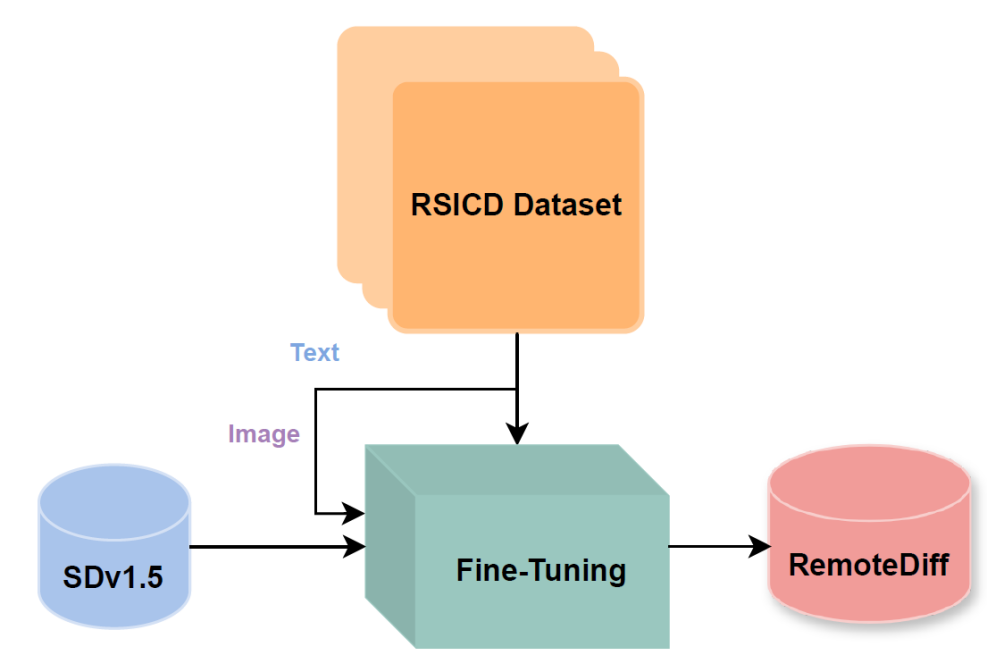
Remote Diffusion
Kunal Sunil Kasodekar
0
0
I explored adapting Stable Diffusion v1.5 for generating domain-specific satellite and aerial images in remote sensing. Recognizing the limitations of existing models like Midjourney and Stable Diffusion, trained primarily on natural RGB images and lacking context for remote sensing, I used the RSICD dataset to train a Stable Diffusion model with a loss of 0.2. I incorporated descriptive captions from the dataset for text-conditioning. Additionally, I created a synthetic dataset for a Land Use Land Classification (LULC) task, employing prompting techniques with RAG and ChatGPT and fine-tuning a specialized remote sensing LLM. However, I faced challenges with prompt quality and model performance. I trained a classification model (ResNet18) on the synthetic dataset achieving 49.48% test accuracy in TorchGeo to create a baseline. Quantitative evaluation through FID scores and qualitative feedback from domain experts assessed the realism and quality of the generated images and dataset. Despite extensive fine-tuning and dataset iterations, results indicated subpar image quality and realism, as indicated by high FID scores and domain-expert evaluation. These findings call attention to the potential of diffusion models in remote sensing while highlighting significant challenges related to insufficient pretraining data and computational resources.
5/9/2024