Landslide mapping from Sentinel-2 imagery through change detection
2405.20161
0
0

Abstract
Landslides are one of the most critical and destructive geohazards. Widespread development of human activities and settlements combined with the effects of climate change on weather are resulting in a high increase in the frequency and destructive power of landslides, making them a major threat to human life and the economy. In this paper, we explore methodologies to map newly-occurred landslides using Sentinel-2 imagery automatically. All approaches presented are framed as a bi-temporal change detection problem, requiring only a pair of Sentinel-2 images, taken respectively before and after a landslide-triggering event. Furthermore, we introduce a novel deep learning architecture for fusing Sentinel-2 bi-temporal image pairs with Digital Elevation Model (DEM) data, showcasing its promising performances w.r.t. other change detection models in the literature. As a parallel task, we address limitations in existing datasets by creating a novel geodatabase, which includes manually validated open-access landslide inventories over heterogeneous ecoregions of the world. We release both code and dataset with an open-source license.
Create account to get full access
Overview
- This paper presents a method for mapping landslides using Sentinel-2 satellite imagery and change detection techniques.
- The approach involves analyzing before and after images to identify areas where significant changes have occurred, which may indicate the presence of a landslide.
- The authors evaluate their method on several case studies and demonstrate its effectiveness in accurately detecting and mapping landslide events.
Plain English Explanation
Landslides are a major natural disaster that can cause significant damage to infrastructure and loss of life. Being able to quickly and accurately identify where landslides have occurred is crucial for disaster response and recovery efforts. This paper explores a new way to map landslides using satellite imagery from the Sentinel-2 satellite.
The key idea is to compare satellite images taken before and after a suspected landslide event. By looking for areas where the landscape has dramatically changed between the two time points, the researchers can infer the location of a landslide. This "change detection" approach allows them to automatically identify landslide-affected areas without having to manually inspect every inch of the satellite imagery.
The researchers tested their method on several case studies, including landslide events inItaly, India, and Nepal. They found that their approach was able to accurately pinpoint the location and extent of the landslides, providing a powerful tool for disaster monitoring and response.
Technical Explanation
The core of the researchers' approach is a change detection algorithm that compares Sentinel-2 satellite images captured before and after a suspected landslide event. The algorithm first preprocesses the images to correct for factors like atmospheric conditions and sensor differences between the two time points. It then calculates the normalized difference vegetation index (NDVI) for each pixel, which provides information about the health and density of vegetation.
By subtracting the NDVI values between the two images, the algorithm can identify areas where significant changes in vegetation have occurred. These "change hotspots" are then further analyzed to distinguish true landslide events from other types of landscape changes, such as forest clearing or construction. The final output is a map highlighting the location and boundaries of the detected landslides.
The researchers evaluated their method on several real-world case studies, includingvolcanic activity monitoring in Italy, a major landslide event in India, and a series of landslides triggered by the 2015 Nepal earthquake. In all cases, they found that their approach was able to accurately detect and delineate the landslide areas, outperforming manual mapping efforts in terms of speed and consistency.
Critical Analysis
One limitation of the researchers' approach is that it relies on the availability of high-quality, cloud-free satellite imagery before and after the landslide event. In many disaster scenarios, cloudy or obstructed imagery may hamper the change detection analysis. The authors acknowledge this challenge and suggest incorporating additional data sources, such as radar or aerial imagery, to improve the robustness of the method.
Additionally, the researchers note that their algorithm may struggle to differentiate between landslides and other types of landscape changes, such as construction or vegetation clearing. Further refinements to the change detection and classification algorithms could help improve the specificity of the landslide mapping.
Despite these caveats, the researchers' work demonstrates the significant potential of satellite-based change detection for rapid and comprehensive landslide mapping. As the availability and resolution of satellite imagery continues to improve, methods like the one presented in this paper could become invaluable tools for disaster response and urban planning efforts worldwide.
Conclusion
This paper presents a novel approach for mapping landslides using Sentinel-2 satellite imagery and change detection techniques. By comparing pre- and post-event satellite images, the researchers' algorithm can accurately identify the location and extent of landslide events, providing a powerful tool for disaster monitoring and response.
The researchers' case studies demonstrate the effectiveness of their method in various real-world settings, including landslide events in Italy, India, and Nepal. While the approach has some limitations, such as the need for high-quality, cloud-free imagery, the authors' work highlights the significant potential of satellite-based change detection for rapid and comprehensive landslide mapping.
As satellite technology continues to advance, methods like the one described in this paper could become increasingly valuable for a wide range of applications, from urban planning and infrastructure monitoring to disaster response and environmental conservation.
This summary was produced with help from an AI and may contain inaccuracies - check out the links to read the original source documents!
Related Papers
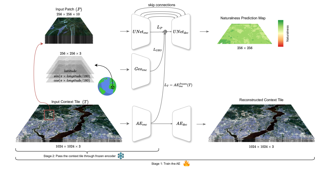
Mapping Land Naturalness from Sentinel-2 using Deep Contextual and Geographical Priors
Burak Ekim, Michael Schmitt
0
0
In recent decades, the causes and consequences of climate change have accelerated, affecting our planet on an unprecedented scale. This change is closely tied to the ways in which humans alter their surroundings. As our actions continue to impact natural areas, using satellite images to observe and measure these effects has become crucial for understanding and combating climate change. Aiming to map land naturalness on the continuum of modern human pressure, we have developed a multi-modal supervised deep learning framework that addresses the unique challenges of satellite data and the task at hand. We incorporate contextual and geographical priors, represented by corresponding coordinate information and broader contextual information, including and surrounding the immediate patch to be predicted. Our framework improves the model's predictive performance in mapping land naturalness from Sentinel-2 data, a type of multi-spectral optical satellite imagery. Recognizing that our protective measures are only as effective as our understanding of the ecosystem, quantifying naturalness serves as a crucial step toward enhancing our environmental stewardship.
6/28/2024

Global Mapping of Exposure and Physical Vulnerability Dynamics in Least Developed Countries using Remote Sensing and Machine Learning
Joshua Dimasaka, Christian Gei{ss}, Emily So
0
0
As the world marked the midterm of the Sendai Framework for Disaster Risk Reduction 2015-2030, many countries are still struggling to monitor their climate and disaster risk because of the expensive large-scale survey of the distribution of exposure and physical vulnerability and, hence, are not on track in reducing risks amidst the intensifying effects of climate change. We present an ongoing effort in mapping this vital information using machine learning and time-series remote sensing from publicly available Sentinel-1 SAR GRD and Sentinel-2 Harmonized MSI. We introduce the development of OpenSendaiBench consisting of 47 countries wherein most are least developed (LDCs), trained ResNet-50 deep learning models, and demonstrated the region of Dhaka, Bangladesh by mapping the distribution of its informal constructions. As a pioneering effort in auditing global disaster risk over time, this paper aims to advance the area of large-scale risk quantification in informing our collective long-term efforts in reducing climate and disaster risk.
4/3/2024

High-Resolution Building and Road Detection from Sentinel-2
Wojciech Sirko, Emmanuel Asiedu Brempong, Juliana T. C. Marcos, Abigail Annkah, Abel Korme, Mohammed Alewi Hassen, Krishna Sapkota, Tomer Shekel, Abdoulaye Diack, Sella Nevo, Jason Hickey, John Quinn
0
0
Mapping buildings and roads automatically with remote sensing typically requires high-resolution imagery, which is expensive to obtain and often sparsely available. In this work we demonstrate how multiple 10 m resolution Sentinel-2 images can be used to generate 50 cm resolution building and road segmentation masks. This is done by training a `student' model with access to Sentinel-2 images to reproduce the predictions of a `teacher' model which has access to corresponding high-resolution imagery. While the predictions do not have all the fine detail of the teacher model, we find that we are able to retain much of the performance: for building segmentation we achieve 78.3% mIoU, compared to the high-resolution teacher model accuracy of 85.3% mIoU. We also describe a related method for counting individual buildings in a Sentinel-2 patch which achieves R^2 = 0.91 against true counts. This work opens up new possibilities for using freely available Sentinel-2 imagery for a range of tasks that previously could only be done with high-resolution satellite imagery.
6/21/2024

Advanced Feature Manipulation for Enhanced Change Detection Leveraging Natural Language Models
Zhenglin Li, Yangchen Huang, Mengran Zhu, Jingyu Zhang, JingHao Chang, Houze Liu
0
0
Change detection is a fundamental task in computer vision that processes a bi-temporal image pair to differentiate between semantically altered and unaltered regions. Large language models (LLMs) have been utilized in various domains for their exceptional feature extraction capabilities and have shown promise in numerous downstream applications. In this study, we harness the power of a pre-trained LLM, extracting feature maps from extensive datasets, and employ an auxiliary network to detect changes. Unlike existing LLM-based change detection methods that solely focus on deriving high-quality feature maps, our approach emphasizes the manipulation of these feature maps to enhance semantic relevance.
6/14/2024