Global Mapping of Exposure and Physical Vulnerability Dynamics in Least Developed Countries using Remote Sensing and Machine Learning
2404.01748
0
0

Abstract
As the world marked the midterm of the Sendai Framework for Disaster Risk Reduction 2015-2030, many countries are still struggling to monitor their climate and disaster risk because of the expensive large-scale survey of the distribution of exposure and physical vulnerability and, hence, are not on track in reducing risks amidst the intensifying effects of climate change. We present an ongoing effort in mapping this vital information using machine learning and time-series remote sensing from publicly available Sentinel-1 SAR GRD and Sentinel-2 Harmonized MSI. We introduce the development of OpenSendaiBench consisting of 47 countries wherein most are least developed (LDCs), trained ResNet-50 deep learning models, and demonstrated the region of Dhaka, Bangladesh by mapping the distribution of its informal constructions. As a pioneering effort in auditing global disaster risk over time, this paper aims to advance the area of large-scale risk quantification in informing our collective long-term efforts in reducing climate and disaster risk.
Create account to get full access
Overview
- This paper proposes a framework for globally mapping exposure and physical vulnerability dynamics in less developed countries using remote sensing data and machine learning techniques.
- The researchers developed the "OpenSendaiBench" dataset, which combines various data sources to provide comprehensive information on disaster risk factors.
- The framework leverages machine learning models to analyze the remote sensing data and generate insights about exposure and vulnerability across different regions.
- The goal is to provide policymakers and disaster management organizations with a tool to better understand and address disaster risks in the world's most vulnerable areas.
Plain English Explanation
The paper tackles an important challenge - how to better understand and prepare for natural disasters in the world's poorest regions. The researchers recognized that many less developed countries lack comprehensive data on the factors that contribute to disaster risk, such as the location and condition of buildings, infrastructure, and populations.
To address this, the researchers created a new dataset called "OpenSendaiBench" that combines satellite imagery, maps, and other data sources to paint a more complete picture of disaster exposure and vulnerability. They then used advanced machine learning techniques to analyze this data and generate detailed insights about where disasters are most likely to occur and which communities are most at risk.
The goal is to provide policymakers and disaster response organizations with a powerful tool to identify high-risk areas, allocate resources more effectively, and implement measures to strengthen resilience before disasters strike. By using advanced technology to fill critical data gaps, the researchers hope to empower vulnerable communities to be better prepared and protected.
Technical Explanation
The paper presents a framework for global mapping of exposure and physical vulnerability dynamics using remote sensing data and machine learning. The core components are:
-
The "OpenSendaiBench" dataset: This dataset combines satellite imagery, building footprints, population data, and other geospatial information to provide comprehensive data on disaster risk factors across less developed countries.
-
Machine learning models: The researchers trained various models, including convolutional neural networks and random forest classifiers, to analyze the remote sensing data and extract insights about exposure (e.g. building locations, infrastructure) and vulnerability (e.g. structural conditions, population density).
-
Predictive mapping: By applying the trained models to the full dataset, the researchers were able to generate high-resolution maps depicting the spatial distribution of exposure and vulnerability across different regions.
The key innovations include the development of the standardized, open-source "OpenSendaiBench" dataset, as well as the application of state-of-the-art machine learning techniques to remote sensing data for global-scale disaster risk assessment. The results provide detailed, localized information to support disaster risk reduction efforts in some of the world's most vulnerable areas.
Critical Analysis
The paper presents a compelling framework that leverages cutting-edge data and analytical techniques to tackle an important global challenge. However, the researchers acknowledge several limitations and areas for further development:
- The dataset, while extensive, may still have gaps or biases in geographic coverage and data quality, especially in the most remote and under-resourced regions.
- The machine learning models, while high-performing, rely on certain assumptions and could be susceptible to errors or overconfidence in their predictions.
- The framework focuses primarily on physical vulnerability, while other social, economic, and institutional factors also play a critical role in disaster resilience.
- Translating the insights into actionable policies and interventions at the local level will require close collaboration with governments and communities.
Addressing these challenges will be important to fully realize the potential of this approach. Nevertheless, the research represents an important step forward in leveraging data and technology to better understand and mitigate disaster risks in the world's most vulnerable regions.
Conclusion
This paper presents a innovative framework for global mapping of disaster exposure and physical vulnerability using remote sensing data and machine learning. By developing the comprehensive "OpenSendaiBench" dataset and applying advanced analytics, the researchers have created a powerful tool to support disaster risk reduction efforts in less developed countries.
The results provide detailed, localized insights that can empower policymakers, disaster responders, and vulnerable communities to better prepare for and withstand natural hazards. While there are some limitations that require further research, this work demonstrates the transformative potential of data-driven approaches to tackle complex global challenges. Continued progress in this direction could lead to meaningful improvements in building resilience and protecting lives in the face of growing disaster risks.
This summary was produced with help from an AI and may contain inaccuracies - check out the links to read the original source documents!
Related Papers

Deep Learning for Slum Mapping in Remote Sensing Images: A Meta-analysis and Review
Anjali Raj, Adway Mitra, Manjira Sinha
0
0
The major Sustainable Development Goals (SDG) 2030, set by the United Nations Development Program (UNDP), include sustainable cities and communities, no poverty, and reduced inequalities. However, millions of people live in slums or informal settlements with poor living conditions in many major cities around the world, especially in less developed countries. To emancipate these settlements and their inhabitants through government intervention, accurate data about slum location and extent is required. While ground survey data is the most reliable, such surveys are costly and time-consuming. An alternative is remotely sensed data obtained from very high-resolution (VHR) imagery. With the advancement of new technology, remote sensing based mapping of slums has emerged as a prominent research area. The parallel rise of Artificial Intelligence, especially Deep Learning has added a new dimension to this field as it allows automated analysis of satellite imagery to identify complex spatial patterns associated with slums. This article offers a detailed review and meta-analysis of research on slum mapping using remote sensing imagery from 2014 to 2024, with a special focus on deep learning approaches. Our analysis reveals a trend towards increasingly complex neural network architectures, with advancements in data preprocessing and model training techniques significantly enhancing slum identification accuracy. We have attempted to identify key methodologies that are effective across diverse geographic contexts. While acknowledging the transformative impact Convolutional Neural Networks (CNNs) in slum detection, our review underscores the absence of a universally optimal model, suggesting the need for context-specific adaptations. We also identify prevailing challenges in this field, such as data limitations and a lack of model explainability and suggest potential strategies for overcoming these.
6/13/2024
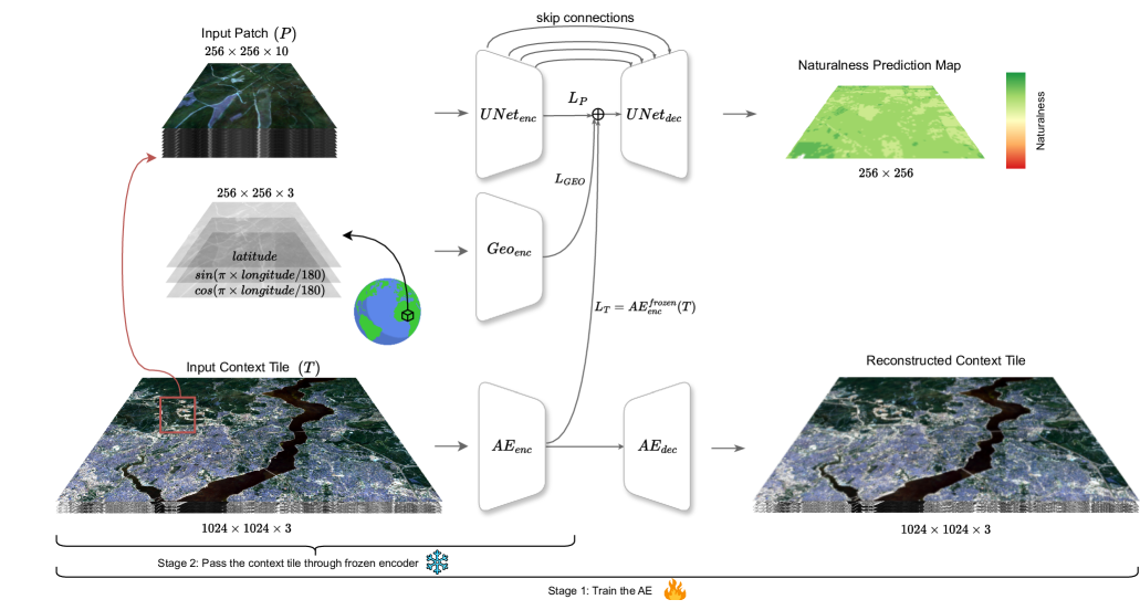
Mapping Land Naturalness from Sentinel-2 using Deep Contextual and Geographical Priors
Burak Ekim, Michael Schmitt
0
0
In recent decades, the causes and consequences of climate change have accelerated, affecting our planet on an unprecedented scale. This change is closely tied to the ways in which humans alter their surroundings. As our actions continue to impact natural areas, using satellite images to observe and measure these effects has become crucial for understanding and combating climate change. Aiming to map land naturalness on the continuum of modern human pressure, we have developed a multi-modal supervised deep learning framework that addresses the unique challenges of satellite data and the task at hand. We incorporate contextual and geographical priors, represented by corresponding coordinate information and broader contextual information, including and surrounding the immediate patch to be predicted. Our framework improves the model's predictive performance in mapping land naturalness from Sentinel-2 data, a type of multi-spectral optical satellite imagery. Recognizing that our protective measures are only as effective as our understanding of the ecosystem, quantifying naturalness serves as a crucial step toward enhancing our environmental stewardship.
6/28/2024

An Open-Source Tool for Mapping War Destruction at Scale in Ukraine using Sentinel-1 Time Series
Olivier Dietrich, Torben Peters, Vivien Sainte Fare Garnot, Valerie Sticher, Thao Ton-That Whelan, Konrad Schindler, Jan Dirk Wegner
0
0
Access to detailed war impact assessments is crucial for humanitarian organizations to effectively assist populations most affected by armed conflicts. However, maintaining a comprehensive understanding of the situation on the ground is challenging, especially in conflicts that cover vast territories and extend over long periods. This study presents a scalable and transferable method for estimating war-induced damage to buildings. We first train a machine learning model to output pixel-wise probability of destruction from Synthetic Aperture Radar (SAR) satellite image time series, leveraging existing, manual damage assessments as ground truth and cloud-based geospatial analysis tools for large-scale inference. We further post-process these assessments using open building footprints to obtain a final damage estimate per building. We introduce an accessible, open-source tool that allows users to adjust the confidence interval based on their specific requirements and use cases. Our approach enables humanitarian organizations and other actors to rapidly screen large geographic regions for war impacts. We provide two publicly accessible dashboards: a Ukraine Damage Explorer to dynamically view our pre-computed estimates, and a Rapid Damage Mapping Tool to easily run our method and produce custom maps.
6/5/2024
DeepDamageNet: A two-step deep-learning model for multi-disaster building damage segmentation and classification using satellite imagery
Irene Alisjahbana (Mullet), Jiawei Li (Mullet), Ben (Mullet), Strong, Yue Zhang
0
0
Satellite imagery has played an increasingly important role in post-disaster building damage assessment. Unfortunately, current methods still rely on manual visual interpretation, which is often time-consuming and can cause very low accuracy. To address the limitations of manual interpretation, there has been a significant increase in efforts to automate the process. We present a solution that performs the two most important tasks in building damage assessment, segmentation and classification, through deep-learning models. We show our results submitted as part of the xView2 Challenge, a competition to design better models for identifying buildings and their damage level after exposure to multiple kinds of natural disasters. Our best model couples a building identification semantic segmentation convolutional neural network (CNN) to a building damage classification CNN, with a combined F1 score of 0.66, surpassing the xView2 challenge baseline F1 score of 0.28. We find that though our model was able to identify buildings with relatively high accuracy, building damage classification across various disaster types is a difficult task due to the visual similarity between different damage levels and different damage distribution between disaster types, highlighting the fact that it may be important to have a probabilistic prior estimate regarding disaster damage in order to obtain accurate predictions.
5/9/2024