Multi-Robot Collaborative Localization and Planning with Inter-Ranging
2406.16679
0
0
Abstract
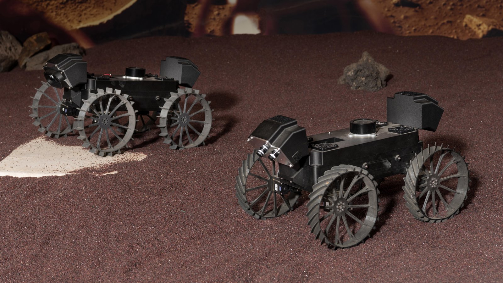
Robots often use feature-based image tracking to identify their position in their surrounding environment; however, feature-based image tracking is prone to errors in low-textured and poorly lit environments. Specifically, we investigate a scenario where robots are tasked with exploring the surface of the Moon and are required to have an accurate estimate of their position to be able to correctly geotag scientific measurements. To reduce localization error, we complement traditional feature-based image tracking with ultra-wideband (UWB) distance measurements between the robots. The robots use an advanced mesh-ranging protocol that allows them to continuously share distance measurements amongst each other rather than relying on the common anchor and tag UWB architecture. We develop a decentralized multi-robot coordination algorithm that actively plans paths based on measurement line-of-sight vectors amongst all robots to minimize collective localization error. We then demonstrate the emergent behavior of the proposed multi-robot coordination algorithm both in simulation and hardware to lower a geometry-based uncertainty metric and reduce localization error.
Create account to get full access
Overview
- This paper presents a multi-robot system that combines collaborative localization and planning with inter-ranging capabilities.
- The system allows robots to share sensor data and coordinate their movements to efficiently explore and map an environment.
- Key features include distributed localization, collision avoidance, and task assignment algorithms that leverage inter-robot ranging measurements.
Plain English Explanation
In this research, a team developed a system that allows multiple robots to work together effectively. The robots can share information about their surroundings and coordinate their movements to explore an area more efficiently.
The core idea is that the robots can measure the distances between each other using specialized sensors. This inter-ranging information allows the robots to better localize themselves and plan their movements collaboratively.
For example, if one robot detects an obstacle, it can share that information with the other robots. They can then adjust their paths to avoid collisions and cover more ground together. The system also includes algorithms to efficiently assign tasks to the different robots.
By working as a team and sharing data, the robots can create a more complete map of their environment and accomplish their objectives faster than they could alone. This kind of multi-robot coordination has many potential applications, such as search and rescue, exploration, and surveillance missions.
Technical Explanation
The paper presents a distributed multi-robot system that leverages inter-ranging measurements to enable collaborative localization and planning. Each robot is equipped with sensors that can detect the distances to nearby robots, which allows them to localize themselves more accurately within the shared environment.
The system's architecture includes several key components:
-
Distributed Localization: The robots share their local sensor data and use sensor fusion techniques to collaboratively estimate their positions and orientations.
-
Collision Avoidance: The robots exchange their planned trajectories and use adaptive algorithms to adjust their paths to avoid collisions with each other and static obstacles.
-
Task Assignment: The system includes a distributed task assignment module that dynamically allocates exploration and mapping objectives to the robots based on their current locations and capabilities.
The authors evaluate the performance of their system through extensive simulations and real-world experiments, demonstrating its ability to efficiently explore and map unknown environments while maintaining robust coordination and localization.
Critical Analysis
The paper presents a compelling multi-robot system that leverages inter-ranging capabilities to enable collaborative localization and planning. The authors have done a thorough job of designing and evaluating their approach, and the results seem promising.
One potential limitation is the reliance on accurate inter-ranging measurements, which may be challenging to obtain in certain environments or with unreliable sensors. The authors acknowledge this and suggest further research into more robust sensor fusion and localization techniques.
Additionally, the paper does not address potential issues with scalability as the number of robots increases. It would be interesting to see how the system's performance and coordination mechanisms scale in larger multi-robot teams.
Overall, this research represents an important contribution to the field of multi-robot systems and demonstrates the potential benefits of leveraging inter-robot ranging and collaboration. Further development and real-world deployment of such systems could lead to significant advancements in areas like search and rescue, exploration, and surveillance.
Conclusion
This paper presents a novel multi-robot system that combines collaborative localization and planning with inter-ranging capabilities. By allowing robots to share sensor data and coordinate their movements, the system enables efficient exploration and mapping of unknown environments.
The key innovations include distributed localization algorithms, collision avoidance mechanisms, and dynamic task assignment strategies that leverage inter-robot ranging measurements. The authors demonstrate the effectiveness of their approach through simulations and real-world experiments.
While the system shows promise, further research is needed to address potential limitations, such as sensor reliability and scalability. Nevertheless, this work represents an important step forward in the development of collaborative multi-robot systems with practical applications in areas like search and rescue, exploration, and surveillance.
This summary was produced with help from an AI and may contain inaccuracies - check out the links to read the original source documents!
Related Papers
🎯
Cooperative Relative Localization in MAV Swarms with Ultra-wideband Ranging
Changrui Liu, Sven U. Pfeiffer, Guido C. H. E. de Croon
0
0
Relative localization (RL) is essential for the successful operation of micro air vehicle (MAV) swarms. Achieving accurate 3-D RL in infrastructure-free and GPS-denied environments with only distance information is a challenging problem that has not been satisfactorily solved. In this work, based on the range-based peer-to-peer RL using the ultra-wideband (UWB) ranging technique, we develop a novel UWB-based cooperative relative localization (CRL) solution that integrates the relative motion dynamics of each host-neighbor pair to build a unified dynamic model and takes the distances between the neighbors as textit{bonus information}. Observability analysis using differential geometry shows that the proposed CRL scheme can expand the observable subspace compared to other alternatives using only direct distances between the host agent and its neighbors. In addition, we apply the kernel-induced extended Kalman filter (EKF) to the CRL state estimation problem with the novel-designed Logarithmic-Versoria (LV) kernel to tackle heavy-tailed UWB noise. Sufficient conditions for the convergence of the fixed-point iteration involved in the estimation algorithm are also derived. Comparative Monte Carlo simulations demonstrate that the proposed CRL scheme combined with the LV-kernel EKF significantly improves the estimation accuracy owing to its robustness against both measurement outliers and incorrect measurement covariance matrix initialization. Moreover, with the LV kernel, the estimation is still satisfactory when performing the fixed-point iteration only once for reduced computational complexity.
5/29/2024
📊
Fast Estimation of Relative Transformation Based on Fusion of Odometry and UWB Ranging Data
Yuan Fu, Zheng Zhang, Guangyang Zeng, Chun Liu, Junfeng Wu, Xiaoqiang Ren
0
0
In this paper, we investigate the problem of estimating the 4-DOF (three-dimensional position and orientation) robot-robot relative frame transformation using odometers and distance measurements between robots. Firstly, we apply a two-step estimation method based on maximum likelihood estimation. Specifically, a good initial value is obtained through unconstrained least squares and projection, followed by a more accurate estimate achieved through one-step Gauss-Newton iteration. Additionally, the optimal installation positions of Ultra-Wideband (UWB) are provided, and the minimum operating time under different quantities of UWB devices is determined. Simulation demonstrates that the two-step approach offers faster computation with guaranteed accuracy while effectively addressing the relative transformation estimation problem within limited space constraints. Furthermore, this method can be applied to real-time relative transformation estimation when a specific number of UWB devices are installed.
5/22/2024

Multi-Robot Target Tracking with Sensing and Communication Danger Zones
Jiazhen Liu, Peihan Li, Yuwei Wu, Gaurav S. Sukhatme, Vijay Kumar, Lifeng Zhou
0
0
Multi-robot target tracking finds extensive applications in different scenarios, such as environmental surveillance and wildfire management, which require the robustness of the practical deployment of multi-robot systems in uncertain and dangerous environments. Traditional approaches often focus on the performance of tracking accuracy with no modeling and assumption of the environments, neglecting potential environmental hazards which result in system failures in real-world deployments. To address this challenge, we investigate multi-robot target tracking in the adversarial environment considering sensing and communication attacks with uncertainty. We design specific strategies to avoid different danger zones and proposed a multi-agent tracking framework under the perilous environment. We approximate the probabilistic constraints and formulate practical optimization strategies to address computational challenges efficiently. We evaluate the performance of our proposed methods in simulations to demonstrate the ability of robots to adjust their risk-aware behaviors under different levels of environmental uncertainty and risk confidence. The proposed method is further validated via real-world robot experiments where a team of drones successfully track dynamic ground robots while being risk-aware of the sensing and/or communication danger zones.
6/24/2024

Semi-Supervised Novelty Detection for Precise Ultra-Wideband Error Signal Prediction
Umberto Albertin, Alessandro Navone, Mauro Martini, Marcello Chiaberge
0
0
Ultra-Wideband (UWB) technology is an emerging low-cost solution for localization in a generic environment. However, UWB signal can be affected by signal reflections and non-line-of-sight (NLoS) conditions between anchors; hence, in a broader sense, the specific geometry of the environment and the disposition of obstructing elements in the map may drastically hinder the reliability of UWB for precise robot localization. This work aims to mitigate this problem by learning a map-specific characterization of the UWB quality signal with a fingerprint semi-supervised novelty detection methodology. An unsupervised autoencoder neural network is trained on nominal UWB map conditions, and then it is used to predict errors derived from the introduction of perturbing novelties in the environment. This work poses a step change in the understanding of UWB localization and its reliability in evolving environmental conditions. The resulting performance of the proposed method is proved by fine-grained experiments obtained with a visual tracking ground truth.
4/9/2024