Multiplane Prior Guided Few-Shot Aerial Scene Rendering
2406.04961
0
0
Abstract
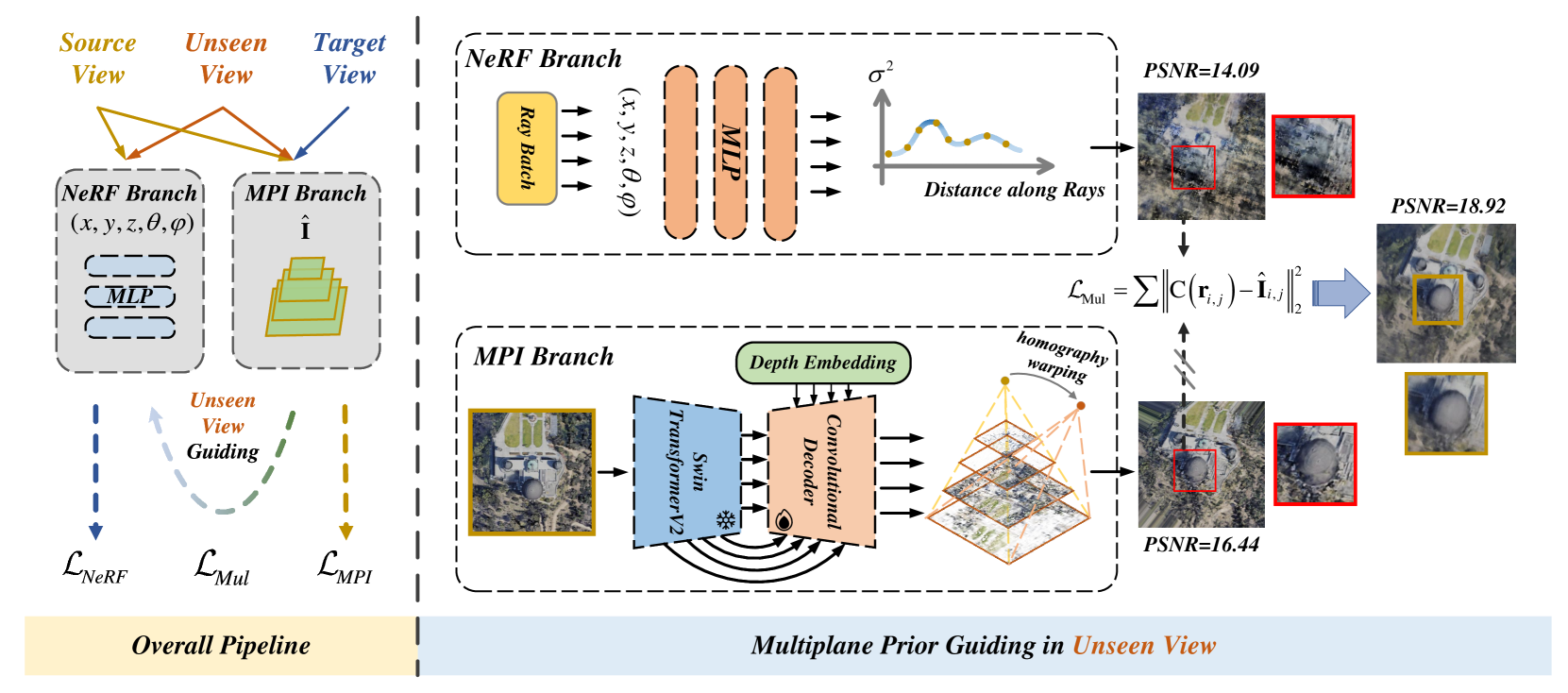
Neural Radiance Fields (NeRF) have been successfully applied in various aerial scenes, yet they face challenges with sparse views due to limited supervision. The acquisition of dense aerial views is often prohibitive, as unmanned aerial vehicles (UAVs) may encounter constraints in perspective range and energy constraints. In this work, we introduce Multiplane Prior guided NeRF (MPNeRF), a novel approach tailored for few-shot aerial scene rendering-marking a pioneering effort in this domain. Our key insight is that the intrinsic geometric regularities specific to aerial imagery could be leveraged to enhance NeRF in sparse aerial scenes. By investigating NeRF's and Multiplane Image (MPI)'s behavior, we propose to guide the training process of NeRF with a Multiplane Prior. The proposed Multiplane Prior draws upon MPI's benefits and incorporates advanced image comprehension through a SwinV2 Transformer, pre-trained via SimMIM. Our extensive experiments demonstrate that MPNeRF outperforms existing state-of-the-art methods applied in non-aerial contexts, by tripling the performance in SSIM and LPIPS even with three views available. We hope our work offers insights into the development of NeRF-based applications in aerial scenes with limited data.
Create account to get full access
Overview
- This paper proposes a method called "Multiplane Prior Guided Few-Shot Aerial Scene Rendering" for efficiently rendering complex aerial scenes from a small number of input images.
- The key idea is to leverage a pre-trained multiplane prior to guide the rendering process, allowing for high-quality results even with limited data.
- The approach combines a multiplane representation with a neural radiance field (NeRF) model, enabling accurate reconstruction of 3D aerial scenes.
Plain English Explanation
The paper introduces a new technique for creating detailed 3D models of aerial scenes, such as cities or landscapes, using only a few input photos. The core innovation is the use of a "multiplane prior" - a pre-trained model that understands the typical structure of aerial environments. This prior knowledge helps guide the rendering process, allowing the system to produce high-quality 3D reconstructions even when only a small number of input images are available.
The method works by combining the multiplane prior with a neural radiance field (NeRF) model. NeRF is a powerful technique for representing 3D scenes as a continuous volumetric function. By incorporating the multiplane prior, the system can more accurately capture the complex geometry and appearance of aerial landscapes from limited data.
This is an important advance because capturing detailed 3D models of large-scale outdoor environments is challenging, often requiring extensive data collection and processing. The approach described in this paper provides a more efficient solution, potentially enabling new applications in areas like urban planning, disaster response, and aerial photography.
Technical Explanation
The key technical contributions of this paper are:
-
Multiplane Prior: The authors leverage a pre-trained model that encodes the typical structure of aerial scenes, such as the arrangement of buildings, roads, and vegetation. This "multiplane prior" provides a strong inductive bias to guide the 3D reconstruction process.
-
Hybrid Representation: The system combines the multiplane prior with a neural radiance field (NeRF) model, which represents the scene as a continuous volumetric function. This hybrid approach allows for accurate reconstruction of complex 3D geometries and appearances.
-
Few-Shot Adaptation: The model is designed to adapt to new scenes using only a small number of input images, enabling efficient 3D reconstruction without the need for extensive data collection.
The authors evaluate their approach on a range of aerial scene datasets, demonstrating significant improvements in rendering quality and efficiency compared to baseline NeRF models. The multiplane prior is shown to be particularly effective at capturing the structural regularities of aerial environments, leading to more accurate 3D reconstructions from limited data.
Critical Analysis
One potential limitation of this approach is the reliance on the pre-trained multiplane prior. While this prior knowledge can greatly improve performance, it may also introduce biases or restrict the system's ability to capture unique or unconventional aerial scenes. The authors acknowledge this issue and suggest that further research is needed to explore more flexible priors or ways to dynamically adapt the prior during inference.
Additionally, the paper does not provide a thorough analysis of the computational and memory requirements of the proposed method, which could be an important practical consideration for real-world deployment. Comparing the efficiency of this approach to other recent advances in aerial NeRF, multi-view NeRF, and depth-supervised reconstruction could yield valuable insights.
Finally, while the paper demonstrates impressive results on benchmark datasets, it would be interesting to see the method applied to real-world aerial photography or remote sensing scenarios, where additional challenges like camera calibration, occlusions, and dynamic elements may arise.
Conclusion
This paper presents an innovative approach to efficient 3D reconstruction of aerial scenes using a multiplane prior to guide a neural radiance field model. By leveraging pre-trained knowledge about the typical structure of aerial environments, the system can produce high-quality 3D renderings from a small number of input images, potentially enabling new applications in areas like urban planning, disaster response, and aerial photography. While the approach shows promising results, further research is needed to explore the limitations and practical considerations of this technique.
This summary was produced with help from an AI and may contain inaccuracies - check out the links to read the original source documents!
Related Papers
🏅
Aerial-NeRF: Adaptive Spatial Partitioning and Sampling for Large-Scale Aerial Rendering
Xiaohan Zhang, Yukui Qiu, Zhenyu Sun, Qi Liu
0
0
Recent progress in large-scale scene rendering has yielded Neural Radiance Fields (NeRF)-based models with an impressive ability to synthesize scenes across small objects and indoor scenes. Nevertheless, extending this idea to large-scale aerial rendering poses two critical problems. Firstly, a single NeRF cannot render the entire scene with high-precision for complex large-scale aerial datasets since the sampling range along each view ray is insufficient to cover buildings adequately. Secondly, traditional NeRFs are infeasible to train on one GPU to enable interactive fly-throughs for modeling massive images. Instead, existing methods typically separate the whole scene into multiple regions and train a NeRF on each region, which are unaccustomed to different flight trajectories and difficult to achieve fast rendering. To that end, we propose Aerial-NeRF with three innovative modifications for jointly adapting NeRF in large-scale aerial rendering: (1) Designing an adaptive spatial partitioning and selection method based on drones' poses to adapt different flight trajectories; (2) Using similarity of poses instead of (expert) network for rendering speedup to determine which region a new viewpoint belongs to; (3) Developing an adaptive sampling approach for rendering performance improvement to cover the entire buildings at different heights. Extensive experiments have conducted to verify the effectiveness and efficiency of Aerial-NeRF, and new state-of-the-art results have been achieved on two public large-scale aerial datasets and presented SCUTic dataset. Note that our model allows us to perform rendering over 4 times as fast as compared to multiple competitors. Our dataset, code, and model are publicly available at https://drliuqi.github.io/.
5/13/2024
🧠
Multi-tiling Neural Radiance Field (NeRF) -- Geometric Assessment on Large-scale Aerial Datasets
Ningli Xu, Rongjun Qin, Debao Huang, Fabio Remondino
0
0
Neural Radiance Fields (NeRF) offer the potential to benefit 3D reconstruction tasks, including aerial photogrammetry. However, the scalability and accuracy of the inferred geometry are not well-documented for large-scale aerial assets,since such datasets usually result in very high memory consumption and slow convergence.. In this paper, we aim to scale the NeRF on large-scael aerial datasets and provide a thorough geometry assessment of NeRF. Specifically, we introduce a location-specific sampling technique as well as a multi-camera tiling (MCT) strategy to reduce memory consumption during image loading for RAM, representation training for GPU memory, and increase the convergence rate within tiles. MCT decomposes a large-frame image into multiple tiled images with different camera models, allowing these small-frame images to be fed into the training process as needed for specific locations without a loss of accuracy. We implement our method on a representative approach, Mip-NeRF, and compare its geometry performance with threephotgrammetric MVS pipelines on two typical aerial datasets against LiDAR reference data. Both qualitative and quantitative results suggest that the proposed NeRF approach produces better completeness and object details than traditional approaches, although as of now, it still falls short in terms of accuracy.
6/7/2024
👨🏫
Depth Supervised Neural Surface Reconstruction from Airborne Imagery
Vincent Hackstein, Paul Fauth-Mayer, Matthias Rothermel, Norbert Haala
0
0
While originally developed for novel view synthesis, Neural Radiance Fields (NeRFs) have recently emerged as an alternative to multi-view stereo (MVS). Triggered by a manifold of research activities, promising results have been gained especially for texture-less, transparent, and reflecting surfaces, while such scenarios remain challenging for traditional MVS-based approaches. However, most of these investigations focus on close-range scenarios, with studies for airborne scenarios still missing. For this task, NeRFs face potential difficulties at areas of low image redundancy and weak data evidence, as often found in street canyons, facades or building shadows. Furthermore, training such networks is computationally expensive. Thus, the aim of our work is twofold: First, we investigate the applicability of NeRFs for aerial image blocks representing different characteristics like nadir-only, oblique and high-resolution imagery. Second, during these investigations we demonstrate the benefit of integrating depth priors from tie-point measures, which are provided during presupposed Bundle Block Adjustment. Our work is based on the state-of-the-art framework VolSDF, which models 3D scenes by signed distance functions (SDFs), since this is more applicable for surface reconstruction compared to the standard volumetric representation in vanilla NeRFs. For evaluation, the NeRF-based reconstructions are compared to results of a publicly available benchmark dataset for airborne images.
4/26/2024

AG-NeRF: Attention-guided Neural Radiance Fields for Multi-height Large-scale Outdoor Scene Rendering
Jingfeng Guo, Xiaohan Zhang, Baozhu Zhao, Qi Liu
0
0
Existing neural radiance fields (NeRF)-based novel view synthesis methods for large-scale outdoor scenes are mainly built on a single altitude. Moreover, they often require a priori camera shooting height and scene scope, leading to inefficient and impractical applications when camera altitude changes. In this work, we propose an end-to-end framework, termed AG-NeRF, and seek to reduce the training cost of building good reconstructions by synthesizing free-viewpoint images based on varying altitudes of scenes. Specifically, to tackle the detail variation problem from low altitude (drone-level) to high altitude (satellite-level), a source image selection method and an attention-based feature fusion approach are developed to extract and fuse the most relevant features of target view from multi-height images for high-fidelity rendering. Extensive experiments demonstrate that AG-NeRF achieves SOTA performance on 56 Leonard and Transamerica benchmarks and only requires a half hour of training time to reach the competitive PSNR as compared to the latest BungeeNeRF.
4/19/2024