Satellite Image Time Series Semantic Change Detection: Novel Architecture and Analysis of Domain Shift

0
Sign in to get full access
Overview
- This paper presents a novel architecture for detecting semantic changes in satellite image time series data.
- The researchers analyze the problem of domain shift, which can arise when training models on one dataset and applying them to different datasets or domains.
- The proposed approach aims to improve the robustness and generalization of change detection models across different domains.
Plain English Explanation
Satellite images taken over time can be used to detect changes on the Earth's surface, such as the construction of new buildings or the clearing of land. However, training a model to detect these changes can be challenging because the images may come from different sources or be captured under different conditions. This can cause a "domain shift" problem, where the model performs well on the training data but struggles when applied to new data.
The researchers in this paper have developed a novel deep learning architecture to address this issue. Their approach aims to make the change detection model more robust and able to generalize to new datasets or domains. This is done by incorporating techniques like feature fusion and self-supervised learning to help the model learn more generalizable representations of the satellite imagery.
The key idea is to train the model not just on the task of detecting changes, but also on auxiliary tasks that can help it better understand the underlying features and patterns in the satellite data. This can make the model more adaptable and less sensitive to changes in the input data, such as differences in image resolution, sensor type, or geographic region.
Technical Explanation
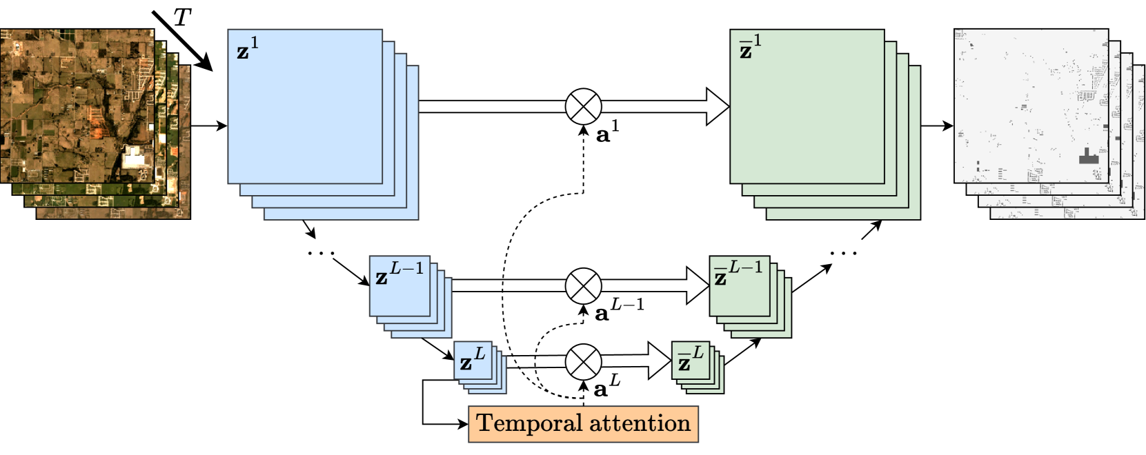
The proposed architecture, called the Satellite Image Time Series Semantic Change Detection (SISTSD) model, consists of several key components:
-
Bitemporal Feature Fusion: The model takes two satellite images captured at different time points as input and uses a feature fusion module to combine the features extracted from each image. This helps the model learn the relationships between the two time points.
-
Self-Supervised Pre-Training: The researchers use a self-supervised learning approach to pre-train the model on auxiliary tasks, such as predicting the time gap between two images or reconstructing the input images. This helps the model learn more generalizable representations of the satellite data.
-
Domain Adaptation: To address the domain shift problem, the researchers incorporate a domain adaptation module that aligns the feature representations between the source and target domains. This helps the model perform well on new datasets or domains it was not trained on.
The researchers evaluate their SISTSD model on several satellite image time series datasets and compare its performance to state-of-the-art change detection models. Their results show that the SISTSD model outperforms these baselines, particularly in scenarios with significant domain shift between the training and testing data.
Critical Analysis
One potential limitation of the SISTSD model is that it relies on having access to pairs of satellite images captured at different time points. In some real-world scenarios, the availability of such bitemporal data may be limited, which could restrict the applicability of the model.
Additionally, the paper does not provide a detailed analysis of the computational complexity or runtime performance of the SISTSD model. This information would be useful for understanding the practical feasibility of deploying the model in real-world applications, especially for large-scale satellite image processing tasks.
Overall, the Rethinking Remote Sensing Change Detection: Mask-View Network for Improved Segmentation and A Reality Check on Change Detection papers offer useful perspectives on the challenges and limitations of change detection in satellite imagery that could complement the insights provided in this work.
Conclusion
The SISTSD model presented in this paper represents a novel and promising approach for addressing the challenge of semantic change detection in satellite image time series data. By incorporating techniques like feature fusion and self-supervised learning, the model demonstrates improved robustness and generalization across different datasets and domains.
The insights and methodologies developed in this work could have important implications for a wide range of applications that rely on monitoring and analyzing changes in the Earth's surface, such as urban planning, natural resource management, and disaster response. As the availability of satellite imagery continues to grow, the need for reliable and adaptable change detection models will only become more critical.
This summary was produced with help from an AI and may contain inaccuracies - check out the links to read the original source documents!
Related Papers
0
Satellite Image Time Series Semantic Change Detection: Novel Architecture and Analysis of Domain Shift
Elliot Vincent, Jean Ponce, Mathieu Aubry
Satellite imagery plays a crucial role in monitoring changes happening on Earth's surface and aiding in climate analysis, ecosystem assessment, and disaster response. In this paper, we tackle semantic change detection with satellite image time series (SITS-SCD) which encompasses both change detection and semantic segmentation tasks. We propose a new architecture that improves over the state of the art, scales better with the number of parameters, and leverages long-term temporal information. However, for practical use cases, models need to adapt to spatial and temporal shifts, which remains a challenge. We investigate the impact of temporal and spatial shifts separately on global, multi-year SITS datasets using DynamicEarthNet and MUDS. We show that the spatial domain shift represents the most complex setting and that the impact of temporal shift on performance is more pronounced on change detection than on semantic segmentation, highlighting that it is a specific issue deserving further attention.
Read more7/11/2024
🤿
0
Deep Learning for Satellite Image Time Series Analysis: A Review
Lynn Miller, Charlotte Pelletier, Geoffrey I. Webb
Earth observation (EO) satellite missions have been providing detailed images about the state of the Earth and its land cover for over 50 years. Long term missions, such as NASA's Landsat, Terra, and Aqua satellites, and more recently, the ESA's Sentinel missions, record images of the entire world every few days. Although single images provide point-in-time data, repeated images of the same area, or satellite image time series (SITS) provide information about the changing state of vegetation and land use. These SITS are useful for modeling dynamic processes and seasonal changes such as plant phenology. They have potential benefits for many aspects of land and natural resource management, including applications in agricultural, forest, water, and disaster management, urban planning, and mining. However, the resulting satellite image time series (SITS) are complex, incorporating information from the temporal, spatial, and spectral dimensions. Therefore, deep learning methods are often deployed as they can analyze these complex relationships. This review presents a summary of the state-of-the-art methods of modelling environmental, agricultural, and other Earth observation variables from SITS data using deep learning methods. We aim to provide a resource for remote sensing experts interested in using deep learning techniques to enhance Earth observation models with temporal information.
Read more4/12/2024
🔎
0
Novel Change Detection Framework in Remote Sensing Imagery Using Diffusion Models and Structural Similarity Index (SSIM)
Andrew Kiruluta, Eric Lundy, Andreas Lemos
Change detection is a crucial task in remote sensing, enabling the monitoring of environmental changes, urban growth, and disaster impact. Conventional change detection techniques, such as image differencing and ratioing, often struggle with noise and fail to capture complex variations in imagery. Recent advancements in machine learning, particularly generative models like diffusion models, offer new opportunities for enhancing change detection accuracy. In this paper, we propose a novel change detection framework that combines the strengths of Stable Diffusion models with the Structural Similarity Index (SSIM) to create robust and interpretable change maps. Our approach, named Diffusion Based Change Detector, is evaluated on both synthetic and real-world remote sensing datasets and compared with state-of-the-art methods. The results demonstrate that our method significantly outperforms traditional differencing techniques and recent deep learning-based methods, particularly in scenarios with complex changes and noise.
Read more8/21/2024

0
A Late-Stage Bitemporal Feature Fusion Network for Semantic Change Detection
Chenyao Zhou, Haotian Zhang, Han Guo, Zhengxia Zou, Zhenwei Shi
Semantic change detection is an important task in geoscience and earth observation. By producing a semantic change map for each temporal phase, both the land use land cover categories and change information can be interpreted. Recently some multi-task learning based semantic change detection methods have been proposed to decompose the task into semantic segmentation and binary change detection subtasks. However, previous works comprise triple branches in an entangled manner, which may not be optimal and hard to adopt foundation models. Besides, lacking explicit refinement of bitemporal features during fusion may cause low accuracy. In this letter, we propose a novel late-stage bitemporal feature fusion network to address the issue. Specifically, we propose local global attentional aggregation module to strengthen feature fusion, and propose local global context enhancement module to highlight pivotal semantics. Comprehensive experiments are conducted on two public datasets, including SECOND and Landsat-SCD. Quantitative and qualitative results show that our proposed model achieves new state-of-the-art performance on both datasets.
Read more6/18/2024