Scrutinizing Data from Sky: An Examination of Its Veracity in Area Based Traffic Contexts
2404.17212
0
0
📊
Abstract
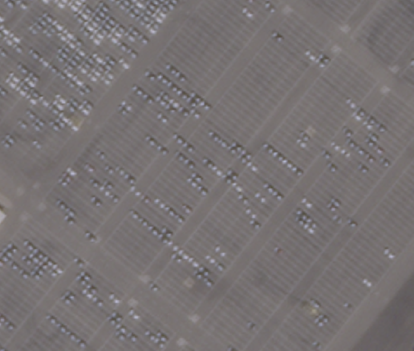
Traffic data collection has been an overwhelming task for researchers as well as authorities over the years. With the advancement in technology and introduction of various tools for processing and extracting traffic data the task has been made significantly convenient. Data from Sky (DFS) is one such tool, based on image processing and artificial intelligence (AI), that provides output for macroscopic as well as microscopic variables of the traffic streams. The company claims to provide 98 to 100 percent accuracy on the data exported using DFS tool. The tool is widely used in developed countries where the traffic is homogenous and has lane-based movements. In this study, authors have checked the veracity of DFS tool in heterogenous and area-based traffic movement that is prevailing in most developing countries. The validation is done using various methods using Classified Volume Count (CVC), Space Mean Speeds (SMS) of individual vehicle classes and microscopic trajectory of probe vehicle to verify DFS claim. The error for CVCs for each vehicle class present in the traffic stream is estimated. Mean Absolute Percentage Error (MAPE) values are calculated for average speeds of each vehicle class between manually and DFS extracted space mean speeds (SMSs), and the microscopic trajectories are validated using a GPS based tracker put on probe vehicles. The results are fairly accurate in the case of data taken from a bird eye view with least errors. The other configurations of data collection have some significant errors, that are majorly caused by the varied traffic composition, the view of camera angle, and the direction of traffic.
Create account to get full access
Overview
- Traffic data collection is a challenging task for researchers and authorities
- Advancements in technology have introduced tools like Data from Sky (DFS) to process and extract traffic data
- DFS is an image processing and AI-based tool that provides data on macroscopic and microscopic traffic variables
- DFS claims 98-100% accuracy, but its performance in heterogeneous, area-based traffic common in developing countries is evaluated in this study
Plain English Explanation
Tracking and understanding traffic patterns is an important but difficult job for people studying transportation and managing roads. Fortunately, new technologies have made this task easier. One such tool is called Data from Sky (DFS), which uses image processing and artificial intelligence to collect detailed information about traffic.
DFS can provide data on broad traffic trends as well as information about individual vehicles. The company behind DFS claims their tool is extremely accurate, reporting 98-100% correct data. However, this study wanted to test how well DFS works in the complex, mixed traffic conditions common in many developing countries, rather than the more organized, lane-based traffic it was designed for.
The researchers used several methods to validate the DFS data, including comparing it to manual counts of different vehicle types, measuring vehicle speeds, and tracking the paths of individual cars. They found the DFS data was quite accurate when collected from a high, overhead viewpoint. But the tool struggled more when the camera angle or traffic composition caused challenges. Overall, the study provides a real-world assessment of this AI-powered traffic monitoring technology.
Technical Explanation
This study evaluates the performance of the Data from Sky (DFS) tool, which uses image processing and artificial intelligence to collect both macroscopic and microscopic data on traffic conditions. DFS is claimed to provide 98-100% accurate outputs, but this research tests its validity in heterogeneous, area-based traffic environments common in developing countries, rather than the more organized, lane-based traffic it was designed for.
The researchers used several validation methods to assess the DFS data:
- Classified Volume Count (CVC): Manually counting the number of vehicles in each class (e.g. cars, trucks, motorcycles) and comparing to the DFS outputs.
- Space Mean Speeds (SMS): Measuring the average speeds of individual vehicle classes and comparing manual and DFS-extracted values.
- Microscopic Trajectory: Tracking the paths of probe vehicles using GPS and comparing to the DFS microscopic data.
The results showed the DFS data was fairly accurate when collected from a high, bird's-eye view, with relatively low errors. However, other data collection configurations had more significant errors, primarily caused by factors like varying traffic composition, camera angle, and traffic flow direction.
This related work on real-time lane-level traffic monitoring highlights similar challenges in extracting accurate traffic data, especially in complex environments. The findings of this DFS validation study provide important insights on the limitations of AI-based traffic monitoring tools in heterogeneous, developing-world traffic conditions.
Critical Analysis
The study provides a thorough, real-world assessment of the DFS tool's performance in a challenging traffic environment. By using multiple validation methods, the researchers were able to identify specific situations where DFS struggled, such as with varied traffic composition and camera angles.
However, the paper does not delve deeply into the underlying reasons for these errors. More investigation into the image processing and AI algorithms used by DFS, and how they handle different traffic scenarios, could have provided additional insights. Other research on comprehensive aircraft detection highlights the importance of understanding algorithm limitations.
Additionally, the study only evaluated DFS in one location. Expanding the testing to additional sites with varying traffic characteristics would strengthen the conclusions and help determine the broader applicability of the findings. Statistical modeling of driving scenarios demonstrates the value of diverse datasets in understanding complex traffic dynamics.
Overall, this is a well-designed study that provides a realistic assessment of an AI-powered traffic monitoring tool. The insights gained can inform the further development and deployment of such technologies, especially in challenging urban environments in the developing world.
Conclusion
This study rigorously evaluated the performance of the Data from Sky (DFS) tool, which uses image processing and AI to collect detailed traffic data. While DFS claims very high accuracy, the researchers found its outputs were most reliable when collected from an overhead, bird's-eye view. In more complex traffic environments with varied vehicle types and camera angles, the DFS data had more significant errors.
These findings highlight the importance of thoroughly validating AI-based technologies, especially when deploying them in real-world conditions that differ from the controlled environments they were designed for. The insights from this study can help guide the future development and deployment of advanced traffic monitoring systems, ensuring they provide reliable, actionable data to transportation researchers and authorities.
The AllTheDocks road safety dataset is another example of how innovative data collection and analysis can improve our understanding of complex transportation challenges. As AI and sensing technologies continue to advance, studies like this one will be crucial for unlocking their full potential to address pressing issues like traffic management in the developing world.
This summary was produced with help from an AI and may contain inaccuracies - check out the links to read the original source documents!
Related Papers
Vehicle Vectors and Traffic Patterns from Planet Imagery
Adam Van Etten
0
0
We explore methods to detect automobiles in Planet imagery and build a large scale vector field for moving objects. Planet operates two distinct constellations: high-resolution SkySat satellites as well as medium-resolution SuperDove satellites. We show that both static and moving cars can be identified reliably in high-resolution SkySat imagery. We are able to estimate the speed and heading of moving vehicles by leveraging the inter-band displacement (or rainbow effect) of moving objects. Identifying cars and trucks in medium-resolution SuperDove imagery is far more difficult, though a similar rainbow effect is observed in these satellites and enables moving vehicles to be detected and vectorized. The frequent revisit of Planet satellites enables the categorization of automobile and truck activity patterns over broad areas of interest and lengthy timeframes.
6/11/2024
📈
Computer vision-based model for detecting turning lane features on Florida's public roadways
Richard Boadu Antwi, Samuel Takyi, Kimollo Michael, Alican Karaer, Eren Erman Ozguven, Ren Moses, Maxim A. Dulebenets, Thobias Sando
0
0
Efficient and current roadway geometry data collection is critical to transportation agencies in road planning, maintenance, design, and rehabilitation. Data collection methods are divided into land-based and aerial-based. Land-based methods for extensive highway networks are tedious, costly, pose safety risks. Therefore, there is the need for efficient, safe, and economical data acquisition methodologies. The rise of computer vision and object detection technologies have made automated extraction of roadway geometry features feasible. This study detects roadway features on Florida's public roads from high-resolution aerial images using AI. The developed model achieved an average accuracy of 80.4 percent when compared with ground truth data. The extracted roadway geometry data can be integrated with crash and traffic data to provide valuable insights to policymakers and roadway users.
6/14/2024
🧪
A Joint Approach Towards Data-Driven Virtual Testing for Automated Driving: The AVEAS Project
Leon Eisemann, Mirjam Fehling-Kaschek, Silke Forkert, Andreas Forster, Henrik Gommel, Susanne Guenther, Stephan Hammer, David Hermann, Marvin Klemp, Benjamin Lickert, Florian Luettner, Robin Moss, Nicole Neis, Maria Pohle, Dominik Schreiber, Cathrina Sowa, Daniel Stadler, Janina Stompe, Michael Strobelt, David Unger, Jens Ziehn
0
0
With growing complexity and responsibility of automated driving functions in road traffic and growing scope of their operational design domains, there is increasing demand for covering significant parts of development, validation, and verification via virtual environments and simulation models. If, however, simulations are meant not only to augment real-world experiments, but to replace them, quantitative approaches are required that measure to what degree and under which preconditions simulation models adequately represent reality, and thus allow their usage for virtual testing of driving functions. Especially in research and development areas related to the safety impacts of the open world, there is a significant shortage of real-world data to parametrize and/or validate simulations - especially with respect to the behavior of human traffic participants, whom automated vehicles will meet in mixed traffic. This paper presents the intermediate results of the German AVEAS research project (www.aveas.org) which aims at developing methods and metrics for the harmonized, systematic, and scalable acquisition of real-world data for virtual verification and validation of advanced driver assistance systems and automated driving, and establishing an online database following the FAIR principles.
5/13/2024
An Approach to Systematic Data Acquisition and Data-Driven Simulation for the Safety Testing of Automated Driving Functions
Leon Eisemann, Mirjam Fehling-Kaschek, Henrik Gommel, David Hermann, Marvin Klemp, Martin Lauer, Benjamin Lickert, Florian Luettner, Robin Moss, Nicole Neis, Maria Pohle, Simon Romanski, Daniel Stadler, Alexander Stolz, Jens Ziehn, Jingxing Zhou
0
0
With growing complexity and criticality of automated driving functions in road traffic and their operational design domains (ODD), there is increasing demand for covering significant proportions of development, validation, and verification in virtual environments and through simulation models. If, however, simulations are meant not only to augment real-world experiments, but to replace them, quantitative approaches are required that measure to what degree and under which preconditions simulation models adequately represent reality, and thus, using their results accordingly. Especially in R&D areas related to the safety impact of the open world, there is a significant shortage of real-world data to parameterize and/or validate simulations - especially with respect to the behavior of human traffic participants, whom automated driving functions will meet in mixed traffic. We present an approach to systematically acquire data in public traffic by heterogeneous means, transform it into a unified representation, and use it to automatically parameterize traffic behavior models for use in data-driven virtual validation of automated driving functions.
5/6/2024