Soil nitrogen forecasting from environmental variables provided by multisensor remote sensing images

0

Sign in to get full access
Overview
- This paper discusses using multisensor remote sensing data to forecast soil nitrogen levels.
- The researchers developed a machine learning model that can predict soil nitrogen content based on environmental variables captured by various satellite and sensor technologies.
- The goal is to provide farmers and agronomists with a way to monitor soil nutrient levels and make more informed decisions about fertilizer application and crop management.
Plain English Explanation
The researchers in this study wanted to find a way to predict how much nitrogen is present in soil without having to physically collect and test soil samples. They used data from different types of satellites and sensors that measure things like temperature, moisture, and vegetation cover. By analyzing this remote sensing data with machine learning algorithms, they were able to create a model that can estimate the nitrogen content of soil.
This is useful because knowing the nutrient levels in soil can help farmers decide how much fertilizer to apply and make other management decisions to maintain soil health and maximize crop yields. Instead of having to go out and take soil samples, which can be time-consuming and expensive, farmers could potentially just look at the results from this model to get an idea of the nitrogen status of their fields.
The ability to monitor soil nutrients using satellite data and AI modeling could be particularly helpful for precision agriculture - an approach that tailors inputs and practices to the specific needs of different areas within a field. This could lead to more efficient and sustainable use of resources like fertilizer.
Technical Explanation
The researchers used multisensor remote sensing data as input features for a machine learning model to predict soil nitrogen content. This included variables like land surface temperature, vegetation indices, and soil moisture derived from satellite imagery and other sensor data.
They tested several different model architectures, including random forests, support vector machines, and neural networks. The neural network models, specifically a convolutional neural network (CNN) and a long short-term memory (LSTM) network, demonstrated the strongest predictive performance.
The CNN model was able to capture spatial relationships in the remote sensing data, while the LSTM could account for temporal dynamics, as soil nitrogen levels can change over the growing season. By combining these two approaches, the researchers developed an integrated CNN-LSTM model that outperformed the individual models.
The CNN-LSTM was able to explain around 80% of the variability in measured soil nitrogen concentrations across the study area, suggesting it is a promising tool for large-scale soil nutrient monitoring compared to traditional field sampling methods.
Critical Analysis
While the results of this study are encouraging, the researchers acknowledge some limitations. The accuracy of the models was still below what would be required for very precise fertilizer recommendations at the field level. Additional research is needed to further improve the predictive power, potentially by incorporating other remote sensing data sources or testing the approach in different geographic regions.
Another concern is the reliance on historical soil sampling data to train and validate the models. This data may not fully capture the spatial and temporal variability of soil nitrogen, and could introduce biases. Deploying these models in new areas without corresponding ground-truth measurements may be challenging.
Overall, this work demonstrates the potential of using machine learning and multisensor remote sensing to monitor soil nutrients at scale. However, continued refinement and validation will be necessary before this approach could be widely adopted by the agricultural community. Careful consideration of the limitations and uncertainties will be important as this technology is developed further.
Conclusion
This study presents a novel approach to forecasting soil nitrogen levels using machine learning models trained on multisensor remote sensing data. By capturing spatial and temporal patterns in environmental variables, the researchers were able to develop a predictive system that could potentially support more sustainable and precision-based crop nutrition management.
While not yet ready for direct on-farm application, this research represents an important step towards leveraging advances in AI and Earth observation to provide farmers with timely, location-specific information about soil health. Further development and validation of these techniques could lead to more efficient use of fertilizers, reduced environmental impacts, and improved crop yields - outcomes that would benefit both farmers and society as a whole.
This summary was produced with help from an AI and may contain inaccuracies - check out the links to read the original source documents!
Related Papers
0
Soil nitrogen forecasting from environmental variables provided by multisensor remote sensing images
Weiying Zhao, Ganzorig Chuluunbat, Aleksei Unagaev, Natalia Efremova
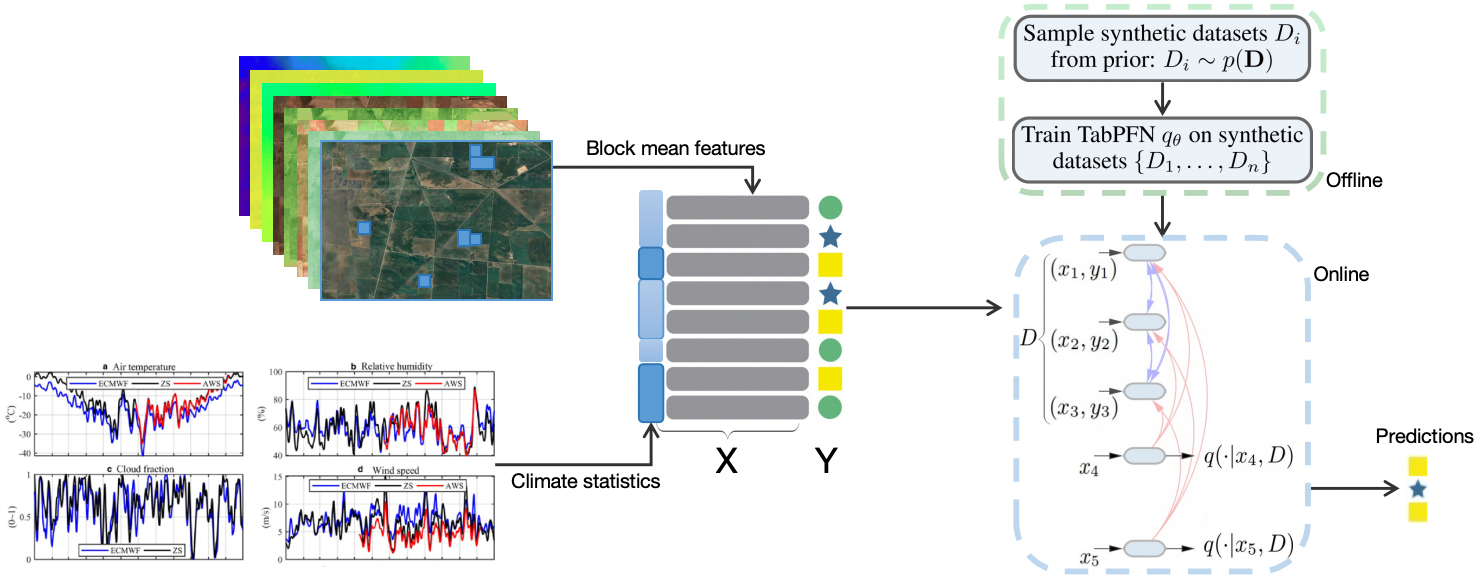
This study introduces a framework for forecasting soil nitrogen content, leveraging multi-modal data, including multi-sensor remote sensing images and advanced machine learning methods. We integrate the Land Use/Land Cover Area Frame Survey (LUCAS) database, which covers European and UK territory, with environmental variables from satellite sensors to create a dataset of novel features. We further test a broad range of machine learning algorithms, focusing on tree-based models such as CatBoost, LightGBM, and XGBoost. We test the proposed methods with a variety of land cover classes, including croplands and grasslands to ensure the robustness of this approach. Our results demonstrate that the CatBoost model surpasses other methods in accuracy. This research advances the field of agricultural management and environmental monitoring and demonstrates the significant potential of integrating multisensor remote sensing data with machine learning for environmental analysis.
Read more6/17/2024
0
Grapevine Disease Prediction Using Climate Variables from Multi-Sensor Remote Sensing Imagery via a Transformer Model
Weiying Zhao, Natalia Efremova
Early detection and management of grapevine diseases are important in pursuing sustainable viticulture. This paper introduces a novel framework leveraging the TabPFN model to forecast blockwise grapevine diseases using climate variables from multi-sensor remote sensing imagery. By integrating advanced machine learning techniques with detailed environmental data, our approach significantly enhances the accuracy and efficiency of disease prediction in vineyards. The TabPFN model's experimental evaluations showcase comparable performance to traditional gradient-boosted decision trees, such as XGBoost, CatBoost, and LightGBM. The model's capability to process complex data and provide per-pixel disease-affecting probabilities enables precise, targeted interventions, contributing to more sustainable disease management practices. Our findings underscore the transformative potential of combining Transformer models with remote sensing data in precision agriculture, offering a scalable solution for improving crop health and productivity while reducing environmental impact.
Read more6/12/2024

0
Urban Air Pollution Forecasting: a Machine Learning Approach leveraging Satellite Observations and Meteorological Forecasts
Giacomo Blanco, Luca Barco, Lorenzo Innocenti, Claudio Rossi
Air pollution poses a significant threat to public health and well-being, particularly in urban areas. This study introduces a series of machine-learning models that integrate data from the Sentinel-5P satellite, meteorological conditions, and topological characteristics to forecast future levels of five major pollutants. The investigation delineates the process of data collection, detailing the combination of diverse data sources utilized in the study. Through experiments conducted in the Milan metropolitan area, the models demonstrate their efficacy in predicting pollutant levels for the forthcoming day, achieving a percentage error of around 30%. The proposed models are advantageous as they are independent of monitoring stations, facilitating their use in areas without existing infrastructure. Additionally, we have released the collected dataset to the public, aiming to stimulate further research in this field. This research contributes to advancing our understanding of urban air quality dynamics and emphasizes the importance of amalgamating satellite, meteorological, and topographical data to develop robust pollution forecasting models.
Read more5/31/2024

0
Explainability of Sub-Field Level Crop Yield Prediction using Remote Sensing
Hiba Najjar, Miro Miranda, Marlon Nuske, Ribana Roscher, Andreas Dengel
Crop yield forecasting plays a significant role in addressing growing concerns about food security and guiding decision-making for policymakers and farmers. When deep learning is employed, understanding the learning and decision-making processes of the models, as well as their interaction with the input data, is crucial for establishing trust in the models and gaining insight into their reliability. In this study, we focus on the task of crop yield prediction, specifically for soybean, wheat, and rapeseed crops in Argentina, Uruguay, and Germany. Our goal is to develop and explain predictive models for these crops, using a large dataset of satellite images, additional data modalities, and crop yield maps. We employ a long short-term memory network and investigate the impact of using different temporal samplings of the satellite data and the benefit of adding more relevant modalities. For model explainability, we utilize feature attribution methods to quantify input feature contributions, identify critical growth stages, analyze yield variability at the field level, and explain less accurate predictions. The modeling results show an improvement when adding more modalities or using all available instances of satellite data. The explainability results reveal distinct feature importance patterns for each crop and region. We further found that the most influential growth stages on the prediction are dependent on the temporal sampling of the input data. We demonstrated how these critical growth stages, which hold significant agronomic value, closely align with the existing literature in agronomy and crop development biology.
Read more7/12/2024