StreamLTS: Query-based Temporal-Spatial LiDAR Fusion for Cooperative Object Detection

0

Sign in to get full access
Overview
- This paper presents StreamLTS, a query-based temporal-spatial LiDAR fusion approach for cooperative object detection.
- The key idea is to leverage the complementary strengths of multiple LiDAR sensors and fuse their data in a temporal-spatial manner to improve object detection performance.
- The approach uses a query-based fusion scheme to efficiently combine the point cloud data from different LiDAR sensors.
Plain English Explanation
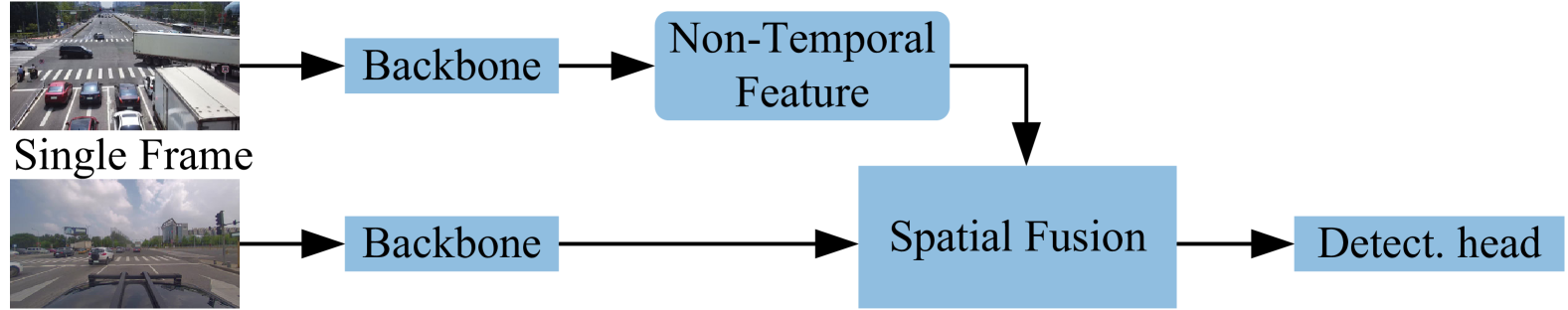
The paper introduces a new method called StreamLTS for improving object detection using multiple LiDAR sensors. LiDAR is a sensing technology that uses laser light to measure distances and create 3D models of the environment.
In many autonomous systems like self-driving cars, multiple LiDAR sensors are used to get a more complete view of the surroundings. However, simply combining the data from these sensors doesn't always work well. StreamLTS aims to fuse the LiDAR data in a more intelligent way.
The key idea is to look at the data from each sensor in both the time domain (how the data changes over time) and the space domain (how it is distributed in 3D space). By considering both the temporal and spatial aspects, StreamLTS can better integrate the complementary information from the different LiDAR sensors.
The paper explains a "query-based" fusion approach where the system actively queries the data from each sensor to find the best way to combine them. This is more efficient than just blindly merging all the data together.
Overall, StreamLTS provides a more effective way to leverage multiple LiDAR sensors for improved object detection, which is crucial for autonomous systems like self-driving cars to understand their surroundings.
Technical Explanation
The paper presents a novel approach called StreamLTS for fusing LiDAR sensor data in a temporal-spatial manner to enable more robust cooperative object detection. The key technical contributions are:
-
Temporal-Spatial LiDAR Fusion: The system models both the temporal and spatial characteristics of the LiDAR point clouds to effectively integrate the complementary information from multiple sensors. This is in contrast to simpler approaches that just combine the raw point cloud data.
-
Query-based Fusion Scheme: Instead of merging all the LiDAR data indiscriminately, StreamLTS uses a query-based fusion strategy. It actively queries the data from each sensor to find the optimal way to fuse the temporal-spatial features for improved object detection.
-
Cooperative Object Detection: By fusing the LiDAR data from multiple vehicles, StreamLTS enables cooperative perception where the vehicles can share information to collectively detect objects in the environment more accurately.
The paper evaluates StreamLTS on both simulated and real-world datasets, demonstrating significant improvements in object detection performance compared to baseline approaches that do not leverage the temporal-spatial fusion or cooperative aspects.
Critical Analysis
The paper presents a well-designed and thoroughly evaluated technical approach for LiDAR fusion and cooperative object detection. The authors demonstrate the effectiveness of their method through extensive experiments.
However, the paper does not discuss some potential limitations or areas for further research. For example, it could be interesting to explore how StreamLTS performs under challenging environmental conditions, such as severe weather or occlusions, where the complementary strengths of the LiDAR sensors may be even more crucial.
Additionally, the paper focuses on object detection, but it may be worthwhile to investigate how the temporal-spatial fusion capabilities of StreamLTS could be extended to other perception tasks, such as semantic segmentation or instance tracking.
Overall, the work represents a significant contribution to the field of cooperative perception for autonomous systems, and the ideas presented in the paper could inspire further research in this important area.
Conclusion
This paper introduces StreamLTS, a novel query-based temporal-spatial LiDAR fusion approach for cooperative object detection. By modeling both the temporal and spatial characteristics of the LiDAR data and using a smart fusion strategy, StreamLTS can effectively leverage the complementary strengths of multiple LiDAR sensors to improve object detection performance.
The key innovation is the temporal-spatial fusion scheme and the query-based fusion strategy, which enable more robust and efficient integration of the LiDAR data. This is a crucial capability for autonomous systems like self-driving cars, where accurate perception of the surrounding environment is essential for safe navigation.
The paper's thorough experimental evaluation demonstrates the significant advantages of StreamLTS over baseline approaches, highlighting its potential to advance the state-of-the-art in cooperative perception for autonomous systems.
This summary was produced with help from an AI and may contain inaccuracies - check out the links to read the original source documents!
Related Papers
0
StreamLTS: Query-based Temporal-Spatial LiDAR Fusion for Cooperative Object Detection
Yunshuang Yuan, Monika Sester
Cooperative perception via communication among intelligent traffic agents has great potential to improve the safety of autonomous driving. However, limited communication bandwidth, localization errors and asynchronized capturing time of sensor data, all introduce difficulties to the data fusion of different agents. To some extend, previous works have attempted to reduce the shared data size, mitigate the spatial feature misalignment caused by localization errors and communication delay. However, none of them have considered the asynchronized sensor ticking times, which can lead to dynamic object misplacement of more than one meter during data fusion. In this work, we propose Time-Aligned COoperative Object Detection (TA-COOD), for which we adapt widely used dataset OPV2V and DairV2X with considering asynchronous LiDAR sensor ticking times and build an efficient fully sparse framework with modeling the temporal information of individual objects with query-based techniques. The experiment results confirmed the superior efficiency of our fully sparse framework compared to the state-of-the-art dense models. More importantly, they show that the point-wise observation timestamps of the dynamic objects are crucial for accurate modeling the object temporal context and the predictability of their time-related locations. The official code is available at url{https://github.com/YuanYunshuang/CoSense3D}.
Read more8/23/2024

0
Velocity Driven Vision: Asynchronous Sensor Fusion Birds Eye View Models for Autonomous Vehicles
Seamie Hayes, Sushil Sharma, Ciar'an Eising
Fusing different sensor modalities can be a difficult task, particularly if they are asynchronous. Asynchronisation may arise due to long processing times or improper synchronisation during calibration, and there must exist a way to still utilise this previous information for the purpose of safe driving, and object detection in ego vehicle/ multi-agent trajectory prediction. Difficulties arise in the fact that the sensor modalities have captured information at different times and also at different positions in space. Therefore, they are not spatially nor temporally aligned. This paper will investigate the challenge of radar and LiDAR sensors being asynchronous relative to the camera sensors, for various time latencies. The spatial alignment will be resolved before lifting into BEV space via the transformation of the radar/LiDAR point clouds into the new ego frame coordinate system. Only after this can we concatenate the radar/LiDAR point cloud and lifted camera features. Temporal alignment will be remedied for radar data only, we will implement a novel method of inferring the future radar point positions using the velocity information. Our approach to resolving the issue of sensor asynchrony yields promising results. We demonstrate velocity information can drastically improve IoU for asynchronous datasets, as for a time latency of 360 milliseconds (ms), IoU improves from 49.54 to 53.63. Additionally, for a time latency of 550ms, the camera+radar (C+R) model outperforms the camera+LiDAR (C+L) model by 0.18 IoU. This is an advancement in utilising the often-neglected radar sensor modality, which is less favoured than LiDAR for autonomous driving purposes.
Read more7/25/2024

0
Future Does Matter: Boosting 3D Object Detection with Temporal Motion Estimation in Point Cloud Sequences
Rui Yu, Runkai Zhao, Cong Nie, Heng Wang, HuaiCheng Yan, Meng Wang
Accurate and robust LiDAR 3D object detection is essential for comprehensive scene understanding in autonomous driving. Despite its importance, LiDAR detection performance is limited by inherent constraints of point cloud data, particularly under conditions of extended distances and occlusions. Recently, temporal aggregation has been proven to significantly enhance detection accuracy by fusing multi-frame viewpoint information and enriching the spatial representation of objects. In this work, we introduce a novel LiDAR 3D object detection framework, namely LiSTM, to facilitate spatial-temporal feature learning with cross-frame motion forecasting information. We aim to improve the spatial-temporal interpretation capabilities of the LiDAR detector by incorporating a dynamic prior, generated from a non-learnable motion estimation model. Specifically, Motion-Guided Feature Aggregation (MGFA) is proposed to utilize the object trajectory from previous and future motion states to model spatial-temporal correlations into gaussian heatmap over a driving sequence. This motion-based heatmap then guides the temporal feature fusion, enriching the proposed object features. Moreover, we design a Dual Correlation Weighting Module (DCWM) that effectively facilitates the interaction between past and prospective frames through scene- and channel-wise feature abstraction. In the end, a cascade cross-attention-based decoder is employed to refine the 3D prediction. We have conducted experiments on the Waymo and nuScenes datasets to demonstrate that the proposed framework achieves superior 3D detection performance with effective spatial-temporal feature learning.
Read more9/9/2024
0
Leveraging Temporal Contexts to Enhance Vehicle-Infrastructure Cooperative Perception
Jiaru Zhong, Haibao Yu, Tianyi Zhu, Jiahui Xu, Wenxian Yang, Zaiqing Nie, Chao Sun
Infrastructure sensors installed at elevated positions offer a broader perception range and encounter fewer occlusions. Integrating both infrastructure and ego-vehicle data through V2X communication, known as vehicle-infrastructure cooperation, has shown considerable advantages in enhancing perception capabilities and addressing corner cases encountered in single-vehicle autonomous driving. However, cooperative perception still faces numerous challenges, including limited communication bandwidth and practical communication interruptions. In this paper, we propose CTCE, a novel framework for cooperative 3D object detection. This framework transmits queries with temporal contexts enhancement, effectively balancing transmission efficiency and performance to accommodate real-world communication conditions. Additionally, we propose a temporal-guided fusion module to further improve performance. The roadside temporal enhancement and vehicle-side spatial-temporal fusion together constitute a multi-level temporal contexts integration mechanism, fully leveraging temporal information to enhance performance. Furthermore, a motion-aware reconstruction module is introduced to recover lost roadside queries due to communication interruptions. Experimental results on V2X-Seq and V2X-Sim datasets demonstrate that CTCE outperforms the baseline QUEST, achieving improvements of 3.8% and 1.3% in mAP, respectively. Experiments under communication interruption conditions validate CTCE's robustness to communication interruptions.
Read more8/21/2024