XAI-Guided Enhancement of Vegetation Indices for Crop Mapping

0
Sign in to get full access
Overview
- This paper proposes a method to enhance vegetation indices for improved crop mapping using eXplainable Artificial Intelligence (XAI) techniques.
- The authors leverage XAI to identify important spectral features and guide the development of new, enhanced vegetation indices.
- The proposed approach is evaluated on a dataset of hyperspectral images and validated against existing vegetation indices.
Plain English Explanation
The paper focuses on improving how we use satellite imagery to map and identify different crops in agricultural areas. Traditionally, scientists have relied on a set of standard "vegetation indices" - mathematical formulas that combine different color bands in the imagery to highlight the presence of plants. However, these standard indices don't always work well for distinguishing between different crop types.
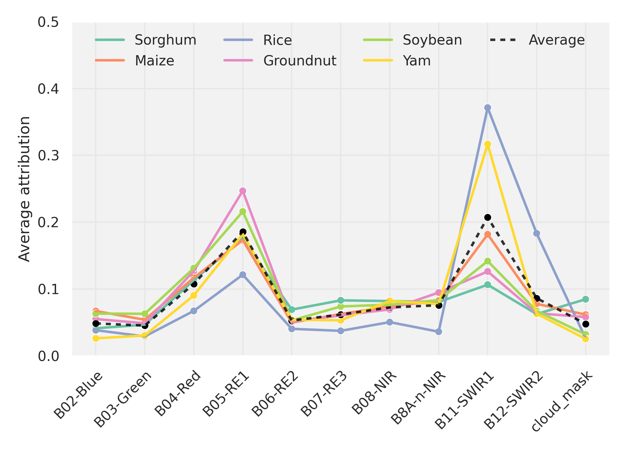
The researchers in this study used a technique called eXplainable AI (or XAI) to analyze the satellite imagery and identify which specific color bands and combinations are most important for detecting different crops. [1] By understanding these key spectral features, they were able to design new, enhanced vegetation indices that outperformed the standard ones.
The basic idea is that the XAI analysis acts like a guide, pointing the researchers towards the most informative parts of the satellite data for crop mapping. This allows them to create more tailored and effective tools for this real-world application, beyond what the generic vegetation indices can provide.
Technical Explanation
The authors propose an XAI-guided approach to enhance vegetation indices for improved crop mapping from hyperspectral satellite imagery. [2] First, they train a deep learning model to classify different crop types based on the spectral data. They then use XAI techniques, such as layer-wise relevance propagation, to identify the most important spectral features for the classification.
Armed with this XAI-derived knowledge, the researchers develop new, customized vegetation indices by combining the most informative spectral bands. These enhanced indices are then evaluated against standard vegetation indices on the crop classification task. The results demonstrate that the XAI-guided indices significantly outperform the existing ones, highlighting their potential for improved agricultural monitoring and management.
Critical Analysis
The key strength of this work is its use of XAI to guide the development of more effective vegetation indices. By identifying the critical spectral features for crop discrimination, the authors are able to move beyond the limitations of generic indices and create more targeted tools. This is an important contribution, as accurate and reliable crop mapping is essential for precision agriculture, food security, and environmental monitoring.
That said, the paper does not fully address the potential limitations or caveats of the proposed approach. For example, the performance of the XAI-guided indices may be dependent on the specific dataset and crop types studied. Further research is needed to evaluate their generalizability to other regions and agricultural systems. [3] Additionally, the interpretability and explainability of the XAI techniques themselves could be explored in more depth.
Conclusion
This paper presents a novel XAI-guided method for enhancing vegetation indices for improved crop mapping from hyperspectral satellite imagery. By leveraging XAI to identify key spectral features, the researchers are able to develop customized indices that outperform standard approaches. This work demonstrates the value of incorporating eXplainable AI into the development of remote sensing applications, with potential benefits for precision agriculture, food security, and environmental management.
[1] https://aimodels.fyi/papers/arxiv/dual-band-feature-selection-maturity-classification-specialty [2] https://aimodels.fyi/papers/arxiv/spectral-image-data-fusion-multisource-data-augmentation [3] https://aimodels.fyi/papers/arxiv/comparative-analysis-hyperspectral-image-reconstruction-using-deep
This summary was produced with help from an AI and may contain inaccuracies - check out the links to read the original source documents!
Related Papers
0
XAI-Guided Enhancement of Vegetation Indices for Crop Mapping
Hiba Najjar, Francisco Mena, Marlon Nuske, Andreas Dengel
Vegetation indices allow to efficiently monitor vegetation growth and agricultural activities. Previous generations of satellites were capturing a limited number of spectral bands, and a few expert-designed vegetation indices were sufficient to harness their potential. New generations of multi- and hyperspectral satellites can however capture additional bands, but are not yet efficiently exploited. In this work, we propose an explainable-AI-based method to select and design suitable vegetation indices. We first train a deep neural network using multispectral satellite data, then extract feature importance to identify the most influential bands. We subsequently select suitable existing vegetation indices or modify them to incorporate the identified bands and retrain our model. We validate our approach on a crop classification task. Our results indicate that models trained on individual indices achieve comparable results to the baseline model trained on all bands, while the combination of two indices surpasses the baseline in certain cases.
Read more7/12/2024
📊
0
Estimating optical vegetation indices and biophysical variables for temperate forests with Sentinel-1 SAR data using machine learning techniques: A case study for Czechia
Daniel Paluba, Bertrand Le Saux, Pv{r}emysl Stych
Current optical vegetation indices (VIs) for monitoring forest ecosystems are well established and widely used in various applications, but can be limited by atmospheric effects such as clouds. In contrast, synthetic aperture radar (SAR) data can offer insightful and systematic forest monitoring with complete time series (TS) due to signal penetration through clouds and day and night image acquisitions. This study aims to address the limitations of optical satellite data by using SAR data as an alternative for estimating optical VIs for forests through machine learning (ML). While this approach is less direct and likely only feasible through the power of ML, it raises the scientific question of whether enough relevant information is contained in the SAR signal to accurately estimate VIs. This work covers the estimation of TS of four VIs (LAI, FAPAR, EVI and NDVI) using multitemporal Sentinel-1 SAR and ancillary data. The study focused on both healthy and disturbed temperate forest areas in Czechia for the year 2021, while ground truth labels generated from Sentinel-2 multispectral data. This was enabled by creating a paired multi-modal TS dataset in Google Earth Engine (GEE), including temporally and spatially aligned Sentinel-1, Sentinel-2, DEM, weather and land cover datasets. The inclusion of DEM-derived auxiliary features and additional meteorological information, further improved the results. In the comparison of ML models, the traditional ML algorithms, RFR and XGBoost slightly outperformed the AutoML approach, auto-sklearn, for all VIs, achieving high accuracies ($R^2$ between 70-86%) and low errors (0.055-0.29 of MAE). In general, up to 240 measurements per year and a spatial resolution of 20 m can be achieved using estimated SAR-based VIs with high accuracy. A great advantage of the SAR-based VI is the ability to detect abrupt forest changes with sub-weekly temporal accuracy.
Read more8/28/2024
0
Dual-band feature selection for maturity classification of specialty crops by hyperspectral imaging
Usman A. Zahidi, Krystian {L}ukasik, Grzegorz Cielniak
The maturity classification of specialty crops such as strawberries and tomatoes is an essential agricultural downstream activity for selective harvesting and quality control (QC) at production and packaging sites. Recent advancements in Deep Learning (DL) have produced encouraging results in color images for maturity classification applications. However, hyperspectral imaging (HSI) outperforms methods based on color vision. Multivariate analysis methods and Convolutional Neural Networks (CNN) deliver promising results; however, a large amount of input data and the associated preprocessing requirements cause hindrances in practical application. Conventionally, the reflectance intensity in a given electromagnetic spectrum is employed in estimating fruit maturity. We present a feature extraction method to empirically demonstrate that the peak reflectance in subbands such as 500-670 nm (pigment band) and the wavelength of the peak position, and contrarily, the trough reflectance and its corresponding wavelength within 671-790 nm (chlorophyll band) are convenient to compute yet distinctive features for the maturity classification. The proposed feature selection method is beneficial because preprocessing, such as dimensionality reduction, is avoided before every prediction. The feature set is designed to capture these traits. The best SOTA methods, among 3D-CNN, 1D-CNN, and SVM, achieve at most 90.0 % accuracy for strawberries and 92.0 % for tomatoes on our dataset. Results show that the proposed method outperforms the SOTA as it yields an accuracy above 98.0 % in strawberry and 96.0 % in tomato classification. A comparative analysis of the time efficiency of these methods is also conducted, which shows the proposed method performs prediction at 13 Frames Per Second (FPS) compared to the maximum 1.16 FPS attained by the full-spectrum SVM classifier.
Read more5/20/2024
🖼️
0
Spectral Image Data Fusion for Multisource Data Augmentation
Roberta Iuliana Luca, Alexandra Baicoianu, Ioana Cristina Plajer
Multispectral and hyperspectral images are increasingly popular in different research fields, such as remote sensing, astronomical imaging, or precision agriculture. However, the amount of free data available to perform machine learning tasks is relatively small. Moreover, artificial intelligence models developed in the area of spectral imaging require input images with a fixed spectral signature, expecting the data to have the same number of spectral bands or the same spectral resolution. This requirement significantly reduces the number of usable sources that can be used for a given model. The scope of this study is to introduce a methodology for spectral image data fusion, in order to allow machine learning models to be trained and/or used on data from a larger number of sources, thus providing better generalization. For this purpose, we propose different interpolation techniques, in order to make multisource spectral data compatible with each other. The interpolation outcomes are evaluated through various approaches. This includes direct assessments using surface plots and metrics such as a Custom Mean Squared Error (CMSE) and the Normalized Difference Vegetation Index (NDVI). Additionally, indirect evaluation is done by estimating their impact on machine learning model training, particularly for semantic segmentation.
Read more5/27/2024