AI for operational methane emitter monitoring from space

0

Sign in to get full access
Overview
- The paper discusses the use of AI for monitoring methane emissions from space.
- The researchers developed a deep learning model to automatically detect and quantify methane plumes from satellite imagery.
- The model was trained on a large dataset of methane emissions data and was able to achieve high accuracy in identifying and measuring methane plumes.
- The researchers suggest that this technology could be used for real-time monitoring of methane emissions from industrial sources, helping to mitigate climate change.
Plain English Explanation
The paper describes a new AI technique that can help track methane emissions from space. Methane is a powerful greenhouse gas that contributes to climate change, so it's important to be able to monitor where it's being released.
The researchers built a deep learning model that can analyze satellite images and automatically detect methane plumes. They trained the model on a large dataset of methane emissions data, teaching it to recognize the distinctive patterns and signatures of methane in the imagery.
Once trained, the model was able to accurately identify and measure methane plumes from the satellite data. The researchers suggest that this technology could be used for real-time monitoring of industrial methane sources, allowing for faster detection and mitigation of these emissions. This could play an important role in the fight against climate change by helping to reduce a major source of greenhouse gases.
Technical Explanation
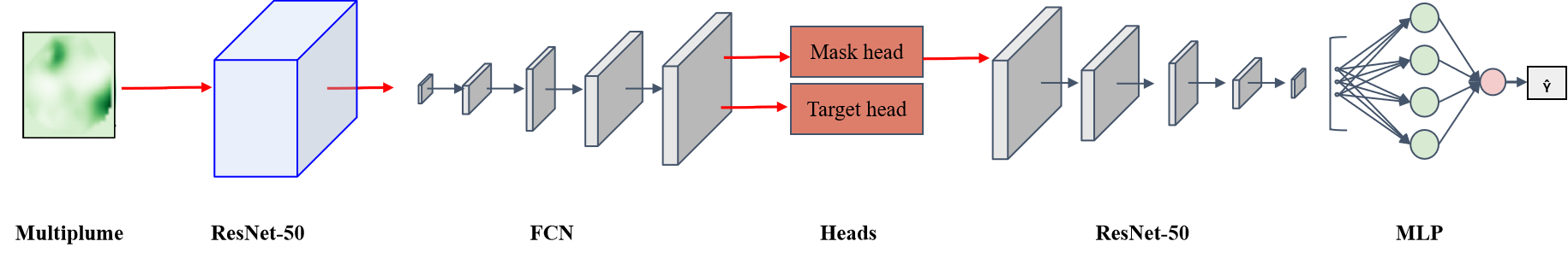
The paper presents a deep learning framework for the automated detection and quantification of methane plumes from satellite remote sensing data. The researchers developed a convolutional neural network (CNN) model that takes satellite imagery as input and outputs the location, size, and concentration of methane plumes.
To train the model, the researchers compiled a large dataset of methane emissions data from various sources, including ground-based measurements, air surveys, and satellite observations. They used this data to create realistic synthetic satellite images with simulated methane plumes, which were then used to train the CNN model.
The trained model was able to accurately identify and measure methane plumes in real satellite imagery, achieving a high degree of precision and recall. The researchers demonstrated the model's performance on a variety of test cases, including both controlled experiments and real-world emissions events.
The key technical innovation of this work is the use of deep learning to automate the process of methane detection and quantification from satellite data. This represents a significant advance over traditional manual or semi-automated approaches, which are labor-intensive and can be prone to errors.
Critical Analysis
The researchers acknowledge several limitations and areas for future work. First, the model was trained on simulated data, and its performance on real-world satellite imagery may be affected by factors like atmospheric conditions, sensor noise, and spatial resolution. Further validation on a broader range of real-world data would be necessary to fully assess the model's capabilities.
Additionally, the model currently operates on a per-image basis and does not take into account the temporal dynamics of methane plumes. Incorporating time-series analysis could improve the model's ability to track the evolution of emissions events and distinguish between persistent and transient sources.
The researchers also note that the model's output is limited to the location, size, and concentration of methane plumes. Integrating this information with other data sources, such as wind and weather patterns, could provide a more comprehensive understanding of emissions sources and atmospheric transport.
Overall, the researchers have demonstrated a promising approach to automating the detection and quantification of methane emissions from space. With further development and validation, this technology could become a valuable tool for near-real-time monitoring and mitigation of a significant source of greenhouse gases.
Conclusion
This paper presents a novel deep learning framework for the automated detection and measurement of methane plumes from satellite imagery. The researchers developed a CNN model that can accurately identify and quantify methane emissions, representing a significant advance over traditional manual approaches.
The potential impact of this technology is significant, as it could enable real-time monitoring and mitigation of methane emissions, a major contributor to climate change. By providing a scalable and reliable way to track methane sources from space, this work could inform policy decisions and drive efforts to reduce greenhouse gas emissions.
While the model has shown promising results, further research is needed to fully validate its performance in real-world conditions and explore ways to integrate it with other data sources for a more comprehensive understanding of emissions dynamics. Nonetheless, this paper represents an important step forward in the application of AI techniques to the critical challenge of monitoring and mitigating climate change.
This summary was produced with help from an AI and may contain inaccuracies - check out the links to read the original source documents!
Related Papers
0
AI for operational methane emitter monitoring from space
Anna Vaughan, Gonzalo Mateo-Garcia, Itziar Irakulis-Loitxate, Marc Watine, Pablo Fernandez-Poblaciones, Richard E. Turner, James Requeima, Javier Gorro~no, Cynthia Randles, Manfredi Caltagirone, Claudio Cifarelli
Mitigating methane emissions is the fastest way to stop global warming in the short-term and buy humanity time to decarbonise. Despite the demonstrated ability of remote sensing instruments to detect methane plumes, no system has been available to routinely monitor and act on these events. We present MARS-S2L, an automated AI-driven methane emitter monitoring system for Sentinel-2 and Landsat satellite imagery deployed operationally at the United Nations Environment Programme's International Methane Emissions Observatory. We compile a global dataset of thousands of super-emission events for training and evaluation, demonstrating that MARS-S2L can skillfully monitor emissions in a diverse range of regions globally, providing a 216% improvement in mean average precision over a current state-of-the-art detection method. Running this system operationally for six months has yielded 457 near-real-time detections in 22 different countries of which 62 have already been used to provide formal notifications to governments and stakeholders.
Read more8/12/2024

0
Machine Learning for Methane Detection and Quantification from Space -- A survey
Enno Tiemann, Shanyu Zhou, Alexander Klaser, Konrad Heidler, Rochelle Schneider, Xiao Xiang Zhu
Methane (CH_4) is a potent anthropogenic greenhouse gas, contributing 86 times more to global warming than Carbon Dioxide (CO_2) over 20 years, and it also acts as an air pollutant. Given its high radiative forcing potential and relatively short atmospheric lifetime (9textpm1 years), methane has important implications for climate change, therefore, cutting methane emissions is crucial for effective climate change mitigation. This work expands existing information on operational methane point source detection sensors in the Short-Wave Infrared (SWIR) bands. It reviews the state-of-the-art for traditional as well as Machine Learning (ML) approaches. The architecture and data used in such ML models will be discussed separately for methane plume segmentation and emission rate estimation. Traditionally, experts rely on labor-intensive manually adjusted methods for methane detection. However, ML approaches offer greater scalability. Our analysis reveals that ML models outperform traditional methods, particularly those based on convolutional neural networks (CNN), which are based on the U-net and transformer architectures. These ML models extract valuable information from methane-sensitive spectral data, enabling a more accurate detection. Challenges arise when comparing these methods due to variations in data, sensor specifications, and evaluation metrics. To address this, we discuss existing datasets and metrics, providing an overview of available resources and identifying open research problems. Finally, we explore potential future advances in ML, emphasizing approaches for model comparability, large dataset creation, and the European Union's forthcoming methane strategy.
Read more8/28/2024
0
Unlocking the Potential: Multi-task Deep Learning for Spaceborne Quantitative Monitoring of Fugitive Methane Plumes
Guoxin Si, Shiliang Fu, Wei Yao
As global warming intensifies, increased attention is being paid to monitoring fugitive methane emissions and detecting gas plumes from landfills. We have divided methane emission monitoring into three subtasks: methane concentration inversion, plume segmentation, and emission rate estimation. Traditional algorithms face certain limitations: methane concentration inversion typically employs the matched filter, which is sensitive to the global spectrum distribution and prone to significant noise. There is scant research on plume segmentation, with many studies depending on manual segmentation, which can be subjective. The estimation of methane emission rate frequently uses the IME algorithm, which necessitates meteorological measurement data. Utilizing the WENT landfill site in Hong Kong along with PRISMA hyperspectral satellite imagery, we introduce a novel deep learning-based framework for quantitative methane emission monitoring from remote sensing images that is grounded in physical simulation. We create simulated methane plumes using large eddy simulation (LES) and various concentration maps of fugitive emissions using the radiative transfer equation (RTE), while applying augmentation techniques to construct a simulated PRISMA dataset. We train a U-Net network for methane concentration inversion, a Mask R-CNN network for methane plume segmentation, and a ResNet-50 network for methane emission rate estimation. All three deep networks yield higher validation accuracy compared to traditional algorithms. Furthermore, we combine the first two subtasks and the last two subtasks to design multi-task learning models, MTL-01 and MTL-02, both of which outperform single-task models in terms of accuracy. Our research exemplifies the application of multi-task deep learning to quantitative methane monitoring and can be generalized to a wide array of methane monitoring tasks.
Read more7/16/2024
➖
0
Unlocking the Use of Raw Multispectral Earth Observation Imagery for Onboard Artificial Intelligence
Gabriele Meoni, Roberto Del Prete, Federico Serva, Alix De Beussche, Olivier Colin, Nicolas Long'ep'e
Nowadays, there is growing interest in applying Artificial Intelligence (AI) on board Earth Observation (EO) satellites for time-critical applications, such as natural disaster response. However, the unavailability of raw satellite data currently hinders research on lightweight pre-processing techniques and limits the exploration of end-to-end pipelines, which could offer more efficient and accurate extraction of insights directly from the source data. To fill this gap, this work presents a novel methodology to automate the creation of datasets for the detection of target events (e.g., warm thermal hotspots) or objects (e.g., vessels) from Sentinel-2 raw data and other multispectral EO pushbroom raw imagery. The presented approach first processes the raw data by applying a pipeline consisting of spatial band registration and georeferencing of the raw data pixels. Then, it detects the target events by leveraging event-specific state-of-the-art algorithms on the Level-1C products, which are mosaicked and cropped on the georeferenced correspondent raw granule area. The detected events are finally re-projected back onto the corresponding raw images. We apply the proposed methodology to realize THRawS (Thermal Hotspots in Raw Sentinel-2 data), the first dataset of Sentinel-2 raw data containing warm thermal hotspots. THRawS includes 1090 samples containing wildfires, volcanic eruptions, and 33,335 event-free acquisitions to enable thermal hotspot detection and general classification applications. This dataset and associated toolkits provide the community with both an immediately useful resource as well as a framework and methodology acting as a template for future additions. With this work, we hope to pave the way for research on energy-efficient pre-processing algorithms and AI-based end-to-end processing systems on board EO satellites.
Read more9/11/2024