Black carbon plumes from gas flaring in North Africa identified from multi-spectral imagery with deep learning

0
Sign in to get full access
Overview
- This paper identifies black carbon plumes from gas flaring in North Africa using multi-spectral satellite imagery and deep learning techniques.
- The researchers developed a deep learning model to automatically detect and map these plumes, which are a significant source of air pollution and greenhouse gas emissions.
- The method provides a scalable approach to monitoring and quantifying gas flaring activity in remote regions where on-the-ground measurements are challenging.
Plain English Explanation
The paper focuses on a major environmental issue: gas flaring, the burning of excess natural gas that is released during oil and gas production. This practice is common in parts of Africa and releases large amounts of black carbon, a type of particulate pollution that is harmful to human health and the climate.
To address this problem, the researchers used satellite imagery that captures different wavelengths of light. They trained a deep learning model to analyze this multi-spectral data and automatically detect the black carbon plumes from gas flaring activities. This allows them to map the location and extent of these plumes across a wide region, without the need for expensive on-site monitoring.
By identifying and quantifying the gas flaring activities, this research can help policymakers and companies take steps to reduce these harmful emissions. The method provides a scalable and cost-effective way to monitor a significant source of air pollution and greenhouse gases, particularly in remote areas where ground-based measurements are challenging.
Technical Explanation
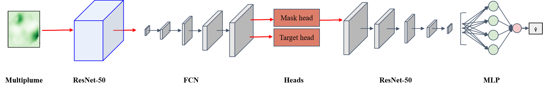
The researchers developed a deep learning-based approach to detect and map black carbon plumes from gas flaring activities in North Africa using multi-spectral satellite imagery. They used data from the Sentinel-2 satellite, which captures light at multiple wavelengths across the visible and infrared spectrum.
The key elements of their methodology include:
-
Data Preprocessing: The satellite imagery was preprocessed to correct for atmospheric effects and to extract relevant features like surface reflectance and temperature.
-
Deep Learning Model: The researchers trained a convolutional neural network (CNN) model to automatically identify the characteristic spectral signatures of black carbon plumes in the multi-spectral data. This allows the model to detect the plumes with high accuracy.
-
Plume Mapping: By applying the trained model to the satellite imagery, the researchers were able to map the location and extent of black carbon plumes across the study region in North Africa. This provides a comprehensive view of gas flaring activities.
The key insights from this research include the ability to scale up monitoring of gas flaring using remote sensing data, as well as the potential to quantify the emissions from these activities and track changes over time. This information can support efforts to reduce the environmental impact of gas flaring in the region.
Critical Analysis
The paper presents a robust and innovative approach to detecting and mapping a significant source of air pollution and greenhouse gas emissions. The use of multi-spectral satellite imagery and deep learning techniques allows for a scalable and automated monitoring system, overcoming the limitations of ground-based measurements in remote regions.
However, the authors acknowledge that the accuracy of the plume detection may be affected by factors like cloud cover and atmospheric conditions. Additionally, the model was trained and validated on data from a specific region in North Africa, so its performance in other parts of the world would need to be evaluated.
Further research could explore ways to integrate the plume detection with other data sources, such as oil and gas production records, to provide a more comprehensive understanding of the emissions and their drivers. There is also scope to refine the model architecture and training strategies to improve the detection accuracy and robustness.
Conclusion
This research demonstrates the potential of remote sensing and deep learning techniques to address the critical environmental issue of gas flaring. By developing a scalable method to monitor black carbon plumes, the researchers have provided a valuable tool for policymakers and industry stakeholders to quantify and mitigate these harmful emissions.
The findings have broader implications for the use of advanced analytical methods to tackle complex environmental challenges, particularly in regions where on-the-ground data collection is limited. As the world works towards a more sustainable future, innovative approaches like the one presented in this paper will be crucial for driving informed decision-making and effective climate action.
This summary was produced with help from an AI and may contain inaccuracies - check out the links to read the original source documents!
Related Papers
0
Black carbon plumes from gas flaring in North Africa identified from multi-spectral imagery with deep learning
Tuel Alexandre, Kerdreux Thomas, Thiry Louis
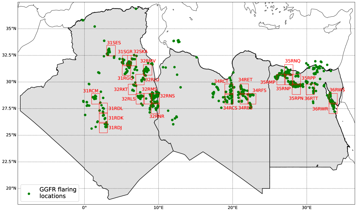
Black carbon (BC) is an important pollutant aerosol emitted by numerous human activities, including gas flaring. Improper combustion in flaring activities can release large amounts of BC, which is harmful to human health and has a strong climate warming effect. To our knowledge, no study has ever directly monitored BC emissions from satellite imagery. Previous works quantified BC emissions indirectly, by applying emission coefficients to flaring volumes estimated from satellite imagery. Here, we develop a deep learning framework and apply it to Sentinel-2 imagery over North Africa during 2022 to detect and quantify BC emissions from gas flaring. We find that BC emissions in this region amount to about 1 million tCO$_{2,mathrm{eq}}$, or 1 million passenger cars, more than a quarter of which are due to 10 sites alone. This work demonstrates the operational monitoring of BC emissions from flaring, a key step in implementing effective mitigation policies to reduce the climate impact of oil and gas operations.
Read more6/11/2024

0
AI for operational methane emitter monitoring from space
Anna Vaughan, Gonzalo Mateo-Garcia, Itziar Irakulis-Loitxate, Marc Watine, Pablo Fernandez-Poblaciones, Richard E. Turner, James Requeima, Javier Gorro~no, Cynthia Randles, Manfredi Caltagirone, Claudio Cifarelli
Mitigating methane emissions is the fastest way to stop global warming in the short-term and buy humanity time to decarbonise. Despite the demonstrated ability of remote sensing instruments to detect methane plumes, no system has been available to routinely monitor and act on these events. We present MARS-S2L, an automated AI-driven methane emitter monitoring system for Sentinel-2 and Landsat satellite imagery deployed operationally at the United Nations Environment Programme's International Methane Emissions Observatory. We compile a global dataset of thousands of super-emission events for training and evaluation, demonstrating that MARS-S2L can skillfully monitor emissions in a diverse range of regions globally, providing a 216% improvement in mean average precision over a current state-of-the-art detection method. Running this system operationally for six months has yielded 457 near-real-time detections in 22 different countries of which 62 have already been used to provide formal notifications to governments and stakeholders.
Read more8/12/2024
0
Unlocking the Potential: Multi-task Deep Learning for Spaceborne Quantitative Monitoring of Fugitive Methane Plumes
Guoxin Si, Shiliang Fu, Wei Yao
As global warming intensifies, increased attention is being paid to monitoring fugitive methane emissions and detecting gas plumes from landfills. We have divided methane emission monitoring into three subtasks: methane concentration inversion, plume segmentation, and emission rate estimation. Traditional algorithms face certain limitations: methane concentration inversion typically employs the matched filter, which is sensitive to the global spectrum distribution and prone to significant noise. There is scant research on plume segmentation, with many studies depending on manual segmentation, which can be subjective. The estimation of methane emission rate frequently uses the IME algorithm, which necessitates meteorological measurement data. Utilizing the WENT landfill site in Hong Kong along with PRISMA hyperspectral satellite imagery, we introduce a novel deep learning-based framework for quantitative methane emission monitoring from remote sensing images that is grounded in physical simulation. We create simulated methane plumes using large eddy simulation (LES) and various concentration maps of fugitive emissions using the radiative transfer equation (RTE), while applying augmentation techniques to construct a simulated PRISMA dataset. We train a U-Net network for methane concentration inversion, a Mask R-CNN network for methane plume segmentation, and a ResNet-50 network for methane emission rate estimation. All three deep networks yield higher validation accuracy compared to traditional algorithms. Furthermore, we combine the first two subtasks and the last two subtasks to design multi-task learning models, MTL-01 and MTL-02, both of which outperform single-task models in terms of accuracy. Our research exemplifies the application of multi-task deep learning to quantitative methane monitoring and can be generalized to a wide array of methane monitoring tasks.
Read more7/16/2024

0
Machine Learning for Methane Detection and Quantification from Space -- A survey
Enno Tiemann, Shanyu Zhou, Alexander Klaser, Konrad Heidler, Rochelle Schneider, Xiao Xiang Zhu
Methane (CH_4) is a potent anthropogenic greenhouse gas, contributing 86 times more to global warming than Carbon Dioxide (CO_2) over 20 years, and it also acts as an air pollutant. Given its high radiative forcing potential and relatively short atmospheric lifetime (9textpm1 years), methane has important implications for climate change, therefore, cutting methane emissions is crucial for effective climate change mitigation. This work expands existing information on operational methane point source detection sensors in the Short-Wave Infrared (SWIR) bands. It reviews the state-of-the-art for traditional as well as Machine Learning (ML) approaches. The architecture and data used in such ML models will be discussed separately for methane plume segmentation and emission rate estimation. Traditionally, experts rely on labor-intensive manually adjusted methods for methane detection. However, ML approaches offer greater scalability. Our analysis reveals that ML models outperform traditional methods, particularly those based on convolutional neural networks (CNN), which are based on the U-net and transformer architectures. These ML models extract valuable information from methane-sensitive spectral data, enabling a more accurate detection. Challenges arise when comparing these methods due to variations in data, sensor specifications, and evaluation metrics. To address this, we discuss existing datasets and metrics, providing an overview of available resources and identifying open research problems. Finally, we explore potential future advances in ML, emphasizing approaches for model comparability, large dataset creation, and the European Union's forthcoming methane strategy.
Read more8/28/2024