Automated National Urban Map Extraction
2404.06202
0
0
Abstract
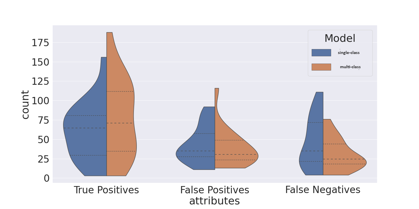
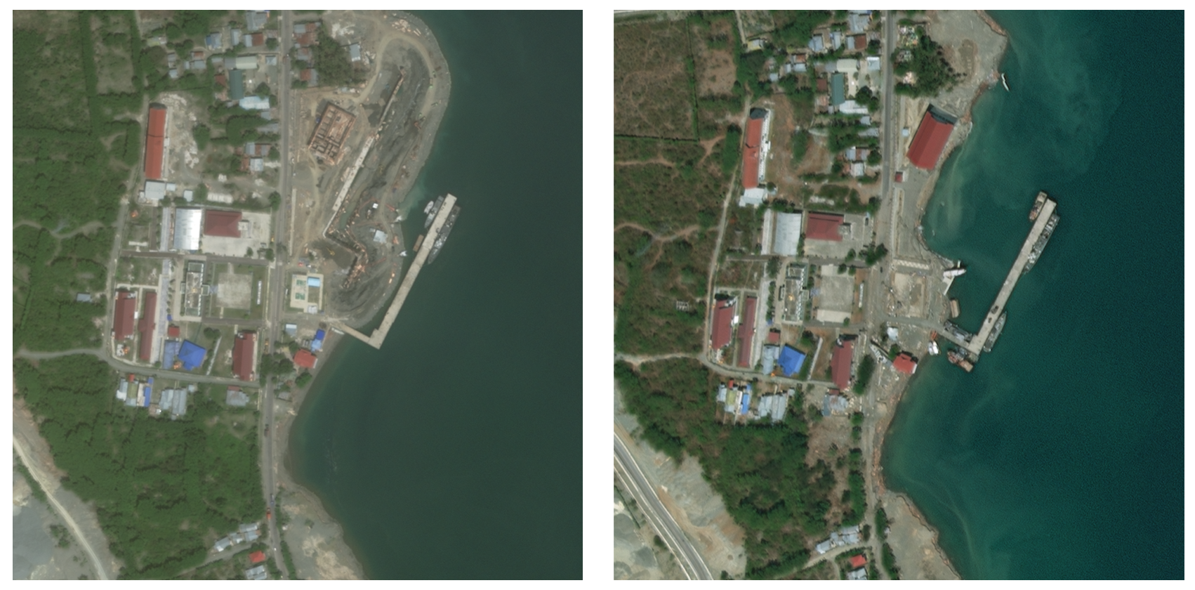
Developing countries usually lack the proper governance means to generate and regularly update a national rooftop map. Using traditional photogrammetry and surveying methods to produce a building map at the federal level is costly and time consuming. Using earth observation and deep learning methods, we can bridge this gap and propose an automated pipeline to fetch such national urban maps. This paper aims to exploit the power of fully convolutional neural networks for multi-class buildings' instance segmentation to leverage high object-wise accuracy results. Buildings' instance segmentation from sub-meter high-resolution satellite images can be achieved with relatively high pixel-wise metric scores. We detail all engineering steps to replicate this work and ensure highly accurate results in dense and slum areas witnessed in regions that lack proper urban planning in the Global South. We applied a case study of the proposed pipeline to Lebanon and successfully produced the first comprehensive national building footprint map with approximately 1 Million units with an 84% accuracy. The proposed architecture relies on advanced augmentation techniques to overcome dataset scarcity, which is often the case in developing countries.
Get summaries of the top AI research delivered straight to your inbox:
Overview
- Presents a method for automatically extracting urban maps from national-level data
- Leverages satellite imagery and deep learning models to create detailed urban maps at scale
- Aims to enable more efficient urban planning and infrastructure development
Plain English Explanation
This research paper describes a system for automatically creating detailed maps of cities and urban areas using satellite imagery and advanced machine learning techniques. The goal is to enable the creation of comprehensive national-level urban maps in a more efficient and scalable way compared to traditional manual mapping methods.
The key idea is to use deep learning models to analyze satellite imagery and automatically identify and delineate different urban features like roads, buildings, parks, and other infrastructure. By applying this approach across an entire country, the researchers were able to generate detailed urban maps covering the whole national territory.
This could be very useful for urban planners, policymakers, and infrastructure developers, as having access to up-to-date, high-resolution maps of urban areas can help with tasks like identifying areas for new development, designing more equitable transportation networks, and optimizing the placement of critical infrastructure. The automated nature of this approach also means maps can be updated more frequently to reflect changes in the urban landscape.
Technical Explanation
The researchers developed a deep learning-based pipeline to extract detailed urban maps from satellite imagery. This involved several key steps:
- Data Collection: They gathered a large dataset of high-resolution satellite imagery covering urban areas, along with corresponding ground truth maps annotated by human experts.
- Model Training: Using this data, the researchers trained a series of convolutional neural networks to recognize and delineate various urban features like roads, buildings, vegetation, and water bodies.
- Inference: Once the models were trained, they could be applied to new satellite imagery to automatically generate comprehensive urban maps, classifying each pixel into one of the target urban classes.
The models leveraged techniques like edge detection and multi-scale feature extraction to accurately identify and segment different urban elements. The researchers also explored data augmentation approaches like cut-and-paste to improve the models' generalization capabilities.
Critical Analysis
The researchers acknowledge several limitations and areas for future work:
- The models were trained on a specific set of satellite imagery, and their performance may degrade when applied to data with different characteristics (e.g., different sensors, resolutions, or environmental conditions).
- The ground truth annotations used for training were created manually, which is time-consuming and potentially subjective. Developing more scalable and consistent annotation methods could further improve the quality of the training data.
- While the automated mapping approach is more efficient than manual techniques, there may still be situations where human expert input is valuable, such as for validating the accuracy of the maps or incorporating local knowledge.
Additionally, one could question the ethical implications of such a powerful urban mapping system, particularly around issues of data privacy, surveillance, and the potential for misuse by authorities. Careful consideration of these concerns would be important as this technology is further developed and deployed.
Conclusion
This research presents an innovative approach to automatically generating detailed urban maps at a national scale using satellite imagery and deep learning. By automating a traditionally manual and labor-intensive process, the authors have demonstrated the potential to create up-to-date, comprehensive urban maps more efficiently.
These maps could have significant practical applications in areas like urban planning, infrastructure development, and emergency response. However, the researchers have also highlighted important limitations and areas for further exploration, such as improving model generalization and addressing ethical considerations around the use of such powerful mapping capabilities.
Overall, this work represents an important step forward in the field of automated urban mapping and demonstrates the transformative potential of combining satellite data and deep learning techniques to better understand and manage our cities.
This summary was produced with help from an AI and may contain inaccuracies - check out the links to read the original source documents!
Related Papers
📊
Identifying every building's function in large-scale urban areas with multi-modality remote-sensing data
Zhuohong Li, Wei He, Jiepan Li, Hongyan Zhang
0
0
Buildings, as fundamental man-made structures in urban environments, serve as crucial indicators for understanding various city function zones. Rapid urbanization has raised an urgent need for efficiently surveying building footprints and functions. In this study, we proposed a semi-supervised framework to identify every building's function in large-scale urban areas with multi-modality remote-sensing data. In detail, optical images, building height, and nighttime-light data are collected to describe the morphological attributes of buildings. Then, the area of interest (AOI) and building masks from the volunteered geographic information (VGI) data are collected to form sparsely labeled samples. Furthermore, the multi-modality data and weak labels are utilized to train a segmentation model with a semi-supervised strategy. Finally, results are evaluated by 20,000 validation points and statistical survey reports from the government. The evaluations reveal that the produced function maps achieve an OA of 82% and Kappa of 71% among 1,616,796 buildings in Shanghai, China. This study has the potential to support large-scale urban management and sustainable urban development. All collected data and produced maps are open access at https://github.com/LiZhuoHong/BuildingMap.
5/9/2024
⛏️
Terrain-Informed Self-Supervised Learning: Enhancing Building Footprint Extraction from LiDAR Data with Limited Annotations
Anuja Vats, David Volgyes, Martijn Vermeer, Marius Pedersen, Kiran Raja, Daniele S. M. Fantin, Jacob Alexander Hay
0
0
Estimating building footprint maps from geospatial data is of paramount importance in urban planning, development, disaster management, and various other applications. Deep learning methodologies have gained prominence in building segmentation maps, offering the promise of precise footprint extraction without extensive post-processing. However, these methods face challenges in generalization and label efficiency, particularly in remote sensing, where obtaining accurate labels can be both expensive and time-consuming. To address these challenges, we propose terrain-aware self-supervised learning, tailored to remote sensing, using digital elevation models from LiDAR data. We propose to learn a model to differentiate between bare Earth and superimposed structures enabling the network to implicitly learn domain-relevant features without the need for extensive pixel-level annotations. We test the effectiveness of our approach by evaluating building segmentation performance on test datasets with varying label fractions. Remarkably, with only 1% of the labels (equivalent to 25 labeled examples), our method improves over ImageNet pre-training, showing the advantage of leveraging unlabeled data for feature extraction in the domain of remote sensing. The performance improvement is more pronounced in few-shot scenarios and gradually closes the gap with ImageNet pre-training as the label fraction increases. We test on a dataset characterized by substantial distribution shifts and labeling errors to demonstrate the generalizability of our approach. When compared to other baselines, including ImageNet pretraining and more complex architectures, our approach consistently performs better, demonstrating the efficiency and effectiveness of self-supervised terrain-aware feature learning.
4/19/2024
DeepDamageNet: A two-step deep-learning model for multi-disaster building damage segmentation and classification using satellite imagery
Irene Alisjahbana (Mullet), Jiawei Li (Mullet), Ben (Mullet), Strong, Yue Zhang
0
0
Satellite imagery has played an increasingly important role in post-disaster building damage assessment. Unfortunately, current methods still rely on manual visual interpretation, which is often time-consuming and can cause very low accuracy. To address the limitations of manual interpretation, there has been a significant increase in efforts to automate the process. We present a solution that performs the two most important tasks in building damage assessment, segmentation and classification, through deep-learning models. We show our results submitted as part of the xView2 Challenge, a competition to design better models for identifying buildings and their damage level after exposure to multiple kinds of natural disasters. Our best model couples a building identification semantic segmentation convolutional neural network (CNN) to a building damage classification CNN, with a combined F1 score of 0.66, surpassing the xView2 challenge baseline F1 score of 0.28. We find that though our model was able to identify buildings with relatively high accuracy, building damage classification across various disaster types is a difficult task due to the visual similarity between different damage levels and different damage distribution between disaster types, highlighting the fact that it may be important to have a probabilistic prior estimate regarding disaster damage in order to obtain accurate predictions.
5/9/2024
⛏️
Expediting Building Footprint Extraction from High-resolution Remote Sensing Images via progressive lenient supervision
Haonan Guo, Bo Du, Chen Wu, Xin Su, Liangpei Zhang
0
0
The efficacy of building footprint segmentation from remotely sensed images has been hindered by model transfer effectiveness. Many existing building segmentation methods were developed upon the encoder-decoder architecture of U-Net, in which the encoder is finetuned from the newly developed backbone networks that are pre-trained on ImageNet. However, the heavy computational burden of the existing decoder designs hampers the successful transfer of these modern encoder networks to remote sensing tasks. Even the widely-adopted deep supervision strategy fails to mitigate these challenges due to its invalid loss in hybrid regions where foreground and background pixels are intermixed. In this paper, we conduct a comprehensive evaluation of existing decoder network designs for building footprint segmentation and propose an efficient framework denoted as BFSeg to enhance learning efficiency and effectiveness. Specifically, a densely-connected coarse-to-fine feature fusion decoder network that facilitates easy and fast feature fusion across scales is proposed. Moreover, considering the invalidity of hybrid regions in the down-sampled ground truth during the deep supervision process, we present a lenient deep supervision and distillation strategy that enables the network to learn proper knowledge from deep supervision. Building upon these advancements, we have developed a new family of building segmentation networks, which consistently surpass prior works with outstanding performance and efficiency across a wide range of newly developed encoder networks.
4/11/2024