Context-Aware Mobile Network Performance Prediction Using Network & Remote Sensing Data
2405.00220
0
0

Abstract
Accurate estimation of Network Performance is crucial for several tasks in telecom networks. Telecom networks regularly serve a vast number of radio nodes. Each radio node provides services to end-users in the associated coverage areas. The task of predicting Network Performance for telecom networks necessitates considering complex spatio-temporal interactions and incorporating geospatial information where the radio nodes are deployed. Instead of relying on historical data alone, our approach augments network historical performance datasets with satellite imagery data. Our comprehensive experiments, using real-world data collected from multiple different regions of an operational network, show that the model is robust and can generalize across different scenarios. The results indicate that the model, utilizing satellite imagery, performs very well across the tested regions. Additionally, the model demonstrates a robust approach to the cold-start problem, offering a promising alternative for initial performance estimation in newly deployed sites.
Create account to get full access
Overview
- This paper proposes a framework for predicting mobile network performance using a combination of network and remote sensing data.
- It leverages machine learning techniques to tackle the "cold-start" problem, where new geographic areas lack historical data for performance predictions.
- The approach fuses data from cellular base stations, satellite imagery, and other geospatial features to build a comprehensive model of network conditions.
- The goal is to enable more effective 5G network optimization and resource allocation by anticipating performance issues before they occur.
Plain English Explanation
In the world of mobile communication, network performance is crucial for providing a seamless and reliable experience for users. However, predicting network performance can be challenging, especially in new geographic areas where historical data is limited. This paper presents a novel framework that combines network data and remote sensing data, such as satellite imagery, to overcome this "cold-start" problem and make accurate predictions about mobile network performance.
The key idea is to leverage machine learning techniques to create a comprehensive model of network conditions, taking into account various factors like the location of cellular base stations, terrain features, and land use patterns. By fusing this diverse set of data sources, the researchers aim to better understand how the physical environment and network infrastructure interact to influence performance metrics, such as connection speed and latency.
This research on context-aware mobile network performance prediction could have significant implications for the deployment and optimization of 5G networks. By anticipating potential performance issues before they occur, network operators can proactively allocate resources and make adjustments to ensure a high-quality user experience, even in areas with limited historical data.
Technical Explanation
The proposed framework leverages a combination of network data and remote sensing data to predict mobile network performance. The network data includes information from cellular base stations, such as signal strength, throughput, and latency. The remote sensing data includes satellite imagery and other geospatial features, such as terrain elevation, land cover, and population density.
The researchers use machine learning techniques, such as spatial-temporal forecasting and handover prediction, to build a model that can predict key performance indicators (KPIs) for mobile networks. The model is designed to work in "cold-start" scenarios, where new geographic areas lack historical data for performance predictions.
The approach involves several key steps:
- Data collection and preprocessing: The researchers gather and clean the network and remote sensing data, aligning the various data sources spatially and temporally.
- Feature engineering: They extract relevant features from the data, such as terrain characteristics, land use patterns, and network infrastructure details.
- Model training and validation: The researchers train and validate their machine learning models using the prepared data, evaluating their performance on various KPIs.
- Deployment and inference: The trained models can then be used to predict network performance in new geographic areas, enabling proactive network optimization and resource allocation.
The findings from this research could help network operators more effectively plan and deploy 5G networks, addressing performance challenges before they impact end-users.
Critical Analysis
The proposed framework presents a promising approach to tackling the "cold-start" problem in mobile network performance prediction. By integrating network data and remote sensing data, the researchers aim to create a more comprehensive understanding of the factors influencing network performance.
One potential limitation of the study is the reliance on satellite imagery as the primary source of remote sensing data. While satellite imagery can provide valuable information about the physical environment, it may not capture all the relevant factors that can impact network performance, such as indoor building characteristics or user density. Incorporating additional data sources, such as ground-level imagery or crowd-sourced data, could further improve the model's predictive capabilities.
Additionally, the paper does not provide a detailed analysis of the model's performance in real-world deployment scenarios. It would be valuable to understand how the framework performs in terms of accuracy, reliability, and computational efficiency when applied to large-scale networks with complex, heterogeneous environments.
Overall, this research represents an important step towards more effective 5G network optimization and resource allocation. By leveraging the power of machine learning and multi-modal data fusion, the proposed framework has the potential to enhance the user experience and support the ongoing deployment of advanced mobile communication technologies.
Conclusion
This paper presents a novel framework for predicting mobile network performance using a combination of network data and remote sensing data. By fusing these diverse data sources and applying machine learning techniques, the researchers aim to overcome the "cold-start" problem and enable more effective 5G network optimization.
The key contribution of this work is the integration of satellite imagery and other geospatial features with traditional network metrics to build a comprehensive model of network conditions. This approach could help network operators anticipate performance issues before they impact end-users, allowing for proactive resource allocation and network adjustments.
While the study demonstrates promising results, further research is needed to explore the framework's real-world performance and adaptability to different environments. Nonetheless, this research represents an important step towards unlocking the full potential of 5G networks and enhancing the overall mobile user experience.
This summary was produced with help from an AI and may contain inaccuracies - check out the links to read the original source documents!
Related Papers
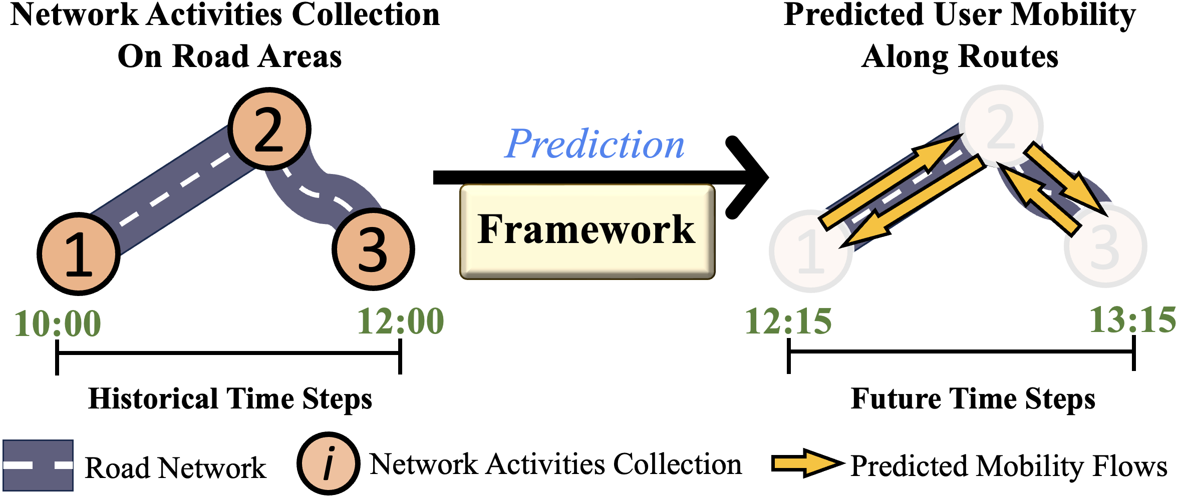
Enhancing Sustainable Urban Mobility Prediction with Telecom Data: A Spatio-Temporal Framework Approach
ChungYi Lin, Shen-Lung Tung, Hung-Ting Su, Winston H. Hsu
0
0
Traditional traffic prediction, limited by the scope of sensor data, falls short in comprehensive traffic management. Mobile networks offer a promising alternative using network activity counts, but these lack crucial directionality. Thus, we present the TeltoMob dataset, featuring undirected telecom counts and corresponding directional flows, to predict directional mobility flows on roadways. To address this, we propose a two-stage spatio-temporal graph neural network (STGNN) framework. The first stage uses a pre-trained STGNN to process telecom data, while the second stage integrates directional and geographic insights for accurate prediction. Our experiments demonstrate the framework's compatibility with various STGNN models and confirm its effectiveness. We also show how to incorporate the framework into real-world transportation systems, enhancing sustainable urban mobility.
5/29/2024

SATSense: Multi-Satellite Collaborative Framework for Spectrum Sensing
Haoxuan Yuan, Zhe Chen, Zheng Lin, Jinbo Peng, Zihan Fang, Yuhang Zhong, Zihang Song, Yue Gao
0
0
Low Earth Orbit satellite Internet has recently been deployed, providing worldwide service with non-terrestrial networks. With the large-scale deployment of both non-terrestrial and terrestrial networks, limited spectrum resources will not be allocated enough. Consequently, dynamic spectrum sharing is crucial for their coexistence in the same spectrum, where accurate spectrum sensing is essential. However, spectrum sensing in space is more challenging than in terrestrial networks due to variable channel conditions, making single-satellite sensing unstable. Therefore, we first attempt to design a collaborative sensing scheme utilizing diverse data from multiple satellites. However, it is non-trivial to achieve this collaboration due to heterogeneous channel quality, considerable raw sampling data, and packet loss. To address the above challenges, we first establish connections between the satellites by modeling their sensing data as a graph and devising a graph neural network-based algorithm to achieve effective spectrum sensing. Meanwhile, we establish a joint sub-Nyquist sampling and autoencoder data compression framework to reduce the amount of transmitted sensing data. Finally, we propose a contrastive learning-based mechanism compensates for missing packets. Extensive experiments demonstrate that our proposed strategy can achieve efficient spectrum sensing performance and outperform the conventional deep learning algorithm in spectrum sensing accuracy.
5/27/2024

Spatial Models for Crowdsourced Internet Access Network Performance Measurements
Taveesh Sharma, Paul Schmitt, Francesco Bronzino, Nick Feamster, Nicole Marwell
0
0
Despite significant investments in access network infrastructure, universal access to high-quality Internet connectivity remains a challenge. Policymakers often rely on large-scale, crowdsourced measurement datasets to assess the distribution of access network performance across geographic areas. These decisions typically rest on the assumption that Internet performance is uniformly distributed within predefined social boundaries, such as zip codes, census tracts, or community areas. However, this assumption may not be valid for two reasons: (1) crowdsourced measurements often exhibit non-uniform sampling densities within geographic areas; and (2) predefined social boundaries may not align with the actual boundaries of Internet infrastructure. In this paper, we model Internet performance as a spatial process. We apply and evaluate a series of statistical techniques to: (1) aggregate Internet performance over a geographic region; (2) overlay interpolated maps with various sampling boundary choices; and (3) spatially cluster boundary units to identify areas with similar performance characteristics. We evaluated the effectiveness of these using a 17-month-long crowdsourced dataset from Ookla Speedtest. We evaluate several leading interpolation methods at varying spatial scales. Further, we examine the similarity between the resulting boundaries for smaller realizations of the dataset. Our findings suggest that our combination of techniques achieves a 56% gain in similarity score over traditional methods that rely on aggregates over raw measurement values for performance summarization. Our work highlights an urgent need for more sophisticated strategies in understanding and addressing Internet access disparities.
5/22/2024
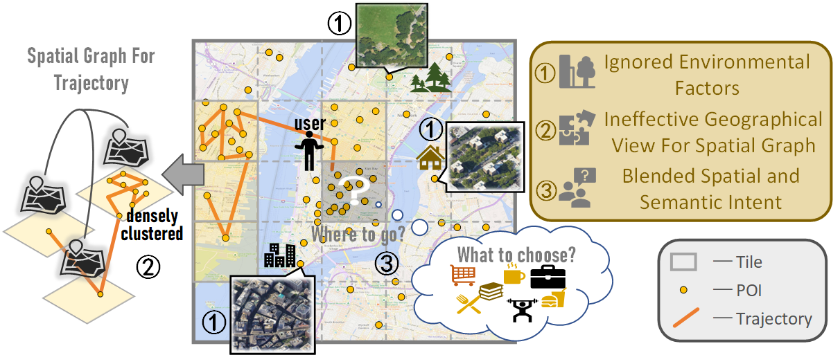
Towards Effective Next POI Prediction: Spatial and Semantic Augmentation with Remote Sensing Data
Nan Jiang, Haitao Yuan, Jianing Si, Minxiao Chen, Shangguang Wang
0
0
The next point-of-interest (POI) prediction is a significant task in location-based services, yet its complexity arises from the consolidation of spatial and semantic intent. This fusion is subject to the influences of historical preferences, prevailing location, and environmental factors, thereby posing significant challenges. In addition, the uneven POI distribution further complicates the next POI prediction procedure. To address these challenges, we enrich input features and propose an effective deep-learning method within a two-step prediction framework. Our method first incorporates remote sensing data, capturing pivotal environmental context to enhance input features regarding both location and semantics. Subsequently, we employ a region quad-tree structure to integrate urban remote sensing, road network, and POI distribution spaces, aiming to devise a more coherent graph representation method for urban spatial. Leveraging this method, we construct the QR-P graph for the user's historical trajectories to encapsulate historical travel knowledge, thereby augmenting input features with comprehensive spatial and semantic insights. We devise distinct embedding modules to encode these features and employ an attention mechanism to fuse diverse encodings. In the two-step prediction procedure, we initially identify potential spatial zones by predicting user-preferred tiles, followed by pinpointing specific POIs of a designated type within the projected tiles. Empirical findings from four real-world location-based social network datasets underscore the remarkable superiority of our proposed approach over competitive baseline methods.
4/9/2024