Continuous Monitoring for Road Flooding With Satellite Onboard Computing For Navigation for OrbitalAI {Phi}sat-2 challenge

0
⚙️
Sign in to get full access
Overview
- The paper explores the feasibility of using onboard computing of satellite imagery to detect road flooding in near real-time and provide dynamic information for navigation maps.
- It describes the development of a simulated onboard imagery dataset and its annotation process for the OrbitalAI {Phi}sat-2 challenge, focusing on flooding events in Bengaluru, India.
- The paper presents the model architecture selection, training, optimization, and accuracy results for this road flooding detection use case.
- The key finding is that it is possible to build low-size, high-accuracy models for real-time monitoring of road flooding using satellite data.
Plain English Explanation
The paper looks at a way to use satellite images to quickly detect when roads are flooded. This could be done by having computers on the satellites analyze the images as they are taken, rather than sending the images back to Earth first. This could provide near real-time updates on flooding for navigation apps and maps.
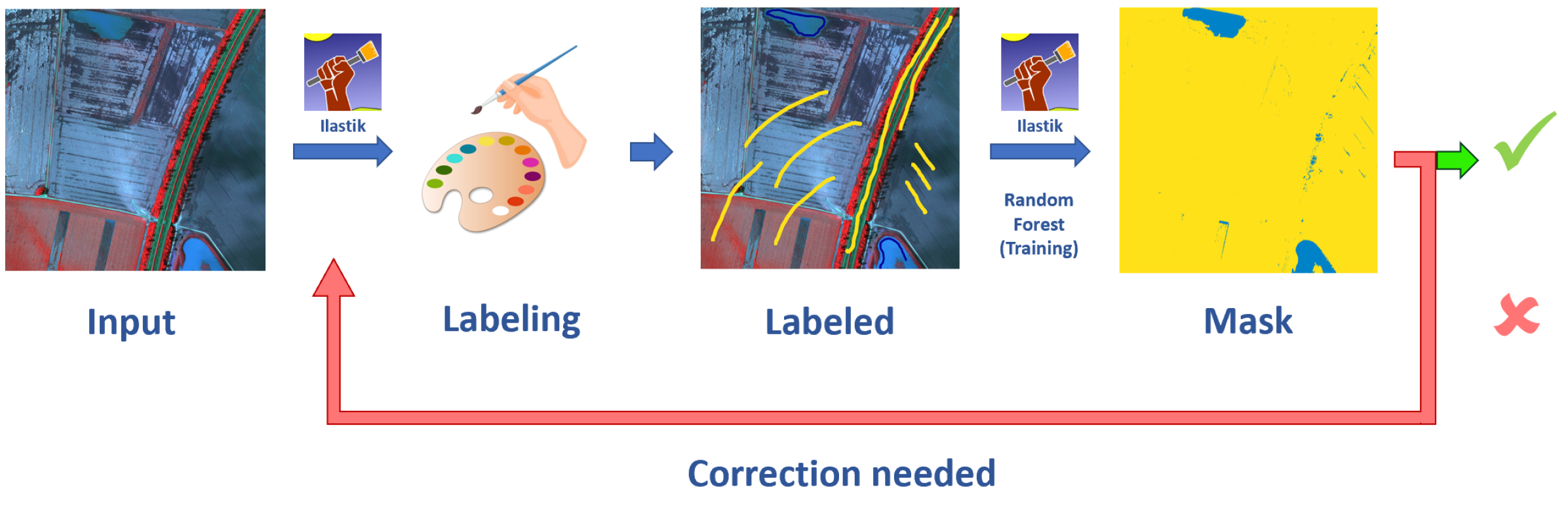
The researchers created a simulated dataset of satellite images showing flooding in Bengaluru, India. They then used this dataset to train and optimize a machine learning model to detect road floods from the satellite images. The process of developing and annotating this dataset is similar to the approaches used in the SpaceNet 8 challenge.
The results show that it is possible to build small, accurate models that can run on the computers inside satellites to detect road flooding. This could allow for real-time flood monitoring and updates to navigation systems, without needing to send all the satellite images back to Earth first. The ability to process data on the satellites themselves, rather than centrally, is an active area of research in remote sensing and edge computing.
Technical Explanation
The paper explores the feasibility of using onboard computing of satellite imagery to detect road flooding in near real-time. It describes the development of a simulated onboard imagery dataset and its annotation process for the OrbitalAI {Phi}sat-2 challenge, focusing on flooding events in Bengaluru, India.
The researchers created a dataset of simulated satellite imagery showing road flooding in Bengaluru. They then annotated this dataset to label the flooded areas. This process of creating and annotating remote sensing data for machine learning models is an active area of research.
The paper then presents the model architecture selection, training, and optimization process for this road flooding detection use case. The results indicate that it is possible to build low-size, high-accuracy models that can run on the computing hardware available on satellites, like that used for the PhiSat-2 mission. This aligns with broader research on processing sensor data at the edge, rather than in a centralized location.
Critical Analysis
The paper provides a promising proof-of-concept for using onboard satellite computing to enable near real-time road flood monitoring. However, the research is limited to a simulated dataset and a specific geographic region. Further testing and validation would be needed to ensure the approach works reliably in diverse real-world conditions.
Additionally, integrating this type of flood detection system with dynamic mapping and navigation applications would require additional research and development. Challenges around data latency, coverage, and integration with existing systems would need to be addressed.
While the paper demonstrates the technical feasibility, more work is needed to understand the operational, business, and policy implications of deploying such a system at scale. Automated mapping of urban features from satellite imagery is an active area of research with wider applications.
Conclusion
This paper presents an innovative approach to leveraging onboard satellite computing for near real-time road flood monitoring. By performing the image analysis directly on the satellite, rather than transmitting all the data back to Earth, the system could provide dynamic flood information to navigation apps and maps much faster.
The researchers have shown the feasibility of building small, accurate machine learning models capable of running on existing satellite hardware. This is an important step towards enabling satellite-based flood monitoring systems that can deliver timely, actionable insights to support disaster response and transportation planning.
This summary was produced with help from an AI and may contain inaccuracies - check out the links to read the original source documents!
Related Papers
⚙️
0
Continuous Monitoring for Road Flooding With Satellite Onboard Computing For Navigation for OrbitalAI {Phi}sat-2 challenge
Vishesh Vatsal, Gouranga Nandi, Primo Manilal
Continuous monitoring for road flooding could be achieved through onboard computing of satellite imagery to generate near real-time insights made available to generate dynamic information for maps used for navigation. Given the existing computing hardware like the one considered for the PhiSat-2 mission, the paper describes the feasibility of running the road flooding detection. The simulated onboard imagery dataset development and its annotation process for the OrbitalAI {Phi}sat-2 challenge is described. The flooding events in the city of Bengaluru, India were considered for this challenge. This is followed by the model architecture selection, training, optimization and accuracy results for the model. The results indicate that it is possible to build low size, high accuracy models for the road flooding use case.
Read more5/7/2024
🤖
0
AI techniques for near real-time monitoring of contaminants in coastal waters on board future Phisat-2 mission
Francesca Razzano, Pietro Di Stasio, Francesco Mauro, Gabriele Meoni, Marco Esposito, Gilda Schirinzi, Silvia L. Ullo
Differently from conventional procedures, the proposed solution advocates for a groundbreaking paradigm in water quality monitoring through the integration of satellite Remote Sensing (RS) data, Artificial Intelligence (AI) techniques, and onboard processing. The objective is to offer nearly real-time detection of contaminants in coastal waters addressing a significant gap in the existing literature. Moreover, the expected outcomes include substantial advancements in environmental monitoring, public health protection, and resource conservation. The specific focus of our study is on the estimation of Turbidity and pH parameters, for their implications on human and aquatic health. Nevertheless, the designed framework can be extended to include other parameters of interest in the water environment and beyond. Originating from our participation in the European Space Agency (ESA) OrbitalAI Challenge, this article describes the distinctive opportunities and issues for the contaminants monitoring on the Phisat-2 mission. The specific characteristics of this mission, with the tools made available, will be presented, with the methodology proposed by the authors for the onboard monitoring of water contaminants in near real-time. Preliminary promising results are discussed and in progress and future work introduced.
Read more5/1/2024
📊
0
Flood Data Analysis on SpaceNet 8 Using Apache Sedona
Yanbing Bai, Zihao Yang, Jinze Yu, Rui-Yang Ju, Bin Yang, Erick Mas, Shunichi Koshimura
With the escalating frequency of floods posing persistent threats to human life and property, satellite remote sensing has emerged as an indispensable tool for monitoring flood hazards. SpaceNet8 offers a unique opportunity to leverage cutting-edge artificial intelligence technologies to assess these hazards. A significant contribution of this research is its application of Apache Sedona, an advanced platform specifically designed for the efficient and distributed processing of large-scale geospatial data. This platform aims to enhance the efficiency of error analysis, a critical aspect of improving flood damage detection accuracy. Based on Apache Sedona, we introduce a novel approach that addresses the challenges associated with inaccuracies in flood damage detection. This approach involves the retrieval of cases from historical flood events, the adaptation of these cases to current scenarios, and the revision of the model based on clustering algorithms to refine its performance. Through the replication of both the SpaceNet8 baseline and its top-performing models, we embark on a comprehensive error analysis. This analysis reveals several main sources of inaccuracies. To address these issues, we employ data visual interpretation and histogram equalization techniques, resulting in significant improvements in model metrics. After these enhancements, our indicators show a notable improvement, with precision up by 5%, F1 score by 2.6%, and IoU by 4.5%. This work highlights the importance of advanced geospatial data processing tools, such as Apache Sedona. By improving the accuracy and efficiency of flood detection, this research contributes to safeguarding public safety and strengthening infrastructure resilience in flood-prone areas, making it a valuable addition to the field of remote sensing and disaster management.
Read more4/30/2024
0
BlessemFlood21: Advancing Flood Analysis with a High-Resolution Georeferenced Dataset for Humanitarian Aid Support
Vladyslav Polushko, Alexander Jenal, Jens Bongartz, Immanuel Weber, Damjan Hatic, Ronald Rosch, Thomas Marz, Markus Rauhut, Andreas Weinmann
Floods are an increasingly common global threat, causing emergencies and severe damage to infrastructure. During crises, organisations such as the World Food Programme use remotely sensed imagery, typically obtained through drones, for rapid situational analysis to plan life-saving actions. Computer Vision tools are needed to support task force experts on-site in the evaluation of the imagery to improve their efficiency and to allocate resources strategically. We introduce the BlessemFlood21 dataset to stimulate research on efficient flood detection tools. The imagery was acquired during the 2021 Erftstadt-Blessem flooding event and consists of high-resolution and georeferenced RGB-NIR images. In the resulting RGB dataset, the images are supplemented with detailed water masks, obtained via a semi-supervised human-in-the-loop technique, where in particular the NIR information is leveraged to classify pixels as either water or non-water. We evaluate our dataset by training and testing established Deep Learning models for semantic segmentation. With BlessemFlood21 we provide labeled high-resolution RGB data and a baseline for further development of algorithmic solutions tailored to flood detection in RGB imagery.
Read more7/9/2024