Data Augmentation in Earth Observation: A Diffusion Model Approach
2406.06218
0
0

Abstract
The scarcity of high-quality Earth Observation (EO) imagery poses a significant challenge, despite its critical role in enabling precise analysis and informed decision-making across various sectors. This scarcity is primarily due to atmospheric conditions, seasonal variations, and limited geographical coverage, which complicates the application of Artificial Intelligence (AI) in EO. Data augmentation, a widely used technique in AI that involves generating additional data mainly through parameterized image transformations, has been employed to increase the volume and diversity of data. However, this method often falls short in generating sufficient diversity across key semantic axes, adversely affecting the accuracy of EO applications. To address this issue, we propose a novel four-stage approach aimed at improving the diversity of augmented data by integrating diffusion models. Our approach employs meta-prompts for instruction generation, harnesses general-purpose vision-language models for generating rich captions, fine-tunes an Earth Observation diffusion model, and iteratively augments data. We conducted extensive experiments using four different data augmentation techniques, and our approach consistently demonstrated improvements, outperforming the established augmentation methods, revealing its effectiveness in generating semantically rich and diverse EO images.
Create account to get full access
Overview
- Presents a novel approach to data augmentation for Earth observation imagery using diffusion models
- Demonstrates the ability of diffusion models to generate realistic synthetic satellite images that can be used to improve deep learning model performance
- Explores the impact of diffusion-based data augmentation on various Earth observation tasks, including classification, change detection, and object detection
Plain English Explanation
Satellite and aerial imagery is crucial for many important applications, such as monitoring land use, tracking climate change, and assisting disaster response efforts. However, obtaining large, diverse datasets of high-quality Earth observation data can be challenging and expensive. This research explores using diffusion models as a way to generate new, synthetic satellite images that can be used to expand and diversify the available data.
Diffusion models are a type of generative AI model that can create new images by gradually adding noise to an input image and then learning to reverse the process to generate realistic-looking outputs. The researchers show that these models can be trained on existing satellite imagery to learn the underlying patterns and structures, and then used to produce new, plausible-looking satellite images that can be used to augment the training data for deep learning models.
By testing this approach on a variety of Earth observation tasks, the researchers demonstrate that diffusion-based data augmentation can significantly improve the performance of deep learning models, especially when the original training data is limited. This could be particularly useful for addressing the challenges of missing or noisy data in model predictions or for detecting out-of-distribution samples that the models have not been exposed to during training.
Technical Explanation
The researchers propose a data augmentation approach for Earth observation imagery using diffusion models. Diffusion models are a type of generative AI model that can create new images by gradually adding noise to an input image and then learning to reverse the process to generate realistic-looking outputs.
The researchers first train a diffusion model on a dataset of existing satellite and aerial imagery. This allows the model to learn the underlying patterns and structures present in Earth observation data, which it can then use to generate new, synthetic images that share these characteristics.
To assess the effectiveness of this approach, the researchers evaluate the performance of deep learning models trained on a combination of real and diffusion-generated synthetic images across a range of Earth observation tasks, including classification, change detection, and object detection. They compare the results to models trained on the real data alone, as well as models augmented with other common data augmentation techniques, such as flipping, rotating, or adding noise to the original images.
The results show that the diffusion-based data augmentation approach consistently outperforms the other methods, leading to significant improvements in model performance, especially when the original training data is limited. The researchers attribute this to the ability of diffusion models to generate diverse, realistic-looking synthetic images that closely match the statistical properties of the real Earth observation data.
Critical Analysis
The researchers provide a thorough and well-designed study that demonstrates the potential of diffusion models for data augmentation in the Earth observation domain. However, the paper does acknowledge several caveats and limitations that should be considered:
- The experiments were conducted on a relatively small set of benchmark datasets, and the researchers note that further validation on larger, more diverse datasets would be valuable to assess the generalizability of the findings.
- The diffusion model architecture and hyperparameters were not extensively tuned, and it's possible that further improvements could be made by optimizing these aspects of the model.
- The paper does not address the computational and resource requirements of training and deploying the diffusion models, which could be a practical concern for some applications.
- While the generated synthetic images appear realistic, the researchers do not provide a detailed analysis of the fidelity and realism of the images compared to the real data.
Additionally, one could argue that the paper focuses primarily on demonstrating the technical feasibility and performance improvements of the diffusion-based approach, without delving deeply into the broader implications or potential societal impacts of this technology. Further research could explore these aspects, such as the ethical considerations around the use of synthetic data, the potential for misuse or unintended consequences, and the long-term sustainability of this approach in the rapidly evolving field of Earth observation.
Conclusion
This research presents a novel approach to data augmentation for Earth observation imagery using diffusion models. The results show that this technique can significantly improve the performance of deep learning models across a variety of tasks, particularly when the original training data is limited. This could have important implications for addressing challenges in areas like missing data, out-of-distribution detection, and generative foundation models for satellite and aerial imagery.
While the paper demonstrates the technical feasibility of this approach, further research is needed to fully explore the practical considerations, potential limitations, and broader implications of using diffusion-based data augmentation in real-world Earth observation applications. Nevertheless, this work represents an important step forward in leveraging advanced generative AI techniques to enhance the capabilities of deep learning models in this critical domain.
This summary was produced with help from an AI and may contain inaccuracies - check out the links to read the original source documents!
Related Papers

Detecting Out-Of-Distribution Earth Observation Images with Diffusion Models
Georges Le Bellier (CEDRIC - VERTIGO, CNAM), Nicolas Audebert (CEDRIC - VERTIGO, CNAM, IGN)
0
0
Earth Observation imagery can capture rare and unusual events, such as disasters and major landscape changes, whose visual appearance contrasts with the usual observations. Deep models trained on common remote sensing data will output drastically different features for these out-of-distribution samples, compared to those closer to their training dataset. Detecting them could therefore help anticipate changes in the observations, either geographical or environmental. In this work, we show that the reconstruction error of diffusion models can effectively serve as unsupervised out-of-distribution detectors for remote sensing images, using them as a plausibility score. Moreover, we introduce ODEED, a novel reconstruction-based scorer using the probability-flow ODE of diffusion models. We validate it experimentally on SpaceNet 8 with various scenarios, such as classical OOD detection with geographical shift and near-OOD setups: pre/post-flood and non-flooded/flooded image recognition. We show that our ODEED scorer significantly outperforms other diffusion-based and discriminative baselines on the more challenging near-OOD scenarios of flood image detection, where OOD images are close to the distribution tail. We aim to pave the way towards better use of generative models for anomaly detection in remote sensing.
4/22/2024

Impact Assessment of Missing Data in Model Predictions for Earth Observation Applications
Francisco Mena, Diego Arenas, Marcela Charfuelan, Marlon Nuske, Andreas Dengel
0
0
Earth observation (EO) applications involving complex and heterogeneous data sources are commonly approached with machine learning models. However, there is a common assumption that data sources will be persistently available. Different situations could affect the availability of EO sources, like noise, clouds, or satellite mission failures. In this work, we assess the impact of missing temporal and static EO sources in trained models across four datasets with classification and regression tasks. We compare the predictive quality of different methods and find that some are naturally more robust to missing data. The Ensemble strategy, in particular, achieves a prediction robustness up to 100%. We evidence that missing scenarios are significantly more challenging in regression than classification tasks. Finally, we find that the optical view is the most critical view when it is missing individually.
5/14/2024
DiffusionSat: A Generative Foundation Model for Satellite Imagery
Samar Khanna, Patrick Liu, Linqi Zhou, Chenlin Meng, Robin Rombach, Marshall Burke, David Lobell, Stefano Ermon
0
0
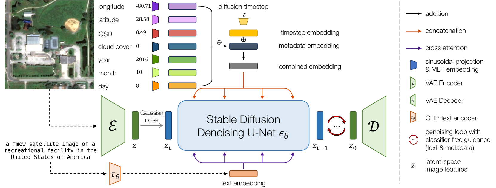
Diffusion models have achieved state-of-the-art results on many modalities including images, speech, and video. However, existing models are not tailored to support remote sensing data, which is widely used in important applications including environmental monitoring and crop-yield prediction. Satellite images are significantly different from natural images -- they can be multi-spectral, irregularly sampled across time -- and existing diffusion models trained on images from the Web do not support them. Furthermore, remote sensing data is inherently spatio-temporal, requiring conditional generation tasks not supported by traditional methods based on captions or images. In this paper, we present DiffusionSat, to date the largest generative foundation model trained on a collection of publicly available large, high-resolution remote sensing datasets. As text-based captions are sparsely available for satellite images, we incorporate the associated metadata such as geolocation as conditioning information. Our method produces realistic samples and can be used to solve multiple generative tasks including temporal generation, superresolution given multi-spectral inputs and in-painting. Our method outperforms previous state-of-the-art methods for satellite image generation and is the first large-scale generative foundation model for satellite imagery. The project website can be found here: https://samar-khanna.github.io/DiffusionSat/
5/28/2024

A Comprehensive Survey on Data Augmentation
Zaitian Wang, Pengfei Wang, Kunpeng Liu, Pengyang Wang, Yanjie Fu, Chang-Tien Lu, Charu C. Aggarwal, Jian Pei, Yuanchun Zhou
0
0
Data augmentation is a series of techniques that generate high-quality artificial data by manipulating existing data samples. By leveraging data augmentation techniques, AI models can achieve significantly improved applicability in tasks involving scarce or imbalanced datasets, thereby substantially enhancing AI models' generalization capabilities. Existing literature surveys only focus on a certain type of specific modality data, and categorize these methods from modality-specific and operation-centric perspectives, which lacks a consistent summary of data augmentation methods across multiple modalities and limits the comprehension of how existing data samples serve the data augmentation process. To bridge this gap, we propose a more enlightening taxonomy that encompasses data augmentation techniques for different common data modalities. Specifically, from a data-centric perspective, this survey proposes a modality-independent taxonomy by investigating how to take advantage of the intrinsic relationship between data samples, including single-wise, pair-wise, and population-wise sample data augmentation methods. Additionally, we categorize data augmentation methods across five data modalities through a unified inductive approach.
5/20/2024