A Fast Dynamic Point Detection Method for LiDAR-Inertial Odometry in Driving Scenarios

0

Sign in to get full access
Overview
- This paper proposes a fast dynamic point detection method for LiDAR-inertial odometry in driving scenarios.
- The method aims to efficiently identify dynamic points in the LiDAR point cloud, which is crucial for robust localization and mapping.
- The authors develop a novel point-wise dynamic feature learning approach and a fast dynamic point detection algorithm.
Plain English Explanation
The paper focuses on the challenge of accurately tracking a vehicle's position and orientation (known as localization) using data from LiDAR sensors and inertial measurement units (IMUs) in dynamic driving environments. <a href="https://aimodels.fyi/papers/arxiv/lidar-based-real-time-object-detection-tracking">LiDAR sensors</a> provide a detailed 3D map of the surroundings, while IMUs measure the vehicle's movement.
In driving scenarios, there are often dynamic objects like other vehicles, pedestrians, or animals that can confuse the localization algorithms. The key insight of this paper is that by quickly identifying which points in the LiDAR data correspond to dynamic objects, the localization can be made more robust and accurate.
The authors develop a novel machine learning approach to learn the distinctive features of dynamic points in the LiDAR data. This allows them to build a fast algorithm that can efficiently separate the static background from the dynamic foreground. By removing the dynamic points, the localization can focus on the reliable static environment.
Technical Explanation
The paper introduces a point-wise dynamic feature learning approach to identify dynamic points in the LiDAR point cloud. This involves training a neural network to recognize the subtle differences between static and dynamic points based on local geometric and appearance features.
The authors also propose a fast dynamic point detection algorithm that applies this trained model to quickly classify each point as static or dynamic. This avoids the need for computationally expensive motion segmentation techniques.
The proposed method is evaluated on several driving datasets and shown to outperform existing dynamic point removal approaches in terms of both accuracy and efficiency. The authors demonstrate that using their dynamic point detection improves the performance of a LiDAR-inertial odometry system, particularly in challenging dynamic environments.
Critical Analysis
The paper makes a valuable contribution by addressing a key challenge in LiDAR-based localization and SLAM (simultaneous localization and mapping) systems. Identifying dynamic objects is crucial for maintaining an accurate map of the static environment, which is the foundation for robust vehicle pose estimation.
However, the authors acknowledge that their method may struggle with poorly illuminated or occluded objects, as the appearance and geometric features used for classification can be unreliable in such cases. Further research is needed to make the dynamic point detection more robust to varied environmental conditions.
Additionally, the paper does not provide a detailed analysis of the computational complexity or runtime performance of the proposed algorithm. While the authors claim it is "fast", more quantitative comparisons to alternative approaches would help readers assess its practical feasibility for real-time applications.
Conclusion
This paper presents an efficient solution for identifying dynamic points in LiDAR data, a critical step for improving the reliability of LiDAR-inertial odometry systems in autonomous driving scenarios. By leveraging machine learning to learn distinctive dynamic features, the authors develop a fast algorithm that can enhance localization and mapping performance, particularly in cluttered environments with many moving objects.
The research demonstrates the value of combining advanced sensor fusion techniques with intelligent data processing to overcome the challenges of real-world autonomous navigation. As self-driving technology continues to evolve, innovations like this dynamic point detection method will play an important role in making these systems more robust and reliable.
This summary was produced with help from an AI and may contain inaccuracies - check out the links to read the original source documents!
Related Papers
0
A Fast Dynamic Point Detection Method for LiDAR-Inertial Odometry in Driving Scenarios
Zikang Yuan, Xiaoxiang Wang, Jingying Wu, Junda Cheng, Xin Yang
Existing 3D point-based dynamic point detection and removal methods have a significant time overhead, making them difficult to adapt to LiDAR-inertial odometry systems. This paper proposes a label consistency based dynamic point detection and removal method for handling moving vehicles and pedestrians in autonomous driving scenarios, and embeds the proposed dynamic point detection and removal method into a self-designed LiDAR-inertial odometry system. Experimental results on three public datasets demonstrate that our method can accomplish the dynamic point detection and removal with extremely low computational overhead (i.e., 1$sim$9ms) in LIO systems, meanwhile achieve comparable preservation rate and rejection rate to state-of-the-art methods and significantly enhance the accuracy of pose estimation. We have released the source code of this work for the development of the community.
Read more7/8/2024

0
LiDAR-based Real-Time Object Detection and Tracking in Dynamic Environments
Wenqiang Du, Giovanni Beltrame
In dynamic environments, the ability to detect and track moving objects in real-time is crucial for autonomous robots to navigate safely and effectively. Traditional methods for dynamic object detection rely on high accuracy odometry and maps to detect and track moving objects. However, these methods are not suitable for long-term operation in dynamic environments where the surrounding environment is constantly changing. In order to solve this problem, we propose a novel system for detecting and tracking dynamic objects in real-time using only LiDAR data. By emphasizing the extraction of low-frequency components from LiDAR data as feature points for foreground objects, our method significantly reduces the time required for object clustering and movement analysis. Additionally, we have developed a tracking approach that employs intensity-based ego-motion estimation along with a sliding window technique to assess object movements. This enables the precise identification of moving objects and enhances the system's resilience to odometry drift. Our experiments show that this system can detect and track dynamic objects in real-time with an average detection accuracy of 88.7% and a recall rate of 89.1%. Furthermore, our system demonstrates resilience against the prolonged drift typically associated with front-end only LiDAR odometry. All of the source code, labeled dataset, and the annotation tool are available at: https://github.com/MISTLab/lidar_dynamic_objects_detection.git
Read more7/8/2024

0
Observation Time Difference: an Online Dynamic Objects Removal Method for Ground Vehicles
Rongguang Wu, Chenglin Pang, Xuankang Wu, Zheng Fang
In the process of urban environment mapping, the sequential accumulations of dynamic objects will leave a large number of traces in the map. These traces will usually have bad influences on the localization accuracy and navigation performance of the robot. Therefore, dynamic objects removal plays an important role for creating clean map. However, conventional dynamic objects removal methods usually run offline. That is, the map is reprocessed after it is constructed, which undoubtedly increases additional time costs. To tackle the problem, this paper proposes a novel method for online dynamic objects removal for ground vehicles. According to the observation time difference between the object and the ground where it is located, dynamic objects are classified into two types: suddenly appear and suddenly disappear. For these two kinds of dynamic objects, we propose downward retrieval and upward retrieval methods to eliminate them respectively. We validate our method on SemanticKITTI dataset and author-collected dataset with highly dynamic objects. Compared with other state-of-the-art methods, our method is more efficient and robust, and reduces the running time per frame by more than 60$%$ on average.
Read more6/26/2024
0
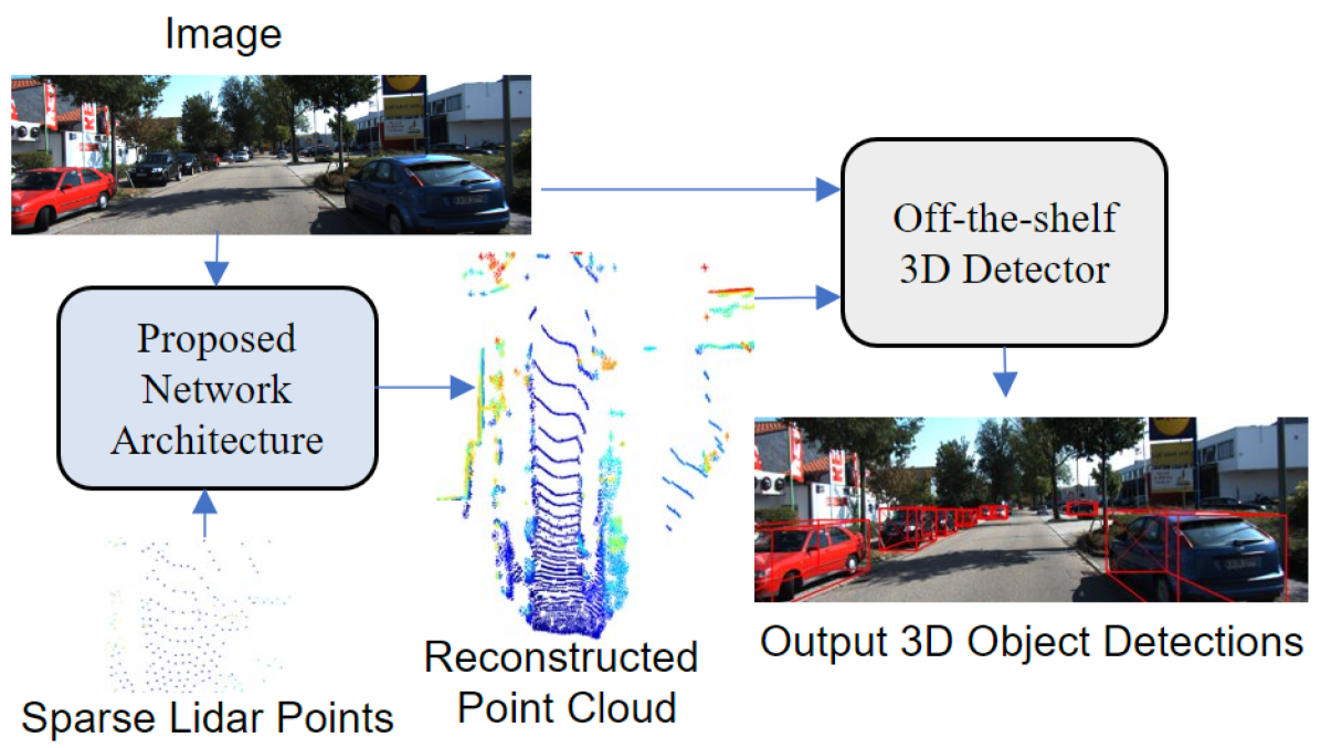
Sparse Points to Dense Clouds: Enhancing 3D Detection with Limited LiDAR Data
Aakash Kumar, Chen Chen, Ajmal Mian, Neils Lobo, Mubarak Shah
3D detection is a critical task that enables machines to identify and locate objects in three-dimensional space. It has a broad range of applications in several fields, including autonomous driving, robotics and augmented reality. Monocular 3D detection is attractive as it requires only a single camera, however, it lacks the accuracy and robustness required for real world applications. High resolution LiDAR on the other hand, can be expensive and lead to interference problems in heavy traffic given their active transmissions. We propose a balanced approach that combines the advantages of monocular and point cloud-based 3D detection. Our method requires only a small number of 3D points, that can be obtained from a low-cost, low-resolution sensor. Specifically, we use only 512 points, which is just 1% of a full LiDAR frame in the KITTI dataset. Our method reconstructs a complete 3D point cloud from this limited 3D information combined with a single image. The reconstructed 3D point cloud and corresponding image can be used by any multi-modal off-the-shelf detector for 3D object detection. By using the proposed network architecture with an off-the-shelf multi-modal 3D detector, the accuracy of 3D detection improves by 20% compared to the state-of-the-art monocular detection methods and 6% to 9% compare to the baseline multi-modal methods on KITTI and JackRabbot datasets.
Read more4/11/2024