An Open-Source Tool for Mapping War Destruction at Scale in Ukraine using Sentinel-1 Time Series

0

Sign in to get full access
Overview
- This paper presents an open-source tool for mapping war destruction at scale in Ukraine using Sentinel-1 time series data.
- The tool leverages satellite imagery and machine learning techniques to automatically detect and map damage to buildings and infrastructure caused by the ongoing conflict.
- The researchers evaluate the tool's performance on a dataset of manually annotated damage locations provided by the UN Operational Satellite Applications Programme (UNOSAT).
Plain English Explanation
The researchers have developed an open-access battle damage detection via pixel tool that can help map the destruction caused by the war in Ukraine. This tool uses a series of satellite images captured by the Sentinel-1 satellite over time to automatically detect and map damage to buildings and infrastructure.
The tool works by applying machine learning algorithms to the satellite imagery to identify areas that have been damaged or destroyed. This allows the researchers to create detailed maps of the destruction, which can be used to coordinate humanitarian aid and reconstruction efforts.
The researchers tested the tool on a dataset of manually annotated damage locations provided by the UNOSAT program, which is part of the United Nations. This allowed them to evaluate the tool's performance and ensure that it is accurately detecting the damage.
Technical Explanation
The researchers developed an open-source tool that uses DeepDamageNet: a two-step deep learning model for multi -temporal Sentinel-1 SAR imagery to automatically detect and map war-related damage in Ukraine. The tool leverages the temporal information in Sentinel-1 time series data to identify changes in the built environment over time, which can indicate areas that have been damaged or destroyed.
The tool was evaluated on a dataset of manually annotated damage locations provided by the UNOSAT program. The researchers compared the performance of their tool to a baseline method called the Persistent World Terrain Transformation (PWTT), which uses change detection on Sentinel-1 data to identify potential damage locations.
The results showed that the researchers' tool outperformed the PWTT baseline, with higher precision and recall in identifying damaged areas. The tool was also able to provide more detailed and accurate mapping of the damage, which can be valuable for coordinating relief and reconstruction efforts.
Critical Analysis
The researchers acknowledge several limitations of their tool, including the need for further validation on a larger and more diverse dataset, and the potential for false positives or missed damage detections in certain scenarios.
Additionally, the tool relies on Sentinel-1 SAR data, which may not capture certain types of damage (e.g., damage to internal building structures) as effectively as other remote sensing modalities, such as QuickQuakeBuildings: a post-earthquake SAR-optical dataset for quick imagery.
It would be valuable for future research to explore ways to integrate multiple data sources, such as optical satellite imagery and ground-based observations, to provide a more comprehensive and accurate assessment of war-related damage.
Conclusion
This open-source tool represents a significant advancement in the field of global mapping exposure physical vulnerability dynamics least damage detection and mapping, particularly in the context of the ongoing conflict in Ukraine. By leveraging satellite imagery and machine learning, the tool can provide timely and detailed information about the scale and extent of war-related destruction, which can inform humanitarian aid and reconstruction efforts.
The researchers have made their tool publicly available, which can encourage further development and customization by the broader research community. As the conflict in Ukraine continues, tools like this will become increasingly valuable for monitoring and responding to the evolving situation on the ground.
This summary was produced with help from an AI and may contain inaccuracies - check out the links to read the original source documents!
Related Papers
0
An Open-Source Tool for Mapping War Destruction at Scale in Ukraine using Sentinel-1 Time Series
Olivier Dietrich, Torben Peters, Vivien Sainte Fare Garnot, Valerie Sticher, Thao Ton-That Whelan, Konrad Schindler, Jan Dirk Wegner
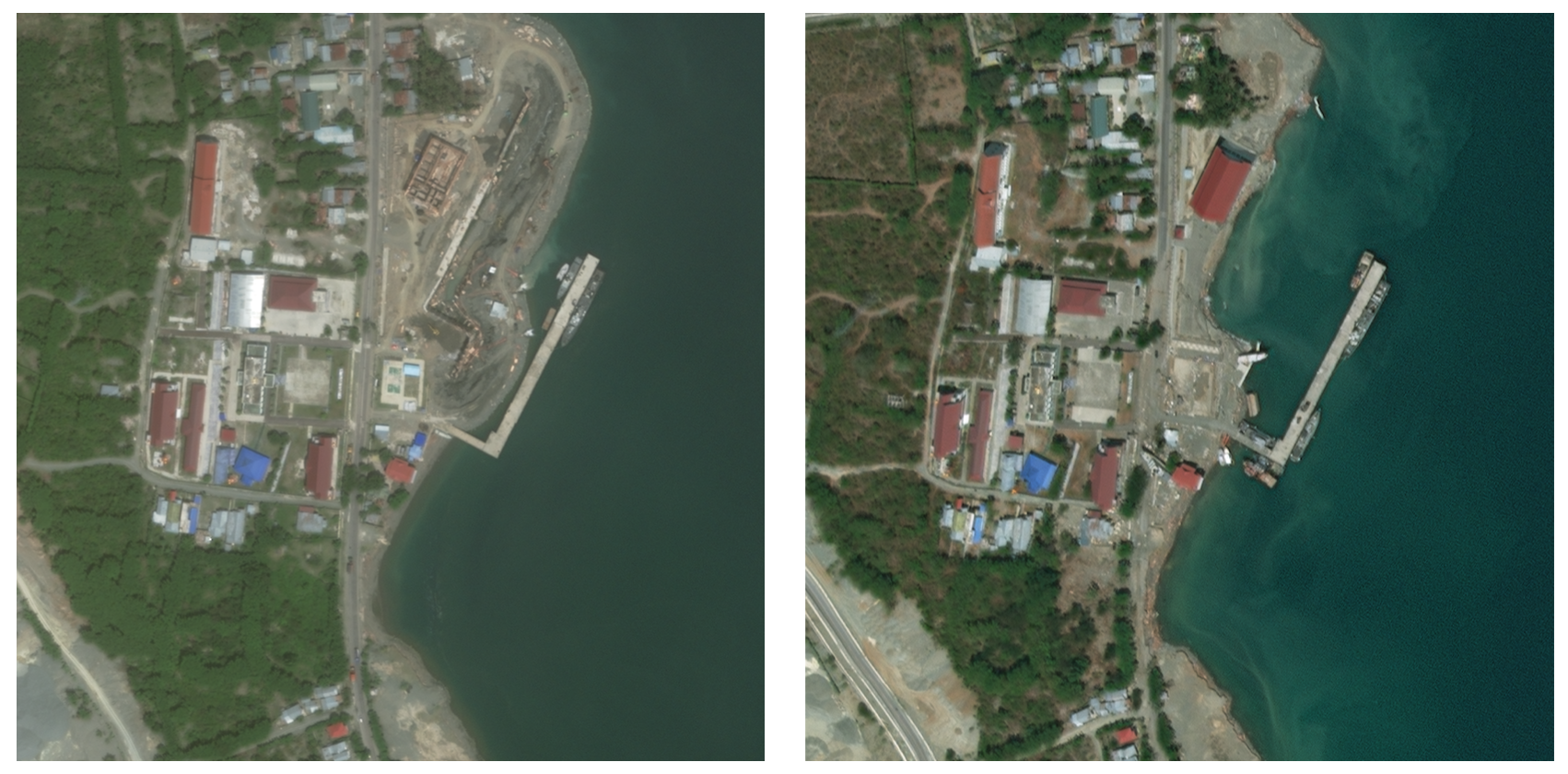
Access to detailed war impact assessments is crucial for humanitarian organizations to effectively assist populations most affected by armed conflicts. However, maintaining a comprehensive understanding of the situation on the ground is challenging, especially in conflicts that cover vast territories and extend over long periods. This study presents a scalable and transferable method for estimating war-induced damage to buildings. We first train a machine learning model to output pixel-wise probability of destruction from Synthetic Aperture Radar (SAR) satellite image time series, leveraging existing, manual damage assessments as ground truth and cloud-based geospatial analysis tools for large-scale inference. We further post-process these assessments using open building footprints to obtain a final damage estimate per building. We introduce an accessible, open-source tool that allows users to adjust the confidence interval based on their specific requirements and use cases. Our approach enables humanitarian organizations and other actors to rapidly screen large geographic regions for war impacts. We provide two publicly accessible dashboards: a Ukraine Damage Explorer to dynamically view our pre-computed estimates, and a Rapid Damage Mapping Tool to easily run our method and produce custom maps.
Read more6/5/2024
0
Open Access Battle Damage Detection via Pixel-Wise T-Test on Sentinel-1 Imagery
Ollie Ballinger
In the context of recent, highly destructive conflicts in Gaza and Ukraine, reliable estimates of building damage are essential for an informed public discourse, human rights monitoring, and humanitarian aid provision. Given the contentious nature of conflict damage assessment, these estimates must be fully reproducible, explainable, and derived from open access data. This paper introduces a new method for building damage detection-- the Pixel-Wise T-Test (PWTT)-- that satisfies these conditions. Using a combination of freely-available synthetic aperture radar imagery and statistical change detection, the PWTT generates accurate conflict damage estimates across a wide area at regular time intervals. Accuracy is assessed using an original dataset of over half a million labeled building footprints spanning 12 cities across Ukraine, Palestine, Syria, and Iraq. Despite being simple and lightweight, the algorithm achieves building-level accuracy statistics (AUC=0.88 across Ukraine, 0.81 in Gaza) rivalling state of the art methods that use deep learning and high resolution imagery. The workflow is open source and deployed entirely within the Google Earth Engine environment, allowing for the generation of interactive Battle Damage Dashboards for Ukraine and Gaza that update in near-real time, allowing the public and humanitarian practitioners to immediately get estimates of damaged buildings in a given area.
Read more5/13/2024
🤿
0
Rapid post-disaster infrastructure damage characterisation enabled by remote sensing and deep learning technologies -- a tiered approach
Nadiia Kopiika, Andreas Karavias, Pavlos Krassakis, Zehao Ye, Jelena Ninic, Nataliya Shakhovska, Nikolaos Koukouzas, Sotirios Argyroudis, Stergios-Aristoteles Mitoulis
Critical infrastructure, such as transport networks and bridges, are systematically targeted during wars and suffer damage during extensive natural disasters because it is vital for enabling connectivity and transportation of people and goods, and hence, underpins national and international economic growth. Mass destruction of transport assets, in conjunction with minimal or no accessibility in the wake of natural and anthropogenic disasters, prevents us from delivering rapid recovery and adaptation. As a result, systemic operability is drastically reduced, leading to low levels of resilience. Thus, there is a need for rapid assessment of its condition to allow for informed decision-making for restoration prioritisation. A solution to this challenge is to use technology that enables stand-off observations. Nevertheless, no methods exist for automated characterisation of damage at multiple scales, i.e. regional (e.g., network), asset (e.g., bridges), and structural (e.g., road pavement) scales. We propose a methodology based on an integrated, multi-scale tiered approach to fill this capability gap. In doing so, we demonstrate how automated damage characterisation can be enabled by fit-for-purpose digital technologies. Next, the methodology is applied and validated to a case study in Ukraine that includes 17 bridges, damaged by human targeted interventions. From regional to component scale, we deploy technology to integrate assessments using Sentinel-1 SAR images, crowdsourced information, and high-resolution images for deep learning to facilitate automatic damage detection and characterisation. For the first time, the interferometric coherence difference and semantic segmentation of images were deployed in a tiered multi-scale approach to improve the reliability of damage characterisations at different scales.
Read more4/15/2024
0
DeepDamageNet: A two-step deep-learning model for multi-disaster building damage segmentation and classification using satellite imagery
Irene Alisjahbana (Mullet), Jiawei Li (Mullet), Ben (Mullet), Strong, Yue Zhang
Satellite imagery has played an increasingly important role in post-disaster building damage assessment. Unfortunately, current methods still rely on manual visual interpretation, which is often time-consuming and can cause very low accuracy. To address the limitations of manual interpretation, there has been a significant increase in efforts to automate the process. We present a solution that performs the two most important tasks in building damage assessment, segmentation and classification, through deep-learning models. We show our results submitted as part of the xView2 Challenge, a competition to design better models for identifying buildings and their damage level after exposure to multiple kinds of natural disasters. Our best model couples a building identification semantic segmentation convolutional neural network (CNN) to a building damage classification CNN, with a combined F1 score of 0.66, surpassing the xView2 challenge baseline F1 score of 0.28. We find that though our model was able to identify buildings with relatively high accuracy, building damage classification across various disaster types is a difficult task due to the visual similarity between different damage levels and different damage distribution between disaster types, highlighting the fact that it may be important to have a probabilistic prior estimate regarding disaster damage in order to obtain accurate predictions.
Read more5/9/2024