Deep Learning for Slum Mapping in Remote Sensing Images: A Meta-analysis and Review
2406.08031
0
0

Abstract
The major Sustainable Development Goals (SDG) 2030, set by the United Nations Development Program (UNDP), include sustainable cities and communities, no poverty, and reduced inequalities. However, millions of people live in slums or informal settlements with poor living conditions in many major cities around the world, especially in less developed countries. To emancipate these settlements and their inhabitants through government intervention, accurate data about slum location and extent is required. While ground survey data is the most reliable, such surveys are costly and time-consuming. An alternative is remotely sensed data obtained from very high-resolution (VHR) imagery. With the advancement of new technology, remote sensing based mapping of slums has emerged as a prominent research area. The parallel rise of Artificial Intelligence, especially Deep Learning has added a new dimension to this field as it allows automated analysis of satellite imagery to identify complex spatial patterns associated with slums. This article offers a detailed review and meta-analysis of research on slum mapping using remote sensing imagery from 2014 to 2024, with a special focus on deep learning approaches. Our analysis reveals a trend towards increasingly complex neural network architectures, with advancements in data preprocessing and model training techniques significantly enhancing slum identification accuracy. We have attempted to identify key methodologies that are effective across diverse geographic contexts. While acknowledging the transformative impact Convolutional Neural Networks (CNNs) in slum detection, our review underscores the absence of a universally optimal model, suggesting the need for context-specific adaptations. We also identify prevailing challenges in this field, such as data limitations and a lack of model explainability and suggest potential strategies for overcoming these.
Create account to get full access
Overview
- This paper provides a meta-analysis and review of the use of deep learning techniques for mapping slums in remote sensing images.
- The authors examine the existing research on this topic, summarize the key findings, and identify areas for future work.
- The paper covers topics such as data sources, model architectures, performance metrics, and real-world applications of deep learning for slum mapping.
Plain English Explanation
Deep learning is a type of artificial intelligence that can be used to analyze and understand complex data, such as satellite or aerial images. In this paper, the researchers looked at how deep learning has been used to identify and map areas of informal settlements, often called "slums," in remote sensing images.
Slums are densely populated urban areas that lack basic services and infrastructure, and they are a major challenge in many developing countries. Accurately mapping the location and extent of slums is important for urban planning and providing essential services to these communities.
The researchers reviewed a large number of studies that have used deep learning techniques to detect and delineate slum areas from satellite or drone imagery. They summarized the key findings, such as the types of data and models that have been used, the performance of these systems, and how the results have been applied in real-world scenarios.
By compiling and analyzing this research, the authors were able to identify both the strengths and limitations of the current deep learning approaches for slum mapping. They also suggested areas where further work is needed to improve the accuracy and applicability of these techniques.
This review provides a valuable synthesis of the state of the art in deep learning for slum mapping, which can help guide future research and practical applications in this important domain.
Technical Explanation
The paper begins by providing an overview of the problem of slum mapping and the role that remote sensing and deep learning can play in addressing it. The authors then conduct a systematic review of the existing literature on this topic, focusing on studies that have used deep learning techniques to detect and delineate slum areas from satellite or aerial imagery.
The researchers categorize the reviewed studies based on factors such as the data sources used (e.g., high-resolution satellite imagery, UAV imagery), the deep learning architectures employed (e.g., convolutional neural networks, [recurrent neural networks]), and the performance metrics reported (e.g., accuracy, F1-score, IoU).
The review also examines the real-world applications of these deep learning-based slum mapping methods, such as informing urban planning, targeting service delivery, and monitoring changes over time. The authors discuss how the outputs of these systems have been integrated into decision-making processes and the challenges involved in transitioning from research to operational use.
Finally, the paper identifies several areas for future research, including the need for more standardized evaluation protocols, the integration of multi-modal data sources, and the development of explainable AI techniques to better understand the underlying factors contributing to slum formation and growth.
Critical Analysis
The meta-analysis presented in this paper provides a comprehensive overview of the current state of deep learning for slum mapping, highlighting both the progress made and the significant challenges that remain. The authors have carefully synthesized a large body of research, which is a valuable contribution to the field.
One potential limitation of the review is that it may not capture the most recent developments, as the paper appears to have been written before the latest advancements in deep learning and remote sensing technologies. It would be interesting to see how the authors' findings and recommendations hold up as the field continues to evolve.
Additionally, while the paper covers a range of data sources and model architectures, it does not delve deeply into the relative merits and trade-offs of different approaches. A more detailed comparative analysis of the strengths and weaknesses of various deep learning techniques for slum mapping could provide further insights for researchers and practitioners.
The authors also acknowledge the challenges of transitioning deep learning-based slum mapping systems from research to operational use, such as the need for robust and scalable data collection and processing pipelines. These practical considerations are important and warrant further discussion.
Overall, this meta-analysis serves as a valuable reference for anyone interested in the application of deep learning to the challenging problem of slum mapping. By highlighting the current state of the art and identifying areas for future research, the paper lays the groundwork for continued progress in this important field.
Conclusion
This paper provides a comprehensive meta-analysis and review of the use of deep learning techniques for mapping slums in remote sensing images. The authors have synthesized a large body of research, summarizing the key findings, performance metrics, and real-world applications of these methods.
The review highlights the significant progress that has been made in using deep learning to detect and delineate slum areas from satellite and aerial imagery. However, it also identifies several areas for future research, such as the need for more standardized evaluation protocols, the integration of multi-modal data sources, and the development of explainable AI techniques.
By bringing together and critically analyzing the existing literature, this paper provides a valuable resource for researchers and practitioners working in the field of slum mapping and urban planning. The insights and recommendations presented can help guide the continued development and deployment of deep learning-based solutions to address this important challenge.
This summary was produced with help from an AI and may contain inaccuracies - check out the links to read the original source documents!
Related Papers
Automated National Urban Map Extraction
Hasan Nasrallah, Abed Ellatif Samhat, Cristiano Nattero, Ali J. Ghandour
0
0
Developing countries usually lack the proper governance means to generate and regularly update a national rooftop map. Using traditional photogrammetry and surveying methods to produce a building map at the federal level is costly and time consuming. Using earth observation and deep learning methods, we can bridge this gap and propose an automated pipeline to fetch such national urban maps. This paper aims to exploit the power of fully convolutional neural networks for multi-class buildings' instance segmentation to leverage high object-wise accuracy results. Buildings' instance segmentation from sub-meter high-resolution satellite images can be achieved with relatively high pixel-wise metric scores. We detail all engineering steps to replicate this work and ensure highly accurate results in dense and slum areas witnessed in regions that lack proper urban planning in the Global South. We applied a case study of the proposed pipeline to Lebanon and successfully produced the first comprehensive national building footprint map with approximately 1 Million units with an 84% accuracy. The proposed architecture relies on advanced augmentation techniques to overcome dataset scarcity, which is often the case in developing countries.
5/6/2024
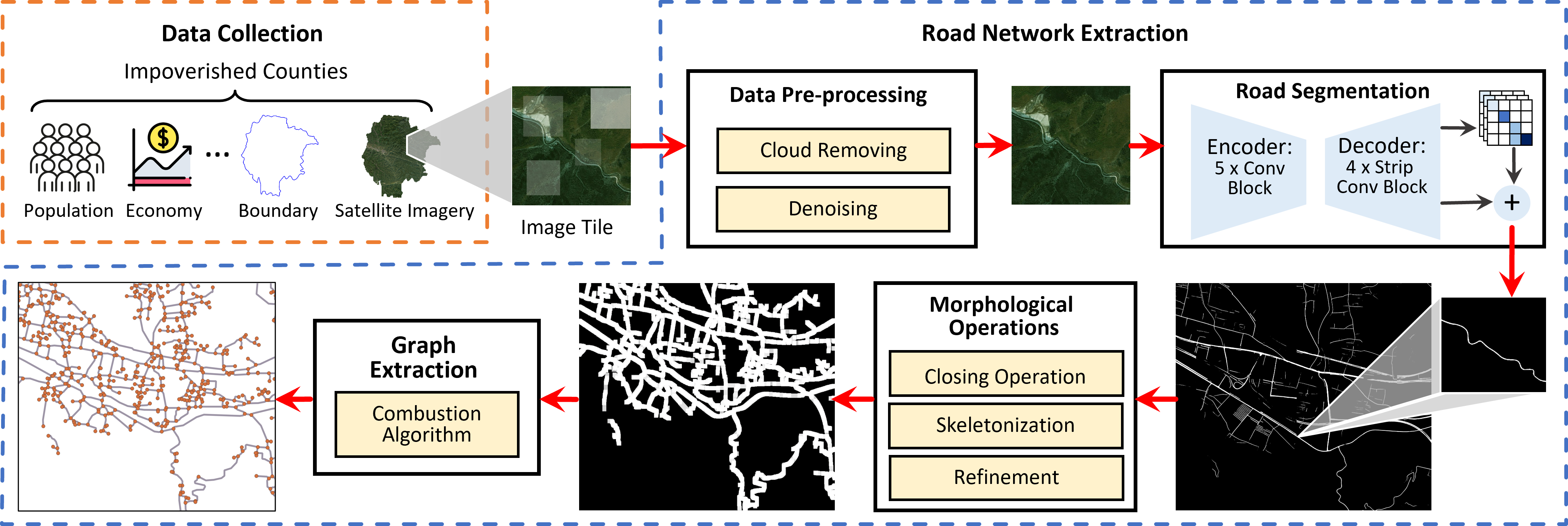
From Pixels to Progress: Generating Road Network from Satellite Imagery for Socioeconomic Insights in Impoverished Areas
Yanxin Xi, Yu Liu, Zhicheng Liu, Sasu Tarkoma, Pan Hui, Yong Li
0
0
The Sustainable Development Goals (SDGs) aim to resolve societal challenges, such as eradicating poverty and improving the lives of vulnerable populations in impoverished areas. Those areas rely on road infrastructure construction to promote accessibility and economic development. Although publicly available data like OpenStreetMap is available to monitor road status, data completeness in impoverished areas is limited. Meanwhile, the development of deep learning techniques and satellite imagery shows excellent potential for earth monitoring. To tackle the challenge of road network assessment in impoverished areas, we develop a systematic road extraction framework combining an encoder-decoder architecture and morphological operations on satellite imagery, offering an integrated workflow for interdisciplinary researchers. Extensive experiments of road network extraction on real-world data in impoverished regions achieve a 42.7% enhancement in the F1-score over the baseline methods and reconstruct about 80% of the actual roads. We also propose a comprehensive road network dataset covering approximately 794,178 km2 area and 17.048 million people in 382 impoverished counties in China. The generated dataset is further utilized to conduct socioeconomic analysis in impoverished counties, showing that road network construction positively impacts regional economic development. The technical appendix, code, and generated dataset can be found at https://github.com/tsinghua-fib-lab/Road_network_extraction_impoverished_counties.
6/18/2024

Comparing Deep Learning Models for Rice Mapping in Bhutan Using High Resolution Satellite Imagery
Biplov Bhandari, Timothy Mayer
0
0
The Bhutanese government is increasing its utilization of technological approaches such as including Remote Sensing-based knowledge in their decision-making process. This study focuses on crop type and crop extent in Paro, one of the top rice-yielding districts in Bhutan, and employs publicly available NICFI high-resolution satellite imagery from Planet. Two Deep Learning (DL) approaches, point-based (DNN) and patch-based (U-Net), models were used in conjunction with cloud-computing platforms. Three different models per DL approaches (DNN and U-Net) were trained: 1) RGBN channels from Planet; 2) RGBN and elevation data (RGBNE); 3) RGBN and Sentinel-1 (S1) data (RGBNS), and RGBN with E and S1 data (RGBNES). From this comprehensive analysis, the U-Net displayed higher performance metrics across both model training and model validation efforts. Among the U-Net model sets, the RGBN, RGBNE, RGBNS, and RGBNES models had an F1-score of 0.8546, 0.8563, 0.8467, and 0.8500 respectively. An independent model evaluation was performed and found a high level of performance variation across all the metrics. For this independent model evaluation, the U-Net RGBN, RGBNE, RGBNES, and RGBN models displayed the F1-scores of 0.5935, 0.6154, 0.5882, and 0.6582, suggesting U-Net RGBNES as the best model. The study shows that the DL approaches can predict rice. Also, DL methods can be used with the survey-based approaches currently utilized by the Bhutan Department of Agriculture. Further, this study demonstrated the usage of regional land cover products such as SERVIR's RLCMS as a weak label approach to capture different strata addressing the class imbalance problem and improving the sampling design for DL application. Finally, through preliminary model testing and comparisons outlined it was shown that using additional features such as NDVI, EVI, and NDWI did not drastically improve model performance.
6/12/2024

Global Mapping of Exposure and Physical Vulnerability Dynamics in Least Developed Countries using Remote Sensing and Machine Learning
Joshua Dimasaka, Christian Gei{ss}, Emily So
0
0
As the world marked the midterm of the Sendai Framework for Disaster Risk Reduction 2015-2030, many countries are still struggling to monitor their climate and disaster risk because of the expensive large-scale survey of the distribution of exposure and physical vulnerability and, hence, are not on track in reducing risks amidst the intensifying effects of climate change. We present an ongoing effort in mapping this vital information using machine learning and time-series remote sensing from publicly available Sentinel-1 SAR GRD and Sentinel-2 Harmonized MSI. We introduce the development of OpenSendaiBench consisting of 47 countries wherein most are least developed (LDCs), trained ResNet-50 deep learning models, and demonstrated the region of Dhaka, Bangladesh by mapping the distribution of its informal constructions. As a pioneering effort in auditing global disaster risk over time, this paper aims to advance the area of large-scale risk quantification in informing our collective long-term efforts in reducing climate and disaster risk.
4/3/2024