GroundGrid:LiDAR Point Cloud Ground Segmentation and Terrain Estimation

0
Sign in to get full access
Overview
- This paper presents GroundGrid, a method for segmenting the ground points and estimating terrain in LiDAR point clouds.
- The researchers use a combination of grid-based processing and deep learning to accurately identify the ground points, even in complex outdoor environments.
- The proposed approach outperforms several state-of-the-art methods on benchmark datasets, demonstrating its effectiveness for a range of applications like autonomous navigation and terrain mapping.
Plain English Explanation
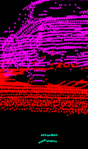
LiDAR (Light Detection and Ranging) is a remote sensing technology that uses laser beams to measure distances and create detailed 3D maps of the environment. These 3D maps, called point clouds, contain vast amounts of information about the surrounding terrain, buildings, vegetation, and other objects.
One crucial step in processing LiDAR point clouds is to identify the ground points - the points that represent the actual ground or terrain surface. This is important for many applications, such as autonomous vehicle navigation, 3D reconstruction, and terrain mapping.
The GroundGrid method proposed in this paper uses a two-step approach to accurately segment the ground points in a LiDAR point cloud. First, it divides the point cloud into a grid of cells and processes each cell individually to identify the ground points. Then, it uses a deep learning model to refine the ground segmentation and estimate the terrain surface.
The key advantage of GroundGrid is its ability to handle complex outdoor environments with varied terrain, vegetation, and other obstacles. By combining the grid-based processing and deep learning, the method can accurately separate the ground points from the rest of the point cloud, even in challenging scenarios where other approaches may struggle.
Technical Explanation
The GroundGrid method consists of two main components: a grid-based ground segmentation algorithm and a deep learning-based terrain estimation module.
The grid-based ground segmentation algorithm works by dividing the input LiDAR point cloud into a grid of cells. For each cell, it applies a series of rules to identify the ground points, taking into account factors such as point density, height differences, and local curvature. This grid-based approach allows the algorithm to handle variations in terrain and vegetation within the point cloud.
The deep learning-based terrain estimation module takes the segmented ground points and uses a convolutional neural network to predict a dense terrain elevation map. This terrain estimation component helps to smooth out any irregularities or errors in the initial ground segmentation, further improving the overall accuracy of the method.
The researchers evaluated GroundGrid on several benchmark datasets, including the OpenTrench3D and Terrain-Informed datasets. The results showed that GroundGrid outperformed several state-of-the-art ground segmentation and terrain estimation methods, demonstrating its effectiveness for a range of real-world applications.
Critical Analysis
The paper presents a comprehensive evaluation of GroundGrid, highlighting its strengths in handling complex outdoor environments. However, the authors also acknowledge some limitations of the approach. For example, the grid-based processing may struggle with very sparse point clouds or regions with abrupt terrain changes, and the deep learning model requires a significant amount of training data to achieve optimal performance.
Additionally, the paper does not discuss the computational efficiency of GroundGrid, which could be an important consideration for real-time applications or resource-constrained systems. Further research may be needed to explore ways to optimize the algorithm's speed and memory usage.
Overall, GroundGrid represents a promising approach for LiDAR point cloud processing, with its ability to accurately segment the ground points and estimate the terrain surface. However, as with any research, there is room for improvement and further exploration to address the identified limitations and expand the method's capabilities.
Conclusion
The GroundGrid method presented in this paper offers a robust and effective solution for segmenting the ground points and estimating the terrain in LiDAR point clouds. By combining grid-based processing and deep learning, the approach can handle complex outdoor environments and outperform state-of-the-art methods on benchmark datasets.
The successful application of GroundGrid has the potential to drive advancements in a wide range of domains, from autonomous navigation and robotics to environmental mapping and monitoring. As the use of LiDAR technology continues to grow, tools like GroundGrid will become increasingly important for extracting valuable insights from the massive amounts of 3D data being collected.
This summary was produced with help from an AI and may contain inaccuracies - check out the links to read the original source documents!
Related Papers
0
GroundGrid:LiDAR Point Cloud Ground Segmentation and Terrain Estimation
Nicolai Steinke, Daniel Gohring, Ra`ul Rojas
The precise point cloud ground segmentation is a crucial prerequisite of virtually all perception tasks for LiDAR sensors in autonomous vehicles. Especially the clustering and extraction of objects from a point cloud usually relies on an accurate removal of ground points. The correct estimation of the surrounding terrain is important for aspects of the drivability of a surface, path planning, and obstacle prediction. In this article, we propose our system GroundGrid which relies on 2D elevation maps to solve the terrain estimation and point cloud ground segmentation problems. We evaluate the ground segmentation and terrain estimation performance of GroundGrid and compare it to other state-of-the-art methods using the SemanticKITTI dataset and a novel evaluation method relying on airborne LiDAR scanning. The results show that GroundGrid is capable of outperforming other state-of-the-art systems with an average IoU of 94.78% while maintaining a high run-time performance of 171Hz. The source code is available at https://github.com/dcmlr/groundgrid
Read more5/27/2024

0
UdeerLID+: Integrating LiDAR, Image, and Relative Depth with Semi-Supervised
Tao Ni, Xin Zhan, Tao Luo, Wenbin Liu, Zhan Shi, JunBo Chen
Road segmentation is a critical task for autonomous driving systems, requiring accurate and robust methods to classify road surfaces from various environmental data. Our work introduces an innovative approach that integrates LiDAR point cloud data, visual image, and relative depth maps derived from images. The integration of multiple data sources in road segmentation presents both opportunities and challenges. One of the primary challenges is the scarcity of large-scale, accurately labeled datasets that are necessary for training robust deep learning models. To address this, we have developed the [UdeerLID+] framework under a semi-supervised learning paradigm. Experiments results on KITTI datasets validate the superior performance.
Read more9/11/2024
🔄
0
Attention-Guided Lidar Segmentation and Odometry Using Image-to-Point Cloud Saliency Transfer
Guanqun Ding, Nevrez Imamoglu, Ali Caglayan, Masahiro Murakawa, Ryosuke Nakamura
LiDAR odometry estimation and 3D semantic segmentation are crucial for autonomous driving, which has achieved remarkable advances recently. However, these tasks are challenging due to the imbalance of points in different semantic categories for 3D semantic segmentation and the influence of dynamic objects for LiDAR odometry estimation, which increases the importance of using representative/salient landmarks as reference points for robust feature learning. To address these challenges, we propose a saliency-guided approach that leverages attention information to improve the performance of LiDAR odometry estimation and semantic segmentation models. Unlike in the image domain, only a few studies have addressed point cloud saliency information due to the lack of annotated training data. To alleviate this, we first present a universal framework to transfer saliency distribution knowledge from color images to point clouds, and use this to construct a pseudo-saliency dataset (i.e. FordSaliency) for point clouds. Then, we adopt point cloud-based backbones to learn saliency distribution from pseudo-saliency labels, which is followed by our proposed SalLiDAR module. SalLiDAR is a saliency-guided 3D semantic segmentation model that integrates saliency information to improve segmentation performance. Finally, we introduce SalLONet, a self-supervised saliency-guided LiDAR odometry network that uses the semantic and saliency predictions of SalLiDAR to achieve better odometry estimation. Our extensive experiments on benchmark datasets demonstrate that the proposed SalLiDAR and SalLONet models achieve state-of-the-art performance against existing methods, highlighting the effectiveness of image-to-LiDAR saliency knowledge transfer. Source code will be available at https://github.com/nevrez/SalLONet.
Read more6/18/2024

0
CurbNet: Curb Detection Framework Based on LiDAR Point Cloud Segmentation
Guoyang Zhao, Fulong Ma, Weiqing Qi, Yuxuan Liu, Ming Liu
Curb detection is a crucial function in intelligent driving, essential for determining drivable areas on the road. However, the complexity of road environments makes curb detection challenging. This paper introduces CurbNet, a novel framework for curb detection utilizing point cloud segmentation. To address the lack of comprehensive curb datasets with 3D annotations, we have developed the 3D-Curb dataset based on SemanticKITTI, currently the largest and most diverse collection of curb point clouds. Recognizing that the primary characteristic of curbs is height variation, our approach leverages spatially rich 3D point clouds for training. To tackle the challenges posed by the uneven distribution of curb features on the xy-plane and their dependence on high-frequency features along the z-axis, we introduce the Multi-Scale and Channel Attention (MSCA) module, a customized solution designed to optimize detection performance. Additionally, we propose an adaptive weighted loss function group specifically formulated to counteract the imbalance in the distribution of curb point clouds relative to other categories. Extensive experiments conducted on 2 major datasets demonstrate that our method surpasses existing benchmarks set by leading curb detection and point cloud segmentation models. Through the post-processing refinement of the detection results, we have significantly reduced noise in curb detection, thereby improving precision by 4.5 points. Similarly, our tolerance experiments also achieved state-of-the-art results. Furthermore, real-world experiments and dataset analyses mutually validate each other, reinforcing CurbNet's superior detection capability and robust generalizability. The project website is available at: https://github.com/guoyangzhao/CurbNet/.
Read more5/31/2024