MS-Mapping: An Uncertainty-Aware Large-Scale Multi-Session LiDAR Mapping System

0

Sign in to get full access
Overview
- This paper presents MS-Mapping, a large-scale multi-session LiDAR mapping system that is uncertainty-aware.
- It focuses on the problem of building consistent and accurate 3D maps from multiple LiDAR data collection sessions.
- The system leverages a pose graph optimization framework to fuse data from multiple mapping sessions while accounting for uncertainty.
Plain English Explanation
The paper describes a system called MS-Mapping that is designed to create detailed 3D maps from multiple sets of LiDAR data collected over time. LiDAR is a technology that uses laser beams to measure the distance to objects, allowing it to capture detailed 3D information about a physical environment.
The key challenge the researchers address is how to combine multiple LiDAR data collection sessions into a single, consistent 3D map. This is important because LiDAR data can be affected by various sources of uncertainty, such as sensor errors or changes in the environment between sessions. By accounting for these uncertainties, MS-Mapping is able to fuse the data in a way that results in a more accurate and reliable final map.
At the heart of the system is a pose graph optimization framework, which is a way of representing the relationship between different sensor measurements and using mathematical techniques to find the best alignment of all the data. This allows MS-Mapping to build a 3D map that is consistent across multiple data collection sessions, even in large-scale environments.
Technical Explanation
The MS-Mapping system uses a pose graph optimization framework to fuse LiDAR data from multiple mapping sessions. The pose graph represents the spatial relationships between sensor measurements, with nodes corresponding to LiDAR scans and edges representing the relative poses (positions and orientations) between them.
To handle uncertainty, the system models the sensor errors and environment changes using multivariate Gaussian distributions. This probabilistic representation allows the optimization to find the most likely alignment of all the LiDAR data, taking into account the uncertainties.
The optimization process iteratively adjusts the poses of the LiDAR scans to minimize the overall error in the pose graph, resulting in a globally consistent 3D map. The system also includes techniques for loop closure to detect when the robot has revisited a previously mapped area and incorporate that information into the optimization.
Critical Analysis
The paper demonstrates the effectiveness of the MS-Mapping system through extensive experiments in large-scale outdoor environments. However, it acknowledges some limitations:
- The system assumes the availability of accurate initial pose estimates for the LiDAR scans, which may not always be the case in real-world scenarios.
- The computational complexity of the optimization process may limit the scalability of the system to extremely large environments.
Additionally, the paper does not address potential issues related to dynamic elements in the environment, such as moving objects, which could introduce further challenges for the mapping system.
Conclusion
The MS-Mapping system presents a robust and uncertainty-aware approach to building large-scale 3D maps from multiple LiDAR data collection sessions. By leveraging pose graph optimization and probabilistic modeling of sensor errors, the system is able to fuse the data in a way that results in a more accurate and consistent final map. This technology has important applications in areas such as autonomous navigation, urban planning, and environmental monitoring, where detailed and reliable 3D maps are crucial.
This summary was produced with help from an AI and may contain inaccuracies - check out the links to read the original source documents!
Related Papers
0
MS-Mapping: An Uncertainty-Aware Large-Scale Multi-Session LiDAR Mapping System
Xiangcheng Hu, Jin Wu, Jianhao Jiao, Binqian Jiang, Wei Zhang, Wenshuo Wang, Ping Tan
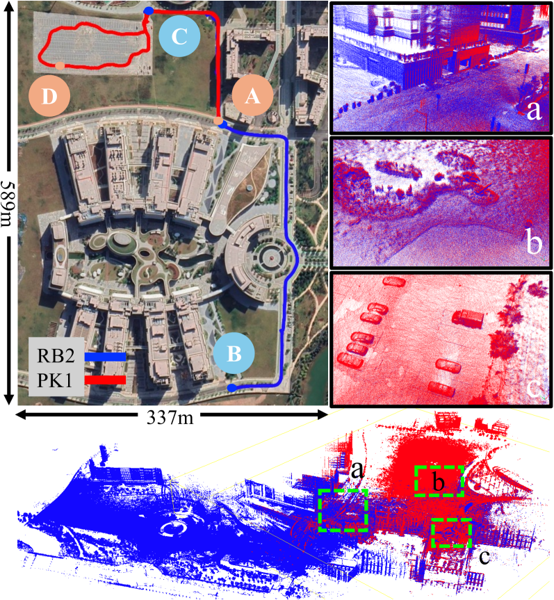
Large-scale multi-session LiDAR mapping is essential for a wide range of applications, including surveying, autonomous driving, crowdsourced mapping, and multi-agent navigation. However, existing approaches often struggle with data redundancy, robustness, and accuracy in complex environments. To address these challenges, we present MS-Mapping, an novel multi-session LiDAR mapping system that employs an incremental mapping scheme for robust and accurate map assembly in large-scale environments. Our approach introduces three key innovations: 1) A distribution-aware keyframe selection method that captures the subtle contributions of each point cloud frame to the map by analyzing the similarity of map distributions. This method effectively reduces data redundancy and pose graph size, while enhancing graph optimization speed; 2) An uncertainty model that automatically performs least-squares adjustments according to the covariance matrix during graph optimization, improving mapping precision, robustness, and flexibility without the need for scene-specific parameter tuning. This uncertainty model enables our system to monitor pose uncertainty and avoid ill-posed optimizations, thereby increasing adaptability to diverse and challenging environments. 3) To ensure fair evaluation, we redesign baseline comparisons and the evaluation benchmark. Direct assessment of map accuracy demonstrates the superiority of the proposed MS-Mapping algorithm compared to state-of-the-art methods. In addition to employing public datasets such as Urban-Nav, FusionPortable, and Newer College, we conducted extensive experiments on such a large SI{855}{m}$times$SI{636}{m} ground truth map, collecting over SI{20}{km} of indoor and outdoor data across more than ten sequences...
Read more8/9/2024
0
MS-Mapping: Multi-session LiDAR Mapping with Wasserstein-based Keyframe Selection
Xiangcheng Hu, Jin Wu, Jianhao Jiao, Wei Zhang, Ping Tan
Large-scale multi-session LiDAR mapping is crucial for various applications but still faces significant challenges in data redundancy, memory consumption, and efficiency. This paper presents MS-Mapping, a novel multi-session LiDAR mapping system that incorporates an incremental mapping scheme to enable efficient map assembly in large-scale environments. To address the data redundancy and improve graph optimization efficiency caused by the vast amount of point cloud data, we introduce a real-time keyframe selection method based on the Wasserstein distance. Our approach formulates the LiDAR point cloud keyframe selection problem using a similarity method based on Gaussian mixture models (GMM) and addresses the real-time challenge by employing an incremental voxel update method. To facilitate further research and development in the community, we make our codefootnote{https://github.com/JokerJohn/MS-Mapping} and datasets publicly available.
Read more7/18/2024

0
SLIM: Scalable and Lightweight LiDAR Mapping in Urban Environments
Zehuan Yu, Zhijian Qiao, Wenyi Liu, Huan Yin, Shaojie Shen
LiDAR point cloud maps are extensively utilized on roads for robot navigation due to their high consistency. However, dense point clouds face challenges of high memory consumption and reduced maintainability for long-term operations. In this study, we introduce SLIM, a scalable and lightweight mapping system for long-term LiDAR mapping in urban environments. The system begins by parameterizing structural point clouds into lines and planes. These lightweight and structural representations meet the requirements of map merging, pose graph optimization, and bundle adjustment, ensuring incremental management and local consistency. For long-term operations, a map-centric nonlinear factor recovery method is designed to sparsify poses while preserving mapping accuracy. We validate the SLIM system with multi-session real-world LiDAR data from classical LiDAR mapping datasets, including KITTI, NCLT, and HeLiPR. The experiments demonstrate its capabilities in mapping accuracy, lightweightness, and scalability. Map re-use is also verified through map-based robot localization. Ultimately, with multi-session LiDAR data, the SLIM system provides a globally consistent map with low memory consumption (130 KB/km). We have made our code open-source to benefit the community.
Read more9/16/2024

0
Multi-Modal Data-Efficient 3D Scene Understanding for Autonomous Driving
Lingdong Kong, Xiang Xu, Jiawei Ren, Wenwei Zhang, Liang Pan, Kai Chen, Wei Tsang Ooi, Ziwei Liu
Efficient data utilization is crucial for advancing 3D scene understanding in autonomous driving, where reliance on heavily human-annotated LiDAR point clouds challenges fully supervised methods. Addressing this, our study extends into semi-supervised learning for LiDAR semantic segmentation, leveraging the intrinsic spatial priors of driving scenes and multi-sensor complements to augment the efficacy of unlabeled datasets. We introduce LaserMix++, an evolved framework that integrates laser beam manipulations from disparate LiDAR scans and incorporates LiDAR-camera correspondences to further assist data-efficient learning. Our framework is tailored to enhance 3D scene consistency regularization by incorporating multi-modality, including 1) multi-modal LaserMix operation for fine-grained cross-sensor interactions; 2) camera-to-LiDAR feature distillation that enhances LiDAR feature learning; and 3) language-driven knowledge guidance generating auxiliary supervisions using open-vocabulary models. The versatility of LaserMix++ enables applications across LiDAR representations, establishing it as a universally applicable solution. Our framework is rigorously validated through theoretical analysis and extensive experiments on popular driving perception datasets. Results demonstrate that LaserMix++ markedly outperforms fully supervised alternatives, achieving comparable accuracy with five times fewer annotations and significantly improving the supervised-only baselines. This substantial advancement underscores the potential of semi-supervised approaches in reducing the reliance on extensive labeled data in LiDAR-based 3D scene understanding systems.
Read more5/9/2024