OAM-TCD: A globally diverse dataset of high-resolution tree cover maps

0
Sign in to get full access
Overview
- This paper presents OAM-TCD, a large-scale, globally diverse dataset of high-resolution tree cover maps.
- The dataset is designed to address challenges in global tree detection, including diverse environments, data scarcity, and model generalization issues.
- OAM-TCD covers a wide range of ecosystems and geographies, providing a comprehensive benchmark for tree cover mapping algorithms.
Plain English Explanation
Detecting and mapping trees on a global scale is a challenging task for researchers and organizations working on environmental conservation and urban planning. The OAM-TCD dataset aims to address these challenges by providing a diverse and comprehensive collection of high-resolution tree cover maps.
The dataset covers a wide range of ecosystems, from tropical rainforests to temperate deciduous forests, and different geographical regions around the world. This diversity is important because tree detection algorithms that work well in one environment may not perform as well in another. By having a large and varied dataset, researchers can develop more robust and generalizable models that can be applied effectively in different parts of the world.
The OAM-TCD dataset also helps address the problem of data scarcity, which is a common issue in tree detection research. Many existing datasets are limited in their geographic coverage or the types of environments they represent. By creating a large, globally diverse dataset, the researchers behind OAM-TCD aim to provide a more comprehensive resource for the scientific community to train and test their tree detection algorithms.
Technical Explanation
The OAM-TCD dataset was created by combining multiple sources of high-resolution satellite imagery, including data from the Copernicus Sentinel-2 mission and other commercial providers. The researchers then used a combination of manual and automated techniques to annotate the imagery and create detailed tree cover maps.
The dataset covers a wide range of environments, including tropical, subtropical, temperate, and boreal forests, as well as urban and agricultural areas. This diversity is important for ensuring that tree detection algorithms developed using OAM-TCD can generalize well to different types of landscapes and ecosystems.
The OAM-TCD dataset also includes metadata such as climate, soil, and topographic information, which can be used to analyze the performance of tree detection algorithms in different environmental conditions. This can help researchers identify the factors that influence the accuracy and robustness of their models.
Critical Analysis
One potential limitation of the OAM-TCD dataset is the reliance on satellite imagery, which may not capture all the details and nuances of tree cover, especially in dense or complex canopies. The researchers acknowledge this issue and suggest that the dataset could be complemented with other data sources, such as high-resolution land use land cover maps, to provide a more comprehensive understanding of global tree cover.
Additionally, while the dataset covers a wide range of environments, there may still be some geographic regions or ecosystem types that are underrepresented. Researchers should be mindful of this when using the dataset and consider the potential biases it may introduce into their models.
Conclusion
The OAM-TCD dataset represents a significant contribution to the field of global tree detection and mapping. By providing a large, diverse, and high-quality dataset, the researchers have created a valuable resource for the scientific community to develop and evaluate tree detection algorithms. This, in turn, can lead to improved environmental monitoring, urban planning, and conservation efforts worldwide.
This summary was produced with help from an AI and may contain inaccuracies - check out the links to read the original source documents!
Related Papers
0
OAM-TCD: A globally diverse dataset of high-resolution tree cover maps
Josh Veitch-Michaelis, Andrew Cottam, Daniella Schweizer, Eben N. Broadbent, David Dao, Ce Zhang, Angelica Almeyda Zambrano, Simeon Max
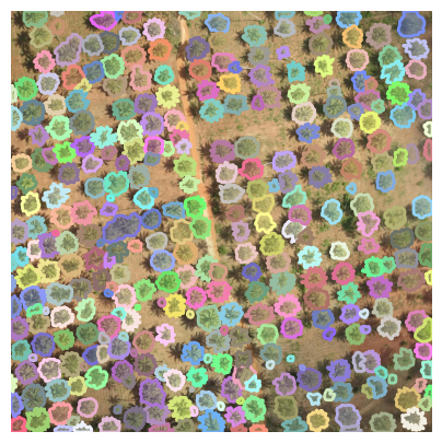
Accurately quantifying tree cover is an important metric for ecosystem monitoring and for assessing progress in restored sites. Recent works have shown that deep learning-based segmentation algorithms are capable of accurately mapping trees at country and continental scales using high-resolution aerial and satellite imagery. Mapping at high (ideally sub-meter) resolution is necessary to identify individual trees, however there are few open-access datasets containing instance level annotations and those that exist are small or not geographically diverse. We present a novel open-access dataset for individual tree crown delineation (TCD) in high-resolution aerial imagery sourced from OpenAerialMap (OAM). Our dataset, OAM-TCD, comprises 5072 2048x2048 px images at 10 cm/px resolution with associated human-labeled instance masks for over 280k individual and 56k groups of trees. By sampling imagery from around the world, we are able to better capture the diversity and morphology of trees in different terrestrial biomes and in both urban and natural environments. Using our dataset, we train reference instance and semantic segmentation models that compare favorably to existing state-of-the-art models. We assess performance through k-fold cross-validation and comparison with existing datasets; additionally we demonstrate compelling results on independent aerial imagery captured over Switzerland and compare to municipal tree inventories and LIDAR-derived canopy maps in the city of Zurich. Our dataset, models and training/benchmark code are publicly released under permissive open-source licenses: Creative Commons (majority CC BY 4.0), and Apache 2.0 respectively.
Read more7/17/2024
🔎
0
Individual Tree Detection in Large-Scale Urban Environments using High-Resolution Multispectral Imagery
Jonathan Ventura, Camille Pawlak, Milo Honsberger, Cameron Gonsalves, Julian Rice, Natalie L. R. Love, Skyler Han, Viet Nguyen, Keilana Sugano, Jacqueline Doremus, G. Andrew Fricker, Jenn Yost, Matt Ritter
We introduce a novel deep learning method for detection of individual trees in urban environments using high-resolution multispectral aerial imagery. We use a convolutional neural network to regress a confidence map indicating the locations of individual trees, which are localized using a peak finding algorithm. Our method provides complete spatial coverage by detecting trees in both public and private spaces, and can scale to very large areas. We performed a thorough evaluation of our method, supported by a new dataset of over 1,500 images and almost 100,000 tree annotations, covering eight cities, six climate zones, and three image capture years. We trained our model on data from Southern California, and achieved a precision of 73.6% and recall of 73.3% using test data from this region. We generally observed similar precision and slightly lower recall when extrapolating to other California climate zones and image capture dates. We used our method to produce a map of trees in the entire urban forest of California, and estimated the total number of urban trees in California to be about 43.5 million. Our study indicates the potential for deep learning methods to support future urban forestry studies at unprecedented scales.
Read more7/4/2024
⚙️
0
Open-Canopy: A Country-Scale Benchmark for Canopy Height Estimation at Very High Resolution
Fajwel Fogel, Yohann Perron, Nikola Besic, Laurent Saint-Andr'e, Agn`es Pellissier-Tanon, Martin Schwartz, Thomas Boudras, Ibrahim Fayad, Alexandre d'Aspremont, Loic Landrieu, Philippe Ciais
Estimating canopy height and canopy height change at meter resolution from satellite imagery has numerous applications, such as monitoring forest health, logging activities, wood resources, and carbon stocks. However, many existing forest datasets are based on commercial or closed data sources, restricting the reproducibility and evaluation of new approaches. To address this gap, we introduce Open-Canopy, the first open-access and country-scale benchmark for very high resolution (1.5 m) canopy height estimation. Covering more than 87,000 km$^2$ across France, Open-Canopy combines SPOT satellite imagery with high resolution aerial LiDAR data. We also propose Open-Canopy-$Delta$, the first benchmark for canopy height change detection between two images taken at different years, a particularly challenging task even for recent models. To establish a robust foundation for these benchmarks, we evaluate a comprehensive list of state-of-the-art computer vision models for canopy height estimation. The dataset and associated codes can be accessed at https://github.com/fajwel/Open-Canopy.
Read more7/19/2024

0
Unified Deep Learning Model for Global Prediction of Aboveground Biomass, Canopy Height and Cover from High-Resolution, Multi-Sensor Satellite Imagery
Manuel Weber, Carly Beneke, Clyde Wheeler
Regular measurement of carbon stock in the world's forests is critical for carbon accounting and reporting under national and international climate initiatives, and for scientific research, but has been largely limited in scalability and temporal resolution due to a lack of ground based assessments. Increasing efforts have been made to address these challenges by incorporating remotely sensed data. We present a new methodology which uses multi-sensor, multi-spectral imagery at a resolution of 10 meters and a deep learning based model which unifies the prediction of above ground biomass density (AGBD), canopy height (CH), canopy cover (CC) as well as uncertainty estimations for all three quantities. The model is trained on millions of globally sampled GEDI-L2/L4 measurements. We validate the capability of our model by deploying it over the entire globe for the year 2023 as well as annually from 2016 to 2023 over selected areas. The model achieves a mean absolute error for AGBD (CH, CC) of 26.1 Mg/ha (3.7 m, 9.9 %) and a root mean squared error of 50.6 Mg/ha (5.4 m, 15.8 %) on a globally sampled test dataset, demonstrating a significant improvement over previously published results. We also report the model performance against independently collected ground measurements published in the literature, which show a high degree of correlation across varying conditions. We further show that our pre-trained model facilitates seamless transferability to other GEDI variables due to its multi-head architecture.
Read more8/22/2024