Individual Tree Detection in Large-Scale Urban Environments using High-Resolution Multispectral Imagery

0
🔎
Sign in to get full access
Overview
- Introduced a new deep learning method for detecting individual trees in urban areas using high-resolution aerial imagery
- Used a convolutional neural network to generate a confidence map indicating tree locations, which were then localized using a peak finding algorithm
- Evaluated the method thoroughly on a large dataset covering multiple cities, climate zones, and image capture years
- Produced a map of the entire urban forest in California and estimated the total number of urban trees to be around 43.5 million
Plain English Explanation
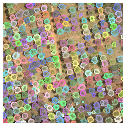
This research paper presents a new computer vision technique for automatically detecting individual trees in urban environments using high-resolution aerial photographs. The researchers developed a deep learning model, specifically a convolutional neural network, that can analyze the aerial images and identify the precise locations of trees.
The model outputs a "confidence map" that highlights the areas where it believes trees are located. The researchers then use a peak-finding algorithm to pinpoint the exact positions of individual trees from this confidence map. This allows the method to provide comprehensive spatial coverage, detecting trees in both public and private spaces across large urban areas.
To thoroughly test their approach, the researchers compiled a new dataset of over 1,500 aerial images with nearly 100,000 hand-annotated tree locations, spanning eight different cities, six climate zones, and three image capture years. They trained their model on data from Southern California and achieved strong performance, with 73.6% precision and 73.3% recall on the test set from that region. When applied to other California regions and image capture dates, the model maintained similar precision but had slightly lower recall.
Using this trained model, the researchers were able to generate a comprehensive map of the urban forest across the entire state of California. From this, they estimated the total number of urban trees in California to be around 43.5 million. This demonstrates the potential for deep learning techniques to support large-scale urban forestry studies that were not feasible with previous methods.
Technical Explanation
The core of the researchers' approach is a convolutional neural network that takes high-resolution multispectral aerial imagery as input and outputs a confidence map indicating the locations of individual trees. This confidence map is then processed using a peak finding algorithm to precisely localize the trees.
The researchers trained and evaluated their model using a new dataset of over 1,500 aerial images covering eight cities across California. This dataset includes almost 100,000 manually annotated tree locations, spanning a range of urban environments, climate zones, and image capture years. The researchers note that this is one of the largest and most diverse datasets of its kind, making it well-suited for training and evaluating tree detection models.
When trained on data from Southern California, the researchers' model achieved a precision of 73.6% and a recall of 73.3% on the test set from that region. They observed similar precision but slightly lower recall when applying the model to other climate zones and image capture dates within California. The researchers attribute this to potential differences in tree species, growth patterns, and imaging conditions across the diverse urban environments.
By applying their trained model across the entire state of California, the researchers were able to generate a comprehensive map of the urban forest and estimate the total number of urban trees to be approximately 43.5 million. This large-scale analysis would not have been feasible using traditional manual tree counting or rule-based computer vision methods.
Critical Analysis
The researchers acknowledge several limitations and avenues for future work. First, while the model performed well on the test set, there is still room for improvement in both precision and recall. The researchers suggest that incorporating additional data sources, such as LiDAR or street-level imagery, could help refine the model's performance.
Additionally, the researchers note that their current dataset, while large and diverse, may not fully capture the full range of urban environments and tree types found across the United States or globally. Further expanding the dataset to include more geographic regions and tree species could help the model generalize even better.
Finally, the researchers highlight the need for continued validation and real-world deployment of their method. While the results are promising, the model should be thoroughly tested in operational settings to ensure its reliability and scalability for practical urban forestry applications.
Conclusion
This research presents a novel deep learning-based approach for the large-scale detection of individual trees in urban environments using high-resolution aerial imagery. The thorough evaluation and impressive results, including the estimation of 43.5 million urban trees across California, demonstrate the potential of this technique to support comprehensive urban forestry studies at unprecedented scales.
By automating the process of tree detection and mapping, this method could revolutionize how urban planners, ecologists, and policymakers understand and manage urban forests. The insights gained from such large-scale analyses could inform critical decisions related to urban greening, climate change mitigation, and community wellbeing.
Overall, this work represents an important step forward in the application of advanced computer vision techniques to address complex real-world challenges in urban environmental management and sustainability.
This summary was produced with help from an AI and may contain inaccuracies - check out the links to read the original source documents!
Related Papers
🔎
0
Individual Tree Detection in Large-Scale Urban Environments using High-Resolution Multispectral Imagery
Jonathan Ventura, Camille Pawlak, Milo Honsberger, Cameron Gonsalves, Julian Rice, Natalie L. R. Love, Skyler Han, Viet Nguyen, Keilana Sugano, Jacqueline Doremus, G. Andrew Fricker, Jenn Yost, Matt Ritter
We introduce a novel deep learning method for detection of individual trees in urban environments using high-resolution multispectral aerial imagery. We use a convolutional neural network to regress a confidence map indicating the locations of individual trees, which are localized using a peak finding algorithm. Our method provides complete spatial coverage by detecting trees in both public and private spaces, and can scale to very large areas. We performed a thorough evaluation of our method, supported by a new dataset of over 1,500 images and almost 100,000 tree annotations, covering eight cities, six climate zones, and three image capture years. We trained our model on data from Southern California, and achieved a precision of 73.6% and recall of 73.3% using test data from this region. We generally observed similar precision and slightly lower recall when extrapolating to other California climate zones and image capture dates. We used our method to produce a map of trees in the entire urban forest of California, and estimated the total number of urban trees in California to be about 43.5 million. Our study indicates the potential for deep learning methods to support future urban forestry studies at unprecedented scales.
Read more7/4/2024
🏷️
0
Tree species classification at the pixel-level using deep learning and multispectral time series in an imbalanced context
Florian Mouret (CESBIO, UO), David Morin (CESBIO), Milena Planells (CESBIO), C'ecile Vincent-Barbaroux
This paper investigates tree species classification using Sentinel-2 multispectral satellite image time-series. Despite their critical importance for many applications, such maps are often unavailable, outdated, or inaccurate for large areas. The interest of using remote sensing time series to produce these maps has been highlighted in many studies. However, many methods proposed in the literature still rely on a standard classification algorithm, usually the Random Forest (RF) algorithm with vegetation indices. This study shows that the use of deep learning models can lead to a significant improvement in classification results, especially in an imbalanced context where the RF algorithm tends to predict towards the majority class. In our use case in the center of France with 10 tree species, we obtain an overall accuracy (OA) around 95% and a F1-macro score around 80% using three different benchmark deep learning architectures. In contrast, using the RF algorithm yields an OA of 93% and an F1 of 60%, indicating that the minority classes are not classified with sufficient accuracy. Therefore, the proposed framework is a strong baseline that can be easily implemented in most scenarios, even with a limited amount of reference data. Our results highlight that standard multilayer perceptron can be competitive with batch normalization and a sufficient amount of parameters. Other architectures (convolutional or attention-based) can also achieve strong results when tuned properly. Furthermore, our results show that DL models are naturally robust to imbalanced data, although similar results can be obtained using dedicated techniques.
Read more8/20/2024

0
Mining Field Data for Tree Species Recognition at Scale
Dimitri Gominski, Daniel Ortiz-Gonzalo, Martin Brandt, Maurice Mugabowindekwe, Rasmus Fensholt
Individual tree species labels are particularly hard to acquire due to the expert knowledge needed and the limitations of photointerpretation. Here, we present a methodology to automatically mine species labels from public forest inventory data, using available pretrained tree detection models. We identify tree instances in aerial imagery and match them with field data with close to zero human involvement. We conduct a series of experiments on the resulting dataset, and show a beneficial effect when adding noisy or even unlabeled data points, highlighting a strong potential for large-scale individual species mapping.
Read more8/29/2024
0
OAM-TCD: A globally diverse dataset of high-resolution tree cover maps
Josh Veitch-Michaelis, Andrew Cottam, Daniella Schweizer, Eben N. Broadbent, David Dao, Ce Zhang, Angelica Almeyda Zambrano, Simeon Max
Accurately quantifying tree cover is an important metric for ecosystem monitoring and for assessing progress in restored sites. Recent works have shown that deep learning-based segmentation algorithms are capable of accurately mapping trees at country and continental scales using high-resolution aerial and satellite imagery. Mapping at high (ideally sub-meter) resolution is necessary to identify individual trees, however there are few open-access datasets containing instance level annotations and those that exist are small or not geographically diverse. We present a novel open-access dataset for individual tree crown delineation (TCD) in high-resolution aerial imagery sourced from OpenAerialMap (OAM). Our dataset, OAM-TCD, comprises 5072 2048x2048 px images at 10 cm/px resolution with associated human-labeled instance masks for over 280k individual and 56k groups of trees. By sampling imagery from around the world, we are able to better capture the diversity and morphology of trees in different terrestrial biomes and in both urban and natural environments. Using our dataset, we train reference instance and semantic segmentation models that compare favorably to existing state-of-the-art models. We assess performance through k-fold cross-validation and comparison with existing datasets; additionally we demonstrate compelling results on independent aerial imagery captured over Switzerland and compare to municipal tree inventories and LIDAR-derived canopy maps in the city of Zurich. Our dataset, models and training/benchmark code are publicly released under permissive open-source licenses: Creative Commons (majority CC BY 4.0), and Apache 2.0 respectively.
Read more7/17/2024