Pixel-wise Agricultural Image Time Series Classification: Comparisons and a Deformable Prototype-based Approach

0
🖼️
Sign in to get full access
Overview
- Satellite imagery is becoming increasingly high-resolution, enabling better monitoring of agricultural activities.
- Current methods for crop segmentation in satellite image time series (SITS) data either require annotated data or are heavily engineered.
- This paper presents and compares supervised and unsupervised pixel-wise segmentation methods for SITS, including an approach to add invariance to spectral deformations and temporal shifts.
Plain English Explanation
Satellites can now take pictures of the Earth in very high detail and with a high frequency. This is useful for monitoring agriculture, as it can help address environmental and economic challenges. However, the current methods for identifying different crops in these satellite images either need a lot of labeled data or require significant customization to work without supervision.
This research paper introduces and tests different approaches for automatically identifying crops in satellite image time series (SITS) data, both with and without needing labeled examples. One of the methods they propose adds some special properties to a classic unsupervised machine learning technique, making it more robust to variations in the images and changes over time.
The researchers find that this simple but powerful method performs best when there is limited labeled data available, and significantly improves the state-of-the-art for unsupervised classification of agricultural time series on several recently released SITS datasets.
Technical Explanation
The paper presents and evaluates both supervised and unsupervised pixel-wise segmentation methods for satellite image time series (SITS) data. One of the key innovations is an approach to add invariance to spectral deformations and temporal shifts to classical prototype-based methods like K-means and Nearest Centroid Classifier (NCC).
The researchers study different levels of supervision, from fully supervised to completely unsupervised. They find that their simple yet highly interpretable method achieves the best performance in the low data regime and significantly improves the state-of-the-art for unsupervised classification of agricultural time series on four recent SITS datasets.
Critical Analysis
The paper acknowledges that the proposed method, while effective, is still limited to agricultural applications and may not generalize well to other domains. Additionally, the experiments were conducted on relatively small datasets, and the performance on larger, more diverse datasets remains to be explored.
It would also be interesting to see how the method compares to more advanced deep learning techniques for SITS analysis, which have shown promising results in recent years. Incorporating additional data sources, such as weather or soil information, could also potentially further improve the segmentation accuracy.
Conclusion
This research demonstrates the potential of leveraging high-resolution satellite imagery for agricultural monitoring, a key capability for addressing environmental and economic challenges. The proposed method provides a simple yet effective approach for crop segmentation in SITS data, particularly when labeled data is scarce. While there are still opportunities for further improvements, this work represents an important step forward in making the most of our growing Earth observation capabilities.
This summary was produced with help from an AI and may contain inaccuracies - check out the links to read the original source documents!
Related Papers
🖼️
0
Pixel-wise Agricultural Image Time Series Classification: Comparisons and a Deformable Prototype-based Approach
Elliot Vincent, Jean Ponce, Mathieu Aubry
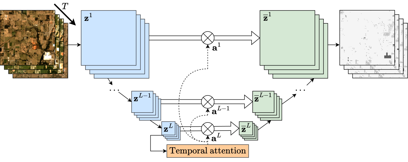
Improvements in Earth observation by satellites allow for imagery of ever higher temporal and spatial resolution. Leveraging this data for agricultural monitoring is key for addressing environmental and economic challenges. Current methods for crop segmentation using temporal data either rely on annotated data or are heavily engineered to compensate the lack of supervision. In this paper, we present and compare datasets and methods for both supervised and unsupervised pixel-wise segmentation of satellite image time series (SITS). We also introduce an approach to add invariance to spectral deformations and temporal shifts to classical prototype-based methods such as K-means and Nearest Centroid Classifier (NCC). We study different levels of supervision and show this simple and highly interpretable method achieves the best performance in the low data regime and significantly improves the state of the art for unsupervised classification of agricultural time series on four recent SITS datasets.
Read more7/15/2024

0
S4: Self-Supervised Sensing Across the Spectrum
Jayanth Shenoy, Xingjian Davis Zhang, Shlok Mehrotra, Bill Tao, Rem Yang, Han Zhao, Deepak Vasisht
Satellite image time series (SITS) segmentation is crucial for many applications like environmental monitoring, land cover mapping and agricultural crop type classification. However, training models for SITS segmentation remains a challenging task due to the lack of abundant training data, which requires fine grained annotation. We propose S4 a new self-supervised pre-training approach that significantly reduces the requirement for labeled training data by utilizing two new insights: (a) Satellites capture images in different parts of the spectrum such as radio frequencies, and visible frequencies. (b) Satellite imagery is geo-registered allowing for fine-grained spatial alignment. We use these insights to formulate pre-training tasks in S4. We also curate m2s2-SITS, a large-scale dataset of unlabeled, spatially-aligned, multi-modal and geographic specific SITS that serves as representative pre-training data for S4. Finally, we evaluate S4 on multiple SITS segmentation datasets and demonstrate its efficacy against competing baselines while using limited labeled data.
Read more6/28/2024
🤿
0
Deep Learning for Satellite Image Time Series Analysis: A Review
Lynn Miller, Charlotte Pelletier, Geoffrey I. Webb
Earth observation (EO) satellite missions have been providing detailed images about the state of the Earth and its land cover for over 50 years. Long term missions, such as NASA's Landsat, Terra, and Aqua satellites, and more recently, the ESA's Sentinel missions, record images of the entire world every few days. Although single images provide point-in-time data, repeated images of the same area, or satellite image time series (SITS) provide information about the changing state of vegetation and land use. These SITS are useful for modeling dynamic processes and seasonal changes such as plant phenology. They have potential benefits for many aspects of land and natural resource management, including applications in agricultural, forest, water, and disaster management, urban planning, and mining. However, the resulting satellite image time series (SITS) are complex, incorporating information from the temporal, spatial, and spectral dimensions. Therefore, deep learning methods are often deployed as they can analyze these complex relationships. This review presents a summary of the state-of-the-art methods of modelling environmental, agricultural, and other Earth observation variables from SITS data using deep learning methods. We aim to provide a resource for remote sensing experts interested in using deep learning techniques to enhance Earth observation models with temporal information.
Read more4/12/2024
0
Satellite Image Time Series Semantic Change Detection: Novel Architecture and Analysis of Domain Shift
Elliot Vincent, Jean Ponce, Mathieu Aubry
Satellite imagery plays a crucial role in monitoring changes happening on Earth's surface and aiding in climate analysis, ecosystem assessment, and disaster response. In this paper, we tackle semantic change detection with satellite image time series (SITS-SCD) which encompasses both change detection and semantic segmentation tasks. We propose a new architecture that improves over the state of the art, scales better with the number of parameters, and leverages long-term temporal information. However, for practical use cases, models need to adapt to spatial and temporal shifts, which remains a challenge. We investigate the impact of temporal and spatial shifts separately on global, multi-year SITS datasets using DynamicEarthNet and MUDS. We show that the spatial domain shift represents the most complex setting and that the impact of temporal shift on performance is more pronounced on change detection than on semantic segmentation, highlighting that it is a specific issue deserving further attention.
Read more7/11/2024