Planning and Perception for Unmanned Aerial Vehicles in Object and Environmental Monitoring

0

Sign in to get full access
Overview
- This paper discusses the use of unmanned aerial vehicles (UAVs) for distributed learning and environmental monitoring in rural areas.
- It also explores the challenges of ensuring UAV safety through vision-only real-time perception and planning.
- The paper covers various computer vision tasks relevant to intelligent aerospace missions, such as sensor planning for a single-axis gimbaled camera and UAV-vehicle collaborative perception for 3D reconstruction.
Plain English Explanation
The paper explores how UAVs can be used to help monitor the environment and gather data in remote, rural areas. This could be helpful for things like tracking the health of crops or wildlife. However, there are also challenges in making sure the UAVs can navigate safely and effectively, using only their cameras to understand their surroundings in real-time.
The paper also looks at different computer vision techniques that could be useful for UAVs and other aerospace applications. For example, it discusses how a UAV with a camera that can pan and tilt could be used to gather more detailed information about its environment. It also explores how UAVs could work together with ground vehicles to create 3D maps of an area.
Overall, the research in this paper aims to find ways that UAVs and computer vision can be used to gather important data and monitor the environment, especially in hard-to-reach places. However, ensuring the safety and reliability of these UAV systems is a key challenge that the researchers are working to address.
Technical Explanation
The paper presents several research directions related to the use of unmanned aerial vehicles (UAVs) for distributed learning and environmental monitoring in rural areas. It explores the challenges of ensuring UAV safety through vision-only real-time perception and planning.
The paper also covers various computer vision tasks relevant to intelligent aerospace missions, such as informative sensor planning for a single-axis gimbaled camera and UAV-vehicle collaborative perception for 3D reconstruction. Additionally, it provides an overview of computer vision tasks for intelligent aerospace missions.
The researchers investigate how UAVs can be leveraged for distributed learning and environmental monitoring in rural areas, addressing the need for data collection and analysis in remote locations.
Critical Analysis
The paper presents a comprehensive overview of the challenges and opportunities in using UAVs for environmental monitoring and distributed learning tasks. However, the authors do acknowledge several limitations and areas for further research.
One key limitation is the reliance on vision-only perception for UAV safety and navigation. While the authors explore techniques to address this, there may be additional challenges in complex or rapidly changing environments that require more robust sensor fusion approaches.
Additionally, the collaborative perception work between UAVs and ground vehicles could be further expanded to include other types of platforms, such as satellites or ground robots, to create more complete and reliable 3D reconstructions.
The paper would also benefit from a more in-depth discussion of the potential privacy and security concerns associated with widespread UAV deployment, as well as strategies to mitigate these issues.
Overall, the research presented in this paper represents an important step forward in leveraging UAVs and computer vision for environmental monitoring and data collection. However, continued advancements in areas like sensor fusion, multi-agent coordination, and responsible deployment will be crucial to realizing the full potential of these technologies.
Conclusion
This paper explores the use of unmanned aerial vehicles (UAVs) for distributed learning and environmental monitoring in rural areas, as well as the challenges of ensuring UAV safety through vision-only real-time perception and planning. It also covers various computer vision tasks relevant to intelligent aerospace missions, such as sensor planning and UAV-vehicle collaborative perception.
The research presented in this paper represents a significant step forward in leveraging UAVs and computer vision to gather important data and monitor the environment, especially in hard-to-reach places. However, the authors acknowledge several limitations and areas for further research, such as the need for more robust sensor fusion approaches and strategies to address privacy and security concerns.
Overall, the findings in this paper have the potential to drive important advancements in the field of intelligent aerospace systems and contribute to our understanding of how these technologies can be responsibly deployed to benefit society.
This summary was produced with help from an AI and may contain inaccuracies - check out the links to read the original source documents!
Related Papers
0
Planning and Perception for Unmanned Aerial Vehicles in Object and Environmental Monitoring
Harnaik Dhami
Unmanned Aerial Vehicles (UAVs) equipped with high-resolution sensors enable extensive data collection from previously inaccessible areas at a remarkable spatio-temporal scale, promising to revolutionize fields such as precision agriculture and infrastructure inspection. To fully exploit their potential, developing autonomy algorithms for planning and perception is crucial. This dissertation focuses on developing planning and perception algorithms tailored to UAVs used in monitoring applications. In the first part, we address object monitoring and its associated planning challenges. Object monitoring involves continuous observation, tracking, and analysis of specific objects. We tackle the problem of visual reconstruction where the goal is to maximize visual coverage of an object in an unknown environment efficiently. Leveraging shape prediction deep learning models, we optimize planning for quick information gathering. Extending this to multi-UAV systems, we create efficient paths around objects based on reconstructed 3D models, crucial for close-up inspections aimed at detecting changes. Next, we explore inspection scenarios where an object has changed or no prior information is available, focusing on infrastructure inspection. We validate our planning algorithms through real-world experiments and high-fidelity simulations, integrating defect detection seamlessly into the process. In the second part, we shift focus to monitoring entire environments, distinct from object-specific monitoring. Here, the goal is to maximize coverage to understand spatio-temporal changes. We investigate slow-changing environments like vegetative growth estimation and fast-changing environments such as wildfire management. For wildfires, we employ informative path planning to validate and localize fires early, utilizing LSTM networks for enhanced early detection.
Read more7/19/2024
0
UAV-assisted Distributed Learning for Environmental Monitoring in Rural Environments
Vukan Ninkovic, Dejan Vukobratovic, Dragisa Miskovic
Distributed learning and inference algorithms have become indispensable for IoT systems, offering benefits such as workload alleviation, data privacy preservation, and reduced latency. This paper introduces an innovative approach that utilizes unmanned aerial vehicles (UAVs) as a coverage extension relay for IoT environmental monitoring in rural areas. Our method integrates a split learning (SL) strategy between edge devices, a UAV and a server to enhance adaptability and performance of inference mechanisms. By employing UAVs as a relay and by incorporating SL, we address connectivity and resource constraints for applications of learning in IoT in remote settings. Our system model accounts for diverse channel conditions to determine the most suitable transmission strategy for optimal system behaviour. Through simulation analysis, the proposed approach demonstrates its robustness and adaptability, even excelling under adverse channel conditions. Integrating UAV relaying and the SL paradigm offers significant flexibility to the server, enabling adaptive strategies that consider various trade-offs beyond simply minimizing overall inference quality.
Read more7/4/2024
0
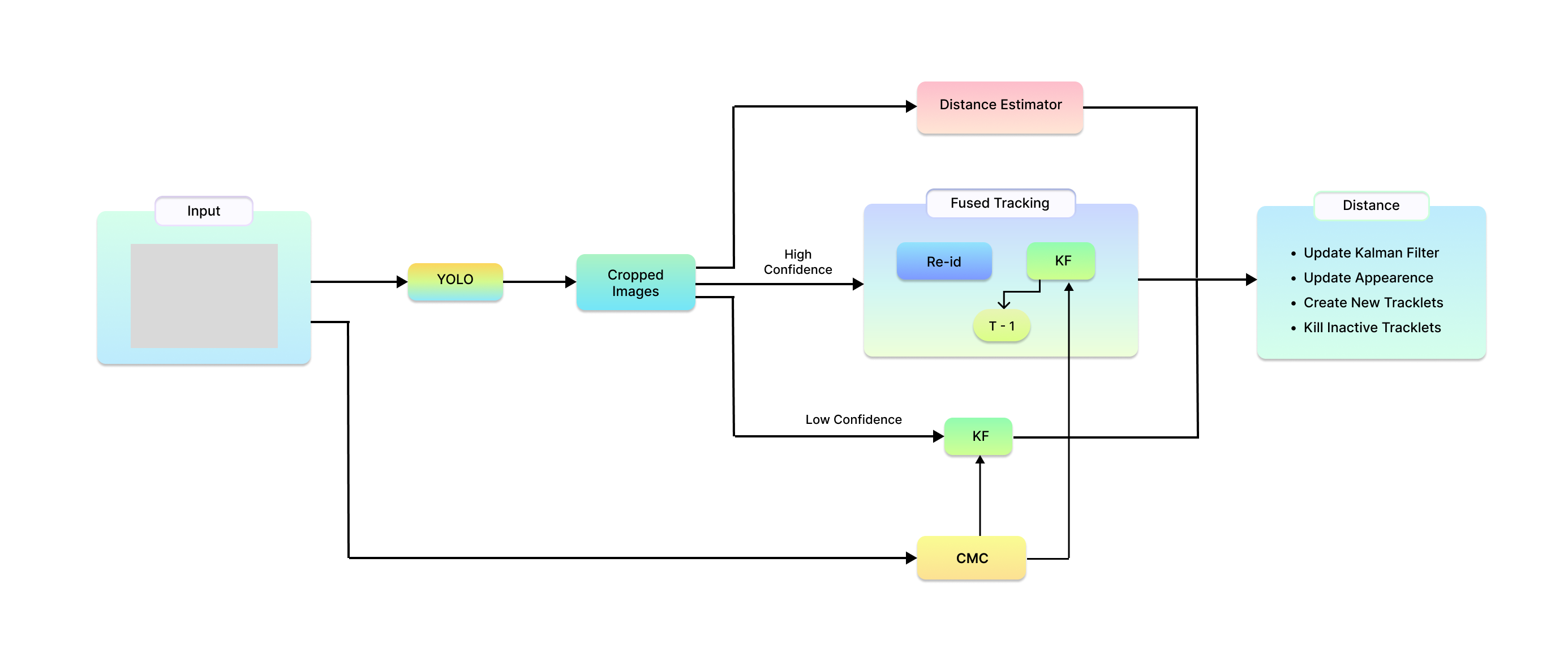
Ensuring UAV Safety: A Vision-only and Real-time Framework for Collision Avoidance Through Object Detection, Tracking, and Distance Estimation
Vasileios Karampinis, Anastasios Arsenos, Orfeas Filippopoulos, Evangelos Petrongonas, Christos Skliros, Dimitrios Kollias, Stefanos Kollias, Athanasios Voulodimos
In the last twenty years, unmanned aerial vehicles (UAVs) have garnered growing interest due to their expanding applications in both military and civilian domains. Detecting non-cooperative aerial vehicles with efficiency and estimating collisions accurately are pivotal for achieving fully autonomous aircraft and facilitating Advanced Air Mobility (AAM). This paper presents a deep-learning framework that utilizes optical sensors for the detection, tracking, and distance estimation of non-cooperative aerial vehicles. In implementing this comprehensive sensing framework, the availability of depth information is essential for enabling autonomous aerial vehicles to perceive and navigate around obstacles. In this work, we propose a method for estimating the distance information of a detected aerial object in real time using only the input of a monocular camera. In order to train our deep learning components for the object detection, tracking and depth estimation tasks we utilize the Amazon Airborne Object Tracking (AOT) Dataset. In contrast to previous approaches that integrate the depth estimation module into the object detector, our method formulates the problem as image-to-image translation. We employ a separate lightweight encoder-decoder network for efficient and robust depth estimation. In a nutshell, the object detection module identifies and localizes obstacles, conveying this information to both the tracking module for monitoring obstacle movement and the depth estimation module for calculating distances. Our approach is evaluated on the Airborne Object Tracking (AOT) dataset which is the largest (to the best of our knowledge) air-to-air airborne object dataset.
Read more5/17/2024

0
Computer vision tasks for intelligent aerospace missions: An overview
Huilin Chen, Qiyu Sun, Fangfei Li, Yang Tang
Computer vision tasks are crucial for aerospace missions as they help spacecraft to understand and interpret the space environment, such as estimating position and orientation, reconstructing 3D models, and recognizing objects, which have been extensively studied to successfully carry out the missions. However, traditional methods like Kalman Filtering, Structure from Motion, and Multi-View Stereo are not robust enough to handle harsh conditions, leading to unreliable results. In recent years, deep learning (DL)-based perception technologies have shown great potential and outperformed traditional methods, especially in terms of their robustness to changing environments. To further advance DL-based aerospace perception, various frameworks, datasets, and strategies have been proposed, indicating significant potential for future applications. In this survey, we aim to explore the promising techniques used in perception tasks and emphasize the importance of DL-based aerospace perception. We begin by providing an overview of aerospace perception, including classical space programs developed in recent years, commonly used sensors, and traditional perception methods. Subsequently, we delve into three fundamental perception tasks in aerospace missions: pose estimation, 3D reconstruction, and recognition, as they are basic and crucial for subsequent decision-making and control. Finally, we discuss the limitations and possibilities in current research and provide an outlook on future developments, including the challenges of working with limited datasets, the need for improved algorithms, and the potential benefits of multi-source information fusion.
Read more7/10/2024