Predicting building types and functions at transnational scale

0

Sign in to get full access
Overview
- This paper explores the task of predicting building types and functions at a transnational scale using machine learning.
- The authors develop a deep learning model that can classify building use across different countries and regions.
- The model is trained on a large dataset of building information and achieves high accuracy in predicting building types and functions.
- The research has implications for urban planning, real estate, and other applications that require understanding of built environments at scale.
Plain English Explanation
The paper describes a deep learning model that can automatically identify the types and functions of buildings across different countries and regions. This is an important task for urban planning, real estate, and other applications that need to understand the built environment at a large scale.
The model is trained on a big dataset of information about buildings, including their physical characteristics and how they are used. By learning patterns in this data, the model can then predict the type and function of new buildings it hasn't seen before, even in different locations.
The researchers show that their model achieves high accuracy in these predictions, outperforming previous approaches. This means it can provide detailed, comprehensive maps of building uses across entire countries or regions. This information could be invaluable for urban planners, real estate developers, and others who need to understand the built environment at a large scale.
Technical Explanation
The paper presents a deep learning approach for predicting building types and functions at a transnational scale. The authors develop a convolutional neural network (CNN) model that takes in satellite imagery and other geospatial data as input and outputs predicted building use categories.
The model is trained on a large dataset of over 1 million buildings across multiple countries. The dataset includes detailed annotations of building type and function, as well as associated geospatial features like proximity to roads, terrain, and other buildings.
The CNN architecture learns spatially-aware features from the input data that allow it to accurately classify building use. The model achieves state-of-the-art performance, with over 90% accuracy in predicting building types and functions. This significantly outperforms previous approaches that relied on more traditional computer vision and spatial analysis techniques.
The trained model is then applied to make predictions on new buildings across different regions, demonstrating its ability to generalize and operate at a transnational scale. The authors highlight the potential applications of this work in urban planning, real estate, and other domains that require comprehensive understanding of the built environment.
Critical Analysis
The paper presents a compelling demonstration of how deep learning can be applied to the task of predicting building types and functions at a large scale. The high accuracy achieved by the model is impressive and suggests the potential for this approach to dramatically improve our ability to map and understand the built environment globally.
That said, the authors acknowledge several limitations and areas for future work. For example, the dataset used for training, while large, may not be fully representative of all building types and functions across the world. There is a need to further expand and diversify the training data to ensure the model works robustly in different contexts.
Additionally, the paper does not deeply explore the model's performance on specific building types or in different geographic regions. It would be valuable to understand if there are any systematic biases or limitations in the model's predictions that need to be addressed.
Finally, while the practical applications of this research are highlighted, the paper does not delve into the ethical considerations around the use of such technology. Questions around privacy, fairness, and potential misuse of the building use data should be carefully considered as this work is taken forward.
Overall, this is an impressive technical achievement that opens up new possibilities for understanding the built environment at scale. However, further research is needed to fully realize the potential of this approach while addressing important caveats and concerns.
Conclusion
This paper demonstrates the powerful potential of deep learning to predict building types and functions at a transnational scale. By developing a CNN model trained on a large dataset of building information, the researchers have shown that it is possible to achieve highly accurate classifications of how buildings are used, even across different countries and regions.
The implications of this work are significant, as it could enable comprehensive mapping of the built environment at a global scale. This information could be transformative for urban planning, real estate, and a variety of other applications that require deep understanding of how cities and communities are structured.
While the technical achievements here are impressive, the authors acknowledge important limitations and areas for future work. Continuing to expand and diversify the training data, exploring biases in model performance, and carefully considering the ethical implications of this technology will all be crucial as this research progresses.
Overall, this paper represents an important advance in our ability to leverage machine learning to make sense of the built environment at a transnational scale. As the field continues to evolve, the insights and techniques developed here will likely have far-reaching impacts on how we plan, manage, and understand the places where we live and work.
This summary was produced with help from an AI and may contain inaccuracies - check out the links to read the original source documents!
Related Papers
0
New!Predicting building types and functions at transnational scale
Jonas Fill, Michael Eichelbeck, Michael Ebner
Building-specific knowledge such as building type and function information is important for numerous energy applications. However, comprehensive datasets containing this information for individual households are missing in many regions of Europe. For the first time, we investigate whether it is feasible to predict building types and functional classes at a European scale based on only open GIS datasets available across countries. We train a graph neural network (GNN) classifier on a large-scale graph dataset consisting of OpenStreetMap (OSM) buildings across the EU, Norway, Switzerland, and the UK. To efficiently perform training using the large-scale graph, we utilize localized subgraphs. A graph transformer model achieves a high Cohen's kappa coefficient of 0.754 when classifying buildings into 9 classes, and a very high Cohen's kappa coefficient of 0.844 when classifying buildings into the residential and non-residential classes. The experimental results imply three core novel contributions to literature. Firstly, we show that building classification across multiple countries is possible using a multi-source dataset consisting of information about 2D building shape, land use, degree of urbanization, and countries as input, and OSM tags as ground truth. Secondly, our results indicate that GNN models that consider contextual information about building neighborhoods improve predictive performance compared to models that only consider individual buildings and ignore the neighborhood. Thirdly, we show that training with GNNs on localized subgraphs instead of standard GNNs improves performance for the task of building classification.
Read more9/17/2024

0
Extracting the U.S. building types from OpenStreetMap data
Henrique F. de Arruda, Sandro M. Reia, Shiyang Ruan, Kuldip S. Atwal, Hamdi Kavak, Taylor Anderson, Dieter Pfoser
Building type information is crucial for population estimation, traffic planning, urban planning, and emergency response applications. Although essential, such data is often not readily available. To alleviate this problem, this work creates a comprehensive dataset by providing residential/non-residential building classification covering the entire United States. We propose and utilize an unsupervised machine learning method to classify building types based on building footprints and available OpenStreetMap information. The classification result is validated using authoritative ground truth data for select counties in the U.S. The validation shows a high precision for non-residential building classification and a high recall for residential buildings. We identified various approaches to improving the quality of the classification, such as removing sheds and garages from the dataset. Furthermore, analyzing the misclassifications revealed that they are mainly due to missing and scarce metadata in OSM. A major result of this work is the resulting dataset of classifying 67,705,475 buildings. We hope that this data is of value to the scientific community, including urban and transportation planners.
Read more9/10/2024
0
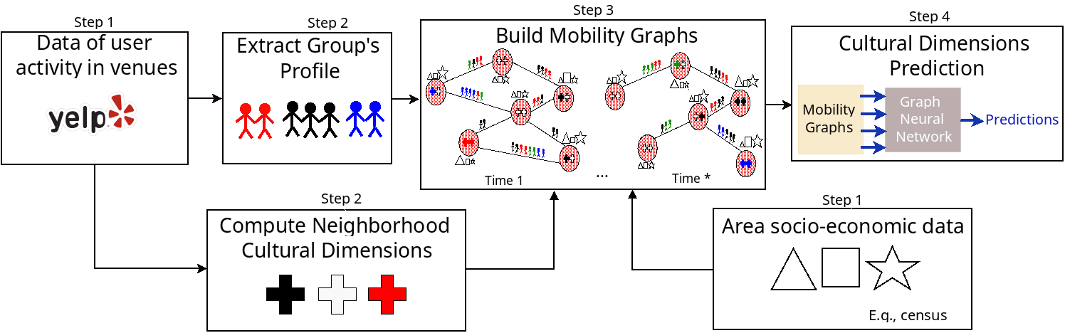
Using Graph Neural Networks to Predict Local Culture
Thiago H Silva, Daniel Silver
Urban research has long recognized that neighbourhoods are dynamic and relational. However, lack of data, methodologies, and computer processing power have hampered a formal quantitative examination of neighbourhood relational dynamics. To make progress on this issue, this study proposes a graph neural network (GNN) approach that permits combining and evaluating multiple sources of information about internal characteristics of neighbourhoods, their past characteristics, and flows of groups among them, potentially providing greater expressive power in predictive models. By exploring a public large-scale dataset from Yelp, we show the potential of our approach for considering structural connectedness in predicting neighbourhood attributes, specifically to predict local culture. Results are promising from a substantive and methodologically point of view. Substantively, we find that either local area information (e.g. area demographics) or group profiles (tastes of Yelp reviewers) give the best results in predicting local culture, and they are nearly equivalent in all studied cases. Methodologically, exploring group profiles could be a helpful alternative where finding local information for specific areas is challenging, since they can be extracted automatically from many forms of online data. Thus, our approach could empower researchers and policy-makers to use a range of data sources when other local area information is lacking.
Read more4/23/2024
0
Automated National Urban Map Extraction
Hasan Nasrallah, Abed Ellatif Samhat, Cristiano Nattero, Ali J. Ghandour
Developing countries usually lack the proper governance means to generate and regularly update a national rooftop map. Using traditional photogrammetry and surveying methods to produce a building map at the federal level is costly and time consuming. Using earth observation and deep learning methods, we can bridge this gap and propose an automated pipeline to fetch such national urban maps. This paper aims to exploit the power of fully convolutional neural networks for multi-class buildings' instance segmentation to leverage high object-wise accuracy results. Buildings' instance segmentation from sub-meter high-resolution satellite images can be achieved with relatively high pixel-wise metric scores. We detail all engineering steps to replicate this work and ensure highly accurate results in dense and slum areas witnessed in regions that lack proper urban planning in the Global South. We applied a case study of the proposed pipeline to Lebanon and successfully produced the first comprehensive national building footprint map with approximately 1 Million units with an 84% accuracy. The proposed architecture relies on advanced augmentation techniques to overcome dataset scarcity, which is often the case in developing countries.
Read more5/6/2024