RSBuilding: Towards General Remote Sensing Image Building Extraction and Change Detection with Foundation Model
2403.07564
0
0
Abstract
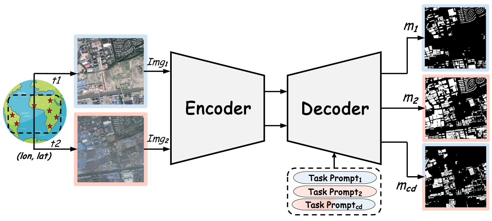
The intelligent interpretation of buildings plays a significant role in urban planning and management, macroeconomic analysis, population dynamics, etc. Remote sensing image building interpretation primarily encompasses building extraction and change detection. However, current methodologies often treat these two tasks as separate entities, thereby failing to leverage shared knowledge. Moreover, the complexity and diversity of remote sensing image scenes pose additional challenges, as most algorithms are designed to model individual small datasets, thus lacking cross-scene generalization. In this paper, we propose a comprehensive remote sensing image building understanding model, termed RSBuilding, developed from the perspective of the foundation model. RSBuilding is designed to enhance cross-scene generalization and task universality. Specifically, we extract image features based on the prior knowledge of the foundation model and devise a multi-level feature sampler to augment scale information. To unify task representation and integrate image spatiotemporal clues, we introduce a cross-attention decoder with task prompts. Addressing the current shortage of datasets that incorporate annotations for both tasks, we have developed a federated training strategy to facilitate smooth model convergence even when supervision for some tasks is missing, thereby bolstering the complementarity of different tasks. Our model was trained on a dataset comprising up to 245,000 images and validated on multiple building extraction and change detection datasets. The experimental results substantiate that RSBuilding can concurrently handle two structurally distinct tasks and exhibits robust zero-shot generalization capabilities.
Get summaries of the top AI research delivered straight to your inbox:
Overview
- Presents a new model called RSBuilding for building extraction and change detection from remote sensing images
- Leverages a foundation model trained on a large and diverse dataset to enable generalization to new environments and tasks
- Explores federated training approaches to improve model performance without compromising user privacy
Plain English Explanation
The paper introduces a new model called RSBuilding that can be used to extract buildings and detect changes in remote sensing images. Remote sensing images are captured by satellites or drones and can be used to monitor and analyze large areas of the Earth's surface.
The key innovation of RSBuilding is that it leverages a "foundation model" - a model that has been pre-trained on a large and diverse dataset. This allows the model to generalize well to new environments and tasks, rather than having to be trained from scratch every time. The paper also explores using federated learning, which enables multiple parties to collaborate on training the model without compromising user privacy.
The goal of RSBuilding is to make it easier and more efficient to extract information about buildings and track changes over time from remote sensing data. This could have important applications in urban planning, disaster response, and environmental monitoring, among other areas.
Technical Explanation
The paper presents the RSBuilding model, which builds on the success of foundation models in computer vision and natural language processing. The model is pre-trained on a large and diverse dataset of remote sensing images, enabling it to generalize well to new environments and tasks such as building extraction and change detection.
The authors also explore the use of federated learning to train the RSBuilding model, where multiple parties collaborate on the training process without sharing their raw data. This approach could help improve the model's performance while preserving user privacy, an important consideration for many remote sensing applications.
The paper describes the RSBuilding architecture, which consists of a backbone encoder network and task-specific decoder heads for building extraction and change detection. The model is evaluated on several benchmark datasets, demonstrating strong performance compared to existing approaches, including expedited building footprint extraction and automated urban mapping.
Critical Analysis
The paper makes a compelling case for the use of foundation models and federated learning in remote sensing applications. The results suggest that RSBuilding can achieve state-of-the-art performance on building extraction and change detection tasks, while the federated training approach helps to address privacy concerns.
However, the paper does not fully explore the limitations of the approach. For example, it is unclear how the model would perform on more complex or noisier remote sensing data, or how it would scale to larger geographic areas. Additionally, the authors do not discuss the computational and storage requirements of the foundation model, which could be a significant practical consideration for some applications.
Further research is also needed to better understand the tradeoffs between model performance, privacy, and computational efficiency in the federated learning setup. Panoptic perception and other fine-grained analysis tasks could also be an interesting area to explore with the RSBuilding framework.
Conclusion
The RSBuilding model represents an important step towards more general and scalable remote sensing analysis capabilities. By leveraging foundation models and federated learning, the authors have demonstrated the potential to extract valuable information from remote sensing data while addressing key practical challenges around privacy and computational efficiency.
The results suggest that this approach could have significant implications for a wide range of applications, from urban planning and disaster response to environmental monitoring and resource management. As the field of remote sensing continues to evolve, the insights and techniques presented in this paper are likely to become increasingly important for unlocking the full potential of this powerful data source.
This summary was produced with help from an AI and may contain inaccuracies - check out the links to read the original source documents!
Related Papers
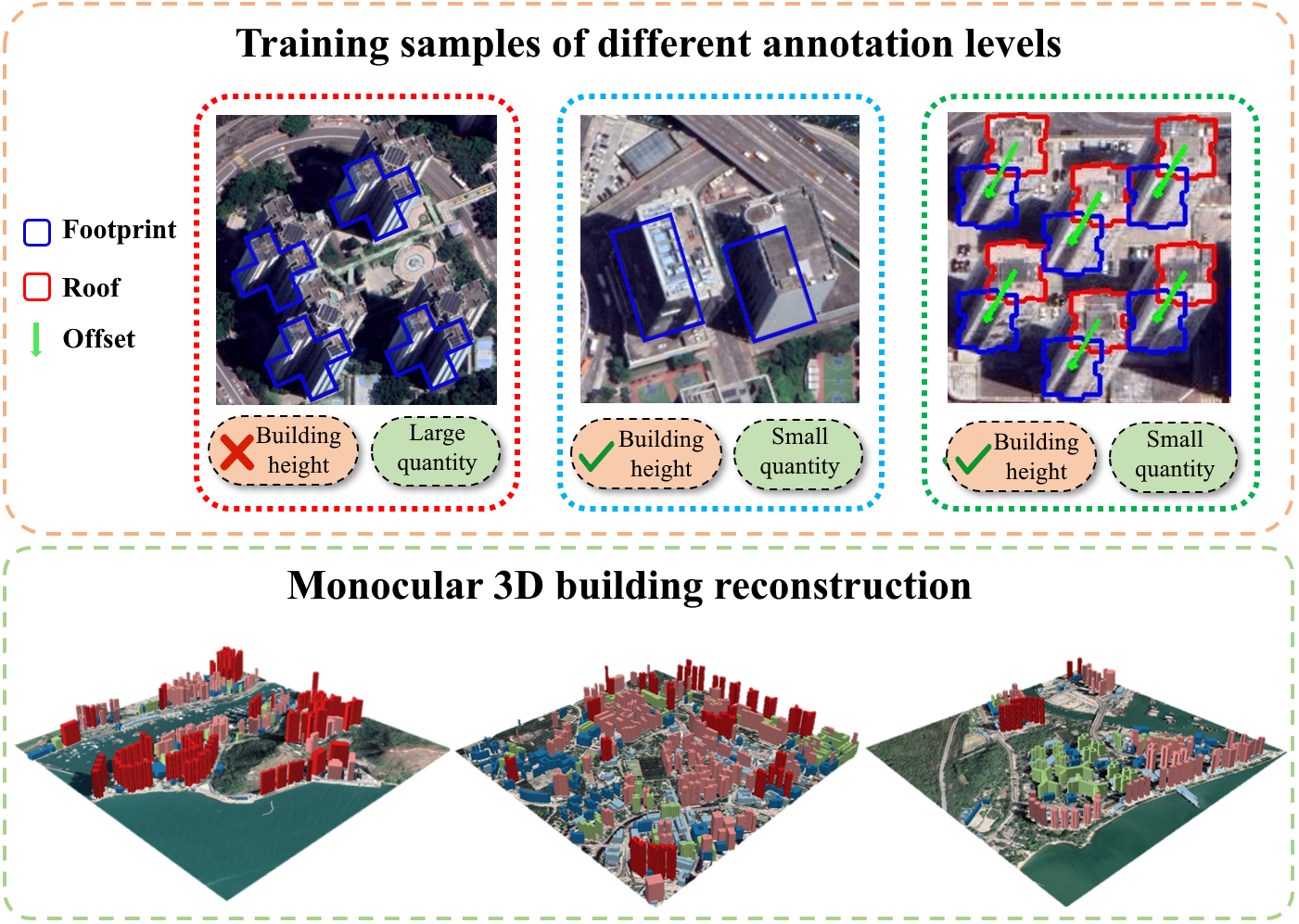
3D Building Reconstruction from Monocular Remote Sensing Images with Multi-level Supervisions
Weijia Li, Haote Yang, Zhenghao Hu, Juepeng Zheng, Gui-Song Xia, Conghui He
0
0
3D building reconstruction from monocular remote sensing images is an important and challenging research problem that has received increasing attention in recent years, owing to its low cost of data acquisition and availability for large-scale applications. However, existing methods rely on expensive 3D-annotated samples for fully-supervised training, restricting their application to large-scale cross-city scenarios. In this work, we propose MLS-BRN, a multi-level supervised building reconstruction network that can flexibly utilize training samples with different annotation levels to achieve better reconstruction results in an end-to-end manner. To alleviate the demand on full 3D supervision, we design two new modules, Pseudo Building Bbox Calculator and Roof-Offset guided Footprint Extractor, as well as new tasks and training strategies for different types of samples. Experimental results on several public and new datasets demonstrate that our proposed MLS-BRN achieves competitive performance using much fewer 3D-annotated samples, and significantly improves the footprint extraction and 3D reconstruction performance compared with current state-of-the-art. The code and datasets of this work will be released at https://github.com/opendatalab/MLS-BRN.git.
4/9/2024
⛏️
Building-road Collaborative Extraction from Remotely Sensed Images via Cross-Interaction
Haonan Guo, Xin Su, Chen Wu, Bo Du, Liangpei Zhang
0
0
Buildings are the basic carrier of social production and human life; roads are the links that interconnect social networks. Building and road information has important application value in the frontier fields of regional coordinated development, disaster prevention, auto-driving, etc. Mapping buildings and roads from very high-resolution (VHR) remote sensing images have become a hot research topic. However, the existing methods often ignore the strong spatial correlation between roads and buildings and extract them in isolation. To fully utilize the complementary advantages between buildings and roads, we propose a building-road collaborative extraction method based on multi-task and cross-scale feature interaction to improve the accuracy of both tasks in a complementary way. A multi-task interaction module is proposed to interact information across tasks and preserve the unique information of each task, which tackle the seesaw phenomenon in multitask learning. By considering the variation in appearance and structure between buildings and roads, a cross-scale interaction module is designed to automatically learn the optimal reception field for different tasks. Compared with many existing methods that train each task individually, the proposed collaborative extraction method can utilize the complementary advantages between buildings and roads by the proposed inter-task and inter-scale feature interactions, and automatically select the optimal reception field for different tasks. Experiments on a wide range of urban and rural scenarios show that the proposed algorithm can achieve building-road extraction with outstanding performance and efficiency.
4/11/2024
📊
Identifying every building's function in large-scale urban areas with multi-modality remote-sensing data
Zhuohong Li, Wei He, Jiepan Li, Hongyan Zhang
0
0
Buildings, as fundamental man-made structures in urban environments, serve as crucial indicators for understanding various city function zones. Rapid urbanization has raised an urgent need for efficiently surveying building footprints and functions. In this study, we proposed a semi-supervised framework to identify every building's function in large-scale urban areas with multi-modality remote-sensing data. In detail, optical images, building height, and nighttime-light data are collected to describe the morphological attributes of buildings. Then, the area of interest (AOI) and building masks from the volunteered geographic information (VGI) data are collected to form sparsely labeled samples. Furthermore, the multi-modality data and weak labels are utilized to train a segmentation model with a semi-supervised strategy. Finally, results are evaluated by 20,000 validation points and statistical survey reports from the government. The evaluations reveal that the produced function maps achieve an OA of 82% and Kappa of 71% among 1,616,796 buildings in Shanghai, China. This study has the potential to support large-scale urban management and sustainable urban development. All collected data and produced maps are open access at https://github.com/LiZhuoHong/BuildingMap.
5/9/2024
📊
Estimate the building height at a 10-meter resolution based on Sentinel data
Xin Yan
0
0
Building height is an important indicator for scientific research and practical application. However, building height products with a high spatial resolution (10m) are still very scarce. To meet the needs of high-resolution building height estimation models, this study established a set of spatial-spectral-temporal feature databases, combining SAR data provided by Sentinel-1, optical data provided by Sentinel-2, and shape data provided by building footprints. The statistical indicators on the time scale are extracted to form a rich database of 160 features. This study combined with permutation feature importance, Shapley Additive Explanations, and Random Forest variable importance, and the final stable features are obtained through an expert scoring system. This study took 12 large, medium, and small cities in the United States as the training data. It used moving windows to aggregate the pixels to solve the impact of SAR image displacement and building shadows. This study built a building height model based on a random forest model and compared three model ensemble methods of bagging, boosting, and stacking. To evaluate the accuracy of the prediction results, this study collected Lidar data in the test area, and the evaluation results showed that its R-Square reached 0.78, which can prove that the building height can be obtained effectively. The fast production of high-resolution building height data can support large-scale scientific research and application in many fields.
5/3/2024