Scaling Efficient Masked Autoencoder Learning on Large Remote Sensing Dataset
2406.11933
0
0

Abstract
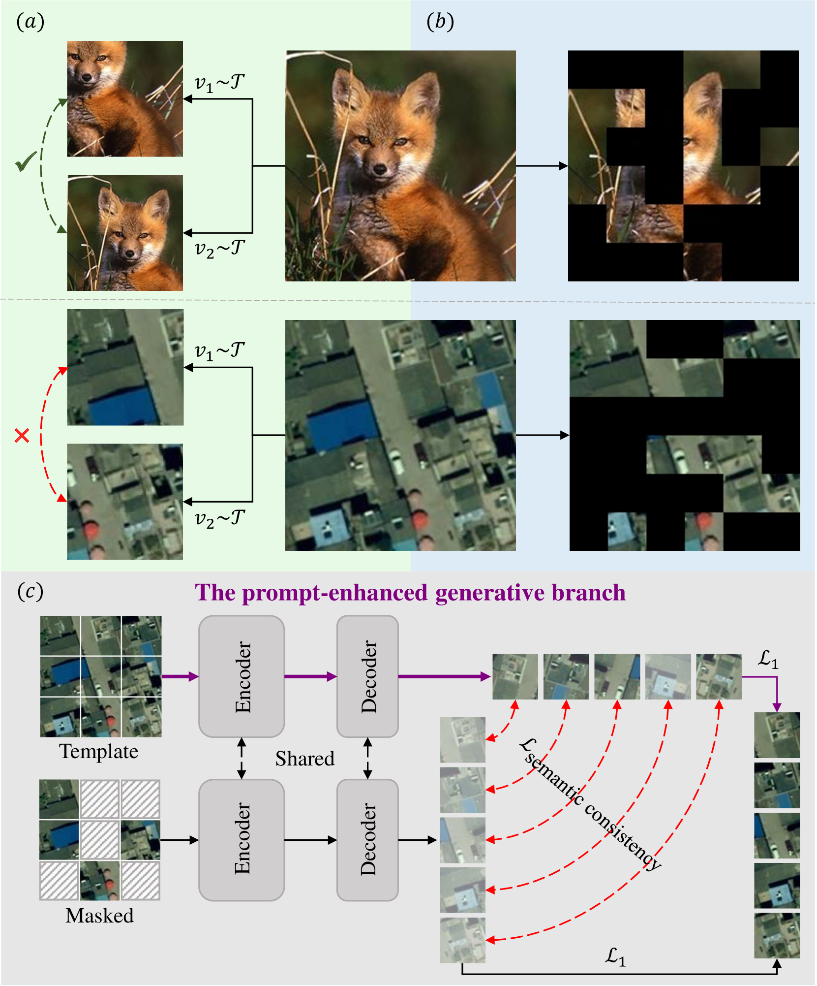
Masked Image Modeling (MIM) has emerged as a pivotal approach for developing foundational visual models in the field of remote sensing (RS). However, current RS datasets are limited in volume and diversity, which significantly constrains the capacity of MIM methods to learn generalizable representations. In this study, we introduce textbf{RS-4M}, a large-scale dataset designed to enable highly efficient MIM training on RS images. RS-4M comprises 4 million optical images encompassing abundant and fine-grained RS visual tasks, including object-level detection and pixel-level segmentation. Compared to natural images, RS images often contain massive redundant background pixels, which limits the training efficiency of the conventional MIM models. To address this, we propose an efficient MIM method, termed textbf{SelectiveMAE}, which dynamically encodes and reconstructs a subset of patch tokens selected based on their semantic richness. SelectiveMAE roots in a progressive semantic token selection module, which evolves from reconstructing semantically analogical tokens to encoding complementary semantic dependencies. This approach transforms conventional MIM training into a progressive feature learning process, enabling SelectiveMAE to efficiently learn robust representations of RS images. Extensive experiments show that SelectiveMAE significantly boosts training efficiency by 2.2-2.7 times and enhances the classification, detection, and segmentation performance of the baseline MIM model.The dataset, source code, and trained models will be released.
Create account to get full access
This summary was produced with help from an AI and may contain inaccuracies - check out the links to read the original source documents!
Related Papers
🖼️
Exploring Masked Autoencoders for Sensor-Agnostic Image Retrieval in Remote Sensing
Jakob Hackstein, Gencer Sumbul, Kai Norman Clasen, Begum Demir
0
0
Self-supervised learning through masked autoencoders (MAEs) has recently attracted great attention for remote sensing (RS) image representation learning, and thus embodies a significant potential for content-based image retrieval (CBIR) from ever-growing RS image archives. However, the existing studies on MAEs in RS assume that the considered RS images are acquired by a single image sensor, and thus are only suitable for uni-modal CBIR problems. The effectiveness of MAEs for cross-sensor CBIR, which aims to search semantically similar images across different image modalities, has not been explored yet. In this paper, we take the first step to explore the effectiveness of MAEs for sensor-agnostic CBIR in RS. To this end, we present a systematic overview on the possible adaptations of the vanilla MAE to exploit masked image modeling on multi-sensor RS image archives (denoted as cross-sensor masked autoencoders [CSMAEs]). Based on different adjustments applied to the vanilla MAE, we introduce different CSMAE models. We also provide an extensive experimental analysis of these CSMAE models. We finally derive a guideline to exploit masked image modeling for uni-modal and cross-modal CBIR problems in RS. The code of this work is publicly available at https://github.com/jakhac/CSMAE.
4/12/2024

A$^{2}$-MAE: A spatial-temporal-spectral unified remote sensing pre-training method based on anchor-aware masked autoencoder
Lixian Zhang, Yi Zhao, Runmin Dong, Jinxiao Zhang, Shuai Yuan, Shilei Cao, Mengxuan Chen, Juepeng Zheng, Weijia Li, Wei Liu, Wayne Zhang, Litong Feng, Haohuan Fu
0
0
Vast amounts of remote sensing (RS) data provide Earth observations across multiple dimensions, encompassing critical spatial, temporal, and spectral information which is essential for addressing global-scale challenges such as land use monitoring, disaster prevention, and environmental change mitigation. Despite various pre-training methods tailored to the characteristics of RS data, a key limitation persists: the inability to effectively integrate spatial, temporal, and spectral information within a single unified model. To unlock the potential of RS data, we construct a Spatial-Temporal-Spectral Structured Dataset (STSSD) characterized by the incorporation of multiple RS sources, diverse coverage, unified locations within image sets, and heterogeneity within images. Building upon this structured dataset, we propose an Anchor-Aware Masked AutoEncoder method (A$^{2}$-MAE), leveraging intrinsic complementary information from the different kinds of images and geo-information to reconstruct the masked patches during the pre-training phase. A$^{2}$-MAE integrates an anchor-aware masking strategy and a geographic encoding module to comprehensively exploit the properties of RS images. Specifically, the proposed anchor-aware masking strategy dynamically adapts the masking process based on the meta-information of a pre-selected anchor image, thereby facilitating the training on images captured by diverse types of RS sources within one model. Furthermore, we propose a geographic encoding method to leverage accurate spatial patterns, enhancing the model generalization capabilities for downstream applications that are generally location-related. Extensive experiments demonstrate our method achieves comprehensive improvements across various downstream tasks compared with existing RS pre-training methods, including image classification, semantic segmentation, and change detection tasks.
6/18/2024
CtxMIM: Context-Enhanced Masked Image Modeling for Remote Sensing Image Understanding
Mingming Zhang, Qingjie Liu, Yunhong Wang
0
0
Learning representations through self-supervision on unlabeled data has proven highly effective for understanding diverse images. However, remote sensing images often have complex and densely populated scenes with multiple land objects and no clear foreground objects. This intrinsic property generates high object density, resulting in false positive pairs or missing contextual information in self-supervised learning. To address these problems, we propose a context-enhanced masked image modeling method (CtxMIM), a simple yet efficient MIM-based self-supervised learning for remote sensing image understanding. CtxMIM formulates original image patches as a reconstructive template and employs a Siamese framework to operate on two sets of image patches. A context-enhanced generative branch is introduced to provide contextual information through context consistency constraints in the reconstruction. With the simple and elegant design, CtxMIM encourages the pre-training model to learn object-level or pixel-level features on a large-scale dataset without specific temporal or geographical constraints. Finally, extensive experiments show that features learned by CtxMIM outperform fully supervised and state-of-the-art self-supervised learning methods on various downstream tasks, including land cover classification, semantic segmentation, object detection, and instance segmentation. These results demonstrate that CtxMIM learns impressive remote sensing representations with high generalization and transferability. Code and data will be made public available.
5/24/2024

Towards a multimodal framework for remote sensing image change retrieval and captioning
Roger Ferrod, Luigi Di Caro, Dino Ienco
0
0
Recently, there has been increasing interest in multimodal applications that integrate text with other modalities, such as images, audio and video, to facilitate natural language interactions with multimodal AI systems. While applications involving standard modalities have been extensively explored, there is still a lack of investigation into specific data modalities such as remote sensing (RS) data. Despite the numerous potential applications of RS data, including environmental protection, disaster monitoring and land planning, available solutions are predominantly focused on specific tasks like classification, captioning and retrieval. These solutions often overlook the unique characteristics of RS data, such as its capability to systematically provide information on the same geographical areas over time. This ability enables continuous monitoring of changes in the underlying landscape. To address this gap, we propose a novel foundation model for bi-temporal RS image pairs, in the context of change detection analysis, leveraging Contrastive Learning and the LEVIR-CC dataset for both captioning and text-image retrieval. By jointly training a contrastive encoder and captioning decoder, our model add text-image retrieval capabilities, in the context of bi-temporal change detection, while maintaining captioning performances that are comparable to the state of the art. We release the source code and pretrained weights at: https://github.com/rogerferrod/RSICRC.
6/21/2024