SEN12-WATER: A New Dataset for Hydrological Applications and its Benchmarking

0
🤔
Sign in to get full access
Overview
- This paper presents a new deep learning approach called Quanv4EO for Earth observation tasks
- The key innovation is the use of "quanvolutional" neural networks, which combine quantum computing and convolutional neural networks
- The authors demonstrate the effectiveness of Quanv4EO on several Earth observation benchmarks, showing improved performance over traditional CNN models
Plain English Explanation
The paper introduces a new deep learning technique called Quanv4EO for working with Earth observation data. Traditional convolutional neural networks (CNNs) are commonly used for these types of tasks, but the authors have developed a new approach that combines CNNs with principles from quantum computing.
The key idea is to use "quanvolutional" layers, which apply quantum-inspired operations to extract features from the input data. This allows the model to capture more complex patterns and relationships compared to standard CNNs. The authors show that Quanv4EO outperforms traditional CNN models on several benchmark datasets for Earth observation tasks like flood mapping.
Overall, this research demonstrates how principles from quantum computing can be leveraged to improve the performance of deep learning models for important real-world applications in the field of Earth observation.
Technical Explanation
The core innovation of the Quanv4EO approach is the use of "quanvolutional" layers, which combine quantum computing concepts with the structure of traditional convolutional neural networks. Specifically, the quanvolutional layers apply quantum-inspired unitary transformations to the input feature maps, allowing the model to capture more complex and nonlinear relationships in the data.
The authors design a deep neural network architecture that alternates between quanvolutional and pooling layers, followed by fully connected layers for the final prediction. They evaluate Quanv4EO on several benchmark datasets for Earth observation tasks, including flood mapping, water body segmentation, and land cover classification. The results show that Quanv4EO consistently outperforms traditional CNN baselines, demonstrating the advantages of the quantum-inspired approach.
Critical Analysis
The paper provides a thorough evaluation of the Quanv4EO approach on multiple benchmark datasets, which lends credibility to the claimed performance improvements. However, the authors do not delve deeply into the specific mechanisms by which the quanvolutional layers enhance the model's representational capacity. More analysis and visualization of the learned features could help elucidate the advantages of the quantum-inspired approach.
Additionally, the authors acknowledge that Quanv4EO requires more computational resources compared to standard CNNs, which could limit its practical deployment in certain real-world scenarios. Further research is needed to explore ways of improving the efficiency of the quantum-inspired components without sacrificing performance.
Conclusion
This paper presents a novel deep learning approach called Quanv4EO that leverages principles from quantum computing to enhance the performance of Earth observation tasks. The key innovation is the use of quanvolutional layers, which allow the model to capture more complex patterns in the data compared to traditional convolutional neural networks.
The experimental results demonstrate the effectiveness of Quanv4EO across several benchmark datasets, highlighting its potential to advance the state-of-the-art in important applications like flood mapping and water body segmentation. While the increased computational requirements are a limitation, this research shows how quantum-inspired techniques can be a valuable tool for improving the capabilities of deep learning models in the domain of Earth observation.
This summary was produced with help from an AI and may contain inaccuracies - check out the links to read the original source documents!
Related Papers
🤔
0
SEN12-WATER: A New Dataset for Hydrological Applications and its Benchmarking
Luigi Russo, Francesco Mauro, Alessandro Sebastianelli, Paolo Gamba, Silvia Liberata Ullo
Climate change and increasing droughts pose significant challenges to water resource management around the world. These problems lead to severe water shortages that threaten ecosystems, agriculture, and human communities. To advance the fight against these challenges, we present a new dataset, SEN12-WATER, along with a benchmark using a novel end-to-end Deep Learning (DL) framework for proactive drought-related analysis. The dataset, identified as a spatiotemporal datacube, integrates SAR polarization, elevation, slope, and multispectral optical bands. Our DL framework enables the analysis and estimation of water losses over time in reservoirs of interest, revealing significant insights into water dynamics for drought analysis by examining temporal changes in physical quantities such as water volume. Our methodology takes advantage of the multitemporal and multimodal characteristics of the proposed dataset, enabling robust generalization and advancing understanding of drought, contributing to climate change resilience and sustainable water resource management. The proposed framework involves, among the several components, speckle noise removal from SAR data, a water body segmentation through a U-Net architecture, the time series analysis, and the predictive capability of a Time-Distributed-Convolutional Neural Network (TD-CNN). Results are validated through ground truth data acquired on-ground via dedicated sensors and (tailored) metrics, such as Precision, Recall, Intersection over Union, Mean Squared Error, Structural Similarity Index Measure and Peak Signal-to-Noise Ratio.
Read more9/26/2024

0
UrbanSARFloods: Sentinel-1 SLC-Based Benchmark Dataset for Urban and Open-Area Flood Mapping
Jie Zhao, Zhitong Xiong, Xiao Xiang Zhu
Due to its cloud-penetrating capability and independence from solar illumination, satellite Synthetic Aperture Radar (SAR) is the preferred data source for large-scale flood mapping, providing global coverage and including various land cover classes. However, most studies on large-scale SAR-derived flood mapping using deep learning algorithms have primarily focused on flooded open areas, utilizing available open-access datasets (e.g., Sen1Floods11) and with limited attention to urban floods. To address this gap, we introduce textbf{UrbanSARFloods}, a floodwater dataset featuring pre-processed Sentinel-1 intensity data and interferometric coherence imagery acquired before and during flood events. It contains 8,879 $512times 512$ chips covering 807,500 $km^2$ across 20 land cover classes and 5 continents, spanning 18 flood events. We used UrbanSARFloods to benchmark existing state-of-the-art convolutional neural networks (CNNs) for segmenting open and urban flood areas. Our findings indicate that prevalent approaches, including the Weighted Cross-Entropy (WCE) loss and the application of transfer learning with pretrained models, fall short in overcoming the obstacles posed by imbalanced data and the constraints of a small training dataset. Urban flood detection remains challenging. Future research should explore strategies for addressing imbalanced data challenges and investigate transfer learning's potential for SAR-based large-scale flood mapping. Besides, expanding this dataset to include additional flood events holds promise for enhancing its utility and contributing to advancements in flood mapping techniques.
Read more6/7/2024
0
A Dataset for Research on Water Sustainability
Pranjol Sen Gupta, Md Rajib Hossen, Pengfei Li, Shaolei Ren, Mohammad A. Islam
Freshwater scarcity is a global problem that requires collective efforts across all industry sectors. Nevertheless, a lack of access to operational water footprint data bars many applications from exploring optimization opportunities hidden within the temporal and spatial variations. To break this barrier into research in water sustainability, we build a dataset for operation direct water usage in the cooling systems and indirect water embedded in electricity generation. Our dataset consists of the hourly water efficiency of major U.S. cities and states from 2019 to 2023. We also offer cooling system models that capture the impact of weather on water efficiency. We present a preliminary analysis of our dataset and discuss three potential applications that can benefit from it. Our dataset is publicly available at Open Science Framework (OSF)
Read more5/30/2024
0
Time Distributed Deep Learning models for Purely Exogenous Forecasting. Application to Water Table Depth Prediction using Weather Image Time Series
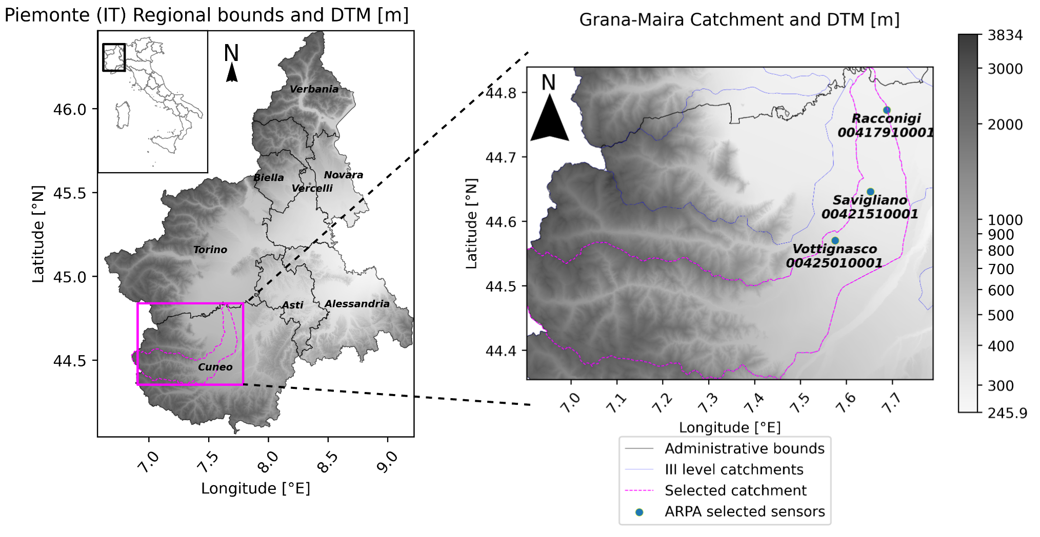
Matteo Salis, Abdourrahmane M. Atto, Stefano Ferraris, Rosa Meo
Groundwater resources are one of the most relevant elements in the water cycle, therefore developing models to accurately predict them is a pivotal task in the sustainable resources management framework. Deep Learning (DL) models have been revealed very effective in hydrology, especially by feeding spatially distributed data (e.g. raster data). In many regions, hydrological measurements are difficult to obtain regularly or periodically in time, and in some cases, last available data are not up to date. Reversely, weather data, which significantly impacts water resources, are usually more available and with higher quality. More specifically, we have proposed two different DL models to predict the water table depth in the Grana-Maira catchment (Piemonte, IT) using only exogenous weather image time series. To deal with the image time series, both models are made of a first Time Distributed Convolutional Neural Network (TDC) which encodes the image available at each time step into a vectorial representation. The first model, TDC-LSTM uses then a Sequential Module based on an LSTM layer to learn temporal relations and output the predictions. The second model, TDC-UnPWaveNet uses instead a new version of the WaveNet architecture, adapted here to output a sequence shorter and completely shifted in the future with respect to the input one. To this aim, and to deal with the different sequence lengths in the UnPWaveNet, we have designed a new Channel Distributed layer, that acts like a Time Distributed one but on the channel dimension, i.e. applying the same set of operations to each channel of the input. TDC-LSTM and TDC-UnPWaveNet have shown both remarkable results. However, the two models have focused on different learnable information: TDC-LSTM has focused more on lowering the bias, while the TDC-UnPWaveNet has focused more on the temporal dynamics maximising correlation and KGE.
Read more9/23/2024