UrbanSARFloods: Sentinel-1 SLC-Based Benchmark Dataset for Urban and Open-Area Flood Mapping

0

Sign in to get full access
Overview
• This paper introduces a new dataset called "UrbanSARFloods" that provides Sentinel-1 single-look complex (SLC) data for urban and open-area flood mapping.
• The dataset includes Sentinel-1 SLC data for multiple flood events in diverse geographical locations, along with detailed ground truth annotations.
• The authors aim to enable research on flood mapping in complex urban environments using high-resolution synthetic aperture radar (SAR) data.
Plain English Explanation
The researchers have created a new dataset called "UrbanSARFloods" that contains satellite radar data from the Sentinel-1 satellite. This data was collected during several flood events in different parts of the world, and the researchers have also provided detailed information about what was actually flooded on the ground.
The goal of this dataset is to help other researchers who are working on developing computer vision and machine learning models to detect and map floods, especially in urban areas. Urban environments can be challenging for flood mapping because there are many buildings, roads, and other man-made structures that can make it harder to see the flooded areas in the satellite data. By providing this high-quality dataset, the researchers hope to advance the state-of-the-art in using satellite radar data for urban flood mapping.
Technical Explanation
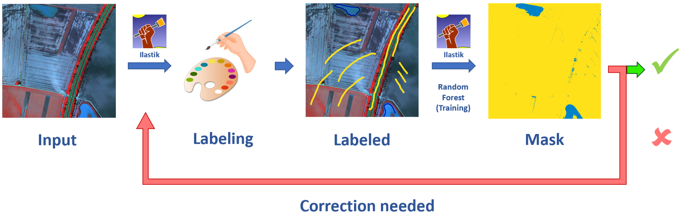
The "UrbanSARFloods" dataset contains Sentinel-1 single-look complex (SLC) data for multiple flood events in diverse geographical locations, including urban and open areas. SLC data provides the full phase and amplitude information from the satellite radar, which is important for advanced processing techniques.
The dataset includes annotations that detail the ground truth flood extents, which were manually created by expert interpreters. This allows for rigorous evaluation of flood mapping algorithms, especially in complex urban environments where automatic flood detection can be challenging.
The authors suggest that this dataset can enable research on topics such as link to FAD-SAR: Novel Fishing Activity Detection System, link to EVANet: Elevation-Guided Flood Extent Mapping from Satellite Imagery, and link to Flood Data Analysis for SpaceNet 8 using Apache Spark. The availability of high-quality, annotated SAR data for urban floods can help advance the state-of-the-art in this important field.
Critical Analysis
The authors acknowledge several limitations of the UrbanSARFloods dataset, such as the relatively small number of flood events and the lack of temporal information (e.g., flood duration). They also note that the ground truth annotations, while detailed, may still contain some inaccuracies.
Additionally, the dataset is focused on Sentinel-1 data, which may limit its applicability to other SAR sensors. Further research could explore the use of data from multiple SAR platforms to create more comprehensive flood mapping capabilities.
Overall, the UrbanSARFloods dataset represents a valuable contribution to the field of flood mapping, particularly in urban areas. However, as with any research, there is always room for improvement and additional work to address the remaining challenges in this important domain.
Conclusion
The UrbanSARFloods dataset provides a new benchmark for evaluating flood mapping algorithms in complex urban environments using high-resolution Sentinel-1 SAR data. By making this dataset publicly available, the authors hope to enable and accelerate research on topics such as link to Open Source Tool for Mapping War Destruction at Scale and link to Improving Interpretability of Deep Active Learning for Flood Inundation Mapping. The availability of this comprehensive, annotated dataset can lead to significant advancements in the field of satellite-based flood mapping, with important implications for disaster response and urban planning.
This summary was produced with help from an AI and may contain inaccuracies - check out the links to read the original source documents!
Related Papers
0
UrbanSARFloods: Sentinel-1 SLC-Based Benchmark Dataset for Urban and Open-Area Flood Mapping
Jie Zhao, Zhitong Xiong, Xiao Xiang Zhu
Due to its cloud-penetrating capability and independence from solar illumination, satellite Synthetic Aperture Radar (SAR) is the preferred data source for large-scale flood mapping, providing global coverage and including various land cover classes. However, most studies on large-scale SAR-derived flood mapping using deep learning algorithms have primarily focused on flooded open areas, utilizing available open-access datasets (e.g., Sen1Floods11) and with limited attention to urban floods. To address this gap, we introduce textbf{UrbanSARFloods}, a floodwater dataset featuring pre-processed Sentinel-1 intensity data and interferometric coherence imagery acquired before and during flood events. It contains 8,879 $512times 512$ chips covering 807,500 $km^2$ across 20 land cover classes and 5 continents, spanning 18 flood events. We used UrbanSARFloods to benchmark existing state-of-the-art convolutional neural networks (CNNs) for segmenting open and urban flood areas. Our findings indicate that prevalent approaches, including the Weighted Cross-Entropy (WCE) loss and the application of transfer learning with pretrained models, fall short in overcoming the obstacles posed by imbalanced data and the constraints of a small training dataset. Urban flood detection remains challenging. Future research should explore strategies for addressing imbalanced data challenges and investigate transfer learning's potential for SAR-based large-scale flood mapping. Besides, expanding this dataset to include additional flood events holds promise for enhancing its utility and contributing to advancements in flood mapping techniques.
Read more6/7/2024
🤯
0
Kuro Siwo: 33 billion $m^2$ under the water. A global multi-temporal satellite dataset for rapid flood mapping
Nikolaos Ioannis Bountos, Maria Sdraka, Angelos Zavras, Ilektra Karasante, Andreas Karavias, Themistocles Herekakis, Angeliki Thanasou, Dimitrios Michail, Ioannis Papoutsis
Global floods, exacerbated by climate change, pose severe threats to human life, infrastructure, and the environment. Recent catastrophic events in Pakistan and New Zealand underscore the urgent need for precise flood mapping to guide restoration efforts, understand vulnerabilities, and prepare for future occurrences. While Synthetic Aperture Radar (SAR) remote sensing offers day-and-night, all-weather imaging capabilities, its application in deep learning for flood segmentation is limited by the lack of large annotated datasets. To address this, we introduce Kuro Siwo, a manually annotated multi-temporal dataset, spanning 43 flood events globally. Our dataset maps more than 338 billion $m^2$ of land, with 33 billion designated as either flooded areas or permanent water bodies. Kuro Siwo includes a highly processed product optimized for flood mapping based on SAR Ground Range Detected, and a primal SAR Single Look Complex product with minimal preprocessing, designed to promote research on the exploitation of both the phase and amplitude information and to offer maximum flexibility for downstream task preprocessing. To leverage advances in large scale self-supervised pretraining methods for remote sensing data, we augment Kuro Siwo with a large unlabeled set of SAR samples. Finally, we provide an extensive benchmark, namely BlackBench, offering strong baselines for a diverse set of flood events from Europe, America, Africa, Asia and Australia.
Read more6/11/2024
0
BlessemFlood21: Advancing Flood Analysis with a High-Resolution Georeferenced Dataset for Humanitarian Aid Support
Vladyslav Polushko, Alexander Jenal, Jens Bongartz, Immanuel Weber, Damjan Hatic, Ronald Rosch, Thomas Marz, Markus Rauhut, Andreas Weinmann
Floods are an increasingly common global threat, causing emergencies and severe damage to infrastructure. During crises, organisations such as the World Food Programme use remotely sensed imagery, typically obtained through drones, for rapid situational analysis to plan life-saving actions. Computer Vision tools are needed to support task force experts on-site in the evaluation of the imagery to improve their efficiency and to allocate resources strategically. We introduce the BlessemFlood21 dataset to stimulate research on efficient flood detection tools. The imagery was acquired during the 2021 Erftstadt-Blessem flooding event and consists of high-resolution and georeferenced RGB-NIR images. In the resulting RGB dataset, the images are supplemented with detailed water masks, obtained via a semi-supervised human-in-the-loop technique, where in particular the NIR information is leveraged to classify pixels as either water or non-water. We evaluate our dataset by training and testing established Deep Learning models for semantic segmentation. With BlessemFlood21 we provide labeled high-resolution RGB data and a baseline for further development of algorithmic solutions tailored to flood detection in RGB imagery.
Read more7/9/2024

0
WV-Net: A foundation model for SAR WV-mode satellite imagery trained using contrastive self-supervised learning on 10 million images
Yannik Glaser, Justin E. Stopa, Linnea M. Wolniewicz, Ralph Foster, Doug Vandemark, Alexis Mouche, Bertrand Chapron, Peter Sadowski
The European Space Agency's Copernicus Sentinel-1 (S-1) mission is a constellation of C-band synthetic aperture radar (SAR) satellites that provide unprecedented monitoring of the world's oceans. S-1's wave mode (WV) captures 20x20 km image patches at 5 m pixel resolution and is unaffected by cloud cover or time-of-day. The mission's open data policy has made SAR data easily accessible for a range of applications, but the need for manual image annotations is a bottleneck that hinders the use of machine learning methods. This study uses nearly 10 million WV-mode images and contrastive self-supervised learning to train a semantic embedding model called WV-Net. In multiple downstream tasks, WV-Net outperforms a comparable model that was pre-trained on natural images (ImageNet) with supervised learning. Experiments show improvements for estimating wave height (0.50 vs 0.60 RMSE using linear probing), estimating near-surface air temperature (0.90 vs 0.97 RMSE), and performing multilabel-classification of geophysical and atmospheric phenomena (0.96 vs 0.95 micro-averaged AUROC). WV-Net embeddings are also superior in an unsupervised image-retrieval task and scale better in data-sparse settings. Together, these results demonstrate that WV-Net embeddings can support geophysical research by providing a convenient foundation model for a variety of data analysis and exploration tasks.
Read more6/28/2024