Super-Resolution works for coastal simulations

0
Sign in to get full access
Overview
- Coastal simulations are important for understanding and predicting environmental phenomena like floods, erosion, and sea level rise
- Traditional simulation methods can be computationally expensive and produce low-resolution results
- This paper explores using deep neural networks for super-resolution, which can enhance the resolution of coastal simulations
Plain English Explanation
Coastal regions are important to study because they are vulnerable to environmental changes like flooding, erosion, and rising sea levels. To understand and predict these phenomena, scientists use computer simulations of coastal environments. However, these simulations can be very complex and time-consuming to run, often producing results at a low resolution that don't capture all the important details.
The researchers in this paper investigated using a technique called super-resolution to enhance the resolution of coastal simulations. Super-resolution is a machine learning method that can take a low-quality image or simulation and intelligently "fill in the gaps" to produce a higher-quality version.
The key idea is to train a deep neural network on examples of low-res and high-res coastal simulations. Once trained, the network can then be applied to new low-res simulations to automatically generate higher-resolution outputs. This could allow for faster, more detailed coastal modeling without the usual computational expense.
Technical Explanation
The paper Super-Resolution works for coastal simulations investigates using deep learning-based super-resolution techniques to enhance the resolution of coastal simulations.
Specifically, the researchers use a discontinuous Galerkin (DG) method to solve the shallow water equations, which model coastal hydrodynamics. They then train a deep neural network to map low-resolution DG simulations to their corresponding high-resolution counterparts.
The network architecture consists of multiple convolutional and transposed convolutional layers to progressively upscale the spatial resolution. The model is trained on pairs of low and high-res DG simulations to learn the mapping function.
Experiments show that this super-resolution approach can significantly improve the resolution of coastal simulations at a fraction of the computational cost of running the full high-resolution model. The enhanced simulations are able to better capture important coastal features like wave patterns and shoreline dynamics.
Critical Analysis
The paper provides a promising proof-of-concept for using deep learning super-resolution to improve the efficiency and fidelity of coastal simulations. However, the authors note that the technique may be limited to smooth, well-behaved coastal environments. More complex scenarios with rapid changes or discontinuities may be difficult to super-resolve accurately.
Additionally, the paper only evaluates the method on 2D simulations. Extending this approach to fully 3D coastal models could present additional challenges. The authors suggest further research is needed to understand the applicability and limitations of this technique across a wider range of coastal environments and simulation modalities.
Ultimately, while this super-resolution approach seems effective for the specific test cases presented, more work is needed to determine its general robustness and suitability for real-world coastal modeling and prediction tasks.
Conclusion
This paper demonstrates that deep learning-based super-resolution can be a powerful tool for enhancing the resolution and fidelity of coastal simulations. By training neural networks to intelligently "fill in the gaps" in low-res coastal models, the technique can produce high-quality results at a fraction of the computational cost of running full high-resolution simulations.
If the method can be further developed and generalized, it could lead to significant advancements in coastal modeling and prediction capabilities. This could have important implications for understanding and mitigating the impacts of coastal environmental changes, from flooding and erosion to sea level rise. Overall, the findings represent an exciting step forward in the application of machine learning to scientific computing and simulation.
This summary was produced with help from an AI and may contain inaccuracies - check out the links to read the original source documents!
Related Papers
0
Super-Resolution works for coastal simulations
Zhi-Song Liu, Markus Buttner, Vadym Aizinger, Andreas Rupp
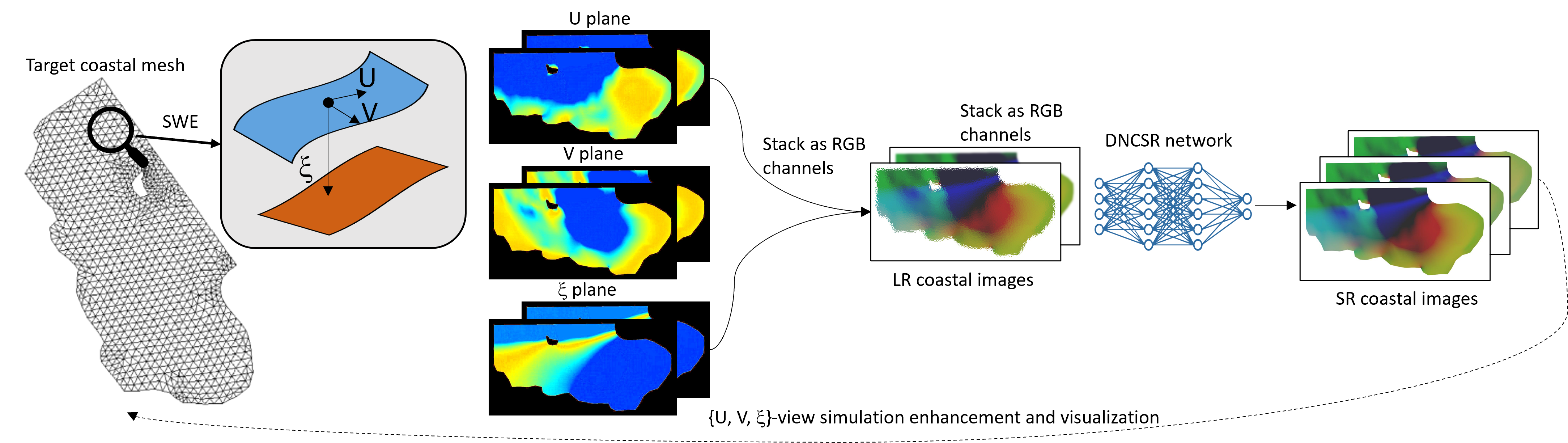
Learning fine-scale details of a coastal ocean simulation from a coarse representation is a challenging task. For real-world applications, high-resolution simulations are necessary to advance understanding of many coastal processes, specifically, to predict flooding resulting from tsunamis and storm surges. We propose a Deep Network for Coastal Super-Resolution (DNCSR) for spatiotemporal enhancement to efficiently learn the high-resolution numerical solution. Given images of coastal simulations produced on low-resolution computational meshes using low polynomial order discontinuous Galerkin discretizations and a coarse temporal resolution, the proposed DNCSR learns to produce high-resolution free surface elevation and velocity visualizations in both time and space. To efficiently model the dynamic changes over time and space, we propose grid-aware spatiotemporal attention to project the temporal features to the spatial domain for non-local feature matching. The coordinate information is also utilized via positional encoding. For the final reconstruction, we use the spatiotemporal bilinear operation to interpolate the missing frames and then expand the feature maps to the frequency domain for residual mapping. Besides data-driven losses, the proposed physics-informed loss guarantees gradient consistency and momentum changes. Their combination contributes to the overall 24% improvements in RMSE. To train the proposed model, we propose a large-scale coastal simulation dataset and use it for model optimization and evaluation. Our method shows superior super-resolution quality and fast computation compared to the state-of-the-art methods.
Read more8/30/2024
🤿
0
Dynamic Deep Learning Based Super-Resolution For The Shallow Water Equations
Maximilian Witte, Fabricio Rodrigues Lapolli, Philip Freese, Sebastian Gotschel, Daniel Ruprecht, Peter Korn, Christopher Kadow
Using the nonlinear shallow water equations as benchmark, we demonstrate that a simulation with the ICON-O ocean model with a 20km resolution that is frequently corrected by a U-net-type neural network can achieve discretization errors of a simulation with 10km resolution. The network, originally developed for image-based super-resolution in post-processing, is trained to compute the difference between solutions on both meshes and is used to correct the coarse mesh every 12h. Our setup is the Galewsky test case, modeling transition of a barotropic instability into turbulent flow. We show that the ML-corrected coarse resolution run correctly maintains a balance flow and captures the transition to turbulence in line with the higher resolution simulation. After 8 day of simulation, the $L_2$-error of the corrected run is similar to a simulation run on the finer mesh. While mass is conserved in the corrected runs, we observe some spurious generation of kinetic energy.
Read more4/10/2024
👁️
0
An Operator Learning Framework for Spatiotemporal Super-resolution of Scientific Simulations
Valentin Duruisseaux, Amit Chakraborty
In numerous contexts, high-resolution solutions to partial differential equations are required to capture faithfully essential dynamics which occur at small spatiotemporal scales, but these solutions can be very difficult and slow to obtain using traditional methods due to limited computational resources. A recent direction to circumvent these computational limitations is to use machine learning techniques for super-resolution, to reconstruct high-resolution numerical solutions from low-resolution simulations which can be obtained more efficiently. The proposed approach, the Super Resolution Operator Network (SROpNet), frames super-resolution as an operator learning problem and draws inspiration from existing architectures to learn continuous representations of solutions to parametric differential equations from low-resolution approximations, which can then be evaluated at any desired location. In addition, no restrictions are imposed on the locations of (the fixed number of) spatiotemporal sensors at which the low-resolution approximations are provided, thereby enabling the consideration of a broader spectrum of problems arising in practice, for which many existing super-resolution approaches are not well-suited.
Read more4/9/2024
🌿
0
Cross-sensor super-resolution of irregularly sampled Sentinel-2 time series
Aimi Okabayashi (IRISA, OBELIX), Nicolas Audebert (CEDRIC - VERTIGO, CNAM, LaSTIG, IGN), Simon Donike (IPL), Charlotte Pelletier (OBELIX, IRISA)
Satellite imaging generally presents a trade-off between the frequency of acquisitions and the spatial resolution of the images. Super-resolution is often advanced as a way to get the best of both worlds. In this work, we investigate multi-image super-resolution of satellite image time series, i.e. how multiple images of the same area acquired at different dates can help reconstruct a higher resolution observation. In particular, we extend state-of-the-art deep single and multi-image super-resolution algorithms, such as SRDiff and HighRes-net, to deal with irregularly sampled Sentinel-2 time series. We introduce BreizhSR, a new dataset for 4x super-resolution of Sentinel-2 time series using very high-resolution SPOT-6 imagery of Brittany, a French region. We show that using multiple images significantly improves super-resolution performance, and that a well-designed temporal positional encoding allows us to perform super-resolution for different times of the series. In addition, we observe a trade-off between spectral fidelity and perceptual quality of the reconstructed HR images, questioning future directions for super-resolution of Earth Observation data.
Read more4/26/2024