SynRS3D: A Synthetic Dataset for Global 3D Semantic Understanding from Monocular Remote Sensing Imagery
2406.18151
0
0

Abstract
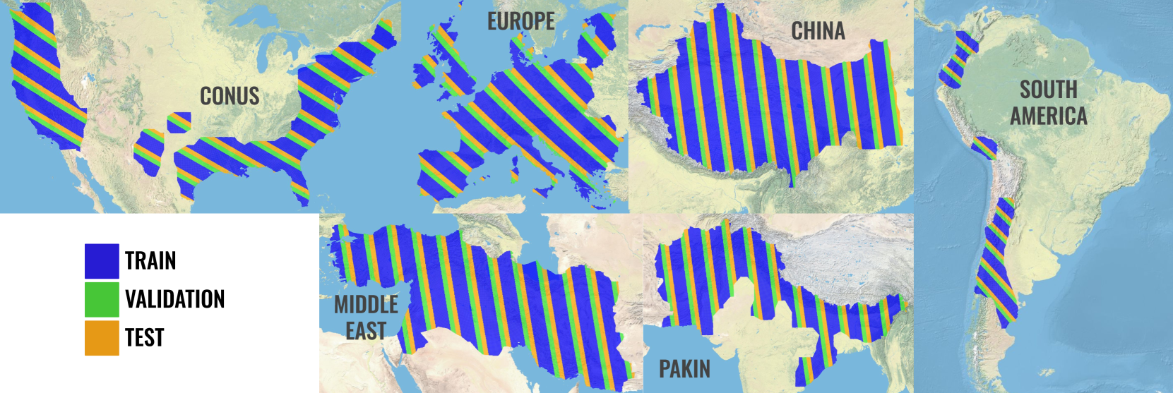
Global semantic 3D understanding from single-view high-resolution remote sensing (RS) imagery is crucial for Earth Observation (EO). However, this task faces significant challenges due to the high costs of annotations and data collection, as well as geographically restricted data availability. To address these challenges, synthetic data offer a promising solution by being easily accessible and thus enabling the provision of large and diverse datasets. We develop a specialized synthetic data generation pipeline for EO and introduce SynRS3D, the largest synthetic RS 3D dataset. SynRS3D comprises 69,667 high-resolution optical images that cover six different city styles worldwide and feature eight land cover types, precise height information, and building change masks. To further enhance its utility, we develop a novel multi-task unsupervised domain adaptation (UDA) method, RS3DAda, coupled with our synthetic dataset, which facilitates the RS-specific transition from synthetic to real scenarios for land cover mapping and height estimation tasks, ultimately enabling global monocular 3D semantic understanding based on synthetic data. Extensive experiments on various real-world datasets demonstrate the adaptability and effectiveness of our synthetic dataset and proposed RS3DAda method. SynRS3D and related codes will be available.
Create account to get full access
Overview
- This paper introduces a new synthetic dataset called SynRS3D for global 3D semantic understanding from monocular remote sensing imagery.
- The dataset aims to bridge the gap between synthetic and real-world data for 3D scene understanding tasks using satellite and aerial imagery.
- The authors propose novel techniques to generate high-quality synthetic data with realistic appearance and accurate 3D annotations.
Plain English Explanation
The paper presents a new synthetic dataset called SynRS3D that can be used to train machine learning models for understanding 3D scenes from single satellite or aerial images. Current methods for 3D scene understanding often struggle with the limited availability of real-world annotated data, especially for global-scale scenes.
To address this, the researchers created SynRS3D, a large-scale synthetic dataset that mimics the visual characteristics and 3D structure of real-world remote sensing imagery. By using advanced rendering techniques, the authors were able to generate highly realistic-looking scenes with accurate 3D annotations that can be used to train machine learning models. This helps bridge the gap between synthetic and real-world data, making it easier to develop robust 3D understanding algorithms that can be applied to actual satellite and aerial imagery.
Technical Explanation
The authors introduce a new synthetic dataset called SynRS3D that aims to advance the state-of-the-art in 3D semantic understanding from monocular remote sensing imagery. The dataset is designed to mimic the visual characteristics and 3D structure of real-world satellite and aerial imagery at a global scale.
To create the dataset, the researchers developed novel techniques for generating high-quality synthetic scenes with accurate 3D annotations. This includes using advanced rendering pipelines to capture the diverse lighting conditions, material properties, and geometric structures found in real-world remote sensing data. The authors also leveraged procedural modeling techniques to create large-scale virtual environments that encompass a wide range of urban and natural landscapes.
Through extensive experiments, the authors demonstrate that models trained on SynRS3D data can achieve strong performance on 3D understanding tasks when applied to real-world remote sensing imagery. This highlights the dataset's potential to serve as a powerful tool for developing robust algorithms that can scale to global-level 3D scene analysis.
Critical Analysis
The SynRS3D dataset represents a significant step forward in bridging the gap between synthetic and real-world data for 3D semantic understanding from monocular remote sensing imagery. The authors' focus on generating highly realistic scenes with accurate 3D annotations is a key strength, as it allows machine learning models to be trained on data that closely mimics the characteristics of actual satellite and aerial imagery.
However, the paper does not deeply explore the limitations of the synthetic data or potential challenges in transferring models trained on SynRS3D to real-world applications. For example, it is unclear how the dataset handles factors like atmospheric distortions, sensor noise, and geometric distortions that are often present in real-world remote sensing data. Addressing these types of domain gaps could be an important area for future research.
Additionally, while the authors demonstrate the effectiveness of SynRS3D for 3D understanding tasks, the paper does not provide a thorough analysis of the dataset's impact on other relevant applications, such as land-use classification or change detection. Exploring the broader utility of the dataset beyond 3D scene understanding could further showcase its value to the remote sensing community.
Conclusion
The SynRS3D dataset presented in this paper represents a significant contribution to the field of 3D semantic understanding from monocular remote sensing imagery. By leveraging advanced rendering and procedural modeling techniques, the authors have created a large-scale synthetic dataset that closely mimics the visual and 3D characteristics of real-world satellite and aerial imagery.
Experiments show that models trained on SynRS3D data can achieve strong performance when applied to real-world remote sensing data, highlighting the dataset's potential to serve as a powerful tool for developing robust 3D understanding algorithms. While the paper does not fully address the limitations of the synthetic data or its broader applications, the SynRS3D dataset is a valuable resource that can help drive progress in this important area of computer vision and remote sensing research.
This summary was produced with help from an AI and may contain inaccuracies - check out the links to read the original source documents!
Related Papers

Syn-to-Real Unsupervised Domain Adaptation for Indoor 3D Object Detection
Yunsong Wang, Na Zhao, Gim Hee Lee
0
0
The use of synthetic data in indoor 3D object detection offers the potential of greatly reducing the manual labor involved in 3D annotations and training effective zero-shot detectors. However, the complicated domain shifts across syn-to-real indoor datasets remains underexplored. In this paper, we propose a novel Object-wise Hierarchical Domain Alignment (OHDA) framework for syn-to-real unsupervised domain adaptation in indoor 3D object detection. Our approach includes an object-aware augmentation strategy to effectively diversify the source domain data, and we introduce a two-branch adaptation framework consisting of an adversarial training branch and a pseudo labeling branch, in order to simultaneously reach holistic-level and class-level domain alignment. The pseudo labeling is further refined through two proposed schemes specifically designed for indoor UDA. Our adaptation results from synthetic dataset 3D-FRONT to real-world datasets ScanNetV2 and SUN RGB-D demonstrate remarkable mAP25 improvements of 9.7% and 9.1% over Source-Only baselines, respectively, and consistently outperform the methods adapted from 2D and 3D outdoor scenarios. The code will be publicly available upon paper acceptance.
6/18/2024
M3LEO: A Multi-Modal, Multi-Label Earth Observation Dataset Integrating Interferometric SAR and RGB Data
Matthew J Allen, Francisco Dorr, Joseph Alejandro Gallego Mejia, Laura Mart'inez-Ferrer, Anna Jungbluth, Freddie Kalaitzis, Ra'ul Ramos-Poll'an
0
0
Satellite-based remote sensing has revolutionised the way we address global challenges in a rapidly evolving world. Huge quantities of Earth Observation (EO) data are generated by satellite sensors daily, but processing these large datasets for use in ML pipelines is technically and computationally challenging. Specifically, different types of EO data are often hosted on a variety of platforms, with differing availability for Python preprocessing tools. In addition, spatial alignment across data sources and data tiling can present significant technical hurdles for novice users. While some preprocessed EO datasets exist, their content is often limited to optical or near-optical wavelength data, which is ineffective at night or in adverse weather conditions. Synthetic Aperture Radar (SAR), an active sensing technique based on microwave length radiation, offers a viable alternative. However, the application of machine learning to SAR has been limited due to a lack of ML-ready data and pipelines, particularly for the full diversity of SAR data, including polarimetry, coherence and interferometry. We introduce M3LEO, a multi-modal, multi-label EO dataset that includes polarimetric, interferometric, and coherence SAR data derived from Sentinel-1, alongside Sentinel-2 RGB imagery and a suite of labelled tasks for model evaluation. M3LEO spans 17.5TB and contains approximately 10M data chips across six geographic regions. The dataset is complemented by a flexible PyTorch Lightning framework, with configuration management using Hydra. We provide tools to process any dataset available on popular platforms such as Google Earth Engine for integration with our framework. Initial experiments validate the utility of our data and framework, showing that SAR imagery contains information additional to that extractable from RGB data. Data at huggingface.co/M3LEO, and code at github.com/spaceml-org/M3LEO.
6/7/2024
🛠️
Real3D: Scaling Up Large Reconstruction Models with Real-World Images
Hanwen Jiang, Qixing Huang, Georgios Pavlakos
0
0
The default strategy for training single-view Large Reconstruction Models (LRMs) follows the fully supervised route using large-scale datasets of synthetic 3D assets or multi-view captures. Although these resources simplify the training procedure, they are hard to scale up beyond the existing datasets and they are not necessarily representative of the real distribution of object shapes. To address these limitations, in this paper, we introduce Real3D, the first LRM system that can be trained using single-view real-world images. Real3D introduces a novel self-training framework that can benefit from both the existing synthetic data and diverse single-view real images. We propose two unsupervised losses that allow us to supervise LRMs at the pixel- and semantic-level, even for training examples without ground-truth 3D or novel views. To further improve performance and scale up the image data, we develop an automatic data curation approach to collect high-quality examples from in-the-wild images. Our experiments show that Real3D consistently outperforms prior work in four diverse evaluation settings that include real and synthetic data, as well as both in-domain and out-of-domain shapes. Code and model can be found here: https://hwjiang1510.github.io/Real3D/
6/13/2024
🖼️
Semantic Guided Large Scale Factor Remote Sensing Image Super-resolution with Generative Diffusion Prior
Ce Wang, Wanjie Sun
0
0
Remote sensing images captured by different platforms exhibit significant disparities in spatial resolution. Large scale factor super-resolution (SR) algorithms are vital for maximizing the utilization of low-resolution (LR) satellite data captured from orbit. However, existing methods confront challenges in recovering SR images with clear textures and correct ground objects. We introduce a novel framework, the Semantic Guided Diffusion Model (SGDM), designed for large scale factor remote sensing image super-resolution. The framework exploits a pre-trained generative model as a prior to generate perceptually plausible SR images. We further enhance the reconstruction by incorporating vector maps, which carry structural and semantic cues. Moreover, pixel-level inconsistencies in paired remote sensing images, stemming from sensor-specific imaging characteristics, may hinder the convergence of the model and diversity in generated results. To address this problem, we propose to extract the sensor-specific imaging characteristics and model the distribution of them, allowing diverse SR images generation based on imaging characteristics provided by reference images or sampled from the imaging characteristic probability distributions. To validate and evaluate our approach, we create the Cross-Modal Super-Resolution Dataset (CMSRD). Qualitative and quantitative experiments on CMSRD showcase the superiority and broad applicability of our method. Experimental results on downstream vision tasks also demonstrate the utilitarian of the generated SR images. The dataset and code will be publicly available at https://github.com/wwangcece/SGDM
5/14/2024