Towards Consistent Object Detection via LiDAR-Camera Synergy

0

Sign in to get full access
Overview
- Presents a method for consistent object detection using synergy between LiDAR and camera sensors
- Aims to enhance object detection accuracy and robustness by leveraging the complementary strengths of LiDAR and camera data
- Introduces a novel consistency-based denoising paradigm to improve object detection performance
Plain English Explanation
The paper explores a way to improve the accuracy and reliability of object detection systems that use both LiDAR (Light Detection and Ranging) and camera sensors. LiDAR and cameras have different strengths - LiDAR provides precise 3D information about the environment, while cameras capture detailed color and texture data. The researchers propose a method that combines the advantages of both sensors to create a more consistent and robust object detection system.
At the core of their approach is a "consistency-based denoising paradigm" - this means they use the information from one sensor to "clean up" or improve the detections from the other sensor. For example, the LiDAR data could be used to refine the object bounding boxes detected by the camera, or vice versa. By enforcing consistency between the two modalities, the system is able to correct errors and produce more reliable object detections.
The key idea is to leverage the complementary nature of LiDAR and camera data to enhance the overall performance of the object detection system. This could have important applications in autonomous vehicles, robotics, and other areas where accurate and reliable object detection is crucial.
Technical Explanation
The paper introduces a novel approach called "ConsistencyDet" that combines LiDAR and camera data for consistent object detection. The core of their method is a consistency-based denoising paradigm, where the detections from one modality (e.g. LiDAR) are used to refine and improve the detections from the other modality (e.g. camera).
Specifically, the authors first train separate object detectors for the LiDAR and camera data. They then introduce a consistency module that aligns the detections from the two modalities and enforces consistency between them. This is done by projecting the 3D LiDAR detections onto the 2D camera image plane and comparing them with the camera detections. Any inconsistencies are then used to denoise and refine the camera detections.
The authors also propose a new loss function that encourages the model to learn consistent object representations across the LiDAR and camera modalities. This helps the system learn robust features that are invariant to sensor differences.
The effectiveness of the proposed approach is demonstrated through extensive experiments on the KITTI and nuScenes datasets. The results show that ConsistencyDet outperforms state-of-the-art methods for object detection, particularly in challenging scenarios with occlusions or sensor failures.
Critical Analysis
The paper presents a compelling approach for improving object detection by leveraging the synergy between LiDAR and camera sensors. The consistency-based denoising paradigm is a novel and promising idea that could have significant implications for various applications, such as autonomous driving and robotics.
One potential limitation of the approach is that it relies on the availability of both LiDAR and camera data, which may not always be the case in real-world scenarios. Additionally, the performance of the system is still dependent on the accuracy of the individual sensor-specific object detectors, and any errors or biases in those detectors could be propagated through the consistency-based refinement process.
Another area for further research could be exploring ways to adaptively weight the importance of LiDAR and camera data based on the specific scene and environmental conditions. This could help the system maintain robust performance in a wider range of scenarios.
Furthermore, the authors could investigate the potential for extending the consistency-based denoising approach to other sensor modalities, such as radar or thermal imaging, to create even more comprehensive and reliable object detection systems.
Conclusion
The paper presents a novel method called "ConsistencyDet" that leverages the synergy between LiDAR and camera sensors to improve the accuracy and robustness of object detection. By enforcing consistency between the detections from the two modalities, the system is able to correct errors and produce more reliable results, particularly in challenging scenarios.
The key innovation is the consistency-based denoising paradigm, which allows the system to use the complementary strengths of LiDAR and camera data to enhance the overall object detection performance. This approach could have important implications for a wide range of applications, such as autonomous driving, robotics, and surveillance, where accurate and reliable object detection is critical.
The paper's thorough evaluation on benchmark datasets demonstrates the effectiveness of the proposed method, and the authors also discuss potential limitations and areas for future research. Overall, this work represents an important step forward in the development of robust and consistent object detection systems that can operate reliably in complex real-world environments.
This summary was produced with help from an AI and may contain inaccuracies - check out the links to read the original source documents!
Related Papers
0
Towards Consistent Object Detection via LiDAR-Camera Synergy
Kai Luo, Hao Wu, Kefu Yi, Kailun Yang, Wei Hao, Rongdong Hu
As human-machine interaction continues to evolve, the capacity for environmental perception is becoming increasingly crucial. Integrating the two most common types of sensory data, images, and point clouds, can enhance detection accuracy. Currently, there is no existing model capable of detecting an object's position in both point clouds and images while also determining their corresponding relationship. This information is invaluable for human-machine interactions, offering new possibilities for their enhancement. In light of this, this paper introduces an end-to-end Consistency Object Detection (COD) algorithm framework that requires only a single forward inference to simultaneously obtain an object's position in both point clouds and images and establish their correlation. Furthermore, to assess the accuracy of the object correlation between point clouds and images, this paper proposes a new evaluation metric, Consistency Precision (CP). To verify the effectiveness of the proposed framework, an extensive set of experiments has been conducted on the KITTI and DAIR-V2X datasets. The study also explored how the proposed consistency detection method performs on images when the calibration parameters between images and point clouds are disturbed, compared to existing post-processing methods. The experimental results demonstrate that the proposed method exhibits excellent detection performance and robustness, achieving end-to-end consistency detection. The source code will be made publicly available at https://github.com/xifen523/COD.
Read more8/12/2024

0
Automatic Target-Less Camera-LiDAR Calibration From Motion and Deep Point Correspondences
Kursat Petek, Niclas Vodisch, Johannes Meyer, Daniele Cattaneo, Abhinav Valada, Wolfram Burgard
Sensor setups of robotic platforms commonly include both camera and LiDAR as they provide complementary information. However, fusing these two modalities typically requires a highly accurate calibration between them. In this paper, we propose MDPCalib which is a novel method for camera-LiDAR calibration that requires neither human supervision nor any specific target objects. Instead, we utilize sensor motion estimates from visual and LiDAR odometry as well as deep learning-based 2D-pixel-to-3D-point correspondences that are obtained without in-domain retraining. We represent the camera-LiDAR calibration as a graph optimization problem and minimize the costs induced by constraints from sensor motion and point correspondences. In extensive experiments, we demonstrate that our approach yields highly accurate extrinsic calibration parameters and is robust to random initialization. Additionally, our approach generalizes to a wide range of sensor setups, which we demonstrate by employing it on various robotic platforms including a self-driving perception car, a quadruped robot, and a UAV. To make our calibration method publicly accessible, we release the code on our project website at http://calibration.cs.uni-freiburg.de.
Read more4/29/2024
0
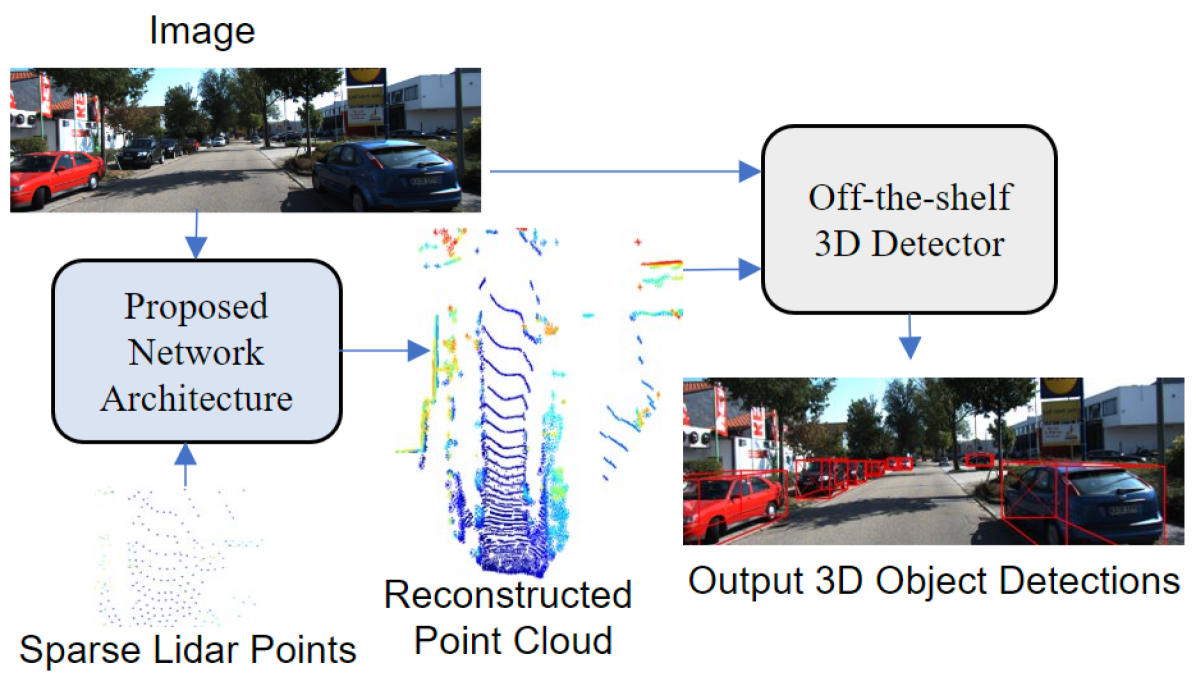
Sparse Points to Dense Clouds: Enhancing 3D Detection with Limited LiDAR Data
Aakash Kumar, Chen Chen, Ajmal Mian, Neils Lobo, Mubarak Shah
3D detection is a critical task that enables machines to identify and locate objects in three-dimensional space. It has a broad range of applications in several fields, including autonomous driving, robotics and augmented reality. Monocular 3D detection is attractive as it requires only a single camera, however, it lacks the accuracy and robustness required for real world applications. High resolution LiDAR on the other hand, can be expensive and lead to interference problems in heavy traffic given their active transmissions. We propose a balanced approach that combines the advantages of monocular and point cloud-based 3D detection. Our method requires only a small number of 3D points, that can be obtained from a low-cost, low-resolution sensor. Specifically, we use only 512 points, which is just 1% of a full LiDAR frame in the KITTI dataset. Our method reconstructs a complete 3D point cloud from this limited 3D information combined with a single image. The reconstructed 3D point cloud and corresponding image can be used by any multi-modal off-the-shelf detector for 3D object detection. By using the proposed network architecture with an off-the-shelf multi-modal 3D detector, the accuracy of 3D detection improves by 20% compared to the state-of-the-art monocular detection methods and 6% to 9% compare to the baseline multi-modal methods on KITTI and JackRabbot datasets.
Read more4/11/2024

0
LVCP: LiDAR-Vision Tightly Coupled Collaborative Real-time Relative Positioning
Zhuozhu Jian, Qixuan Li, Shengtao Zheng, Xueqian Wang, Xinlei Chen
In air-ground collaboration scenarios without GPS and prior maps, the relative positioning of drones and unmanned ground vehicles (UGVs) has always been a challenge. For a drone equipped with monocular camera and an UGV equipped with LiDAR as an external sensor, we propose a robust and real-time relative pose estimation method (LVCP) based on the tight coupling of vision and LiDAR point cloud information, which does not require prior information such as maps or precise initial poses. Given that large-scale point clouds generated by 3D sensors has more accurate spatial geometric information than the feature point cloud generated by image, we utilize LiDAR point clouds to correct the drift in visual-inertial odometry (VIO) when the camera undergoes significant shaking or the IMU has a low signal-to-noise ratio. To achieve this, we propose a novel coarse-to-fine framework for LiDAR-vision collaborative localization. In this framework, we construct point-plane association based on spatial geometric information, and innovatively construct a point-aided Bundle Adjustment (BA) problem as the backend to simultaneously estimate the relative pose of the camera and LiDAR and correct the VIO drift. In this process, we propose a particle swarm optimization (PSO) based sampling algorithm to complete the coarse estimation of the current camera-LiDAR pose. In this process, the initial pose of the camera used for sampling is obtained based on VIO propagation, and the valid feature-plane association number (VFPN) is used to trigger PSO-sampling process. Additionally, we propose a method that combines Structure from Motion (SFM) and multi-level sampling to initialize the algorithm, addressing the challenge of lacking initial values.
Read more7/16/2024