Towards Natural Language-Guided Drones: GeoText-1652 Benchmark with Spatial Relation Matching

0
🌿
Sign in to get full access
Overview
- This paper introduces a new natural language-guided geo-localization benchmark called GeoText-1652.
- The dataset is constructed through an interactive human-computer process using Large Language Model (LLM) driven annotation techniques and pre-trained vision models.
- The dataset extends the established University-1652 image dataset with spatial-aware text annotations, creating one-to-one correspondences between image, text, and bounding box elements.
- The paper also introduces a new optimization objective called "blending spatial matching" to leverage fine-grained spatial associations for region-level spatial relation matching.
Plain English Explanation
Controlling and navigating drones using natural language commands remains a challenging task. This is largely due to the lack of accessible multi-modal datasets that align visual and textual data, as well as the strict precision requirements for such alignment.
To address this issue, the researchers created a new dataset called GeoText-1652. This dataset was systematically constructed through an interactive process that leveraged Large Language Models (LLMs) and pre-trained vision models to annotate images with spatial-aware text. This means that the text descriptions are closely tied to specific regions within the images, creating a one-to-one correspondence between the image, text, and the location being described.
The researchers also introduced a new optimization technique called "blending spatial matching" that helps the model better understand the spatial relationships between different elements in the image and text. This is important for enabling drones to follow natural language commands that refer to specific locations or objects in the environment.
Experiments showed that this approach maintains a competitive performance compared to other cross-modal methods, suggesting that it has promising potential for improving drone control and navigation through the seamless integration of natural language commands in real-world scenarios.
Technical Explanation
The paper addresses the challenge of navigating drones through natural language commands, which is hindered by the lack of accessible multi-modal datasets and the stringent precision requirements for aligning visual and textual data. To tackle this issue, the researchers introduce GeoText-1652, a new natural language-guided geo-localization benchmark.
This dataset is systematically constructed through an interactive human-computer process, leveraging Large Language Model (LLM) driven annotation techniques in conjunction with pre-trained vision models. GeoText-1652 extends the established University-1652 image dataset with spatial-aware text annotations, thereby establishing one-to-one correspondences between image, text, and bounding box elements.
Furthermore, the researchers introduce a new optimization objective called "blending spatial matching" to leverage fine-grained spatial associations for region-level spatial relation matching. This approach aims to enhance the model's understanding of the spatial relationships between different elements in the image and text, which is crucial for enabling drones to follow natural language commands that refer to specific locations or objects in the environment.
Extensive experiments reveal that the proposed approach maintains a competitive recall rate compared to other prevailing cross-modality methods, underscoring the promising potential of this approach in elevating drone control and navigation through the seamless integration of natural language commands in real-world scenarios.
Critical Analysis
The paper provides a valuable contribution to the field of natural language-guided drone navigation, addressing a pressing need for accessible multi-modal datasets and effective techniques for aligning visual and textual data. The systematic construction of the GeoText-1652 dataset through interactive human-computer processes and the use of LLM-driven annotation techniques are promising steps towards overcoming the limited availability of such resources.
However, the paper does not provide a thorough discussion of the limitations and potential biases inherent in the dataset construction process. For example, the role of human annotators and the potential for subjective interpretations or inconsistencies in the text-image alignments could be explored in more depth. Additionally, the paper does not address potential issues with the scalability and generalizability of the proposed approach, as the dataset is relatively small compared to the vast diversity of real-world environments and natural language commands.
Furthermore, the paper could have delved deeper into the evaluation of the "blending spatial matching" optimization objective, providing more detailed insights into its performance and potential trade-offs compared to other cross-modal matching techniques. A more comprehensive analysis of the model's strengths, weaknesses, and areas for further improvement would strengthen the critical understanding of the proposed approach.
Conclusion
This paper introduces a valuable new dataset, GeoText-1652, which addresses the challenge of navigating drones through natural language commands. By creating a dataset with one-to-one correspondences between images, text, and bounding box elements, the researchers have taken an important step towards bridging the gap between visual and textual data for drone control and navigation.
The proposed "blending spatial matching" optimization objective also shows promise in enhancing the model's understanding of spatial relationships, which is crucial for enabling drones to follow natural language commands that refer to specific locations or objects in the environment. While the paper provides encouraging results, further research is needed to address the potential limitations and explore ways to scale the approach for more diverse real-world scenarios.
Overall, this work represents a significant contribution to the field of drone control and navigation, and its findings may have broader implications for the integration of natural language commands in various robotics and automation applications.
This summary was produced with help from an AI and may contain inaccuracies - check out the links to read the original source documents!
Related Papers
🌿
0
Towards Natural Language-Guided Drones: GeoText-1652 Benchmark with Spatial Relation Matching
Meng Chu, Zhedong Zheng, Wei Ji, Tingyu Wang, Tat-Seng Chua
Navigating drones through natural language commands remains challenging due to the dearth of accessible multi-modal datasets and the stringent precision requirements for aligning visual and textual data. To address this pressing need, we introduce GeoText-1652, a new natural language-guided geo-localization benchmark. This dataset is systematically constructed through an interactive human-computer process leveraging Large Language Model (LLM) driven annotation techniques in conjunction with pre-trained vision models. GeoText-1652 extends the established University-1652 image dataset with spatial-aware text annotations, thereby establishing one-to-one correspondences between image, text, and bounding box elements. We further introduce a new optimization objective to leverage fine-grained spatial associations, called blending spatial matching, for region-level spatial relation matching. Extensive experiments reveal that our approach maintains a competitive recall rate comparing other prevailing cross-modality methods. This underscores the promising potential of our approach in elevating drone control and navigation through the seamless integration of natural language commands in real-world scenarios.
Read more8/1/2024
0
LLMGeo: Benchmarking Large Language Models on Image Geolocation In-the-wild
Zhiqiang Wang, Dejia Xu, Rana Muhammad Shahroz Khan, Yanbin Lin, Zhiwen Fan, Xingquan Zhu
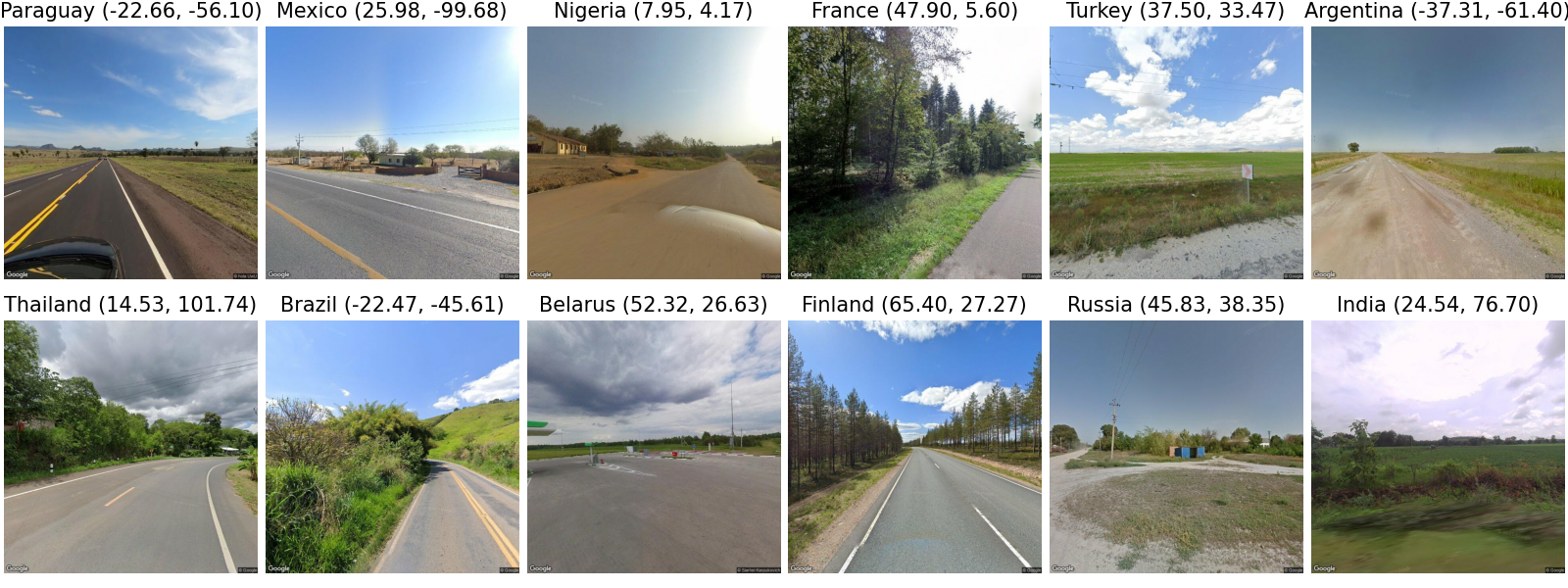
Image geolocation is a critical task in various image-understanding applications. However, existing methods often fail when analyzing challenging, in-the-wild images. Inspired by the exceptional background knowledge of multimodal language models, we systematically evaluate their geolocation capabilities using a novel image dataset and a comprehensive evaluation framework. We first collect images from various countries via Google Street View. Then, we conduct training-free and training-based evaluations on closed-source and open-source multi-modal language models. we conduct both training-free and training-based evaluations on closed-source and open-source multimodal language models. Our findings indicate that closed-source models demonstrate superior geolocation abilities, while open-source models can achieve comparable performance through fine-tuning.
Read more6/3/2024
0
Into the Unknown: Generating Geospatial Descriptions for New Environments
Tzuf Paz-Argaman, John Palowitch, Sayali Kulkarni, Reut Tsarfaty, Jason Baldridge
Similar to vision-and-language navigation (VLN) tasks that focus on bridging the gap between vision and language for embodied navigation, the new Rendezvous (RVS) task requires reasoning over allocentric spatial relationships (independent of the observer's viewpoint) using non-sequential navigation instructions and maps. However, performance substantially drops in new environments with no training data. Using opensource descriptions paired with coordinates (e.g., Wikipedia) provides training data but suffers from limited spatially-oriented text resulting in low geolocation resolution. We propose a large-scale augmentation method for generating high-quality synthetic data for new environments using readily available geospatial data. Our method constructs a grounded knowledge-graph, capturing entity relationships. Sampled entities and relations (`shop north of school') generate navigation instructions via (i) generating numerous templates using context-free grammar (CFG) to embed specific entities and relations; (ii) feeding the entities and relation into a large language model (LLM) for instruction generation. A comprehensive evaluation on RVS, showed that our approach improves the 100-meter accuracy by 45.83% on unseen environments. Furthermore, we demonstrate that models trained with CFG-based augmentation achieve superior performance compared with those trained with LLM-based augmentation, both in unseen and seen environments. These findings suggest that the potential advantages of explicitly structuring spatial information for text-based geospatial reasoning in previously unknown, can unlock data-scarce scenarios.
Read more7/1/2024
🎯
0
Evaluating Tool-Augmented Agents in Remote Sensing Platforms
Simranjit Singh, Michael Fore, Dimitrios Stamoulis
Tool-augmented Large Language Models (LLMs) have shown impressive capabilities in remote sensing (RS) applications. However, existing benchmarks assume question-answering input templates over predefined image-text data pairs. These standalone instructions neglect the intricacies of realistic user-grounded tasks. Consider a geospatial analyst: they zoom in a map area, they draw a region over which to collect satellite imagery, and they succinctly ask Detect all objects here. Where is `here`, if it is not explicitly hardcoded in the image-text template, but instead is implied by the system state, e.g., the live map positioning? To bridge this gap, we present GeoLLM-QA, a benchmark designed to capture long sequences of verbal, visual, and click-based actions on a real UI platform. Through in-depth evaluation of state-of-the-art LLMs over a diverse set of 1,000 tasks, we offer insights towards stronger agents for RS applications.
Read more5/3/2024