Arctic Sea Ice Image Super-Resolution Based on Multi-Scale Convolution and Dual-Gating Mechanism

0
Sign in to get full access
Overview
- This paper presents a novel approach for enhancing the resolution of Arctic sea ice images using a deep learning model.
- The key innovations include a multi-scale convolutional network and a dual-gating mechanism that leverages both local and global information.
- The proposed method aims to produce high-quality, super-resolved sea ice images from low-resolution inputs, which is important for various applications in climate research and monitoring.
Plain English Explanation
The paper focuses on a problem called "super-resolution" - the task of taking a low-quality, low-resolution image and turning it into a higher-quality, higher-resolution version. This is particularly important for studying Arctic sea ice, where satellite images may not always have the best resolution.
The researchers developed a deep learning model that uses a multi-scale approach to capture both local details and broader, global patterns in the sea ice. It has a "dual-gating" mechanism that allows the model to selectively emphasize the most relevant information at different scales.
By combining these techniques, the model is able to produce high-resolution sea ice images that are more accurate and detailed than the original low-resolution inputs. This can be very helpful for climate researchers and others who need to closely monitor changes in Arctic sea ice over time.
The key innovation is this multi-scale, dual-gating architecture that allows the model to adaptively focus on the most important features at different scales. This helps it generate super-resolved images that are closer to the real, high-resolution scenes.
Technical Explanation
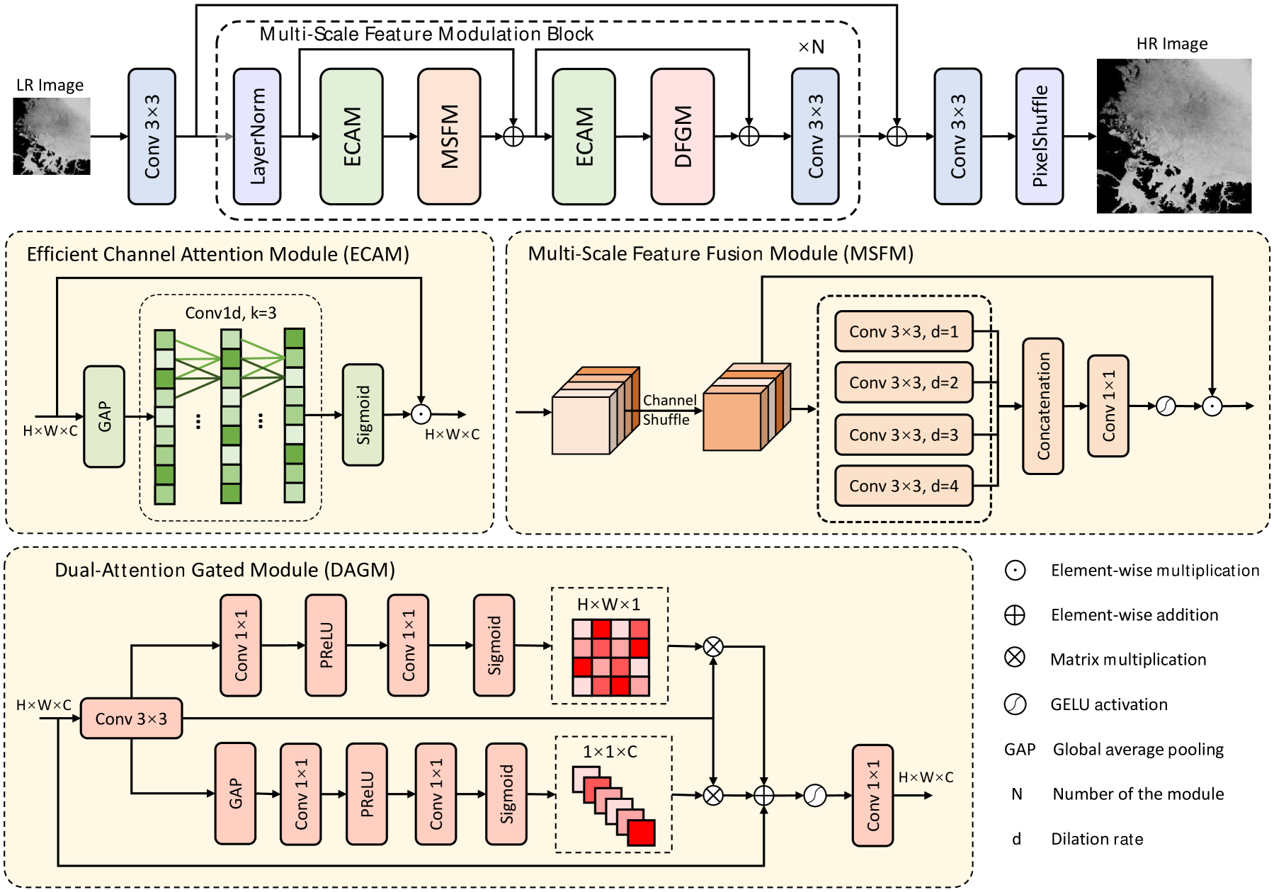
The proposed method, called DGSM-Net, uses a multi-scale convolutional network with a dual-gating mechanism to perform Arctic sea ice image super-resolution.
The multi-scale component captures features at different resolutions, allowing the model to incorporate both local details and global context. The dual-gating mechanism then selectively emphasizes the most relevant information at each scale, using both channel-wise and spatial attention.
This architecture is built on top of a backbone feature extractor that processes the low-resolution input. The super-resolution module then upscales the features using a cross-sensor approach and a transformer-based fusion of local and global information.
The model is trained end-to-end using a combination of reconstruction, perceptual, and adversarial loss functions. This allows it to generate visually appealing, high-resolution sea ice images that capture important mesoscale details.
Critical Analysis
The paper presents a comprehensive and well-designed approach to Arctic sea ice super-resolution. The multi-scale and dual-gating innovations appear to be effective at leveraging both local and global information to produce high-quality results.
However, the authors acknowledge that their method has some limitations. For example, it may not perform as well on certain types of ice formations or in regions with significant cloud cover. Additionally, the computational cost of the model could be prohibitive for some real-time applications.
Further research could explore ways to improve the model's robustness and efficiency, such as by incorporating additional contextual information (e.g., weather data, ice chart annotations) or by exploring more lightweight network architectures. Validation on a broader range of sea ice conditions would also help assess the generalizability of the approach.
Overall, this paper makes a valuable contribution to the field of Arctic remote sensing and climate monitoring by demonstrating the potential of deep learning-based super-resolution to enhance the quality and utility of sea ice imagery.
Conclusion
The proposed DGSM-Net model represents a significant advancement in the field of Arctic sea ice image super-resolution. By leveraging a multi-scale convolutional network and a dual-gating mechanism, the method is able to generate high-resolution, visually appealing sea ice images from low-resolution inputs.
This technology has important implications for climate research, environmental monitoring, and various other applications that rely on accurate and detailed sea ice data. The authors have demonstrated the effectiveness of their approach through extensive experiments and comparisons to state-of-the-art methods.
While the model has some limitations, the core innovations presented in this paper lay the groundwork for future improvements and adaptations. As the field of Arctic remote sensing continues to evolve, techniques like those developed in this work will play an increasingly crucial role in our understanding and stewardship of this critical region.
This summary was produced with help from an AI and may contain inaccuracies - check out the links to read the original source documents!
Related Papers
0
Arctic Sea Ice Image Super-Resolution Based on Multi-Scale Convolution and Dual-Gating Mechanism
Zhaomin Fang, Wankun Chen, Feng Gao, Yanhai Gan, Junyu Dong, Yang Zhou
Arctic Sea Ice Concentration (SIC) is the ratio of ice-covered area to the total sea area of the Arctic Ocean, which is a key indicator for maritime activities. Nowadays, we often use passive microwave images to display SIC, but it has low spatial resolution, and most of the existing super-resolution methods of Arctic SIC don't take the integration of spatial and channel features into account and can't effectively integrate the multi-scale feature. To overcome the aforementioned issues, we propose MFM-Net for Arctic SIC super-resolution, which concurrently aggregates multi-scale information while integrating spatial and channel features. Extensive experiments on Arctic SIC dataset from the AMSR-E/AMSR-2 SIC DT-ASI products from Ocean University of China validate the effectiveness of porposed MFM-Net.
Read more6/4/2024

0
Region-level labels in ice charts can produce pixel-level segmentation for Sea Ice types
Muhammed Patel, Xinwei Chen, Linlin Xu, Yuhao Chen, K Andrea Scott, David A. Clausi
Fully supervised deep learning approaches have demonstrated impressive accuracy in sea ice classification, but their dependence on high-resolution labels presents a significant challenge due to the difficulty of obtaining such data. In response, our weakly supervised learning method provides a compelling alternative by utilizing lower-resolution regional labels from expert-annotated ice charts. This approach achieves exceptional pixel-level classification performance by introducing regional loss representations during training to measure the disparity between predicted and ice chart-derived sea ice type distributions. Leveraging the AI4Arctic Sea Ice Challenge Dataset, our method outperforms the fully supervised U-Net benchmark, the top solution of the AutoIce challenge, in both mapping resolution and class-wise accuracy, marking a significant advancement in automated operational sea ice mapping.
Read more5/20/2024
🏷️
0
Partial Label Learning with Focal Loss for Sea Ice Classification Based on Ice Charts
Behzad Vahedi, Benjamin Lucas, Farnoush Banaei-Kashani, Andrew P. Barrett, Walter N. Meier, Siri Jodha Khalsa, Morteza Karimzadeh
Sea ice, crucial to the Arctic and Earth's climate, requires consistent monitoring and high-resolution mapping. Manual sea ice mapping, however, is time-consuming and subjective, prompting the need for automated deep learning-based classification approaches. However, training these algorithms is challenging because expert-generated ice charts, commonly used as training data, do not map single ice types but instead map polygons with multiple ice types. Moreover, the distribution of various ice types in these charts is frequently imbalanced, resulting in a performance bias towards the dominant class. In this paper, we present a novel GeoAI approach to training sea ice classification by formalizing it as a partial label learning task with explicit confidence scores to address multiple labels and class imbalance. We treat the polygon-level labels as candidate partial labels, assign the corresponding ice concentrations as confidence scores to each candidate label, and integrate them with focal loss to train a Convolutional Neural Network (CNN). Our proposed approach leads to enhanced performance for sea ice classification in Sentinel-1 dual-polarized SAR images, improving classification accuracy (from 87% to 92%) and weighted average F-1 score (from 90% to 93%) compared to the conventional training approach of using one-hot encoded labels and Categorical Cross-Entropy loss. It also improves the F-1 score in 4 out of the 6 sea ice classes.
Read more6/11/2024
0
Super-Resolution works for coastal simulations
Zhi-Song Liu, Markus Buttner, Vadym Aizinger, Andreas Rupp
Learning fine-scale details of a coastal ocean simulation from a coarse representation is a challenging task. For real-world applications, high-resolution simulations are necessary to advance understanding of many coastal processes, specifically, to predict flooding resulting from tsunamis and storm surges. We propose a Deep Network for Coastal Super-Resolution (DNCSR) for spatiotemporal enhancement to efficiently learn the high-resolution numerical solution. Given images of coastal simulations produced on low-resolution computational meshes using low polynomial order discontinuous Galerkin discretizations and a coarse temporal resolution, the proposed DNCSR learns to produce high-resolution free surface elevation and velocity visualizations in both time and space. To efficiently model the dynamic changes over time and space, we propose grid-aware spatiotemporal attention to project the temporal features to the spatial domain for non-local feature matching. The coordinate information is also utilized via positional encoding. For the final reconstruction, we use the spatiotemporal bilinear operation to interpolate the missing frames and then expand the feature maps to the frequency domain for residual mapping. Besides data-driven losses, the proposed physics-informed loss guarantees gradient consistency and momentum changes. Their combination contributes to the overall 24% improvements in RMSE. To train the proposed model, we propose a large-scale coastal simulation dataset and use it for model optimization and evaluation. Our method shows superior super-resolution quality and fast computation compared to the state-of-the-art methods.
Read more8/30/2024