Brightearth roads: Towards fully automatic road network extraction from satellite imagery
2406.14941
0
0
🌐
Abstract
The modern road network topology comprises intricately designed structures that introduce complexity when automatically reconstructing road networks. While open resources like OpenStreetMap (OSM) offer road networks with well-defined topology, they may not always be up to date worldwide. In this paper, we propose a fully automated pipeline for extracting road networks from very-high-resolution (VHR) satellite imagery. Our approach directly generates road line-strings that are seamlessly connected and precisely positioned. The process involves three key modules: a CNN-based neural network for road segmentation, a graph optimization algorithm to convert road predictions into vector line-strings, and a machine learning model for classifying road materials. Compared to OSM data, our results demonstrate significant potential for providing the latest road layouts and precise positions of road segments.
Create account to get full access
Overview
- Automatically reconstructing road networks from satellite imagery is a complex task due to the intricate design of modern road networks.
- While OpenStreetMap (OSM) provides detailed road network data, it may not always be up-to-date globally.
- This paper presents a fully automated pipeline for extracting road networks directly from very-high-resolution (VHR) satellite imagery.
- The approach generates seamlessly connected and precisely positioned road line-strings using three key modules: a CNN-based road segmentation model, a graph optimization algorithm, and a machine learning model for road material classification.
Plain English Explanation
Roads are an essential part of our transportation infrastructure, but automatically mapping them from satellite images can be challenging. The modern road network is designed with many intricate features, which makes it difficult to reconstruct accurately. While open data sources like OpenStreetMap provide detailed road network information, this data may not always be up-to-date, especially in some parts of the world.
To address this, the researchers in this paper have developed a fully automated system that can directly extract road networks from high-resolution satellite imagery. Their approach generates road "line-strings" - digital representations of the roads - that are seamlessly connected and precisely positioned. This is achieved through three key steps:
- A convolutional neural network (CNN) is used to identify and segment the roads in the satellite images.
- A graph optimization algorithm is then used to convert these road predictions into the final vector line-strings.
- A machine learning model is employed to classify the material type of the roads (e.g., asphalt, concrete).
Compared to the data from OpenStreetMap, the researchers found that their automated system can provide more up-to-date and accurate representations of road layouts and positions. This could be particularly useful for applications like collaborative road extraction or automated generation of driving maps.
Technical Explanation
The researchers propose a fully automated pipeline for extracting road networks directly from very-high-resolution (VHR) satellite imagery. Their approach generates seamlessly connected and precisely positioned road line-strings through three key modules:
-
Road Segmentation: A convolutional neural network (CNN) is used to identify and segment the roads within the satellite images. This CNN-based model is trained to classify each pixel as either "road" or "non-road".
-
Graph Optimization: The road predictions from the segmentation model are then converted into vector line-strings using a graph optimization algorithm. This algorithm constructs a graph representation of the roads and optimizes it to produce the final road network.
-
Road Material Classification: A separate machine learning model is employed to classify the material type (e.g., asphalt, concrete) of the identified road segments. This information can be useful for applications like road maintenance and planning.
Compared to the road network data available from OpenStreetMap, the researchers found that their automated system can provide more up-to-date and accurate representations of road layouts and positions. This is particularly important in regions where OSM data may be incomplete or outdated.
Critical Analysis
The researchers acknowledge several caveats and limitations in their work. For example, the performance of the road segmentation model may be affected by factors like varying image resolutions, shadows, and occlusions from buildings or vegetation. Additionally, the graph optimization algorithm relies on certain assumptions about road connectivity and geometry that may not always hold true in the real world.
Furthermore, the road material classification model is trained on a relatively small dataset, which could limit its generalization to a wider range of road types and environmental conditions. The researchers suggest that expanding the training data and exploring more advanced classification techniques could help improve the model's performance.
It's also worth noting that the proposed pipeline is fully automated, which means that human oversight and validation may be necessary to ensure the accuracy and reliability of the extracted road networks, especially in critical applications.
Conclusion
This research presents a promising approach for automatically extracting detailed and up-to-date road network information from satellite imagery. By combining advanced computer vision techniques, graph optimization, and machine learning, the researchers have developed a comprehensive pipeline that can generate seamlessly connected and precisely positioned road line-strings.
The potential benefits of this technology are significant, particularly for applications that require accurate and timely road network data, such as transportation planning, emergency response, and autonomous vehicle navigation. As the researchers continue to refine and scale their approach, it could become an invaluable tool for maintaining and improving our global transportation infrastructure.
This summary was produced with help from an AI and may contain inaccuracies - check out the links to read the original source documents!
Related Papers
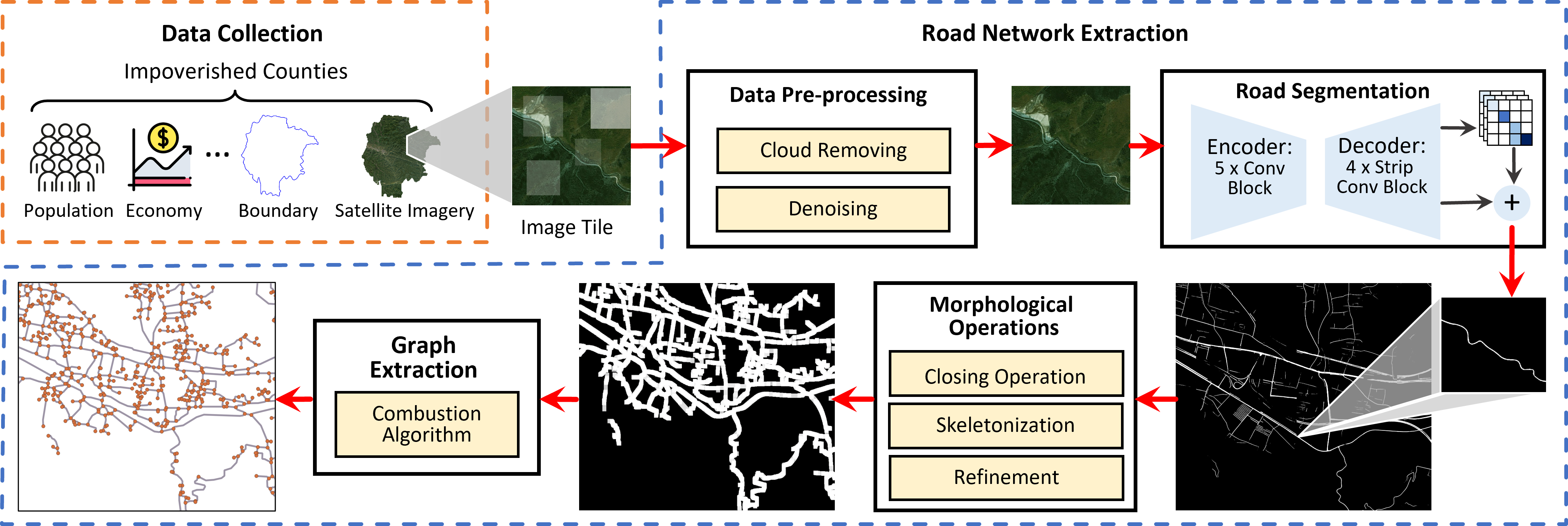
From Pixels to Progress: Generating Road Network from Satellite Imagery for Socioeconomic Insights in Impoverished Areas
Yanxin Xi, Yu Liu, Zhicheng Liu, Sasu Tarkoma, Pan Hui, Yong Li
0
0
The Sustainable Development Goals (SDGs) aim to resolve societal challenges, such as eradicating poverty and improving the lives of vulnerable populations in impoverished areas. Those areas rely on road infrastructure construction to promote accessibility and economic development. Although publicly available data like OpenStreetMap is available to monitor road status, data completeness in impoverished areas is limited. Meanwhile, the development of deep learning techniques and satellite imagery shows excellent potential for earth monitoring. To tackle the challenge of road network assessment in impoverished areas, we develop a systematic road extraction framework combining an encoder-decoder architecture and morphological operations on satellite imagery, offering an integrated workflow for interdisciplinary researchers. Extensive experiments of road network extraction on real-world data in impoverished regions achieve a 42.7% enhancement in the F1-score over the baseline methods and reconstruct about 80% of the actual roads. We also propose a comprehensive road network dataset covering approximately 794,178 km2 area and 17.048 million people in 382 impoverished counties in China. The generated dataset is further utilized to conduct socioeconomic analysis in impoverished counties, showing that road network construction positively impacts regional economic development. The technical appendix, code, and generated dataset can be found at https://github.com/tsinghua-fib-lab/Road_network_extraction_impoverished_counties.
6/18/2024
Automated National Urban Map Extraction
Hasan Nasrallah, Abed Ellatif Samhat, Cristiano Nattero, Ali J. Ghandour
0
0
Developing countries usually lack the proper governance means to generate and regularly update a national rooftop map. Using traditional photogrammetry and surveying methods to produce a building map at the federal level is costly and time consuming. Using earth observation and deep learning methods, we can bridge this gap and propose an automated pipeline to fetch such national urban maps. This paper aims to exploit the power of fully convolutional neural networks for multi-class buildings' instance segmentation to leverage high object-wise accuracy results. Buildings' instance segmentation from sub-meter high-resolution satellite images can be achieved with relatively high pixel-wise metric scores. We detail all engineering steps to replicate this work and ensure highly accurate results in dense and slum areas witnessed in regions that lack proper urban planning in the Global South. We applied a case study of the proposed pipeline to Lebanon and successfully produced the first comprehensive national building footprint map with approximately 1 Million units with an 84% accuracy. The proposed architecture relies on advanced augmentation techniques to overcome dataset scarcity, which is often the case in developing countries.
5/6/2024
📈
Computer vision-based model for detecting turning lane features on Florida's public roadways
Richard Boadu Antwi, Samuel Takyi, Kimollo Michael, Alican Karaer, Eren Erman Ozguven, Ren Moses, Maxim A. Dulebenets, Thobias Sando
0
0
Efficient and current roadway geometry data collection is critical to transportation agencies in road planning, maintenance, design, and rehabilitation. Data collection methods are divided into land-based and aerial-based. Land-based methods for extensive highway networks are tedious, costly, pose safety risks. Therefore, there is the need for efficient, safe, and economical data acquisition methodologies. The rise of computer vision and object detection technologies have made automated extraction of roadway geometry features feasible. This study detects roadway features on Florida's public roads from high-resolution aerial images using AI. The developed model achieved an average accuracy of 80.4 percent when compared with ground truth data. The extracted roadway geometry data can be integrated with crash and traffic data to provide valuable insights to policymakers and roadway users.
6/14/2024
⛏️
Building-road Collaborative Extraction from Remotely Sensed Images via Cross-Interaction
Haonan Guo, Xin Su, Chen Wu, Bo Du, Liangpei Zhang
0
0
Buildings are the basic carrier of social production and human life; roads are the links that interconnect social networks. Building and road information has important application value in the frontier fields of regional coordinated development, disaster prevention, auto-driving, etc. Mapping buildings and roads from very high-resolution (VHR) remote sensing images have become a hot research topic. However, the existing methods often ignore the strong spatial correlation between roads and buildings and extract them in isolation. To fully utilize the complementary advantages between buildings and roads, we propose a building-road collaborative extraction method based on multi-task and cross-scale feature interaction to improve the accuracy of both tasks in a complementary way. A multi-task interaction module is proposed to interact information across tasks and preserve the unique information of each task, which tackle the seesaw phenomenon in multitask learning. By considering the variation in appearance and structure between buildings and roads, a cross-scale interaction module is designed to automatically learn the optimal reception field for different tasks. Compared with many existing methods that train each task individually, the proposed collaborative extraction method can utilize the complementary advantages between buildings and roads by the proposed inter-task and inter-scale feature interactions, and automatically select the optimal reception field for different tasks. Experiments on a wide range of urban and rural scenarios show that the proposed algorithm can achieve building-road extraction with outstanding performance and efficiency.
4/11/2024