From Pixels to Progress: Generating Road Network from Satellite Imagery for Socioeconomic Insights in Impoverished Areas
2406.11282
0
0
Abstract
The Sustainable Development Goals (SDGs) aim to resolve societal challenges, such as eradicating poverty and improving the lives of vulnerable populations in impoverished areas. Those areas rely on road infrastructure construction to promote accessibility and economic development. Although publicly available data like OpenStreetMap is available to monitor road status, data completeness in impoverished areas is limited. Meanwhile, the development of deep learning techniques and satellite imagery shows excellent potential for earth monitoring. To tackle the challenge of road network assessment in impoverished areas, we develop a systematic road extraction framework combining an encoder-decoder architecture and morphological operations on satellite imagery, offering an integrated workflow for interdisciplinary researchers. Extensive experiments of road network extraction on real-world data in impoverished regions achieve a 42.7% enhancement in the F1-score over the baseline methods and reconstruct about 80% of the actual roads. We also propose a comprehensive road network dataset covering approximately 794,178 km2 area and 17.048 million people in 382 impoverished counties in China. The generated dataset is further utilized to conduct socioeconomic analysis in impoverished counties, showing that road network construction positively impacts regional economic development. The technical appendix, code, and generated dataset can be found at https://github.com/tsinghua-fib-lab/Road_network_extraction_impoverished_counties.
Create account to get full access
Overview
- This paper presents a method for generating detailed road networks from satellite imagery, with a focus on applications in impoverished areas.
- The approach uses deep learning techniques to automatically detect and extract road features from high-resolution satellite images.
- The generated road maps can provide valuable socioeconomic insights, such as identifying areas with limited infrastructure and accessibility.
Plain English Explanation
The researchers in this study developed a way to create detailed maps of road networks using satellite images. This is particularly useful for understanding infrastructure and accessibility in poor or underserved communities.
By applying advanced deep learning algorithms to high-quality satellite data, the researchers were able to automatically detect and extract the locations of roads. This allows them to generate comprehensive road maps without the need for extensive manual labor or on-the-ground surveys.
These detailed road maps can provide important insights about the socioeconomic conditions in an area. For example, the maps can reveal which neighborhoods have fewer roads and transportation options, indicating a lack of basic infrastructure and potentially limited economic opportunities. This information can then be used by policymakers, aid organizations, and urban planners to better target resources and development efforts.
Overall, this research demonstrates how cutting-edge artificial intelligence techniques can be leveraged to gain a deeper understanding of the built environment and socioeconomic factors in impoverished regions, with the potential to inform more effective interventions and improve people's lives.
Technical Explanation
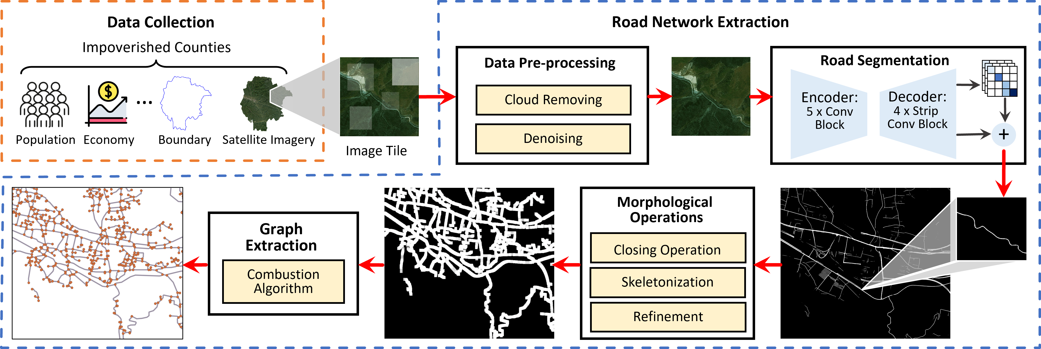
The paper presents a method for generating road networks from satellite imagery to enable socioeconomic insights in impoverished areas. The approach uses deep learning models to automatically detect and extract road features from high-resolution satellite images.
The researchers developed a two-stage pipeline. First, a road segmentation model is used to identify pixels corresponding to roads in the satellite imagery. This model is trained on a large dataset of annotated road maps. Second, a road vectorization module converts the segmented road pixels into a vector-based road network representation, including the connectivity and topology of the roads.
The generated road maps are then used to derive various socioeconomic indicators, such as road density, accessibility, and connectivity. These insights can be valuable for understanding infrastructure deficits and informing development efforts in underserved communities.
The researchers evaluated their approach on several benchmark datasets of satellite imagery covering impoverished regions. The results demonstrate the ability to accurately extract road networks, outperforming previous state-of-the-art methods. Additionally, the paper presents case studies highlighting how the derived road maps can provide actionable socioeconomic insights.
Critical Analysis
The paper makes a compelling case for the value of automated road network extraction from satellite imagery, particularly in the context of understanding and addressing challenges in impoverished areas. The technical approach seems well-designed and the experimental results are promising.
One potential limitation is the reliance on high-resolution satellite data, which may not be readily available or affordable in all regions of interest. The authors mention the need for further research to adapt the models to work with lower-quality or lower-resolution imagery, which would expand the accessibility and scalability of the approach.
Additionally, while the paper focuses on deriving socioeconomic insights from the generated road maps, it does not provide a comprehensive evaluation of the accuracy or reliability of these insights. Further validation and comparison to ground-truth data would help strengthen the claims about the practical utility of the approach for informing real-world development and policy decisions.
It would also be valuable to see more discussion of potential ethical considerations, such as the use of such technology to monitor or surveil marginalized communities, or the risk of unintended consequences from the misinterpretation or misuse of the derived insights.
Overall, this research represents an important step forward in leveraging remote sensing and computer vision techniques to generate actionable data for socioeconomic development. Addressing the limitations and ethical considerations mentioned could further strengthen the impact and responsible application of this work.
Conclusion
This paper introduces a novel method for automatically generating detailed road networks from satellite imagery, with a focus on applications in impoverished areas. By combining advanced deep learning techniques with high-resolution satellite data, the researchers were able to accurately extract road features and derive valuable socioeconomic insights, such as identifying infrastructure deficits and accessibility challenges.
The generated road maps have the potential to inform more effective development efforts and resource allocation in underserved communities. This research demonstrates the power of integrating artificial intelligence with remote sensing data to gain a deeper understanding of the built environment and socioeconomic factors, ultimately working towards the goal of improving people's lives.
This summary was produced with help from an AI and may contain inaccuracies - check out the links to read the original source documents!
Related Papers
🌐
Brightearth roads: Towards fully automatic road network extraction from satellite imagery
Liuyun Duan (LCT), Willard Mapurisa (LCT), Maxime Leras (LCT), Leigh Lotter (LCT), Yuliya Tarabalka (LCT)
0
0
The modern road network topology comprises intricately designed structures that introduce complexity when automatically reconstructing road networks. While open resources like OpenStreetMap (OSM) offer road networks with well-defined topology, they may not always be up to date worldwide. In this paper, we propose a fully automated pipeline for extracting road networks from very-high-resolution (VHR) satellite imagery. Our approach directly generates road line-strings that are seamlessly connected and precisely positioned. The process involves three key modules: a CNN-based neural network for road segmentation, a graph optimization algorithm to convert road predictions into vector line-strings, and a machine learning model for classifying road materials. Compared to OSM data, our results demonstrate significant potential for providing the latest road layouts and precise positions of road segments.
6/24/2024

Deep Learning for Slum Mapping in Remote Sensing Images: A Meta-analysis and Review
Anjali Raj, Adway Mitra, Manjira Sinha
0
0
The major Sustainable Development Goals (SDG) 2030, set by the United Nations Development Program (UNDP), include sustainable cities and communities, no poverty, and reduced inequalities. However, millions of people live in slums or informal settlements with poor living conditions in many major cities around the world, especially in less developed countries. To emancipate these settlements and their inhabitants through government intervention, accurate data about slum location and extent is required. While ground survey data is the most reliable, such surveys are costly and time-consuming. An alternative is remotely sensed data obtained from very high-resolution (VHR) imagery. With the advancement of new technology, remote sensing based mapping of slums has emerged as a prominent research area. The parallel rise of Artificial Intelligence, especially Deep Learning has added a new dimension to this field as it allows automated analysis of satellite imagery to identify complex spatial patterns associated with slums. This article offers a detailed review and meta-analysis of research on slum mapping using remote sensing imagery from 2014 to 2024, with a special focus on deep learning approaches. Our analysis reveals a trend towards increasingly complex neural network architectures, with advancements in data preprocessing and model training techniques significantly enhancing slum identification accuracy. We have attempted to identify key methodologies that are effective across diverse geographic contexts. While acknowledging the transformative impact Convolutional Neural Networks (CNNs) in slum detection, our review underscores the absence of a universally optimal model, suggesting the need for context-specific adaptations. We also identify prevailing challenges in this field, such as data limitations and a lack of model explainability and suggest potential strategies for overcoming these.
6/13/2024
Automated National Urban Map Extraction
Hasan Nasrallah, Abed Ellatif Samhat, Cristiano Nattero, Ali J. Ghandour
0
0
Developing countries usually lack the proper governance means to generate and regularly update a national rooftop map. Using traditional photogrammetry and surveying methods to produce a building map at the federal level is costly and time consuming. Using earth observation and deep learning methods, we can bridge this gap and propose an automated pipeline to fetch such national urban maps. This paper aims to exploit the power of fully convolutional neural networks for multi-class buildings' instance segmentation to leverage high object-wise accuracy results. Buildings' instance segmentation from sub-meter high-resolution satellite images can be achieved with relatively high pixel-wise metric scores. We detail all engineering steps to replicate this work and ensure highly accurate results in dense and slum areas witnessed in regions that lack proper urban planning in the Global South. We applied a case study of the proposed pipeline to Lebanon and successfully produced the first comprehensive national building footprint map with approximately 1 Million units with an 84% accuracy. The proposed architecture relies on advanced augmentation techniques to overcome dataset scarcity, which is often the case in developing countries.
5/6/2024
📶
Tracking the industrial growth of modern China with high-resolution panchromatic imagery: A sequential convolutional approach
Ethan Brewer, Zhonghui Lv, Dan Runfola
0
0
Due to insufficient or difficult to obtain data on development in inaccessible regions, remote sensing data is an important tool for interested stakeholders to collect information on economic growth. To date, no studies have utilized deep learning to estimate industrial growth at the level of individual sites. In this study, we harness high-resolution panchromatic imagery to estimate development over time at 419 industrial sites in the People's Republic of China using a multi-tier computer vision framework. We present two methods for approximating development: (1) structural area coverage estimated through a Mask R-CNN segmentation algorithm, and (2) imputing development directly with visible & infrared radiance from the Visible Infrared Imaging Radiometer Suite (VIIRS). Labels generated from these methods are comparatively evaluated and tested. On a dataset of 2,078 50 cm resolution images spanning 19 years, the results indicate that two dimensions of industrial development can be estimated using high-resolution daytime imagery, including (a) the total square meters of industrial development (average error of 0.021 $textrm{km}^2$), and (b) the radiance of lights (average error of 9.8 $mathrm{frac{nW}{cm^{2}sr}}$). Trend analysis of the techniques reveal estimates from a Mask R-CNN-labeled CNN-LSTM track ground truth measurements most closely. The Mask R-CNN estimates positive growth at every site from the oldest image to the most recent, with an average change of 4,084 $textrm{m}^2$.
5/21/2024