CityNet: A Comprehensive Multi-Modal Urban Dataset for Advanced Research in Urban Computing

0
🤷
Sign in to get full access
Overview
- Data-driven approaches have become a popular tool for addressing challenges in urban computing.
- Current research efforts have focused on limited data sources, failing to capture the complexity of urban data.
- A comprehensive, multi-modal dataset is needed to enable more extensive studies in urban computing.
Plain English Explanation
CityNet: A Multi-Modal Urban Dataset for Holistic Understanding of City Dynamics presents a new dataset called CityNet that aims to address this need. CityNet is a comprehensive dataset that includes various types of data, such as taxi trajectory, traffic speed, points of interest (POI), road network, weather data, and more, from seven different cities.
The researchers categorized this data into three main streams: mobility data, geographical data, and meteorological data. By combining these diverse data sources, CityNet provides a more holistic view of the complex dynamics within a city, enabling researchers to conduct more advanced studies on urban computing topics, such as spatio-temporal predictions, transfer learning, and reinforcement learning.
Technical Explanation
The researchers first detail the generation process and basic properties of the CityNet dataset. They then conduct extensive data mining and machine learning experiments using CityNet to provide benchmarks for various tasks and methods, and to reveal internal correlations among cities and tasks that can be leveraged to improve spatiotemporal forecasting performance.
The experimental results demonstrate the potential of CityNet to enable research on advanced topics in urban computing. By incorporating diverse data sources and uncovering the complex relationships within cities, CityNet can significantly contribute to the field and facilitate the development of more comprehensive and effective solutions for urban challenges.
Critical Analysis
The researchers acknowledge that CityNet is not without limitations. The dataset covers only seven cities, and the data sources may not be exhaustive or representative of all urban areas. Additionally, the paper does not delve into potential privacy concerns or ethical considerations related to the use of such a comprehensive dataset.
Further research could explore ways to expand CityNet to include data from more cities and incorporate additional data sources, such as social media or environmental sensors. Investigating the ethical implications of using large-scale urban datasets and developing guidelines for responsible data collection and usage would also be valuable.
Conclusion
The CityNet dataset presented in this paper represents a significant step forward in the field of urban computing. By providing a comprehensive, multi-modal dataset that captures the complexity of urban environments, CityNet enables researchers to conduct more extensive and advanced studies on a wide range of urban computing challenges. The benchmarks and insights gained from the experiments conducted in this paper suggest that CityNet can be a valuable resource for driving innovation and progress in the field.
This summary was produced with help from an AI and may contain inaccuracies - check out the links to read the original source documents!
Related Papers
🤷
0
CityNet: A Comprehensive Multi-Modal Urban Dataset for Advanced Research in Urban Computing
Zhengfei Zheng, Xu Geng, Hai Yang
Data-driven approaches have emerged as a popular tool for addressing challenges in urban computing. However, current research efforts have primarily focused on limited data sources, which fail to capture the complexity of urban data arising from multiple entities and their interconnections. Therefore, a comprehensive and multifaceted dataset is required to enable more extensive studies in urban computing. In this paper, we present CityNet, a multi-modal urban dataset that incorporates various data, including taxi trajectory, traffic speed, point of interest (POI), road network, wind, rain, temperature, and more, from seven cities. We categorize this comprehensive data into three streams: mobility data, geographical data, and meteorological data. We begin by detailing the generation process and basic properties of CityNet. Additionally, we conduct extensive data mining and machine learning experiments, including spatio-temporal predictions, transfer learning, and reinforcement learning, to facilitate the use of CityNet. Our experimental results provide benchmarks for various tasks and methods, and also reveal internal correlations among cities and tasks within CityNet that can be leveraged to improve spatiotemporal forecasting performance. Based on our benchmarking results and the correlations uncovered, we believe that CityNet can significantly contribute to the field of urban computing by enabling research on advanced topics.
Read more4/11/2024

0
Deep Learning for Cross-Domain Data Fusion in Urban Computing: Taxonomy, Advances, and Outlook
Xingchen Zou, Yibo Yan, Xixuan Hao, Yuehong Hu, Haomin Wen, Erdong Liu, Junbo Zhang, Yong Li, Tianrui Li, Yu Zheng, Yuxuan Liang
As cities continue to burgeon, Urban Computing emerges as a pivotal discipline for sustainable development by harnessing the power of cross-domain data fusion from diverse sources (e.g., geographical, traffic, social media, and environmental data) and modalities (e.g., spatio-temporal, visual, and textual modalities). Recently, we are witnessing a rising trend that utilizes various deep-learning methods to facilitate cross-domain data fusion in smart cities. To this end, we propose the first survey that systematically reviews the latest advancements in deep learning-based data fusion methods tailored for urban computing. Specifically, we first delve into data perspective to comprehend the role of each modality and data source. Secondly, we classify the methodology into four primary categories: feature-based, alignment-based, contrast-based, and generation-based fusion methods. Thirdly, we further categorize multi-modal urban applications into seven types: urban planning, transportation, economy, public safety, society, environment, and energy. Compared with previous surveys, we focus more on the synergy of deep learning methods with urban computing applications. Furthermore, we shed light on the interplay between Large Language Models (LLMs) and urban computing, postulating future research directions that could revolutionize the field. We firmly believe that the taxonomy, progress, and prospects delineated in our survey stand poised to significantly enrich the research community. The summary of the comprehensive and up-to-date paper list can be found at https://github.com/yoshall/Awesome-Multimodal-Urban-Computing.
Read more6/18/2024

0
RoBus: A Multimodal Dataset for Controllable Road Networks and Building Layouts Generation
Tao Li, Ruihang Li, Huangnan Zheng, Shanding Ye, Shijian Li, Zhijie Pan
Automated 3D city generation, focusing on road networks and building layouts, is in high demand for applications in urban design, multimedia games and autonomous driving simulations. The surge of generative AI facilitates designing city layouts based on deep learning models. However, the lack of high-quality datasets and benchmarks hinders the progress of these data-driven methods in generating road networks and building layouts. Furthermore, few studies consider urban characteristics, which generally take graphics as analysis objects and are crucial for practical applications, to control the generative process. To alleviate these problems, we introduce a multimodal dataset with accompanying evaluation metrics for controllable generation of Road networks and Building layouts (RoBus), which is the first and largest open-source dataset in city generation so far. RoBus dataset is formatted as images, graphics and texts, with $72,400$ paired samples that cover around $80,000km^2$ globally. We analyze the RoBus dataset statistically and validate the effectiveness against existing road networks and building layouts generation methods. Additionally, we design new baselines that incorporate urban characteristics, such as road orientation and building density, in the process of generating road networks and building layouts using the RoBus dataset, enhancing the practicality of automated urban design. The RoBus dataset and related codes are published at https://github.com/tourlics/RoBus_Dataset.
Read more7/11/2024
0
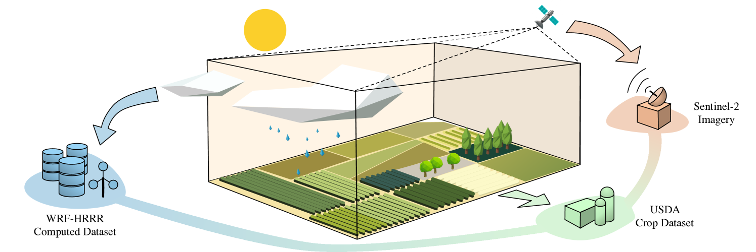
An Open and Large-Scale Dataset for Multi-Modal Climate Change-aware Crop Yield Predictions
Fudong Lin, Kaleb Guillot, Summer Crawford, Yihe Zhang, Xu Yuan, Nian-Feng Tzeng
Precise crop yield predictions are of national importance for ensuring food security and sustainable agricultural practices. While AI-for-science approaches have exhibited promising achievements in solving many scientific problems such as drug discovery, precipitation nowcasting, etc., the development of deep learning models for predicting crop yields is constantly hindered by the lack of an open and large-scale deep learning-ready dataset with multiple modalities to accommodate sufficient information. To remedy this, we introduce the CropNet dataset, the first terabyte-sized, publicly available, and multi-modal dataset specifically targeting climate change-aware crop yield predictions for the contiguous United States (U.S.) continent at the county level. Our CropNet dataset is composed of three modalities of data, i.e., Sentinel-2 Imagery, WRF-HRRR Computed Dataset, and USDA Crop Dataset, for over 2200 U.S. counties spanning 6 years (2017-2022), expected to facilitate researchers in developing versatile deep learning models for timely and precisely predicting crop yields at the county-level, by accounting for the effects of both short-term growing season weather variations and long-term climate change on crop yields. Besides, we develop the CropNet package, offering three types of APIs, for facilitating researchers in downloading the CropNet data on the fly over the time and region of interest, and flexibly building their deep learning models for accurate crop yield predictions. Extensive experiments have been conducted on our CropNet dataset via employing various types of deep learning solutions, with the results validating the general applicability and the efficacy of the CropNet dataset in climate change-aware crop yield predictions.
Read more6/18/2024