A community palm model

0
Sign in to get full access
Overview
- This paper proposes a model for understanding the dynamics of palm communities in a given region.
- The model takes into account factors such as growth, competition, and environmental conditions to simulate the evolution of palm populations over time.
- The researchers validate the model using field data from palm communities in South America and demonstrate its ability to capture key patterns and trends.
Plain English Explanation
The researchers have developed a model that helps us understand how palm tree communities change over time. Palms are an important part of many ecosystems, but it can be challenging to predict how their populations will evolve, especially when they interact with each other and respond to their environment.
The model considers factors like how fast palms grow, how they compete for resources, and how environmental conditions (like rainfall or temperature) affect them. By incorporating these elements, the researchers can simulate the long-term dynamics of palm communities. They tested the model using real-world data on palm populations in South America and found that it accurately captured the key patterns and trends observed in those communities.
This model could be useful for land managers, conservation biologists, and others who need to understand and predict the behavior of palm-dominated ecosystems. By simulating how palm communities might change over time, the model can inform decisions about how to manage and protect these important natural resources.
Technical Explanation
The researchers developed a community-level model to simulate the dynamics of palm populations over time. The model incorporates several key processes, including:
- Growth: The model tracks the size and age of individual palm trees and simulates their growth based on factors like resource availability and environmental conditions.
- Competition: The model accounts for competition between palms for limited resources like light, water, and nutrients, and how this competition affects their growth and survival.
- Environmental Factors: The model incorporates environmental variables, such as rainfall and temperature, and how they influence the growth and survival of palm trees.
To validate the model, the researchers used field data from palm communities in South America, including information on the size, density, and spatial distribution of palm trees. They ran the model using this data and found that it was able to accurately reproduce the observed patterns and trends in the palm communities, such as the size structure and spatial distribution of the palms.
The model provides a framework for understanding the long-term dynamics of palm-dominated ecosystems and how they might respond to changes in environmental conditions or management practices. This could be valuable for informing conservation and land-use decisions in regions where palms play a significant role in the local ecology.
Critical Analysis
The researchers have developed a comprehensive model that captures many of the key processes shaping palm community dynamics. However, there are a few potential limitations and areas for further research:
- Data Availability: The model validation was based on data from a relatively small number of palm communities in South America. Expanding the model validation to a wider range of palm ecosystems would help strengthen confidence in its predictive capabilities.
- Complexity versus Parsimony: The model includes a relatively large number of parameters and processes, which could make it challenging to apply in some contexts. Exploring ways to simplify the model while maintaining its predictive power could improve its usability.
- Interactions with other Species: The current model focuses solely on palm dynamics, but in many ecosystems, palms interact with other plant and animal species. Incorporating these interactions could provide a more comprehensive understanding of palm community ecology.
Overall, the researchers have made a valuable contribution to the field of community ecology with this model. By simulating the long-term dynamics of palm communities, it can inform conservation and management decisions in regions where palms are ecologically important.
Conclusion
The researchers have developed a community-level model that can simulate the long-term dynamics of palm populations, taking into account factors such as growth, competition, and environmental conditions. The model has been validated using field data from palm communities in South America and shows promise for informing conservation and land-use decisions in regions where palms play a significant ecological role.
While the model has some limitations, it represents a valuable step forward in our understanding of how palm-dominated ecosystems may respond to changes over time. Further research and refinement of the model could lead to even more accurate predictions and more informed decision-making when it comes to the management and protection of these important natural resources.
This summary was produced with help from an AI and may contain inaccuracies - check out the links to read the original source documents!
Related Papers
0
A community palm model
Nicholas Clinton, Andreas Vollrath, Remi D'annunzio, Desheng Liu, Henry B. Glick, Adri`a Descals, Alicia Sullivan, Oliver Guinan, Jacob Abramowitz, Fred Stolle, Chris Goodman, Tanya Birch, David Quinn, Olga Danylo, Tijs Lips, Daniel Coelho, Enikoe Bihari, Bryce Cronkite-Ratcliff, Ate Poortinga, Atena Haghighattalab, Evan Notman, Michael DeWitt, Aaron Yonas, Gennadii Donchyts, Devaja Shah, David Saah, Karis Tenneson, Nguyen Hanh Quyen, Megha Verma, Andrew Wilcox
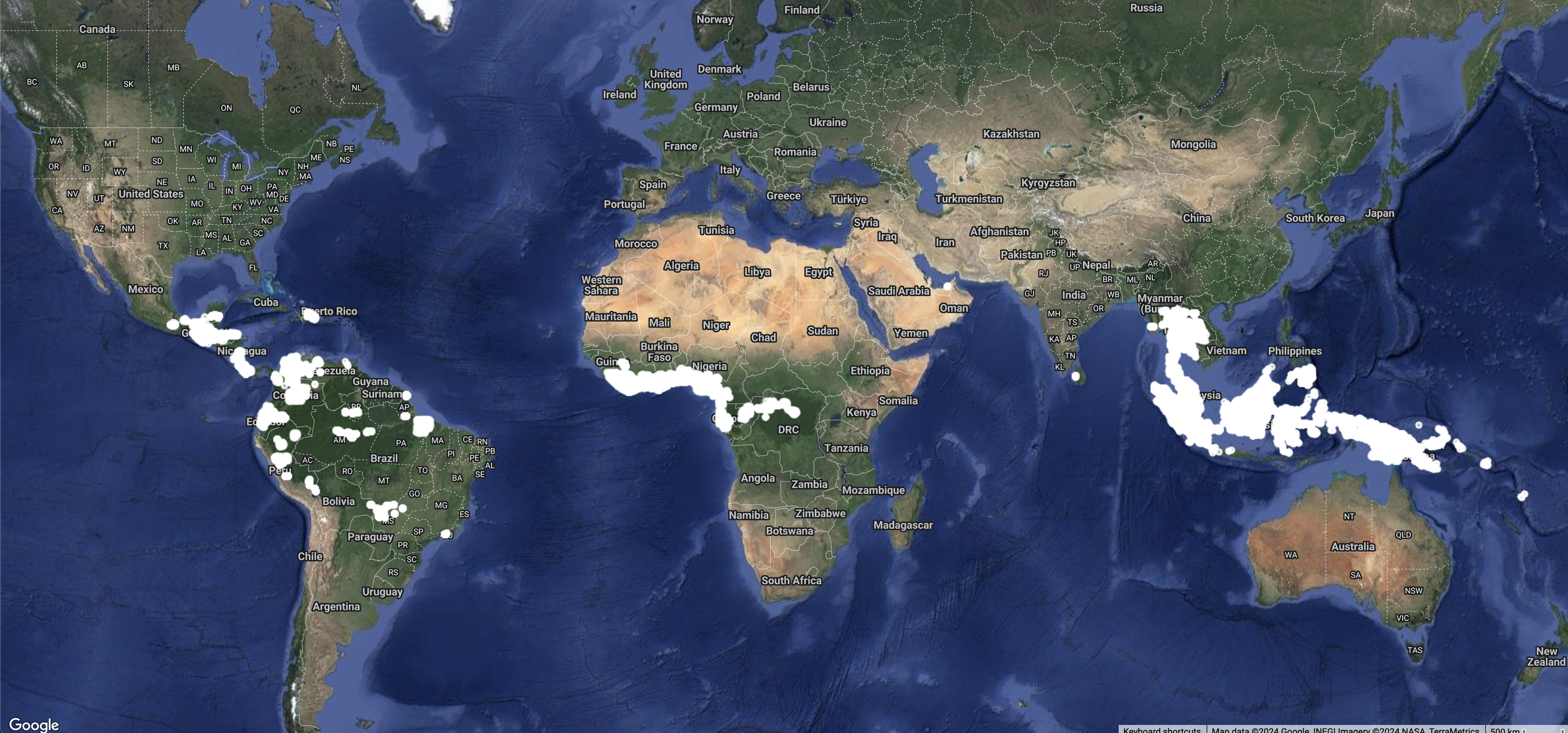
Palm oil production has been identified as one of the major drivers of deforestation for tropical countries. To meet supply chain objectives, commodity producers and other stakeholders need timely information of land cover dynamics in their supply shed. However, such data are difficult to obtain from suppliers who may lack digital geographic representations of their supply sheds and production locations. Here we present a community model, a machine learning model trained on pooled data sourced from many different stakeholders, to develop a specific land cover probability map, in this case a semi-global oil palm map. An advantage of this method is the inclusion of varied inputs, the ability to easily update the model as new training data becomes available and run the model on any year that input imagery is available. Inclusion of diverse data sources into one probability map can help establish a shared understanding across stakeholders on the presence and absence of a land cover or commodity (in this case oil palm). The model predictors are annual composites built from publicly available satellite imagery provided by Sentinel-1, Sentinel-2, and ALOS DSM. We provide map outputs as the probability of palm in a given pixel, to reflect the uncertainty of the underlying state (palm or not palm). The initial version of this model provides global accuracy estimated to be approximately 90% (at 0.5 probability threshold) from spatially partitioned test data. This model, and resulting oil palm probability map products are useful for accurately identifying the geographic footprint of palm cultivation. Used in conjunction with timely deforestation information, this palm model is useful for understanding the risk of continued oil palm plantation expansion in sensitive forest areas.
Read more5/16/2024
0
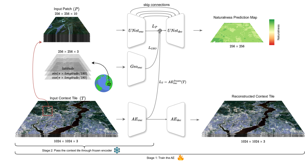
Mapping Land Naturalness from Sentinel-2 using Deep Contextual and Geographical Priors
Burak Ekim, Michael Schmitt
In recent decades, the causes and consequences of climate change have accelerated, affecting our planet on an unprecedented scale. This change is closely tied to the ways in which humans alter their surroundings. As our actions continue to impact natural areas, using satellite images to observe and measure these effects has become crucial for understanding and combating climate change. Aiming to map land naturalness on the continuum of modern human pressure, we have developed a multi-modal supervised deep learning framework that addresses the unique challenges of satellite data and the task at hand. We incorporate contextual and geographical priors, represented by corresponding coordinate information and broader contextual information, including and surrounding the immediate patch to be predicted. Our framework improves the model's predictive performance in mapping land naturalness from Sentinel-2 data, a type of multi-spectral optical satellite imagery. Recognizing that our protective measures are only as effective as our understanding of the ecosystem, quantifying naturalness serves as a crucial step toward enhancing our environmental stewardship.
Read more6/28/2024

0
Unified Deep Learning Model for Global Prediction of Aboveground Biomass, Canopy Height and Cover from High-Resolution, Multi-Sensor Satellite Imagery
Manuel Weber, Carly Beneke, Clyde Wheeler
Regular measurement of carbon stock in the world's forests is critical for carbon accounting and reporting under national and international climate initiatives, and for scientific research, but has been largely limited in scalability and temporal resolution due to a lack of ground based assessments. Increasing efforts have been made to address these challenges by incorporating remotely sensed data. We present a new methodology which uses multi-sensor, multi-spectral imagery at a resolution of 10 meters and a deep learning based model which unifies the prediction of above ground biomass density (AGBD), canopy height (CH), canopy cover (CC) as well as uncertainty estimations for all three quantities. The model is trained on millions of globally sampled GEDI-L2/L4 measurements. We validate the capability of our model by deploying it over the entire globe for the year 2023 as well as annually from 2016 to 2023 over selected areas. The model achieves a mean absolute error for AGBD (CH, CC) of 26.1 Mg/ha (3.7 m, 9.9 %) and a root mean squared error of 50.6 Mg/ha (5.4 m, 15.8 %) on a globally sampled test dataset, demonstrating a significant improvement over previously published results. We also report the model performance against independently collected ground measurements published in the literature, which show a high degree of correlation across varying conditions. We further show that our pre-trained model facilitates seamless transferability to other GEDI variables due to its multi-head architecture.
Read more8/22/2024

0
Planted: a dataset for planted forest identification from multi-satellite time series
Luis Miguel Pazos-Out'on, Cristina Nader Vasconcelos, Anton Raichuk, Anurag Arnab, Dan Morris, Maxim Neumann
Protecting and restoring forest ecosystems is critical for biodiversity conservation and carbon sequestration. Forest monitoring on a global scale is essential for prioritizing and assessing conservation efforts. Satellite-based remote sensing is the only viable solution for providing global coverage, but to date, large-scale forest monitoring is limited to single modalities and single time points. In this paper, we present a dataset consisting of data from five public satellites for recognizing forest plantations and planted tree species across the globe. Each satellite modality consists of a multi-year time series. The dataset, named PlantD, includes over 2M examples of 64 tree label classes (46 genera and 40 species), distributed among 41 countries. This dataset is released to foster research in forest monitoring using multimodal, multi-scale, multi-temporal data sources. Additionally, we present initial baseline results and evaluate modality fusion and data augmentation approaches for this dataset.
Read more6/28/2024