DeepExtremeCubes: Integrating Earth system spatio-temporal data for impact assessment of climate extremes

0

Sign in to get full access
Overview
- Integrates Earth system spatio-temporal data to assess the impact of climate extremes
- Uses a deep learning model called "DeepExtremeCubes" for the analysis
- Aims to provide a comprehensive framework for understanding the effects of climate change on various systems
Plain English Explanation
The paper titled "DeepExtremeCubes: Integrating Earth system spatio-temporal data for impact assessment of climate extremes" presents a novel approach to analyzing the effects of climate change on different aspects of the Earth system. The researchers have developed a deep learning model called "DeepExtremeCubes" that integrates various types of spatio-temporal data, such as weather data, satellite imagery, and socioeconomic indicators, to assess the impact of climate extremes.
By combining these diverse datasets, the researchers hope to gain a more holistic understanding of how climate change affects different systems, from the natural environment to human communities. This information can then be used to inform climate adaptation strategies and support decision-making processes.
Technical Explanation
The DeepExtremeCubes model integrates various types of Earth system spatio-temporal data, including climate variables, satellite imagery, and socioeconomic indicators, to assess the impact of climate extremes. The researchers use a deep learning architecture to capture the complex relationships between these different datasets and to identify patterns that may not be easily discernible through traditional analytical methods.
The model leverages techniques such as convolutional neural networks and long short-term memory (LSTM) networks to effectively process the spatio-temporal data and generate insights into the impacts of climate extremes. The researchers have also developed novel data preprocessing and feature engineering techniques to ensure that the model can effectively learn from the diverse and complex datasets.
Critical Analysis
The DeepExtremeCubes framework represents a significant advancement in the field of climate impact assessment, as it aims to integrate multiple data sources to provide a more comprehensive understanding of the effects of climate change. However, the paper acknowledges several limitations and areas for further research.
One key challenge is the availability and quality of the input data, as the researchers note that some datasets may have missing or inconsistent information. Additionally, the complexity of the model and the large number of parameters may make it computationally intensive and difficult to interpret, which could limit its practical applications.
Further research is needed to explore the robustness and generalizability of the DeepExtremeCubes model, as well as to investigate ways to improve its interpretability and transparency. Engaging with stakeholders from various sectors, such as policymakers and community organizations, could also help to ensure that the model's outputs are relevant and actionable for real-world decision-making.
Conclusion
The DeepExtremeCubes framework presented in this paper represents a promising approach to integrating Earth system spatio-temporal data for the assessment of climate extremes. By leveraging advanced deep learning techniques, the model has the potential to provide valuable insights into the complex and interconnected impacts of climate change on natural and human systems.
As the research community continues to grapple with the challenges posed by climate change, tools like DeepExtremeCubes will be increasingly important in supporting evidence-based decision-making and developing effective climate adaptation strategies. The critical analysis and identification of areas for further research presented in this paper will help to guide future work in this field and advance our understanding of the profound changes facing our planet.
This summary was produced with help from an AI and may contain inaccuracies - check out the links to read the original source documents!
Related Papers
0
DeepExtremeCubes: Integrating Earth system spatio-temporal data for impact assessment of climate extremes
Chaonan Ji, Tonio Fincke, Vitus Benson, Gustau Camps-Valls, Miguel-Angel Fernandez-Torres, Fabian Gans, Guido Kraemer, Francesco Martinuzzi, David Montero, Karin Mora, Oscar J. Pellicer-Valero, Claire Robin, Maximilian Soechting, Melanie Weynants, Miguel D. Mahecha
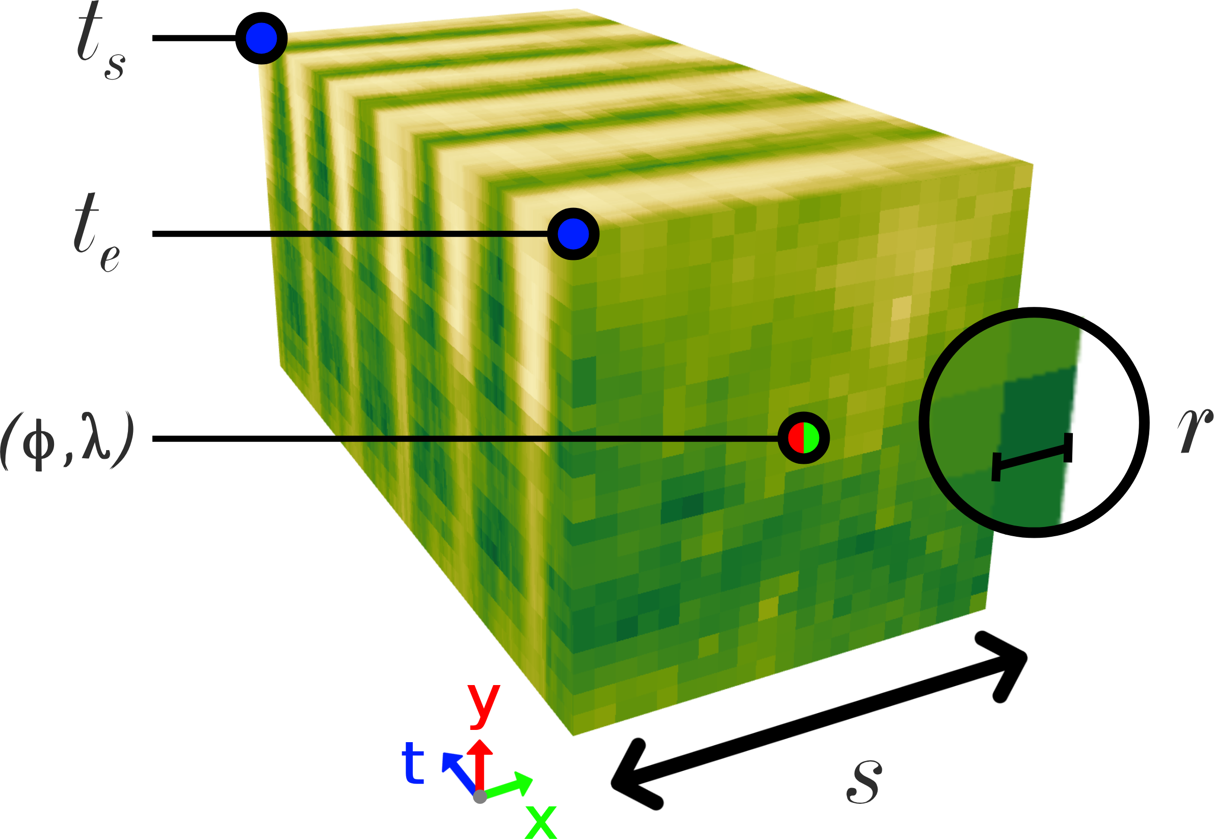
With climate extremes' rising frequency and intensity, robust analytical tools are crucial to predict their impacts on terrestrial ecosystems. Machine learning techniques show promise but require well-structured, high-quality, and curated analysis-ready datasets. Earth observation datasets comprehensively monitor ecosystem dynamics and responses to climatic extremes, yet the data complexity can challenge the effectiveness of machine learning models. Despite recent progress in deep learning to ecosystem monitoring, there is a need for datasets specifically designed to analyse compound heatwave and drought extreme impact. Here, we introduce the DeepExtremeCubes database, tailored to map around these extremes, focusing on persistent natural vegetation. It comprises over 40,000 spatially sampled small data cubes (i.e. minicubes) globally, with a spatial coverage of 2.5 by 2.5 km. Each minicube includes (i) Sentinel-2 L2A images, (ii) ERA5-Land variables and generated extreme event cube covering 2016 to 2022, and (iii) ancillary land cover and topography maps. The paper aims to (1) streamline data accessibility, structuring, pre-processing, and enhance scientific reproducibility, and (2) facilitate biosphere dynamics forecasting in response to compound extremes.
Read more6/27/2024
0
On-Demand Earth System Data Cubes
David Montero, C'esar Aybar, Chaonan Ji, Guido Kraemer, Maximilian Sochting, Khalil Teber, Miguel D. Mahecha
Advancements in Earth system science have seen a surge in diverse datasets. Earth System Data Cubes (ESDCs) have been introduced to efficiently handle this influx of high-dimensional data. ESDCs offer a structured, intuitive framework for data analysis, organising information within spatio-temporal grids. The structured nature of ESDCs unlocks significant opportunities for Artificial Intelligence (AI) applications. By providing well-organised data, ESDCs are ideally suited for a wide range of sophisticated AI-driven tasks. An automated framework for creating AI-focused ESDCs with minimal user input could significantly accelerate the generation of task-specific training data. Here we introduce cubo, an open-source Python tool designed for easy generation of AI-focused ESDCs. Utilising collections in SpatioTemporal Asset Catalogs (STAC) that are stored as Cloud Optimised GeoTIFFs (COGs), cubo efficiently creates ESDCs, requiring only central coordinates, spatial resolution, edge size, and time range.
Read more4/23/2024
0
Validating Deep-Learning Weather Forecast Models on Recent High-Impact Extreme Events
Olivier C. Pasche, Jonathan Wider, Zhongwei Zhang, Jakob Zscheischler, Sebastian Engelke
The forecast accuracy of deep-learning-based weather prediction models is improving rapidly, leading many to speak of a second revolution in weather forecasting. With numerous methods being developed, and limited physical guarantees offered by deep-learning models, there is a critical need for comprehensive evaluation of these emerging techniques. While this need has been partly fulfilled by benchmark datasets, they provide little information on rare and impactful extreme events, or on compound impact metrics, for which model accuracy might degrade due to misrepresented dependencies between variables. To address these issues, we compare deep-learning weather prediction models (GraphCast, PanguWeather, FourCastNet) and ECMWF's high-resolution forecast (HRES) system in three case studies: the 2021 Pacific Northwest heatwave, the 2023 South Asian humid heatwave, and the North American winter storm in 2021. We find evidence that machine learning (ML) weather prediction models can locally achieve similar accuracy to HRES on record-shattering events such as the 2021 Pacific Northwest heatwave and even forecast the compound 2021 North American winter storm substantially better. However, extrapolating to extreme conditions may impact machine learning models more severely than HRES, as evidenced by the comparable or superior spatially- and temporally-aggregated forecast accuracy of HRES for the two heatwaves studied. The ML forecasts also lack variables required to assess the health risks of events such as the 2023 South Asian humid heatwave. Generally, case-study-driven, impact-centric evaluation can complement existing research, increase public trust, and aid in developing reliable ML weather prediction models.
Read more4/30/2024

0
Vision-Language Models Meet Meteorology: Developing Models for Extreme Weather Events Detection with Heatmaps
Jian Chen, Peilin Zhou, Yining Hua, Dading Chong, Meng Cao, Yaowei Li, Zixuan Yuan, Bing Zhu, Junwei Liang
Real-time detection and prediction of extreme weather protect human lives and infrastructure. Traditional methods rely on numerical threshold setting and manual interpretation of weather heatmaps with Geographic Information Systems (GIS), which can be slow and error-prone. Our research redefines Extreme Weather Events Detection (EWED) by framing it as a Visual Question Answering (VQA) problem, thereby introducing a more precise and automated solution. Leveraging Vision-Language Models (VLM) to simultaneously process visual and textual data, we offer an effective aid to enhance the analysis process of weather heatmaps. Our initial assessment of general-purpose VLMs (e.g., GPT-4-Vision) on EWED revealed poor performance, characterized by low accuracy and frequent hallucinations due to inadequate color differentiation and insufficient meteorological knowledge. To address these challenges, we introduce ClimateIQA, the first meteorological VQA dataset, which includes 8,760 wind gust heatmaps and 254,040 question-answer pairs covering four question types, both generated from the latest climate reanalysis data. We also propose Sparse Position and Outline Tracking (SPOT), an innovative technique that leverages OpenCV and K-Means clustering to capture and depict color contours in heatmaps, providing ClimateIQA with more accurate color spatial location information. Finally, we present Climate-Zoo, the first meteorological VLM collection, which adapts VLMs to meteorological applications using the ClimateIQA dataset. Experiment results demonstrate that models from Climate-Zoo substantially outperform state-of-the-art general VLMs, achieving an accuracy increase from 0% to over 90% in EWED verification. The datasets and models in this study are publicly available for future climate science research: https://github.com/AlexJJJChen/Climate-Zoo.
Read more6/17/2024