DurLAR: A High-fidelity 128-channel LiDAR Dataset with Panoramic Ambient and Reflectivity Imagery for Multi-modal Autonomous Driving Applications

0
Sign in to get full access
Overview
• This paper introduces DurLAR, a high-fidelity 128-channel LiDAR dataset with panoramic ambient and reflectivity imagery, designed for multi-modal autonomous driving applications. • The dataset provides a comprehensive and diverse set of data, including point clouds, camera images, and metadata, aiming to enable advancements in perception, mapping, and scene understanding for self-driving vehicles.
Plain English Explanation
• DurLAR is a new dataset that contains highly detailed 3D data from a 128-channel LiDAR sensor, along with panoramic images that capture the surrounding environment. • The dataset is designed to help researchers and engineers develop better autonomous driving systems by providing a rich and diverse set of sensor data to work with. • LiDAR is a technology that uses laser beams to create 3D maps of the environment. The 128-channel LiDAR in this dataset provides an extremely high-resolution point cloud, which can help improve object detection, tracking, and scene understanding. • The panoramic images, which show a 360-degree view of the environment, can be combined with the LiDAR data to create more comprehensive models of the driving scene. • By having access to this robust, multi-modal dataset, researchers can explore new techniques for fusing different sensor data types, which could lead to significant advancements in autonomous driving capabilities.
Technical Explanation
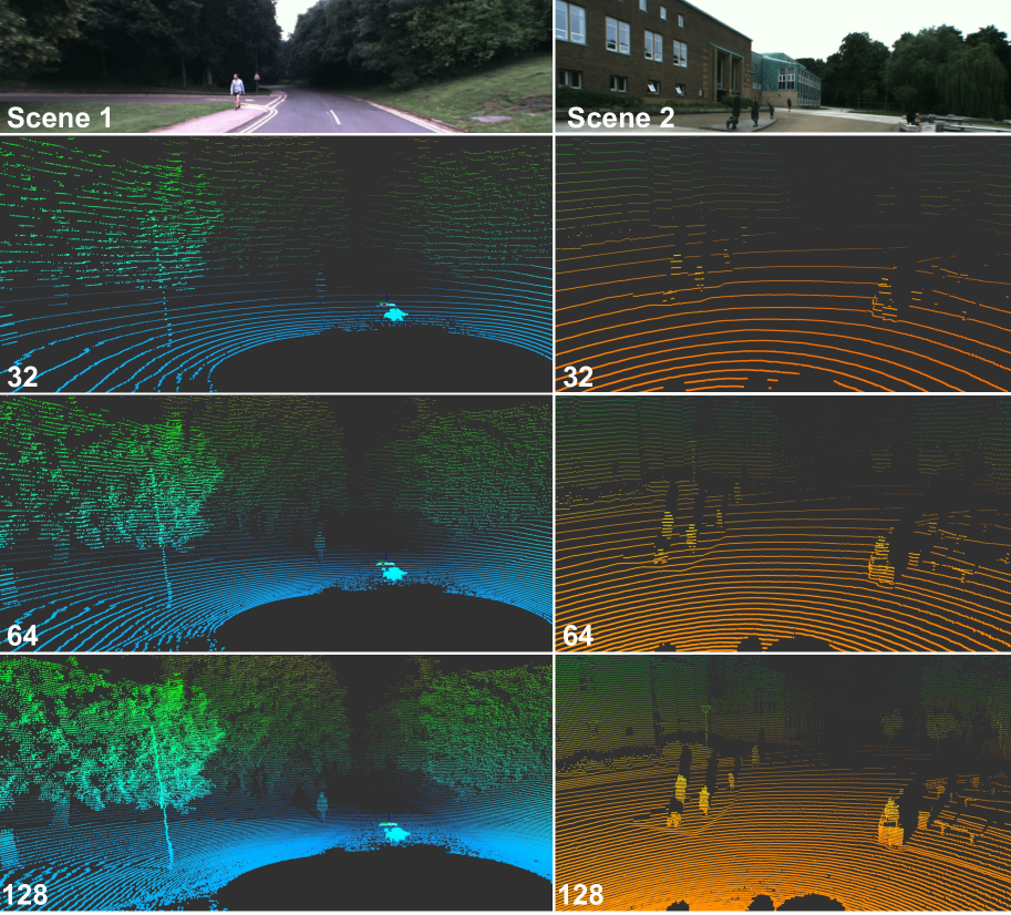
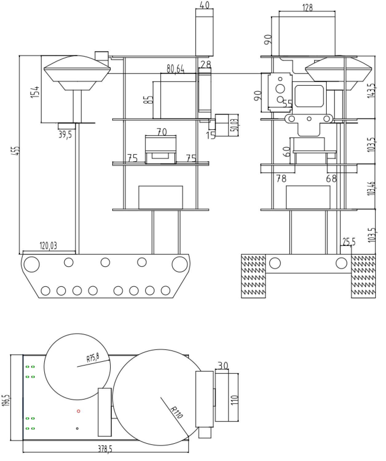
• The DurLAR dataset contains data from a 128-channel LiDAR sensor, which can capture detailed 3D point clouds of the surrounding environment. • In addition to the LiDAR data, the dataset includes panoramic ambient and reflectivity imagery, providing a complementary set of visual information. • The dataset was collected using a custom-built sensor platform, which was mounted on a vehicle and driven through various urban and suburban environments. • The dataset includes over 2.3 million LiDAR scans and 1.2 million panoramic images, covering a diverse range of driving scenarios, weather conditions, and lighting conditions. • The data is accompanied by detailed metadata, such as timestamp information, sensor calibration parameters, and GPS/IMU data, enabling researchers to accurately align and fuse the different sensor modalities.
Critical Analysis
• The DurLAR dataset provides a significant advancement in the availability of high-fidelity, multi-modal data for autonomous driving research. • However, the dataset is limited to a specific geographic region and may not capture the full diversity of driving environments encountered globally. • Additionally, the dataset does not include other sensor modalities, such as radar or thermal cameras, which could further enhance the understanding of the driving scene. • Researchers should also be cautious about potential biases or dataset shift when applying models trained on DurLAR to real-world deployment scenarios.
Conclusion
• The DurLAR dataset represents a valuable resource for the autonomous driving research community, providing a comprehensive set of high-quality, multi-modal sensor data. • By leveraging the rich information in this dataset, researchers can explore new techniques for sensor fusion, perception, and scene understanding, potentially leading to significant breakthroughs in the development of safe and reliable self-driving vehicles. • The availability of such datasets, like DIDLMA, ParisLuCo3D, and Multi-Modal Data for Efficient 3D Scene Understanding, is crucial for advancing the state-of-the-art in autonomous driving research.
This summary was produced with help from an AI and may contain inaccuracies - check out the links to read the original source documents!
Related Papers
0
DurLAR: A High-fidelity 128-channel LiDAR Dataset with Panoramic Ambient and Reflectivity Imagery for Multi-modal Autonomous Driving Applications
Li Li, Khalid N. Ismail, Hubert P. H. Shum, Toby P. Breckon
We present DurLAR, a high-fidelity 128-channel 3D LiDAR dataset with panoramic ambient (near infrared) and reflectivity imagery, as well as a sample benchmark task using depth estimation for autonomous driving applications. Our driving platform is equipped with a high resolution 128 channel LiDAR, a 2MPix stereo camera, a lux meter and a GNSS/INS system. Ambient and reflectivity images are made available along with the LiDAR point clouds to facilitate multi-modal use of concurrent ambient and reflectivity scene information. Leveraging DurLAR, with a resolution exceeding that of prior benchmarks, we consider the task of monocular depth estimation and use this increased availability of higher resolution, yet sparse ground truth scene depth information to propose a novel joint supervised/self-supervised loss formulation. We compare performance over both our new DurLAR dataset, the established KITTI benchmark and the Cityscapes dataset. Our evaluation shows our joint use supervised and self-supervised loss terms, enabled via the superior ground truth resolution and availability within DurLAR improves the quantitative and qualitative performance of leading contemporary monocular depth estimation approaches (RMSE=3.639, Sq Rel=0.936).
Read more6/17/2024
0
DIDLM:A Comprehensive Multi-Sensor Dataset with Infrared Cameras, Depth Cameras, LiDAR, and 4D Millimeter-Wave Radar in Challenging Scenarios for 3D Mapping
WeiSheng Gong, Chen He, KaiJie Su, QingYong Li
This study presents a comprehensive multi-sensor dataset designed for 3D mapping in challenging indoor and outdoor environments. The dataset comprises data from infrared cameras, depth cameras, LiDAR, and 4D millimeter-wave radar, facilitating exploration of advanced perception and mapping techniques. Integration of diverse sensor data enhances perceptual capabilities in extreme conditions such as rain, snow, and uneven road surfaces. The dataset also includes interactive robot data at different speeds indoors and outdoors, providing a realistic background environment. Slam comparisons between similar routes are conducted, analyzing the influence of different complex scenes on various sensors. Various SLAM algorithms are employed to process the dataset, revealing performance differences among algorithms in different scenarios. In summary, this dataset addresses the problem of data scarcity in special environments, fostering the development of perception and mapping algorithms for extreme conditions. Leveraging multi-sensor data including infrared, depth cameras, LiDAR, 4D millimeter-wave radar, and robot interactions, the dataset advances intelligent mapping and perception capabilities.Our dataset is available at https://github.com/GongWeiSheng/DIDLM.
Read more4/16/2024
📶
0
LuSNAR:A Lunar Segmentation, Navigation and Reconstruction Dataset based on Muti-sensor for Autonomous Exploration
Jiayi Liu, Qianyu Zhang, Xue Wan, Shengyang Zhang, Yaolin Tian, Haodong Han, Yutao Zhao, Baichuan Liu, Zeyuan Zhao, Xubo Luo
With the complexity of lunar exploration missions, the moon needs to have a higher level of autonomy. Environmental perception and navigation algorithms are the foundation for lunar rovers to achieve autonomous exploration. The development and verification of algorithms require highly reliable data support. Most of the existing lunar datasets are targeted at a single task, lacking diverse scenes and high-precision ground truth labels. To address this issue, we propose a multi-task, multi-scene, and multi-label lunar benchmark dataset LuSNAR. This dataset can be used for comprehensive evaluation of autonomous perception and navigation systems, including high-resolution stereo image pairs, panoramic semantic labels, dense depth maps, LiDAR point clouds, and the position of rover. In order to provide richer scene data, we built 9 lunar simulation scenes based on Unreal Engine. Each scene is divided according to topographic relief and the density of objects. To verify the usability of the dataset, we evaluated and analyzed the algorithms of semantic segmentation, 3D reconstruction, and autonomous navigation. The experiment results prove that the dataset proposed in this paper can be used for ground verification of tasks such as autonomous environment perception and navigation, and provides a lunar benchmark dataset for testing the accessibility of algorithm metrics. We make LuSNAR publicly available at: https://github.com/autumn999999/LuSNAR-dataset.
Read more9/6/2024
👨🏫
0
ParisLuco3D: A high-quality target dataset for domain generalization of LiDAR perception
Jules Sanchez, Louis Soum-Fontez, Jean-Emmanuel Deschaud, Francois Goulette
LiDAR is an essential sensor for autonomous driving by collecting precise geometric information regarding a scene. %Exploiting this information for perception is interesting as the amount of available data increases. As the performance of various LiDAR perception tasks has improved, generalizations to new environments and sensors has emerged to test these optimized models in real-world conditions. This paper provides a novel dataset, ParisLuco3D, specifically designed for cross-domain evaluation to make it easier to evaluate the performance utilizing various source datasets. Alongside the dataset, online benchmarks for LiDAR semantic segmentation, LiDAR object detection, and LiDAR tracking are provided to ensure a fair comparison across methods. The ParisLuco3D dataset, evaluation scripts, and links to benchmarks can be found at the following website:https://npm3d.fr/parisluco3d
Read more6/5/2024